Wynantskill, New York
| Wynantskill, New York | |
|---|---|
| CDP | |
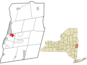 Location in Rensselaer County and the state of New York. | |
 Wynantskill, New York Location within the state of New York | |
| Coordinates: 42°41′32″N 73°38′40″W / 42.69222°N 73.64444°WCoordinates: 42°41′32″N 73°38′40″W / 42.69222°N 73.64444°W | |
| Country | United States |
| State | New York |
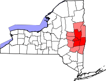
| County | Rensselaer |
| Area | |
| • Total | 2.4 sq mi (6.3 km2) |
| • Land | 2.4 sq mi (6.3 km2) |
| • Water | 0.0 sq mi (0.0 km2) |
| Elevation | 335 ft (102 m) |
| Population (2010) | |
| • Total | 3,276 |
| • Density | 1,400/sq mi (520/km2) |
| Time zone | Eastern (EST) (UTC-5) |
| • Summer (DST) | EDT (UTC-4) |
| ZIP code | 12198 |
| Area code(s) | 518 |
| FIPS code | 36-83349[1] |
| GNIS feature ID | 0971770[2] |
Wynantskill is a hamlet and census-designated place (CDP) in Rensselaer County, New York, United States. The population was 3,276 at the 2010 census. Wynantskill is located at the north town line and the northeast corner of the town of North Greenbush. The community is a suburb of Troy. NY Route 66 (Pawling Ave. in Troy, Main Ave. in Wynantskill) is the main route throughout the community. Wynantskill has a major grocery store, several banks, a restaurant, convenience stores, a post office, and a bowling alley, with almost all houses located on side streets off Main Ave. Other major roads are Whiteview Road, a primarily residential road that leads to Route 4; and West Sand Lake Road.
Geography
Wynantskill is located at 42°41′32″N 73°38′40″W / 42.69222°N 73.64444°W (42.692139, -73.644580).[3]
According to the United States Census Bureau, the CDP has a total area of 2.4 square miles (6.2 km2), all land.
Location
 |
City of Troy Neighborhood of Albia |
Town of Brunswick Neighborhood of Mountain View |
| |
| |
Town of Poestenkill | |||
| ||||
| | ||||
| Snyders Lake |
Demographics
As of the census[1] of 2000, there were 3,018 people, 1,246 households, and 857 families residing in the CDP. The population density was 1,245.1 per square mile (481.5/km²). There were 1,284 housing units at an average density of 529.7/sq mi (204.9/km²). The racial makeup of the CDP was 97.81% White, 0.53% African American, 0.20% Native American, 0.30% Asian, 0.03% Pacific Islander, 0.03% from other races, and 1.09% from two or more races. Hispanic or Latino of any race were 0.43% of the population.
There were 1,246 households out of which 28.3% had children under the age of 18 living with them, 55.6% were married couples living together, 10.0% had a female householder with no husband present, and 31.2% were non-families. 26.8% of all households were made up of individuals and 16.7% had someone living alone who was 65 years of age or older. The average household size was 2.42 and the average family size was 2.94.
In the CDP the population was spread out with 21.4% under the age of 18, 6.5% from 18 to 24, 27.3% from 25 to 44, 25.9% from 45 to 64, and 18.9% who were 65 years of age or older. The median age was 42 years. For every 100 females there were 90.5 males. For every 100 females age 18 and over, there were 88.4 males.
The median income for a household in the CDP was $51,988, and the median income for a family was $61,951. Males had a median income of $40,391 versus $30,086 for females. The per capita income for the CDP was $23,277. About 0.4% of families and 1.3% of the population were below the poverty line, including none of those under age 18 and 1.8% of those age 65 or over.
Schools
Wynantskill is home to the Gardner-Dickinson Elementary/Middle school, (Kindergarten through 8th Grade) but contains no high school. Most children from Wynantskill attend high school in nearby Enlarged City School District of Troy, Averill Park Central School District, Brunswick (Brittonkill) Central School District, or East Greenbush Central School District
In the past, the school board of this community has encountered difficulties in working with school system leaders, as evidenced in this report. http://nysut.org/newyorkteacher/backissues/1997-1998/970505wynantskill.html
See also
References
- 1 2 "American FactFinder". United States Census Bureau. Archived from the original on September 11, 2013. Retrieved 2008-01-31.
- ↑ "US Board on Geographic Names". United States Geological Survey. 2007-10-25. Retrieved 2008-01-31.
- ↑ "US Gazetteer files: 2010, 2000, and 1990". United States Census Bureau. 2011-02-12. Retrieved 2011-04-23.
Municipalities and communities of Rensselaer County, New York, United States | ||
|---|---|---|
| Cities | 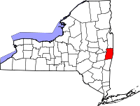 | |
| Towns | ||
| Villages | ||
| CDPs | ||
| Other hamlets | ||