Johnsonville, New York
| Johnsonville | |
|---|---|
| hamlet | |
 Johnsonville Location of Johnsonville in New York | |
| Coordinates: 42°54′50″N 73°30′51″W / 42.91389°N 73.51417°WCoordinates: 42°54′50″N 73°30′51″W / 42.91389°N 73.51417°W | |
| Country | United States |
| State | New York |
| County | Rensselaer |
| ZIP code | 12094 |
| Area code(s) | 518 |
Johnsonville is a hamlet located in the towns of Pittstown and Schaghticoke, New York. It was named for its settler, William Johnson.[1]
History
Johnsonville is considered a "railroad town" due to the importance of the railroad in the history of the area; however, it was an important industrial area even before the coming of railroad. Due to its close proximity to the Hoosic River, a tributary of the Hudson River, many factories sprung up along the river banks: flour, grist and lumber mills; axe factories; and other types of industry. The Johnsonville Axe Factory was once the largest axe factory in the world. The coming of the railroad in 1830 made it much easier for these factories to market and transport their products, and contributed to the industrial growth of the hamlet.
Although no passenger trains stop in Johnsonville anymore, the Boston and Maine Railroad's mainline continues to run through Johnsonville, transporting freight between New England and New York. "The B&M" is now owned by Pan Am Railways. The station house has long since been closed and today is a multi-unit apartment dwelling.
Today, Johnsonville is a mere shadow of what it used to be: it is a small, quiet bedroom community of commuters. All of the factories and buildings along the river have long since disappeared, and most of the farmland is gone. The gigantic railroad baron homes built during the heyday of the railroad still stand, but for the most part have all been broken up and redesigned into apartment buildings. The 110-year-old grain mill was recently converted into condominiums. Urban sprawl threatens what is left of the rural atmosphere, as farmland quickly disappears and cities move in ever closer.
The Baum–Wallis Farmstead, Cannon–Brownell–Herrington Farmstead, and Thomas–Wiley–Johnson Farmstead are listed on the National Register of Historic Places.[2][3]
References
- ↑ "Johnsonville Community Profile". ePodunk. Retrieved 2008-05-29.
- ↑ "National Register of Historic Places Listings". Weekly List of Actions Taken on Properties: 9/17/12 through 9/21/12. National Park Service. 2012-09-28.
- ↑ "National Register of Historic Places Listings". Weekly List of Actions Taken on Properties: 12/31/12 through 1/04/12. National Park Service. 2013-01-11.
External links
Municipalities and communities of Rensselaer County, New York, United States | ||
|---|---|---|
| Cities | 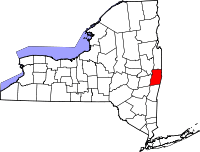 | |
| Towns | ||
| Villages | ||
| CDPs | ||
| Other hamlets | ||