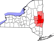
Columbia County, New York
| Columbia County, New York | |||
|---|---|---|---|
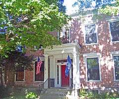 First Columbia County Courthouse | |||
| |||
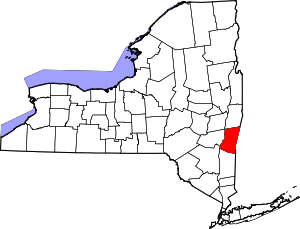 Location in the U.S. state of New York | |||
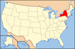 New York's location in the U.S. | |||
| Founded | 1786 | ||
| Named for | Christopher Columbus | ||
| Seat | Hudson | ||
| Largest city | Hudson | ||
| Area | |||
| • Total | 648 sq mi (1,678 km2) | ||
| • Land | 635 sq mi (1,645 km2) | ||
| • Water | 14 sq mi (36 km2), 2.1% | ||
| Population | |||
| • (2010) | 63,096 | ||
| • Density | 99/sq mi (38/km²) | ||
| Congressional district | 19th | ||
| Time zone | Eastern: UTC-5/-4 | ||
| Website |
www | ||


Columbia County is a county located in the U.S. state of New York. As of the 2010 census, the population was 63,096.[1] The county seat is Hudson.[2] The name comes from the Latin feminine form of the name of Christopher Columbus, which was at the time of the formation of the county a popular proposal for the name of the United States of America.
Columbia County comprises the Hudson, NY Micropolitan Statistical Area, which is also included in the Albany-Schenectady, NY Combined Statistical Area. It is located on the east side of the Hudson River.
History
At the time of European encounter, the area was occupied by the indigenous Mohican Indians. To the west of the river were the Mohawk and other four tribes of the Iroquois Confederacy, extending past what is now the border of New York state. The first known European exploration of Columbia County was in 1609, when Henry Hudson, an English explorer sailing for the Dutch, ventured up the Hudson River. An accident to his craft forced him to stop at what is now known as Columbia County, and search for food and supplies.[3] In 1612, the Dutch established trading posts and minor settlements, constructing New Amsterdam (today New York City) and Fort Orange (today Albany). Fort Orange became a center of the fur trade with the Mohawk people. Traders began to stop at midway points along the Hudson River, on their travels between New Amsterdam and Fort Orange. Small settlements arose along the river to supply the traders' ships.[3]
In 1649, Dutch colonists purchased land near Claverack and in 1667, more land was purchased.[4] As more Dutch arrived, the region slowly developed. In 1664, the English took over New Netherland and renamed it the Province of New York; they also renamed Fort Orange as Albany.[4]
In the late 17th century, Robert Livingston, a Scots immigrant by way of Rotterdam, built on his connections as Indian agent in the colony and purchased two large portions of land from the Native Americans. He gained much larger grants from the provincial government, for a total of 160,240 acres. He was made lord of the manor by the Crown, with all its perquisites, and started to develop the property with tenant farmers. In 1710, he sold 6,000 acres of his property to Queen Anne of England for use as work camps and resettlement of Palatine German refugees. The Crown had supported their passage to New York, and they were to pay off the costs as indentured labor.[5] Some 1200 Palatine Germans were brought to Livingston Manor (now known as Germantown). New York's Governor Hunter had also helped with these arrangements: the workers were to manufacture naval stores (e.g., pitch, resin, and turpentine) from the pine trees in the Catskill Mountains.
They were promised land for resettlement after completing their terms of indenture.[4] They were refugees from years of religious fighting along the border with France, as well as crop failures from a severe winter.[5] Work camps were established on both sides of the Hudson River. The Germans quickly established Protestant churches at the heart of their community, which recorded their weddings, births and deaths, among the first vital records kept in the colony.[5]
After many years, some of the colonists were granted land in the frontier of the central Mohawk Valley west of present-day Little Falls in the 100 lots of the Burnetsfield Patent; in the Schoharie Valley, and other areas, such as Palatine Bridge along the Mohawk River west of Schenectady. They were buffer communities between the British settlements and the Iroquois and French (the latter located mostly in Canada.)
Columbia County was formed in 1786 after the American Revolutionary War from portions of Albany County, once a vast area until new communities were developed and jurisdictions were organized. In 1799, the southern boundary of Columbia County was moved southward to include that portion of Livingston Manor located in Dutchess County.
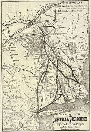
In the nineteenth century, the Vermont Central Railway was constructed to the area. It provided transportation north towards Rutland and Burlington, Vermont, and south towards the major junction town of Chatham, New York, for travel to points west, south and east.
Government and politics
Voters in Columbia County since the mid-19th century have mostly elected Republicans to office. But from 1996 - 2007, new voter registrations by Democrats have outpaced those by Republicans by a margin of 4 to 1.[6] This substantial shift in party affiliation is due in large part to an influx of people from New York City who now live either full or part-time in Columbia County.
Organizations such as "Vote Columbia" have led efforts to have New York City residents, who live in a heavily Democrat-controlled area, re-register to vote in their part-time residence of Columbia County, thus influencing the demographic of a lightly populated area that is home to an increasing number of people in weekend houses or retirement.[7] Local residents have expressed dismay that voters who stay in the county only on the weekends are influencing its politics and decisions over development, schools and other issues.[7]
The rise in the number of Democrats has resulted in a virtual tie among the number of Democrats, Republicans and non-affiliated voters in Columbia County. In the 2007 election cycle, Democrats came within two seats of taking control of the county Board of Supervisors. In the 2009 local elections, the Republicans increased their majority on the Board of Supervisors through the defeat of longtime Kinderhook Supervisor Doug McGivney. As Supervisor of the largest Town in the County, McGivney had the largest weighted vote on the Board of Supervisors. The Board of Supervisors is now led by Supervisor Pat Grattan (R-Kinderhook).
| Voter registration as of April 1, 2016[8] | |||||
|---|---|---|---|---|---|
| Party | Active voters | Inactive voters | Total voters | Percentage | |
| Democratic | 13,037 | 1,241 | 14,278 | 33.05% | |
| Republican | 11,774 | 724 | 12,498 | 28.93% | |
| Unaffiliated | 10,724 | 1,007 | 11,731 | 27.16% | |
| Other[nb 1] | 4,225 | 467 | 4,692 | 10.86% | |
| Total | 39,760 | 3,439 | 43,199 | 100% | |
Geography
According to the U.S. Census Bureau, the county has a total area of 648 square miles (1,680 km2), of which 635 square miles (1,640 km2) is land and 14 square miles (36 km2) (2.1%) is water.[9]
Columbia County is in the eastern part of New York State, southeast of Albany and immediately west of the Massachusetts border. The western border is the Hudson River.
The terrain is gentle, rolling hills, rising sharply into the Taconic and Berkshire Mountains along the state line.
The highest point is on the Massachusetts state line near the summit of Alander Mountain, at approximately 2,110 feet (643 m) above sea level, in the town of Copake. The lowest point is at or near sea level along the Hudson.
Columbia County is accessible by two limited-access highways. The Taconic State Parkway, which is not accessible to trucks or commercial traffic, runs through the center of the county from south to north, ending at an interchange with Interstate 90 and connecting the county with points south. Columbia County is the final New York county located along eastbound Interstate 90 (and the first county along westbound I-90), which passes through the towns of Chatham and Canaan as the Berkshire Connector portion of the New York Thruway. I-90 has two exits within the county; for the southbound Taconic State Parkway in Chatham, and for NYS Route 22 in Canaan.
Several other major routes cross Columbia County including north-south U.S. Route 9, east-west NYS Route 23, north-south NYS Route 22 and a short portion of east-west U.S. Route 20 in the county's northeastern corner.
Rivers and streams
The Hudson River forms the western border of the county. Other notable creeks include; the Ancram Creek, Claverack Creek, Copake Creek, Kinderhook Creek, Roeliff-Jansen Kill, and Valatie Kill. The Rossman Falls and Stuyvesant Falls lie on the Kinderhook Creek. Notable lakes and ponds include Copake Lake, Kinderhook Reservoir, Queechy Lake, and Lake Taghkanic.
Farms
Columbia County is home to many local farms supplying the area with fresh meat, eggs, herbs, and produce, including Letterbox Farm Collective, Blue Star Farm, Green Mead Farm, and Ironwood Farm.[10]
Adjacent counties
- Rensselaer County - north
- Berkshire County, Massachusetts - east
- Dutchess County - south
- Ulster County - southwest
- Greene County - west
- Albany County - northwest
- Litchfield County, Connecticut - southeast
National protected area
Demographics
| Historical population | |||
|---|---|---|---|
| Census | Pop. | %± | |
| 1790 | 27,496 | — | |
| 1800 | 35,322 | 28.5% | |
| 1810 | 32,390 | −8.3% | |
| 1820 | 38,330 | 18.3% | |
| 1830 | 39,907 | 4.1% | |
| 1840 | 43,252 | 8.4% | |
| 1850 | 43,073 | −0.4% | |
| 1860 | 47,172 | 9.5% | |
| 1870 | 47,044 | −0.3% | |
| 1880 | 47,928 | 1.9% | |
| 1890 | 46,172 | −3.7% | |
| 1900 | 43,211 | −6.4% | |
| 1910 | 43,658 | 1.0% | |
| 1920 | 38,930 | −10.8% | |
| 1930 | 41,617 | 6.9% | |
| 1940 | 41,464 | −0.4% | |
| 1950 | 43,182 | 4.1% | |
| 1960 | 47,322 | 9.6% | |
| 1970 | 51,519 | 8.9% | |
| 1980 | 59,487 | 15.5% | |
| 1990 | 62,982 | 5.9% | |
| 2000 | 63,094 | 0.2% | |
| 2010 | 63,096 | 0.0% | |
| Est. 2015 | 61,509 | [11] | −2.5% |
| U.S. Decennial Census[12] 1790-1960[13] 1900-1990[14] 1990-2000[15] 2010-2013[1] | |||
As of the census[16] of 2000, there were 63,094 people, 24,796 households, and 16,588 families residing in the county. The population density was 99 people per square mile (38/km²). There were 30,207 housing units at an average density of 48 per square mile (18/km²). The racial makeup of the county was 92.09% White, 4.52% Black or African American, 0.21% Native American, 0.80% Asian, 0.03% Pacific Islander, 0.90% from other races, and 1.45% from two or more races. 2.53% of the population were Hispanic or Latino of any race. 17.2% were of German, 14.7% Italian, 14.5% Irish, 9.0% English, 6.3% Polish and 6.1% American ancestry according to Census 2000. 94.0% spoke English and 2.1% Spanish as their first language.
There were 24,796 households out of which 29.90% had children under the age of 18 living with them, 52.20% were married couples living together, 10.30% had a female householder with no husband present, and 33.10% were non-families. 27.10% of all households were made up of individuals and 11.50% had someone living alone who was 65 years of age or older. The average household size was 2.43 and the average family size was 2.95.
In the county the population was spread out with 24.10% under the age of 18, 6.40% from 18 to 24, 26.90% from 25 to 44, 26.30% from 45 to 64, and 16.40% who were 65 years of age or older. The median age was 40 years. For every 100 females there were 99.00 males. For every 100 females age 18 and over, there were 95.30 males.
The median income for a household in the county was $41,915, and the median income for a family was $49,357. Males had a median income of $34,702 versus $25,878 for females. The per capita income for the county was $22,265. About 6.40% of families and 9.00% of the population were below the poverty line, including 11.80% of those under age 18 and 6.80% of those age 65 or over.
Communities
City
- Hudson (county seat)
Towns
Villages
Census-designated places
Hamlets
- Boston Corner
- Columbiaville
- Craryville
- East Chatham
- Elizaville
- Humphreysville
- Old Chatham
- Spencertown
- Stuyvesant Falls
Education
Columbia–Greene Community College is located in Hudson, NY.
See also
- List of counties in New York
- National Register of Historic Places listings in Columbia County, New York
Notes
- ↑ Included are voters affiliated with the Conservative Party, Green Party, Working Families Party, Independence Party, Women's Equality Party, Reform Party, and other small parties.
References
- 1 2 "State & County QuickFacts". United States Census Bureau. Retrieved October 11, 2013.
- ↑ "Find a County". National Association of Counties. Archived from the original on 2011-05-31. Retrieved 2011-06-07.
- 1 2 Columbia County, NY.com. "History of Columbia County, New York". Retrieved 2008-02-11.
- 1 2 3 Rootsweb. "History of Columbia County". Retrieved 2008-02-11.
- 1 2 3 Knittle, Walter Allen (1965). Early Eighteenth Century Palatine Emigration. Baltimore: Genealogical Publishing Co. ISBN 0-8063-0205-4.
- ↑ "Archived copy". Archived from the original on 2014-12-18. Retrieved 2014-12-20.
- 1 2 RALPH GARDNER Jr, "Off to the Country, Packing a Vote", New York Times, 31 October 2002
- ↑ "NYSVoter Enrollment by County, Party Affiliation and Status" (PDF). New York State Board of Elections. April 2016. Archived from the original (PDF) on July 30, 2016. Retrieved July 30, 2016.
- ↑ "2010 Census Gazetteer Files". United States Census Bureau. August 22, 2012. Retrieved January 3, 2015.
- ↑ "Columbia County Home to Next Generation of Farmers". TWC News. Retrieved 2015-10-14.
- ↑ "County Totals Dataset: Population, Population Change and Estimated Components of Population Change: April 1, 2010 to July 1, 2015". Retrieved July 2, 2016.
- ↑ "U.S. Decennial Census". United States Census Bureau. Archived from the original on May 11, 2015. Retrieved January 3, 2015.
- ↑ "Historical Census Browser". University of Virginia Library. Retrieved January 3, 2015.
- ↑ "Population of Counties by Decennial Census: 1900 to 1990". United States Census Bureau. Retrieved January 3, 2015.
- ↑ "Census 2000 PHC-T-4. Ranking Tables for Counties: 1990 and 2000" (PDF). United States Census Bureau. Retrieved January 3, 2015.
- ↑ "American FactFinder". United States Census Bureau. Archived from the original on 2013-09-11. Retrieved 2008-01-31.
External links
| Wikimedia Commons has media related to Columbia County, New York. |
- Columbia County, NY
- Early history of Columbia County, US GenNet
- Columbia County Historical Society Digital Collections
- Crandell Theatre (1926), Official website of the oldest and largest movie theater in Columbia County
- The Register-Star, newspaper of Columbia County
- Hudson Valley Directory, listings pertaining to Columbia County, New York
- Visit Chatham, NY, site sponsored by the Chatham Area Business Alliance
 |
Albany County | Rensselaer County | | |
| Hudson River Greene County |
|
Berkshire County, Massachusetts | ||
| ||||
| | ||||
| Ulster County | Dutchess County | Litchfield County, Connecticut |
Municipalities and communities of Columbia County, New York, United States | ||
|---|---|---|
| City | | |
| Towns | ||
| Villages | ||
| CDPs | ||
| Other hamlets | ||
| Footnotes | ‡This populated place also has portions in an adjacent county or counties | |
Albany (capital) | ||
| Topics |
|  |
| Politics | ||
| Regions |
| |
| Metro areas | ||
| Counties |
| |
| Places | ||
Coordinates: 42°15′N 73°38′W / 42.25°N 73.63°W