Glenville, Schenectady County, New York
| Glenville, New York | |
|---|---|
| Town | |
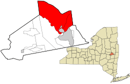 Location in Schenectady County and the state of New York. | |
| Coordinates: 42°55′45″N 74°3′7″W / 42.92917°N 74.05194°W | |
| Country | United States |
| State | New York |
| County | Schenectady |
| Area | |
| • Total | 50.7 sq mi (131.3 km2) |
| • Land | 49.2 sq mi (127.4 km2) |
| • Water | 1.5 sq mi (3.9 km2) |
| Elevation | 715 ft (218 m) |
| Population (2010) | |
| • Total | 29,480 |
| • Density | 580/sq mi (220/km2) |
| Time zone | Eastern (EST) (UTC-5) |
| • Summer (DST) | EDT (UTC-4) |
| ZIP code | 12302, 12325 |
| Area code(s) | 518 |
| Website |
www |
Glenville is a town in Schenectady County, New York, United States. It was incorporated in 1821. As of the 2010 census, the town population was 29,480.[1]
Including the village of Scotia, the town of Glenville is that part of Schenectady County north of the Mohawk River.
History
Glenville is named after Alexander Lindsay Glen. Glen, who was a native of Scotland, acquired a large tract of land in the area in the 1650s.[2][3] He named his manor at Scotia after his native country.[3]
The Seeley Farmhouse was listed on the National Register of Historic Places in 1978, the Swart House and Tavern in 2007 and the Bishop Family Lustron House was listed the following year.[4] The Glenville District No. 5 Schoolhouse was listed in 2013.[5]
Geography
According to the United States Census Bureau, the town has a total area of 50.7 square miles (131.3 km2), of which 49.2 square miles (127.4 km2) is land and 1.5 square miles (3.9 km2), or 2.94%, is water.[6]
Demographics
| Historical population | |||
|---|---|---|---|
| Census | Pop. | %± | |
| 1820 | 2,514 | — | |
| 1830 | 2,494 | −0.8% | |
| 1840 | 3,068 | 23.0% | |
| 1850 | 3,409 | 11.1% | |
| 1860 | 3,192 | −6.4% | |
| 1870 | 2,973 | −6.9% | |
| 1880 | 2,746 | −7.6% | |
| 1890 | 2,468 | −10.1% | |
| 1900 | 3,010 | 22.0% | |
| 1910 | 5,201 | 72.8% | |
| 1920 | 7,036 | 35.3% | |
| 1930 | 12,069 | 71.5% | |
| 1940 | 13,343 | 10.6% | |
| 1950 | 17,912 | 34.2% | |
| 1960 | 25,707 | 43.5% | |
| 1970 | 28,969 | 12.7% | |
| 1980 | 28,519 | −1.6% | |
| 1990 | 28,771 | 0.9% | |
| 2000 | 28,183 | −2.0% | |
| 2010 | 29,480 | 4.6% | |
| Est. 2014 | 29,666 | [7] | 0.6% |
As of the census of 2000, there were 28,183 people, 11,150 households, and 7,827 families residing in the town. The population density was 565.0 people per square mile (218.2/km²). There were 11,582 housing units at an average density of 232.2 per square mile (89.7/km²). The racial makeup of the town was 97.35% White, 0.72% African American, 0.12% Native American, 0.89% Asian, 0.02% Pacific Islander, 0.14% from other races, and 0.75% from two or more races. Hispanic or Latino of any race were 1.20% of the population.
There were 11,150 households out of which 30.9% had children under the age of 18 living with them, 59.0% were married couples living together, 8.4% had a female householder with no husband present, and 29.8% were non-families. 26.0% of all households were made up of individuals and 12.5% had someone living alone who was 65 years of age or older. The average household size was 2.44 and the average family size was 2.95.
In the town the population was spread out with 23.7% under the age of 18, 5.0% from 18 to 24, 26.3% from 25 to 44, 26.1% from 45 to 64, and 18.9% who were 65 years of age or older. The median age was 42 years. For every 100 females there were 91.9 males. For every 100 females age 18 and over, there were 86.8 males.
The median income for a household in the town was $52,373, and the median income for a family was $62,599. Males had a median income of $42,992 versus $29,228 for females. The per capita income for the town was $24,795. 4.1% of the population and 2.5% of families were below the poverty line. Out of the total people living in poverty, 5.2% are under the age of 18 and 4.2% are 65 or older.
Communities and locations in Glenville
- Alplaus – A hamlet in the eastern part of the town.
- Hoffmans – A small settlement along Route 5, in the western portion of Glenville, marking the spot of the first ferry crossing of the Mohawk River in Glenville.
- East Glenville – A cluster of dense development along Route 50 in the northeastern section of town.
- Scotia – The Village of Scotia lies in the south part of the town.
- Stoodley Corners – More commonly referred to as the "Town Center," marking Glenville's commercial core around the intersection of Route 50 and Glenridge Road.
- West Glenville – A small hamlet in the northwestern portion of town that dates to the early 19th century.
Economy
The town of Glenville is regarded as a bedroom community, with many residents finding employment at General Electric in adjacent Schenectady, various New York state offices in nearby Albany, and numerous Capital District corporations, educational institutions, and health care industries.
Education and recreation
The town is split among three public school districts; Scotia-Glenville, Burnt Hills-Ballston Lake, and Niskayuna. Glenville is also home to several parks and preserves.
Transportation
Mohawk Valley Airport is located three nautical miles (6 km) northwest of the central business district of Scotia.[9][10] Schenectady County Airport is a joint civil-military airport located two nautical miles (3 km) north-northeast of Scotia.
References
- ↑ "Profile of General Population and Housing Characteristics: 2010 Demographic Profile Data (DP-1): Glenville town, Schenectady County, New York". U.S. Census Bureau, American Factfinder. Retrieved July 3, 2012.
- ↑ "Chapter V: The Township of Glenville". History of the City and County of Schenectady, New York. Schenectady County Public Library. 1913.
- 1 2 Village of Scotia History
- ↑ National Park Service (2009-03-13). "National Register Information System". National Register of Historic Places. National Park Service.
- ↑ "National Register of Historic Places Listings". Weekly List of Actions Taken on Properties: 05/19/13 through 05/23/13. National Park Service. 2014-05-30.
- ↑ "Geographic Identifiers: 2010 Demographic Profile Data (G001): Glenville town, Schenectady County, New York". U.S. Census Bureau, American Factfinder. Retrieved July 3, 2012.
- ↑ "Annual Estimates of the Resident Population for Incorporated Places: April 1, 2010 to July 1, 2014". Retrieved June 4, 2015.
- ↑ "Census of Population and Housing". Census.gov. Archived from the original on May 11, 2015. Retrieved June 4, 2015.
- ↑ "FAA Airport Master Record" (PDF). Federal Aviation Administration. 7 May 2009.
- ↑ "Mohawk Valley Airpark (K13)" (PDF). New York State Department of Transportation.
External links
Municipalities and communities of Schenectady County, New York, United States | ||
|---|---|---|
| City |  | |
| Towns | ||
| Villages | ||
| CDPs | ||
| Other hamlets | ||