Washington, Georgia
| Washington, Georgia | |
|---|---|
| City | |
|
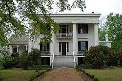
Robert Toombs House State Historic Site | |
 Location in Wilkes County and the state of Georgia | |
| Coordinates: 33°44′7″N 82°44′29″W / 33.73528°N 82.74139°WCoordinates: 33°44′7″N 82°44′29″W / 33.73528°N 82.74139°W | |
| Country | United States |
| State | Georgia |
| County | Wilkes |
| Area | |
| • Total | 7.8 sq mi (20.3 km2) |
| • Land | 7.8 sq mi (20.3 km2) |
| • Water | 0 sq mi (0 km2) |
| Elevation | 607 ft (185 m) |
| Population (2000) | |
| • Total | 4,295 |
| • Density | 550.6/sq mi (211.6/km2) |
| Time zone | Eastern (EST) (UTC-5) |
| • Summer (DST) | EDT (UTC-4) |
| ZIP code | 30673 |
| Area code(s) | 706/762 |
| FIPS code | 13-80704[1] |
| GNIS feature ID | 0356620[2] |
| Website | www.cityofwashingtonga.gov/ |
Washington (originally called Heard's Fort) is a city in Wilkes County, Georgia, United States. The population was 4,295 at the 2000 census. The city is the county seat of Wilkes County.[3] The city is often referred to as Washington-Wilkes by locals, distinguishing it from any other Washington in the United States.
Washington has a number of restored antebellum, Victorian, and colonial homes along the narrow, tree-lined streets. It claims to have more antebellum homes per capita than any other city of its size in Georgia. Several sites in Washington are on the National Register of Historic Places, including the Wilkes County Courthouse, the Robert Toombs State Historic Site, and the Mary Willis Library, known for its Victorian architecture and original Tiffany stained glass windows,[4] and for being the first free public library in the state.[4]
Also on the list are The Washington-Wilkes Historical Museum,[5] and the recently restored historic Fitzpatrick Hotel, built in 1898.[6]
Revolutionary Washington
The Battle of Kettle Creek, one of the most important battles of the American Revolutionary War to be fought in Georgia, was fought on February 14, 1779 in Wilkes County, about eight miles (13 km) from present day Washington. The battle resulted in a victory for the American Patriots who took 75 prisoners, and killed roughly 70 Loyalists, while losing 32 men.
Washington in the Civil War
Although no major battles of the Civil War were fought in or near Washington, the city has the distinction of being the location where Jefferson Davis held the last meeting with the Confederate cabinet. On April 3, 1865, with Union troops under Ulysses S. Grant poised to capture Richmond, Jefferson Davis escaped for Danville, Virginia, together with the Confederate cabinet. After leaving Danville, and continuing south, Davis met with his Confederate Cabinet for the last time on May 5, 1865 in Washington, along with a hand-picked escort led by Given Campbell, including his personal Body Guard Sgt. Joseph A Higgenbotham, Jr., of Amherst/Nelson County, Virginia. The meeting took place at the Heard house[7] (the Georgia Branch Bank Building), with fourteen officials present.
Confederate Gold
One of Washington's most lingering mysteries is that of the lost Confederate gold.[8] As the last recorded location of the remaining Confederate gold, the Washington area is thought to be the site where it is buried. Worth roughly $100,000 when it disappeared in 1865, at 2016 prices it's value would be around $3.6 million dollars. The cable television channel A&E produced a documentary focusing on this legend.
Washington's list of "firsts"
The city of Washington claims to be first in many historical events:
- First Catholic parish 1790
- First city in the nation to be established in the name of George Washington, 1780
- First Baptist church in upper Georgia at Fishing Creek, 1783[9]
- First Methodist church in Georgia was organized at Grant's Meeting House[10] in Wilkes County, 1787[11]
- First Presbyterian minister ordained in Georgia was John Springer in Wilkes County, 1790[12]
- First Episcopal conference not under the Church of England, 1788
- First successful cotton gin perfected and set up by Eli Whitney in Wilkes county, 1795.
- First woman newspaper editor in U.S. was Sarah Porter Hillhouse[13] who became the editor of the Monitor in 1804 (inducted into Georgia Women of Achievement in 2006).
- First cotton mill in Georgia erected on Upton Creek in Wilkes County, 1811
- First stamp mill for gold in the world was invented and put into use near Washington by Jeremiah Griffin, 1831–32.
- One of the first plastic garments ever cut in the world was in Wilkes County by Margo and Alfred Moses in February 1946.
- First seat of government of the State of Georgia, 1780.
- In 1777, Wilkes County became the first county in Georgia. Washington is the county seat of Wilkes County.
Geography
Washington is located at 33°44′7″N 82°44′29″W / 33.73528°N 82.74139°W (33.735394, −82.741420).[14]
According to the United States Census Bureau, the city has a total area of 7.9 square miles (20 km2), of which, 7.8 square miles (20 km2) of it is land and 0.04 square miles (0.10 km2) of it (0.25%) is water.
Demographics
| Historical population | |||
|---|---|---|---|
| Census | Pop. | %± | |
| 1810 | 596 | — | |
| 1820 | 695 | 16.6% | |
| 1850 | 462 | — | |
| 1870 | 1,506 | — | |
| 1880 | 2,199 | 46.0% | |
| 1890 | 2,631 | 19.6% | |
| 1900 | 3,300 | 25.4% | |
| 1910 | 3,065 | −7.1% | |
| 1920 | 4,208 | 37.3% | |
| 1930 | 3,158 | −25.0% | |
| 1940 | 3,537 | 12.0% | |
| 1950 | 3,802 | 7.5% | |
| 1960 | 4,440 | 16.8% | |
| 1970 | 4,094 | −7.8% | |
| 1980 | 4,662 | 13.9% | |
| 1990 | 4,279 | −8.2% | |
| 2000 | 4,295 | 0.4% | |
| 2010 | 4,134 | −3.7% | |
| Est. 2015 | 3,981 | [15] | −3.7% |
As of the 2010 United States Census, there were 4,134 people residing in the city. The racial makeup of the city was 60.4% Black, 35.3% White, 0.1% Native American, 0.7% Asian, 0.2% from some other race and 1.7% from two or more races. 1.5% were Hispanic or Latino of any race.
As of the census[1] of 2000, there were 4,295 people, 1,778 households, and 1,162 families residing in the city. The population density was 547.5 people per square mile (211.5/km²). There were 1,974 housing units at an average density of 251.6 per square mile (97.2/km²). The racial makeup of the city was 38.04% White, 60.75% African American, 0.07% Native American, 0.30% Asian, 0.05% from other races, and 0.79% from two or more races. Hispanic or Latino of any race were 0.47% of the population.
There were 1,778 households out of which 28.4% had children under the age of 18 living with them, 37.2% were married couples living together, 24.4% had a female householder with no husband present, and 34.6% were non-families. 31.8% of all households were made up of individuals and 17.0% had someone living alone who was 65 years of age or older. The average household size was 2.36 and the average family size was 2.97.
In the city the population was spread out with 24.1% under the age of 18, 8.9% from 18 to 24, 25.7% from 25 to 44, 22.1% from 45 to 64, and 19.2% who were 65 years of age or older. The median age was 39 years. For every 100 females there were 79.3 males. For every 100 females age 18 and over, there were 72.9 males.
The median income for a household in the city was $25,667, and the median income for a family was $32,500. Males had a median income of $27,281 versus $21,230 for females. The per capita income for the city was $13,659. About 17.6% of families and 23.0% of the population were below the poverty line, including 32.7% of those under age 18 and 23.2% of those age 65 or over.
Education
Wilkes County School District
The Wilkes County School District holds pre-school to grade twelve, and consists of two elementary schools, a middle school, and a high school.[17] The district has 116 full-time teachers and over 1,858 students.[18]
- Washington-Wilkes Elementary School
- Washington-Wilkes Primary School
- Washington-Wilkes Middle School
- Washington-Wilkes Comprehensive High School
Dr. Rosemary Caddell is the Superintendent of Schools.[19]
Heard's Fort
Heard's Fort[20] was built as a stockade in 1774 by Stephen Heard. Heard's Fort was designated the Seat of Government for Georgia on February 3, 1780, a position it held until 1781.
Notable people
- Edward Porter Alexander – officer in the U.S. Army, Confederate general in the American Civil War, railroad executive
- James Osgood Andrew – bishop
- Edward McKendree Bounds – clergyman and author
- Lloyd D. Brown – United States Army Major General who commanded the 28th Infantry Division in World War II[21]
- Ernie Harwell – broadcaster for Major League Baseball, "The Voice of the Tigers"
- Hillary Lindsey – Grammy Award–winning songwriter
- Robert Toombs – first Secretary of State of the Confederacy, Confederate general in the Civil War
See also
References
- 1 2 "American FactFinder". United States Census Bureau. Retrieved 2008-01-31.
- ↑ "US Board on Geographic Names". United States Geological Survey. 2007-10-25. Retrieved 2008-01-31.
- ↑ "Find a County". National Association of Counties. Retrieved 2011-06-07.
- 1 2 "General Info". n-georgia.com. Retrieved 14 July 2011.
- ↑ http://www.kudcom.com/www/att02.html
- ↑ http://thefitzpatrickhotel.com/past-and-present/a-brief-history/
- ↑ http://www.kudcom.com/www/hpage9.html
- ↑ http://www.kudcom.com/www/gold.html
- ↑ Historical Marker
- ↑ http://www.kudcom.com/www/mark/mark15.html
- ↑ Historical Marker
- ↑ Historical Marker
- ↑ http://www.kudcom.com/www/mark/mark34hf.html
- ↑ "US Gazetteer files: 2010, 2000, and 1990". United States Census Bureau. 2011-02-12. Retrieved 2011-04-23.
- ↑ "Annual Estimates of the Resident Population for Incorporated Places: April 1, 2010 to July 1, 2015". Retrieved July 2, 2016.
- ↑ "Census of Population and Housing". Census.gov. Retrieved June 4, 2015.
- ↑ Georgia Board of Education, Retrieved June 30, 2010.
- ↑ School Stats, Retrieved June 30, 2010.
- ↑ "Wilkes County Board of Education". Wilkes County Schools. Retrieved 2012-06-16.
- ↑ http://www.kudcom.com/www/mark/mark29.html
- ↑ Associated Press, Thomasville Times Enterprise, "Maj. Gen. Lloyd Brown, Retired Army Officer, Died in Washington," February 18, 1950
External links
| Wikimedia Commons has media related to Washington, Georgia. |
- City of Washington Official Website
- Washington, Georgia Tourism web site: Washington, Georgia
- Georgia Historical Markers in Washington-Wilkes
-
 "Washington. The county-seat of Wilkes County, Ga". New International Encyclopedia. 1905.
Municipalities and communities of Wilkes County, Georgia, United States | ||
|---|---|---|
| City | 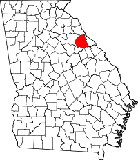 | |
| Towns | ||