Jefferson County, Georgia
| Jefferson County, Georgia | |
|---|---|
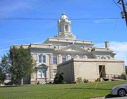 County courthouse in Louisville | |
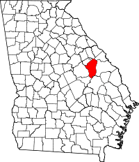 Location in the U.S. state of Georgia | |
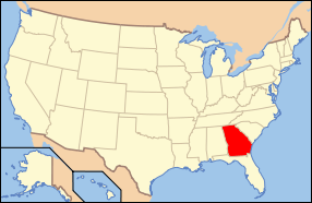 Georgia's location in the U.S. | |
| Founded | February 20, 1796 |
| Named for | Thomas Jefferson |
| Seat | Louisville |
| Largest city | Wadley |
| Area | |
| • Total | 530 sq mi (1,373 km2) |
| • Land | 526 sq mi (1,362 km2) |
| • Water | 3.2 sq mi (8 km2), 0.6% |
| Population | |
| • (2010) | 16,930 |
| • Density | 32/sq mi (12/km²) |
| Congressional district | 10th |
| Time zone | Eastern: UTC-5/-4 |
| Website | Jefferson County, Georgia |
Jefferson County is a county located in the U.S. state of Georgia. As of the 2010 census, the population was 16,930.[1] The county seat is Louisville.[2] The county was created on February 20, 1796 and named for Thomas Jefferson, the third president of the United States.[3]
Geography
According to the U.S. Census Bureau, the county has a total area of 530 square miles (1,400 km2), of which 526 square miles (1,360 km2) is land and 3.2 square miles (8.3 km2) (0.6%) is water.[4]
The small northern portion of Jefferson County, defined by a line running from Stapleton southeast and just south of State Route 80, is located in the Brier Creek sub-basin of the Savannah River basin. The entire rest of the county is located in the Upper Ogeechee River sub-basin of the Ogeechee River basin.[5]
Major highways
-
 U.S. Route 1
 -
 U.S. Route 1 Business (Louisville)
 - U.S. Route 1 Business (Wadley)
-
 U.S. Route 221
 -
 U.S. Route 319
 -
 State Route 4
 -
 State Route 4 Business (Louisville)
 - State Route 4 Business (Wadley)
-
 State Route 17
 -
 State Route 24
 -
 State Route 47
 -
 State Route 78
 -
 State Route 80
 -
 State Route 88
 -
 State Route 102
 -
 State Route 171
 -
 State Route 242
 -
 State Route 296
 -
 State Route 540 (Fall Line Freeway) (future)
Adjacent counties
- McDuffie County - north
- Richmond County - northeast
- Burke County - east
- Emanuel County - south
- Johnson County - southwest
- Glascock County - northwest
- Washington County - west
- Warren County - northwest
Demographics
| Historical population | |||
|---|---|---|---|
| Census | Pop. | %± | |
| 1800 | 5,684 | — | |
| 1810 | 6,111 | 7.5% | |
| 1820 | 7,056 | 15.5% | |
| 1830 | 7,309 | 3.6% | |
| 1840 | 7,254 | −0.8% | |
| 1850 | 9,131 | 25.9% | |
| 1860 | 10,219 | 11.9% | |
| 1870 | 12,190 | 19.3% | |
| 1880 | 15,671 | 28.6% | |
| 1890 | 17,213 | 9.8% | |
| 1900 | 18,212 | 5.8% | |
| 1910 | 21,379 | 17.4% | |
| 1920 | 22,602 | 5.7% | |
| 1930 | 20,727 | −8.3% | |
| 1940 | 20,040 | −3.3% | |
| 1950 | 18,855 | −5.9% | |
| 1960 | 17,468 | −7.4% | |
| 1970 | 17,174 | −1.7% | |
| 1980 | 18,403 | 7.2% | |
| 1990 | 17,408 | −5.4% | |
| 2000 | 17,266 | −0.8% | |
| 2010 | 16,930 | −1.9% | |
| Est. 2015 | 16,106 | [6] | −4.9% |
| U.S. Decennial Census[7] 1790-1960[8] 1900-1990[9] 1990-2000[10] 2010-2013[1] | |||
As of the 2010 United States Census, there were 16,930 people, 6,241 households, and 4,407 families residing in the county.[11] The population density was 32.2 inhabitants per square mile (12.4/km2). There were 7,298 housing units at an average density of 13.9 per square mile (5.4/km2).[12] The racial makeup of the county was 54.4% black or African American, 42.6% white, 0.4% Asian, 0.1% American Indian, 1.6% from other races, and 0.9% from two or more races. Those of Hispanic or Latino origin made up 3.1% of the population.[11] In terms of ancestry, and 26.7% were American.[13]
Of the 6,241 households, 36.0% had children under the age of 18 living with them, 41.9% were married couples living together, 23.4% had a female householder with no husband present, 29.4% were non-families, and 26.0% of all households were made up of individuals. The average household size was 2.63 and the average family size was 3.16. The median age was 38.8 years.[11]
The median income for a household in the county was $29,268 and the median income for a family was $36,980. Males had a median income of $36,284 versus $27,191 for females. The per capita income for the county was $15,165. About 19.0% of families and 26.9% of the population were below the poverty line, including 40.7% of those under age 18 and 24.8% of those age 65 or over.[14]
Education
Communities
See also
- Central Savannah River Area
- National Register of Historic Places listings in Jefferson County, Georgia
References
- 1 2 "State & County QuickFacts". United States Census Bureau. Retrieved June 23, 2014.
- ↑ "Find a County". National Association of Counties. Retrieved 2011-06-07.
- ↑ Gannett, Henry (1905). The Origin of Certain Place Names in the United States. Govt. Print. Off. p. 168.
- ↑ "US Gazetteer files: 2010, 2000, and 1990". United States Census Bureau. 2011-02-12. Retrieved 2011-04-23.
- ↑ "Georgia Soil and Water Conservation Commission Interactive Mapping Experience". Georgia Soil and Water Conservation Commission. Retrieved 2015-11-20.
- ↑ "County Totals Dataset: Population, Population Change and Estimated Components of Population Change: April 1, 2010 to July 1, 2015". Retrieved July 2, 2016.
- ↑ "U.S. Decennial Census". United States Census Bureau. Retrieved June 23, 2014.
- ↑ "Historical Census Browser". University of Virginia Library. Retrieved June 23, 2014.
- ↑ "Population of Counties by Decennial Census: 1900 to 1990". United States Census Bureau. Retrieved June 23, 2014.
- ↑ "Census 2000 PHC-T-4. Ranking Tables for Counties: 1990 and 2000" (PDF). United States Census Bureau. Retrieved June 23, 2014.
- 1 2 3 "DP-1 Profile of General Population and Housing Characteristics: 2010 Demographic Profile Data". United States Census Bureau. Retrieved 2015-12-30.
- ↑ "Population, Housing Units, Area, and Density: 2010 - County". United States Census Bureau. Retrieved 2015-12-30.
- ↑ "DP02 SELECTED SOCIAL CHARACTERISTICS IN THE UNITED STATES – 2006-2010 American Community Survey 5-Year Estimates". United States Census Bureau. Retrieved 2015-12-30.
- ↑ "DP03 SELECTED ECONOMIC CHARACTERISTICS – 2006-2010 American Community Survey 5-Year Estimates". United States Census Bureau. Retrieved 2015-12-30.
External links
- The Jefferson County Information Center Website
- The Friends of Historic Downtown Louisville Website
- The Fire House Gallery Website - Contemporary art in Jefferson County
- Videos about life in Jefferson County by Fire Team Productions
- A genealogy table for Jefferson County, Georgia <--Broken link, December 2015.
- USA Today Q&A with Jefferson County High principal Molly Howard
- The News and Farmer and Wadley Herald/ Jefferson Reporter, the county's weekly newspaper and the oldest weekly in Georgia
- The Official Jefferson County Economic Development Website
- General Wood's Fort historical marker
- Old Savannah Road historical marker
- Old Town Plantation historical marker
- Rocky Comfort Creek historical marker
- Yazoo Fraud historical marker
 |
Glascock County and Warren County | McDuffie County | Richmond County | |
| Washington County | |
Burke County | ||
| ||||
| | ||||
| Johnson County | Emanuel County |
Municipalities and communities of Jefferson County, Georgia, United States | ||
|---|---|---|
| Cities | | |
| Town | ||
| CDP | ||
| Footnotes | ‡This populated place also has portions in an adjacent county or counties | |
Template:Georgia
Coordinates: 33°03′N 82°25′W / 33.05°N 82.42°W