Urartu
| Kingdom of Urartu | ||||||||||
| Biainili[1] | ||||||||||
| ||||||||||
 Urartu, 9th–6th centuries BC. | ||||||||||
| Capital | Arzashkun Tushpa (after 832 BC) | |||||||||
| Languages | Urartian Hurrian Proto-Armenian[2] | |||||||||
| Religion | Polytheism | |||||||||
| Government | Monarchy | |||||||||
| King | ||||||||||
| • | 858-844 | Aramu | ||||||||
| • | 844-828 | Sarduri I | ||||||||
| • | 828-810 | Ishpuini | ||||||||
| • | 810-785 | Menua | ||||||||
| • | 785-753 | Argishti I | ||||||||
| • | 753-735 | Sarduri II | ||||||||
| Historical era | Iron Age, Prehistoric | |||||||||
| • | Established | 860 BC | ||||||||
| • | Disestablished | 590 BC | ||||||||
| ||||||||||
| Today part of | | |||||||||

Urartu (Armenian: Ուրարտու), also known as Kingdom of Van (Urartian: Biai, Biainili;[3] Armenian: Վանի թագավորություն, Vani t′agavorut′yun;[4] Assyrian: māt Urarṭu;[5] Babylonian: Urashtu), was an Iron Age kingdom centred on Lake Van in the Armenian Highlands. It corresponds to the biblical Kingdom of Ararat.
Strictly speaking, Urartu is the Assyrian term for a geographical region, while "kingdom of Urartu" or "Biainili lands" are terms used in modern historiography for the Urartian-speaking Iron Age state that arose in that region. The language appears in cuneiform inscriptions. It is argued on linguistic evidence that proto-Armenian came in contact with Urartian at an early date (3rd-2nd millennium BC), before the formation of the Urartian kingdom.[2][6][7][8][9]
That a distinction should be made between the geographical and the political entity was already pointed out by König (1955).[10]
The landscape corresponds to the mountainous plateau between Anatolia, Mesopotamia, the Iranian Plateau, and the Caucasus Mountains, later known as the Armenian Highlands. The kingdom rose to power in the mid-ninth century BC, but went in gradual decline and was eventually conquered by the Medes in the early sixth century BC. The heirs of Urartu are the Armenians and their successive kingdoms.[8][11][12][13]
Name
The name Urartu comes from Assyrian sources: Shalmaneser I (1263–1234 BC) recorded a campaign in which he subdued the entire territory of "Uruatri."[14][15] The Shalmaneser text uses the name Urartu to refer to a geographical region, not a kingdom, and names eight "lands" contained within Urartu (which at the time of the campaign were still disunited). "Urartu" is cognate with the Biblical "Ararat", Akkadian "Urashtu" and Armenian "Ayrarat". The Urartian toponym Biainili (or Biaineli) was adopted in the Old Armenian as Van, Վան.[16] Hence the names "Kingdom of Van" or "Vannic Kingdom".
Scholars such as Carl Ferdinand Friedrich Lehmann-Haupt (1910) believed that the people of Urartu called themselves Khaldini after the god Ḫaldi.[17] Boris Piotrovsky wrote that "the Urartians first appear in history in the 13th century B.C. as a league of tribes or countries which did not yet constitute a unitary state. In the Assyrian annals the term Uruatri (Urartu) as a name for this league was superseded during a considerable period of years by the term "land of Nairi".[18] Scholars[19][20][21] believe that Urartu is an Akkadian variation of Ararat of the Old Testament. Indeed, Mount Ararat is located in ancient Urartian territory, approximately 120 kilometres (75 mi) north of its former capital. In addition to referring to the famous Biblical mountain, Ararat also appears as the name of a kingdom in Jeremiah 51:27, mentioned together with Minni and Ashkenaz.
In the early sixth century BC, Urartu was replaced by the Armenian Orontid Dynasty. In the trilingual Behistun Inscription, carved in 521 or 520 BC[22] by the order of Darius I, the country referred to as Urartu in Assyrian is called Arminiya in Old Persian and Harminuia in the Elamite language.
Shupria (Akkadian: Armani-Subartu from the 3rd millennium BC) was part of the Urartu confederation. Later, there is reference to a district in the area called Arme or Urme, which some scholars have linked to the name of Armenia.[19][20]
Geography

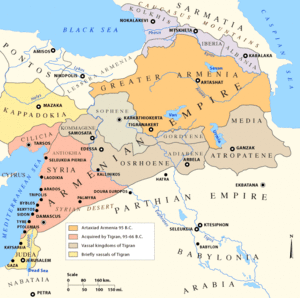
Urartu comprised an area of approximately 200,000 square miles (520,000 km2), extending from the river Kura in the north, to the northern foothills of the Taurus Mountains in the south; and from the Euphrates in the west to the Caspian sea in the east.[23]
At its apogee, Urartu stretched from the borders of northern Mesopotamia to the southern Caucasus, including present-day Armenia and southern Georgia as far as the river Kura. Archaeological sites within its boundaries include Altintepe, Toprakkale, Patnos and Haykaberd. Urartu fortresses included Erebuni (present day Yerevan city), Van Fortress, Argishtihinili, Anzaf, Haykaberd, and Başkale, as well as Teishebaini (Karmir Blur, Red Mound) and others.
Discovery


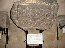
Inspired by the writings of the medieval Armenian historian Movses Khorenatsi (who had described Urartian works in Van and attributed them to the legendary Ara the Beautiful and queen Semiramis), the French scholar Jean Saint-Martin suggested that his government send Friedrich Eduard Schulz, a German professor, to the Van area in 1827 on behalf of the French Oriental Society.[24] Schulz discovered and copied numerous cuneiform inscriptions, partly in Assyrian and partly in a hitherto unknown language. Schulz also re-discovered the Kelishin stele, bearing an Assyrian-Urartian bilingual inscription, located on the Kelishin pass on the current Iraqi-Iranian border. A summary account of his initial discoveries was published in 1828. Schulz and four of his servants were murdered by Kurds in 1829 near Başkale. His notes were later recovered and published in Paris in 1840. In 1828, the British Assyriologist Henry Creswicke Rawlinson had attempted to copy the inscription on the Kelishin stele, but failed because of the ice on the stele's front side. The German scholar R. Rosch made a similar attempt a few years later, but he and his party were attacked and killed.
In the late 1840s Sir Austen Henry Layard examined and described the Urartian rock-cut tombs of Van Castle, including the Argishti chamber. From the 1870s, local residents began to plunder the Toprakkale ruins, selling its artefacts to European collections. In the 1880s this site underwent a poorly executed excavation organised by Hormuzd Rassam on behalf of the British Museum. Almost nothing was properly documented.
The first systematic collection of Urartian inscriptions, and thus the beginning of Urartology as a specialized field dates to the 1870s, with the campaign of Sir Archibald Henry Sayce. The German engineer Karl Sester, discoverer of Mount Nemrut, collected more inscriptions in 1890/1. Waldemar Belck visited the area in 1891, discovering the Rusa stele. A further expedition planned for 1893 was prevented by Turkish-Armenian hostilities. Belck together with Lehmann-Haupt visited the area again in 1898/9, excavating Toprakkale. On this expedition, Belck reached the Kelishin stele, but he was attacked by Kurds and barely escaped with his life. Belck and Lehmann-Haupt reached the stele again in a second attempt, but were again prevented from copying the inscription by weather conditions. After another assault on Belck provoked the diplomatic intervention of Wilhelm II, Sultan Abdul Hamid II, agreed to pay Belck a sum of 80,000 gold marks in reparation. During World War I, the Lake Van region briefly fell under Russian control. In 1916, the Russian scholars Nikolay Yakovlevich Marr and Iosif Abgarovich Orbeli, excavating at the Van fortress, uncovered a four-faced stele carrying the annals of Sarduri II. In 1939 Boris Borisovich Piotrovsky excavated Karmir-Blur, discovering Teišebai, the city of the god of war, Teišeba. In 1938–40, excavations by the American scholars Kirsopp and Silva Lake were cut short by World War II, and most of their finds and field records were lost when a German submarine torpedoed their ship, the SS Athenia. Their surviving documents were published by Manfred Korfmann in 1977.
A new phase of excavations began after the war. Excavations were at first restricted to Soviet Armenia. The fortress of Karmir Blur, dating from the reign of Rusa II, was excavated by a team headed by Boris Piotrovsky, and for the first time the excavators of a Urartian site published their findings systematically. Beginning in 1956 Charles A. Burney identified and sketch-surveyed many Urartian sites in the Lake Van area and, from 1959, a Turkish expedition under Tahsin Özgüç excavated Altintepe and Arif Erzen.
In the late 1960s, Urartian sites in northwest Iran were excavated. In 1976, an Italian team led by Mirjo Salvini finally reached the Kelishin stele, accompanied by a heavy military escort. The Gulf War then closed these sites to archaeological research. Oktay Belli resumed excavation of Urartian sites on Turkish territory: in 1989 Ayanis, a 7th-century BC fortress built by Rusas II of Urartu, was discovered 35 km north of Van. In spite of excavations, only a third to a half of the 300 known Urartian sites in Turkey, Iran, Iraq, and Armenia have been examined by archaeologists (Wartke 1993). Without protection, many sites have been plundered by local residents searching for treasure and other saleable antiquities.
History
Origins

Assyrian inscriptions of Shalmaneser I (c. 1274 BC) first mention Uruartri as one of the states of Nairi, a loose confederation of small kingdoms and tribal states in the Armenian Highland in the 13th to 11th centuries BC which he conquered. Uruartri itself was in the region around Lake Van. The Nairi states were repeatedly subjected to further attacks and invasions by the Assyrians, especially under Tukulti-Ninurta I (c. 1240 BC), Tiglath-Pileser I (c. 1100 BC), Ashur-bel-kala (c. 1070 BC), Adad-nirari II (c. 900), Tukulti-Ninurta II (c. 890), and Ashurnasirpal II (883–859 BC).
Urartu re-emerged in Assyrian inscriptions in the 9th century BC as a powerful northern rival of Assyria. The Nairi states and tribes became a unified kingdom under king Aramu (c. 860 – 843 BC), whose capital at Arzashkun was captured by the Assyrians under Shalmaneser III. Roughly contemporaries of the Uruartri, living just to the west along the southern shore of the Black Sea, were the Kaskas known from Hittite sources.
Growth

The temporary eclipse of Assyria in the first half of the 8th century BC had helped Urartu's growth, as it became the largest and most powerful state in the Near East, which was accomplished in little time.[25]
Sarduri I (c. 832 – 820 BC), son of king Aramu, successfully resisted the Assyrian attacks from the south, led by Shalmaneser III, consolidated the military power of the state and moved the capital to Tushpa (modern Van, on the shore of Lake Van). His son, Ispuini (c. 820 – 800 BC) annexed the neighbouring state of Musasir and made his son Sarduri II viceroy; Musasir later became an important religious center of the Urartian Kingdom. Ispuini was in turn attacked by Shamshi-Adad V. His successor Menua (c. 800 – 785 BC) also enlarged the kingdom greatly and left inscriptions over a wide area. Urartu reached the highest point of its military might under Menua's son Argishti I (c. 785 – 760 BC), becoming one of the most powerful kingdoms of ancient Near East. Argishti I added more territories along the Araxes river and Lake Sevan, and frustrated Shalmaneser IV's campaigns against him. Argishti also founded several new cities, most notably Erebuni in 782 BC. 6600 captured slaves worked on the construction of the new city.
At its height, the Urartu kingdom may have stretched North beyond the Aras River (Greek Araxes) and Lake Sevan, encompassing present-day Armenia and even the southern part of Georgia (e.g. Qulha) almost to the shores of the Black Sea; west to the sources of the Euphrates; east to present-day Tabriz, Lake Urmia, and beyond; and south to the sources of the Tigris.
Tiglath Pileser III of Assyria conquered Urartu in the first year of his reign (745 BC). There the Assyrians found horsemen and horses, tamed as colts for riding, that were unequalled in the south, where they were harnessed to Assyrian war-chariots.[26]
Decline and recuperation
In 714 BC, the Urartu kingdom suffered heavily from Cimmerian raids and the campaigns of Sargon II. The main temple at Mushashir was sacked, and the Urartian king Rusa I was crushingly defeated by Sargon II at Lake Urmia. He subsequently committed suicide in shame.[27]
Rusa's son Argishti II (714 – 685 BC) restored Urartu's position against the Cimmerians, however it was no longer a threat to Assyria and peace was made with the new king of Assyria Sennacherib in 705 BC. This in turn helped Urartu enter a long period of development and prosperity, which continued through the reign of Argishti's son Rusa II (685–645 BC).
After Rusa II, however, the Urartu grew weaker under constant attacks from Cimmerian and Scythian invaders. As a result, it became dependent on Assyria, as evidenced by Rusa II's son Sarduri III (645–635 BC) referring to the Assyrian king Ashurbanipal as his "father."[28][29]
Fall
According to Urartian epigraphy, Sarduri III was followed by three kings—Erimena (635–620 BC), his son Rusa III (620–609 BC), and the latter's son Rusa IV (609–590 or 585 BC). Late during the 7th century BC (during or after Sarduri III's reign), Urartu was invaded by Scythians and their allies—the Medes. In 612 BC, the Median king Cyaxares the Great together with Nabopolassar of Babylon and the Scythians conquered Assyria after it had been badly weakened by civil war. The Medes then took over the Urartian capital of Van towards 585 BC, effectively ending the sovereignty of Urartu.[30] According to the Armenian tradition, the Medes helped the Armenians establish the Orontid dynasty. Many Urartian ruins of the period show evidence of destruction by fire. This would indicate two scenarios — either Media subsequently conquered Urartu, bringing about its subsequent demise, or Urartu maintained its independence and power, going through a mere dynastic change, as a local Armenian dynasty (later to be called the Orontids) overthrew the ruling family with the help of the Median army. Ancient sources support the latter version: Xenophon, for example, states that Armenia, ruled by an Orontid king, was not conquered until the reign of Median king Astyages (585– 550 BC) – long after Median invasion of the late 7th century BC.[31] Similarly, Strabo (1st century BC – 1st century AD) wrote that "[i]n ancient times Greater Armenia ruled the whole of Asia, after it broke up the empire of the Syrians, but later, in the time of Astyages, it was deprived of that great authority ..."[32]
Medieval Armenian chronicles corroborate the Greek and Hebrew sources. In particular, Movses Khorenatsi writes that Armenian prince Paruyr Skayordi helped the Median king Cyaxares and his allies conquer Assyria, for which Cyaxares recognized him as the king of Armenia, while Media conquered Armenia only much later—under Astyages.[33] It is possible that the last Urartian king, Rusa IV, had connections to the future incoming Armenian Orontids dynasty.
Urartu was destroyed in either 590 BC[34] or 585 BC.[35] By the late 6th century, Urartu had certainly been replaced by Armenia.[36]
Legacy


Little is known of what happened to the region of Urartu under the foreign rule following its fall. The most widely accepted theory is that settlers related to Phrygians, or more specifically tribes speaking a Proto-Armenian language conventionally named Armeno-Phrygian who had already settled in the western parts of the region prior to the establishment of Urartu,[37] had become the ruling elite under the Median Empire, followed by the Achaemenid Empire.[38] These Armeno-Phrygians would have mingled with the disparate peoples of Urartu, resulting a fusion of languages and cultures. They multiplied in numbers and spread their language throughout the territory of Urartu. The Urartians, during its dominance, had amalgamated disparate tribes, each of which had its own culture and traditions. Thus, when the political structure was destroyed, little remained that could be identified as one unified Urartian culture.[39]
The region formerly known as Urartu became the Satrapy of Armenia under the Achaemenids,[40] which later became an independent kingdom, the Kingdom of Armenia. The Urartians who were in the satrapy were then assimilated, becoming part of the Armenian ethnogenesis.[41] However, other Urartians might have kept their former identity. According to Herodotus, the Alarodians (Alarodioi)—believed to be Urartian remnants—were part of the 18th Satrapy of the Achaemenid Empire and formed a special contingent in the grand army of Xerxes I.[42] Some Urartian traditions, such as architecture and dam constructions, were absorbed in the following Persianate societies,[43] and most probably persisted in the Satrapy of Armina. Urartu did not give birth to a direct successor, however, the Satrapy of Armina, as an entity which emerged immediately after its fall, inherited its cultural, traditional, geographical and some linguistic aspects. Darius I, in his famous Behistun Inscription, calls the region Armina/Armenia in Old Persian and Urashtu/Urartu in Babylonian, clearly equating the two, suggesting that both are somewhat part of a same continuous entity. As the Armenian identity developed in the region, the memory of Urartu faded and finally disappeared.[44]
The language spoken in Urartu is now extinct. Little is known of what was spoken in the geopolitical region from the time of Urartu's fall in the sixth century BC to the creation of the Armenian alphabet in the 4th century AD. In ancient Persian inscriptions, references to Armina (Armenia) indicate that Urartian was still spoken, or was in a transitional period into being replaced with the Armenian language. In fact, the ethnonym "Armina" itself and all other names attested with reference to the rebellions against Darius in Armina (the proper names Araxa, Haldita, and Dādṛšiš, the toponyms Zūzahya, Tigra, and Uyamā, and the district name Autiyāra) are not connected with Armenian linguistic and onomastic material attested later in native Armenian sources. They are also not Iranian, but seem related to Urartian.[45]
The name of the province of Ayrarat in the Kingdom of Armenia is believed to be a continuum of the Urartu toponym (or biblical Ararat).[46] The modern name of Mount Ararat is derived from the biblical Mountains of Ararat (or Mountains of Urartu), and the Ararat Province of modern Armenia is in turn named after the mountain.
Economy and politics
The economic structure of Urartu was similar to other states of the Ancient World, especially to Assyria. The state was heavily dependent on agriculture, which required a centralized effort to irrigation. These works managed by kings, in their implementation participated the free inhabitants, and perhaps the prisoners as slaves. Royal governors, influent people and, perhaps, free peoples have their own allotments. Individual territories within the state had to pay taxes the central government grain, horses, bulls, etc. In peacetime, Urartu probably led an active trade with Assyria, providing cattle, horses, iron and wine.
 |
 |
 | ||
| Part of iron pitchfork, found near Lake Van and Iron plowshare, found during excavations in Rusahinili (Toprakkale). | Urartian saddle quern | |||
According to archaeological data, farming on the territory of Urartu began to develop since the Neolithic period, even in the 3rd millennium BC. In the Urartian age agriculture was well developed and closely related to the Assyrian on the selection of cultures and methods of processing.[47] From cuneiform sources, it is known that in Urartu grew wheat, barley, sesame, millet and emmer, and cultivated gardens and vineyards. Many regions of the Urartu state required artificial irrigation, which has successfully been organized by the rulers of Urartu in the heyday of the state. In several regions remain ancient irrigation canals, constructed by Urartu, mainly during the Argishti I and Menua period, some of which are still used for irrigation.
Art and architecture

There is a number of remains of sturdy stone architecture, as well as some mud brick, especially when it has been burnt, which helps survival. Stone remains are mainly fortresses and walls, with temples and mausolea, and many rock-cut tombs. The style, which developed regional variations, shows a distinct character, partly because of the greater use of stone compared to neighbouring cultures. The typical temple was square, with stones walls as thick as the open internal area but using mud brick for the higher part. These were placed at the highest point of a citadel and from surviving depictions were high, perhaps with gabled roofs; their emphasis on verticality has been claimed as an influence of later Christian Armenian architecture.[48]
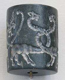
The art of Urartu is especially notable for fine lost-wax bronze objects: weapons, figurines, vessels including grand cauldrons that were used for sacrifices, fittings for furniture, and helmets. There are also remains of ivory and bone carvings, frescos, cylinder seals and of course pottery. In general their style is a somewhat less sophisticated blend of influences from neighbouring cultures. Archaeology has produced relatively few examples of the jewellery in precious metals that the Assyrians boasted of carrying off in great quantities from Musasir in 714 BC.[48]
Religion

With the expansion of Urartian territory, many of the gods worshiped by conquered peoples were incorporated into the Urartian pantheon, as a means of confirming the annexation of territories and promoting political stability. However, although the Urartians incorporated many deities into their pantheon, they appeared to be selective in their choices. Although many Urartian kings made conquests in the North, such as the Lake Sevan region, many of those peoples' gods remain excluded. This was most likely the case because Urartians considered the people in the North to be barbaric, and disliked their deities as much as they did them. Good examples of incorporated deities however are the goddesses Bagvarti (Bagmashtu) and Selardi. On Mheri-Dur, or Meher-Tur (the "Gate of Mehr"), overlooking modern Van, Turkey, an inscription lists a total of 79 deities, and what type of sacrificial offerings should be made to each; goats, sheep, cattle, and other animals served as the sacrificial offerings. Urartians did not practice human sacrifice.[49]
The pantheon was headed by a triad made up of Ḫaldi (the supreme god), Theispas (Teisheba, god of thunder and storms, as well as sometimes war), and Shivini (a solar god). Their king was also the chief-priest or envoy of Khaldi. Some temples to Khaldi were part of the royal palace complex, while others were independent structures.
Some main gods and goddesses include:[50]
Language
Urartian, the language used in the cuneiform inscriptions of Urartu, was an ergative-agglutinative language, which belongs to neither the Semitic nor the Indo-European families but to the Hurro-Urartian family. It survives in many inscriptions found in the area of the Urartu kingdom, written in the Assyrian cuneiform script. There are also claims of autochthonous Urartian hieroglyphs, but this remains uncertain.[51] According to many researchers about Urartu language, its link to North-East Caucasian languages is rather certain.[52][53][54]
The Urartians originally would have used these locally developed hieroglyphs (undeciphered and possibly not even true writing) but later adapted the Assyrian cuneiform script for most purposes. After the 8th century BC, the hieroglyphic script was restricted to religious and accounting purposes. Examples of Urartian written language have survived in many inscriptions found throughout the area of the Urartu kingdom.
Urartian cuneiform inscriptions are divided into two groups. A minority is written in Akkadian (the official language of Assyria). However, the bulk of the cuneiforms are written in an agglutinative language, conventionally called Urartian, Khaldian, or neo-Hurrian, which was related to Hurrian in the Hurro-Urartian family, and was neither Semitic nor Indo-European.
Unlike the cuneiform inscriptions, Urartian hieroglyphic "texts" have not been successfully deciphered. As a result, scholars disagree as to what language is used in the "texts", or whether they even constitute writing at all.
Armenian ethnogenesis
The Iron Age state of Urartu was the successor of the Late Bronze Age Mitanni state of the Hurrians, and the Urartian language spoken by the ruling class was the successor of the Hurrian language (see Hurro-Urartian languages).[55][56]
Urartu was in turn succeeded in the area in the sixth century BCE by the Indo-European-speaking Orontid Dynasty.[57] The presence of a proto-Armenian-speaking population in the area already during Urartian rule is subject to speculation.
It is generally assumed that proto-Armenian speakers entered Anatolia from around 1200 BCE, ultimately deriving from a Paleo-Balkans context, and over the following centuries spread east to the Armenian Highlands.[58][59][60]
A competing theory suggested by Tamaz V. Gamkrelidze and Vyacheslav V. Ivanov in 1984 places the Proto-Indo-European homeland in the Armenian Highlands, see Armenian hypothesis, which would entail the presence of proto-Armenians in the area during the entire lifetime of the Urartian state.[61] According to historian M. Chahin, "Urartian history is part of Armenian history, in the same sense that the history of the ancient Britons is part of English history, and that of the Gauls is part of French history. Armenians can legitimately claim, through Urartu, an historical continuity of some 4000 years; their history is among those of the most ancient peoples in the world."[8]
After the disappearance of Urartu as a political entity at the hands of Assyria, the Armenians eventually came to dominate the highlands after the fall of the Neo-Assyrian Empire, absorbing portions of the previous Urartian culture in the process. The Armenians became, thus, the direct successors of the kingdom of Urartu and inherited their domain.
While the Urartian language was spoken by the royal elite, the population they ruled may have been multi-ethnic, and in late Urartian times largely (pre-Proto-) Armenian-speaking.[6] Under this theory, the Armenian-speaking population were the descendants of the proto-Armenians who migrated to the Armenian Highlands in c. the seventh century BCE, mixing with the local Hurrian-speaking population (i.e. the "Phrygian theory," first suggested by Herodotus).
A minority belief, advocated primarily by the official historiography of Armenia, but also supported by experts in Assyrian and Urartian studies such as Igor M. Diakonoff, Giorgi Melikishvili, Mikhail Nikolsky, Ivan Mestchaninov, suggests that Urartian was solely the formal written language of the state, while its inhabitants, including the royal family, spoke Armenian.[58] This theory primarily hinges on the language the Urartian cuneiform inscriptions being very repetitive and scant in vocabulary (having as little as 350–400 roots). Furthermore, over 250 years of usage, it shows no development, which is taken to indicate that the language had ceased to be spoken before the time of the inscriptions or was used only for official purposes.[58] This belief is compatible with the "Armenian hypothesis" suggested by Vyacheslav Ivanov and Gamkrelidze in 1984, postulating the Armenian language as an in situ development of a 3rd millennium BC Proto-Indo-European language.[61]
According to the Encyclopedia of Indo-European Culture:
The Armenians according to Diakonoff, are then an amalgam of the Hurrian (and Urartians), Luvians and the Proto-Armenian Mushki who carried their IE [Indo European] language eastwards across Anatolia. After arriving in its historical territory, Proto-Armenian would appear to have undergone massive influence on part the languages it eventually replaced. Armenian phonology, for instance, appears to have been greatly affected by Urartian, which may suggest a long period of bilingualism.[62]
The discovery of Urartu has come to play a significant role in 19th and 20th-century Armenian nationalism.[63]
See also
- Economy of Urartu
- Armenia
- Mount Ararat
- Ara the Beautiful
- Proto-Armenian language
- Chaldia
- Hurro-Urartian languages
- List of kings of Urartu
- Nakh-Daghestanian Languages
References
Footnotes
- ↑ Paul Zimansky, "Urartian material culture as state assemblage", Bulletin of the American Association of Oriental Research 299 (1995), 105.
- 1 2 Diakonoff, Igor M (1992). "First Evidence of the Proto-Armenian Language in Eastern Anatolia". Annual of Armenian Linguistics. 13: 51–54. ISSN 0271-9800.
- ↑ Hewsen, Robert H. (2000), "'Van in This World; Paradise in the Next': The Historical Geography of Van/Vaspurakan", in Hovannisian, Richard G., Armenian Van/Vaspurakan , Historic Armenian Cities and Provinces , Costa Mesa, California: Mazda Publishers , p. p. 13, OCLC 44774992
- ↑ A.Y.Movsisyan, «The hieroglyphic script of van kingdom (Biainili, Urartu, Ararat)», Publishing House «Gitutyun» of NAS RA, Yerevan 1998. (Առկա է ՀՀ Ազգային Գրադարանում, ծածկագիր՝ 9(47.925)/Մ-91)
- ↑ Eberhard Schrader, The Cuneiform inscriptions and the Old Testament (1885), p. 65.
- 1 2 Róna-Tas, András.Hungarians and Europe in the Early Middle Ages: An Introduction to Early Hungarian History. Budapest: Central European University Press, 1999 p. 76 ISBN 963-9116-48-3.
- ↑ Greppin, John A. C. (1991). "Some Effects of the Hurro-Urartian People and Their Languages upon the Earliest Armenians". Journal of the American Oriental Society. 3 (4): 720–730. doi:10.2307/603403.
Even for now, however, it seems difficult to deny that the Armenians had contact, at an early date, with a Hurro-Urartian people.
- 1 2 3 Chahin, M. (2001). The kingdom of Armenia: a history (2. rev. ed.). Richmond: Curzon. p. 182. ISBN 0700714529.
- ↑ Scarre, edited by Chris (2013). Human past : world prehistory and the development of human societies. (3rd ed.). W W Norton. ISBN 0500290636.
- ↑ F. W. König, Handbuch der chaldischen Inschriften (1955).
- ↑ Frye, Richard N. (1984). The History of Ancient Iran. Munich: C.H. Beck. p. 73. ISBN 3406093973.
The real heirs of the Urartians, however, were neither the Scythians nor Medes but the Armenians.
- ↑ Redgate, A. E. (2000). The Armenians. Oxford: Blackwell. p. 5. ISBN 0631220372.
However, the most easily identifiable ancestors of the later Armenian nation are the Urartians.
- ↑ Lang, David Marshall (1980). Armenia: Cradle of Civilization (3 ed.). London: Allen & Unwin. pp. 85–111. ISBN 0049560093.
- ↑ Abram Rigg Jr., Horace. "A Note on the Names Armânum and Urartu". Journal of the American Oriental Society, 57/4 (Dec., 1937), pp. 416–418.
- ↑ Zimansky, Paul E. Ancient Ararat: A Handbook of Urartian Studies. Delmar, NY: Caravan Books, 1998, p. 28. ISBN 0-88206-091-0.
- ↑ I. M. Diakonoff, "Hurro-Urartian Borrowings in Old Armenian". Journal of the American Oriental Society, 105/4 (Oct.–Dec. 1985), p. 601.
- ↑ Lehmann-Haupt, C. F. Armenien. Berlin: B. Behr, 1910-31.
- ↑ Piotrovsky, Boris B. The Ancient Civilization of Urartu. New York: Cowles Book Co., Inc., 1969, 51.
- 1 2 Lang, David Marshall. Armenia: Cradle of Civilization. London: Allen and Unwin, 1970, p. 114. ISBN 0-04-956007-7.
- 1 2 Redgate, Anna Elizabeth. The Armenians. Cornwall: Blackwell, 1998, pp. 16–19, 23, 25, 26 (map), 30–32, 38, 43 ISBN 0-631-22037-2.
- ↑ Ararat (WebBible Encyclopedia) – ChristianAnswers.Net
- ↑ Skjaervo, Prods Oktor, "An Introduction to Old Persian", Harvard 2002
- ↑ Chahin. The Kingdom of Armenia, p. 105.
- ↑ Lynch, H.F.B. Armenia, Travels and Studies, Volume 2. London: Longmans, 1901, p. 54.
- ↑ Urartian Material Culture As State Assemblage: An Anomaly in the Archaeology of Empire, Paul Zimansky, Page 103 of 103-115
- ↑ D.D. Luckenbill, Ancient Records of Assyria and Babylonia, (1927, vol II:84), quoted in Robin Lane Fox, Travelling Heroes in the Epic Age of Homer (2008:17).
- ↑ Georges Roux - Ancient Iraq page 314
- ↑ Journal of Ancient History 1951, No 3. Pages. 243–244
- ↑ Letter of Ashubanipal to Sarduri III. HABL, № 1242.
- ↑ Kurdoghlian, Mihran (1994). Badmoutioun Hayots, Volume I (in Armenian). Hradaragoutioun Azkayin Oussoumnagan Khorhourti. pp. 46–48.
- ↑ Xenophon.Cyropedia. 3.7. Translated by Henry Graham Dakyns.
- ↑ Strabo. Geography. 11.3.5.
- ↑ (Armenian) Movses Khorenatsi. Հայոց Պատմություն, Ե Դար [History of Armenia, Fifth Century]. Annotated translation and commentary by Stepan Malkhasyants, ed. Gagik Sargsyan. Yerevan: Hayastan Publishing, 1997, I.21, pp. 100–101. ISBN 5-540-01192-9.
- ↑ Urartu – Lost Kingdom of Van
- ↑ Urartu civilization – All About Turkey
- ↑ Van de Mieroop, Marc. A History of the Ancient Near East c. 3000 – 323 BC. Cornwall: Blackwell, 2006, p. 205. ISBN 1-4051-4911-6.
- ↑ Uchicago.edu
- ↑ Redgate, Anne Elizabeth (2000). The Armenians. Wiley. ISBN 978-0-631-22037-4., p. 50
- ↑ Armen Asher The Peoples of Ararat. 2009, p. 290-291. ISBN 978-1-4392-2567-7.
- ↑ Livius.org
- ↑ Diakonov, I. The Pre-history of the Armenian People. Delmar, NY: Caravan Books, 1984.
- ↑ Lang, pp. 112, 117
- ↑ Kleiss, Wolfram. "URARTU IN IRAN". Encyclopædia Iranica. Retrieved 2012-09-03.
- ↑ Armen Asher The Peoples of Ararat. 2009, p. 291. ISBN 978-1-4392-2567-7.
- ↑ Schmitt, R. "ARMENIA and IRAN i. Armina, Achaemenid province". Encyclopædia Iranica. Retrieved 2012-09-03.
- ↑ Hewsen, R. H. "AYRARAT". Encyclopædia Iranica. Retrieved 2012-09-03.
- ↑ Piotrovskii, Boris, B. Ванское царство (Урарту), Moscow: Vostochnoy Literaturi Publishing, 1959.
- 1 2 C. A. Burney, "Urartian." Grove Art Online, Oxford Art Online. Oxford University Press, accessed December 30, 2012, online, subscription required
- ↑ Chahin, Mark (1987). The Kingdom of Armenia. Dorset Press. ISBN 0-88029-609-7.
- ↑ Piotrovsky, Boris B. (1969). The Ancient Civilization of Urartu: An Archaeological Adventure. Cowles Book Co. ISBN 0-214-66793-6.
- ↑ Sayce, Archibald H. "The Kingdom of Van (Urartu)" in Cambridge Ancient History. Cambridge: Cambridge University Press, 1982, vol. 3, p. 172. See also C. F. Lehman-Haupt, Armenien Einst und Jetzt, Berlin, 1931, vol. 2, p. 497.
- ↑ Vyacheslav V. Ivanov, Comparative Notes on Hurro-Urartian, Northern Caucasian and Indo-European, http://www.pies.ucla.edu/IESV/1/VVI_Horse.pdf
- ↑ Sergei A. Starostin: Igor M. Diakonoff, Hurro-Urartian as an Eastern Caucasian Language. Munich: R. Kitzinger, 1986.
- ↑ Greppin, JAC, The Urartian Substratum in Armenian, http://www.science.org.ge/2-2/Grepin.pdf, 2008.
- ↑ Diakonoff, Igor M.; Starostin, Sergei (1986). Hurro-Urartian as an Eastern Caucasian Language. R. Kitzinger. ISBN 978-3-920645-39-1.
- ↑ Piotrovskij, Boris Borisovich (1969). The ancient civilization of Urartu. Cowles Book Co.
- ↑ Urartu on Britannica
- 1 2 3 (Armenian) Katvalyan, M. and Karo Ghafadaryan. «Ուրարտու» [Urartu]. Armenian Soviet Encyclopedia. Yerevan: Armenian Academy of Sciences, 1986, vol. 12, pp. 276–283.
- ↑ Dyakonov, I.M., V.D. Neronova, and I.S. Sventsitskaya. History of the Ancient World. vol. ii, Moscow, 1983.
- ↑ Samuelian, Thomas J. (2000). Armenian origins: an overview of ancient and modern sources and theories. Iravunq Pub. House.
- 1 2 Gamkrelidze, Tamaz V.; Ivanov, Vyacheslav (1995). Indo-European and the Indo-Europeans: A Reconstruction and Historical Analysis of a Proto-Language and Proto-Culture. Part I: The Text. Part II: Bibliography, Indexes. Walter de Gruyter. ISBN 978-3-11-081503-0.
- ↑ "Armenians" in Adams, Douglas Q. (1997). Encyclopedia of Indo-European Culture. Taylor & Francis. ISBN 978-1-884964-98-5.
- ↑ Redgate, Anne Elizabeth (2000). The Armenians. Wiley. ISBN 978-0-631-22037-4., p. 276.
Literature
- Ashkharbek Kalantar, Materials on Armenian and Urartian History (with a contribution by Mirjo Salvini), Civilisations du Proche-Orient: Series 4 – Hors Série, Neuchâtel, Paris, 2004;ISBN 978-2-940032-14-3
- Boris B. Piotrovsky, The Ancient Civilization of Urartu (translated from Russian by James Hogarth), New York:Cowles Book Company, 1969.
- M. Salvini, Geschichte und Kultur der Urartäer, Darmstadt 1995.
- R. B. Wartke, Urartu — Das Reich am Ararat In: Kulturgeschichte der Antiken Welt, Bd. 59, Mainz 1993.
- P. E. Zimansky, Ecology and Empire: The Structure of the Urartian State, [Studies in Ancient Oriental Civilization], Chicago: Oriental Institute, 1985.
- P. E. Zimansky, Ancient Ararat. A Handbook of Urartian Studies, New York 1998.
External links
| Wikimedia Commons has media related to Urartu. |
- Livius History of Urartu/Armenia
- Historical Maps of Urartu at WikiMedia Commons
- An Urartian Ozymandias – article by Paul Zimansky, Biblical Archaeologist
- Urartu Civilization
- Urartu (Greek Ararat)
- Capital and Periphery in the Kingdom of Urartu, Yehuda Dagan, Israel Antiquities Authority
Urartu topics | ||
|---|---|---|
| Language |  Urartu (Ararat) at its greatest expanse, ca. 743 BC | |
| Kings | ||
| Cities and Fortresses | ||
| Mythology | ||
Historical states and regions of Armenia | ||
|---|---|---|
| Independent Armenian states |
|  |
| Minor or dependent Armenian states |
| |
| Provinces or Ashkhars of Armenia Major | ||
| Other Armenian regions |
| |
| Other provinces under Tigranes the Great | ||
Coordinates: 38°00′00″N 43°00′00″E / 38.0000°N 43.0000°E