Roxboro, North Carolina
| Roxboro, North Carolina | |
|---|---|
| City | |
|
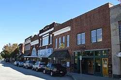
Main Street downtown | |
| Motto: Progress Is Our Business! | |
 Location of Roxboro, North Carolina | |
| Coordinates: 36°23′30″N 78°58′55″W / 36.39167°N 78.98194°WCoordinates: 36°23′30″N 78°58′55″W / 36.39167°N 78.98194°W | |
| Country | United States |
| State | North Carolina |
| County | Person |
| Government | |
| • Mayor | Merilyn P. Newell (D) |
| Area | |
| • Total | 6.3 sq mi (16.3 km2) |
| • Land | 6.3 sq mi (16.2 km2) |
| Elevation | 715 ft (218 m) |
| Population (2010) | |
| • Total | 8,362 |
| • Density | 2,426/sq mi (937.6/km2) |
| Time zone | Eastern (EST) (UTC-5) |
| • Summer (DST) | EDT (UTC-4) |
| ZIP codes | 27573, 27574 |
| Area code(s) | 336/743 |
| FIPS code | 37-58160[1] |
| GNIS feature ID | 1024281[2] |
| Website |
www |
Roxboro (/ˈrɒksbʌroʊ/ ROKS-burr-oh) is a city in and the county seat of Person County, North Carolina, United States. The population was 8,362 at the 2010 census. The city is 30 miles (48 km) north of Durham and is a part of the four-county Durham-Chapel Hill Metropolitan Statistical Area, which has a population of 504,357 as of Census 2010. The Durham–Chapel Hill MSA is a part of the larger Raleigh-Durham-Cary Combined Statistical Area, which has a population of 1,749,525 as of Census 2010.
History
Roxboro is named after a town in Scotland, Roxburgh. Although spelled differently, they are pronounced the same. Prior to the official adoption of the name Roxboro, the community was known as "Mocassin Gap". The city of Roxboro was incorporated on January 9, 1855 and remains the only municipality in Person County.
The Holloway-Jones-Day House, House on Wagstaff Farm, James A. and Laura Thompson Long House, Merritt-Winstead House, Person County Courthouse, Roxboro Commercial Historic District, Roxboro Cotton Mill, and Roxboro Male Academy and Methodist Parsonage are listed on the National Register of Historic Places.[3]
Geography
Roxboro is located at 36°23′30″N 78°58′55″W / 36.39167°N 78.98194°W (36.391690, -78.981877).[4]
According to the United States Census Bureau, the city has a total area of 6.3 square miles (16 km2), of which, 6.3 square miles (16 km2) of it is land and 0.16% is water.
Climate
Roxboro has a moderate subtropical climate, with mild weather in the spring, fall, and winter. However, summers can be hot and humid. Winter temperatures generally range from highs in the low 50s°F (10-13 °C) to lows in the upper 20s-mid 30s°F (-2 to 2 °C), though 60 °F (16 °C) degree weather is not uncommon. The record low was -9 °F in January 1985. Spring and fall days are usually in the low to mid 70s°F (low 20s°C), with nights in the 50s°F (10-14 °C). Summer days are often in the upper 80s and low 90s °F (30-35 °C,) with very high humidity. The record high was 104 °F in July 1966. The rainiest months are July and September.
Roxboro receives an average of 7.2 in (183 mm) of snow per winter. Freezing rain and sleet occur most winters, and occasionally the area experiences a major, damaging ice storm. Roxboro is often dubbed the "Snow Capital of the Triangle" due to TV news crews from Raleigh/Durham descending upon the city any time the weather forecast calls for frozen precipitation in north central North Carolina.
| Climate data for Roxboro | |||||||||||||
|---|---|---|---|---|---|---|---|---|---|---|---|---|---|
| Month | Jan | Feb | Mar | Apr | May | Jun | Jul | Aug | Sep | Oct | Nov | Dec | Year |
| Average high °F (°C) | 48.1 (8.9) |
52.2 (11.2) |
60.1 (15.6) |
70.3 (21.3) |
77.2 (25.1) |
84.4 (29.1) |
88.5 (31.4) |
86.4 (30.2) |
80.3 (26.8) |
70.6 (21.4) |
61.7 (16.5) |
51.2 (10.7) |
69.3 (20.7) |
| Average low °F (°C) | 26.2 (−3.2) |
28.3 (−2.1) |
35.4 (1.9) |
43.6 (6.4) |
52.3 (11.3) |
61.2 (16.2) |
65.5 (18.6) |
63.1 (17.3) |
56.0 (13.3) |
44.2 (6.8) |
36.5 (2.5) |
28.6 (−1.9) |
45.0 (7.2) |
| Average precipitation inches (mm) | 4.29 (109) |
3.40 (86.4) |
4.38 (111.3) |
3.32 (84.3) |
3.68 (93.5) |
3.69 (93.7) |
4.81 (122.2) |
3.96 (100.6) |
4.40 (111.8) |
3.90 (99.1) |
3.40 (86.4) |
3.40 (86.4) |
46.63 (1,184.4) |
| Average snowfall inches (cm) | 2.4 (6.1) |
1.7 (4.3) |
0.5 (1.3) |
0 (0) |
0 (0) |
0 (0) |
0 (0) |
0 (0) |
0 (0) |
0 (0) |
0.1 (0.3) |
0.5 (1.3) |
7.2 (18.3) |
| Average precipitation days (≥ 0.01 in) | 10.5 | 9.4 | 10.2 | 9.1 | 10.1 | 9.8 | 11.2 | 9.6 | 8.2 | 6.8 | 8.4 | 9.7 | 113 |
| Average snowy days (≥ 0.1 in) | 0.9 | 1.5 | 0.5 | 0 | 0 | 0 | 0 | 0 | 0 | 0 | 0.1 | 0.5 | 3.5 |
| Mean monthly sunshine hours | 164.3 | 175.2 | 229.4 | 252.0 | 257.3 | 267.0 | 260.4 | 238.7 | 219.0 | 213.9 | 174.0 | 158.1 | 2,609.3 |
| Source: Weather.com[5] | |||||||||||||
Law & government
City council
Merilyn P. Newell, Mayor
Will Davis, Mayor Pro-Tem
Mark Phillips, Councilman
Henry Daniel, Councilman
Byrd Blackwell, Councilman
Sandy Stigall, Councilman
Mayor and City Council members are elected to four-year terms on a non-partisan, at-large basis.
Crime
Current statistics
In 2009, 0 murders or non-negligent manslaughters were reported on the Federal Bureau of Investigation's Uniform Crime Reports.
Businesses
Roxboro businesses include LED lighting, law firms, electrical, textile, manufacturing, aerodynamics, administrative, winery, brokering, food processing, automotive, tobacco agriculture, aluminum and paper products. Roxboro is also adjacent to North Carolina's Research Triangle region, home to numerous high-tech companies and enterprises.
Largest employers:
- Duke Energy
- Eaton Corporation
- Georgia-Pacific Corporation
- GKN Driveline
- Person County Schools
- Person Memorial Hospital
Other businesses:
- Capital Power Corporation
- CenterEdge Software
- CertainTeed
- Dialight
- Diamond Candles
- Flue-Cured Tobacco Cooperative
- Louisiana-Pacific Corporation
- Mark Line Industries
- North American Aerodynamics, Inc
- P&A Industrial Fabrications
- Piedmont Electric Membership Corporation
- Premier Displays & Services LLC
- Spuntech Industries Inc
- StrutMasters
- Wesbell Technologies
Demographics
| Historical population | |||
|---|---|---|---|
| Census | Pop. | %± | |
| 1880 | 483 | — | |
| 1890 | 421 | −12.8% | |
| 1900 | 1,021 | 142.5% | |
| 1910 | 1,425 | 39.6% | |
| 1920 | 1,651 | 15.9% | |
| 1930 | 3,657 | 121.5% | |
| 1940 | 4,599 | 25.8% | |
| 1950 | 4,321 | −6.0% | |
| 1960 | 5,147 | 19.1% | |
| 1970 | 5,370 | 4.3% | |
| 1980 | 7,532 | 40.3% | |
| 1990 | 7,332 | −2.7% | |
| 2000 | 8,696 | 18.6% | |
| 2010 | 8,362 | −3.8% | |
| Est. 2015 | 8,334 | [6] | −0.3% |
As of the census[1] of 2010 there were 8,362 people, 3,479 households, and 1,979 families residing in the city. The population density was 1,296.2 people per square mile (535.5/km²). There were 4,044 housing units at an average density of 630.8 per square mile (243.5/km²). The racial makeup of the city was 44.9% White, 46.8% African American, 0.6% Native American, 0.4% Asian, 0.01% Pacific Islander, 2.59% from other races, and 2.1% from two or more races. Hispanic or Latino of any race were 8.7% of the population. (This reporting does not take into account the massive annual influx of Hispanic migrant labor.)
There were 3,479 households out of which 28.1% had children under the age of 18 living with them, 35.2% were married couples living together, 22.0% had a female householder with no husband present, and 38.8% were non-families. 33.8% of all households were made up of individuals and 15.2% had someone living alone who was 65 years of age or older. The average household size was 2.21 and the average family size was 2.76.
In the city the population was spread out with 23.7% under the age of 18, 8.4% from 18 to 24, 29.0% from 25 to 44, 20.8% from 45 to 64, and 18.1% who were 65 years of age or older. The median age was 44.1 years. For every 100 females there were 81.3 males. For every 100 females age 18 and over, there were 77.8 males.
The median income for a household in the city was $36,918 and the median income for a family was $42,559. Males had a median income of $27,741 versus $23,245 for females. The per capita income for the city was $17,824. About 13.4% of families and 16.8% of the population were below the poverty line, including 21.6% of those under age 18 and 14.5% of those age 65 or over.
Education
See Person County, North Carolina
Culture
Museum
- Person County Museum - The museum complex includes the Kitchen House, the Male Academy/Parsonage, Woodsdale General Store, Dr. John H. Merritt's office, a tobacco barn, and the Van Hook Subscription School, which is believed to be the oldest in the state. Exhibit featuring athletic exploits of Roxboro's own Enos Slaughter to Person County's connection with the RMS Titanic in uptown Roxboro.
Entertainment
- Palace Pointe - A multi-entertainment complex featuring eight movie screens with stadium seating, 20 bowling lanes with cosmic bowling, a roller skating rink, arcade room, diner, billiards room, along with private rooms for parties and meeting functions.
- Roxboro Motorsports Dragway - An IHRA sanctioned, 1/8 mile concrete dragstrip opened in 1960. Car, truck and bike events are the norm during the spring, summer and fall.
- Rock Sportsplex- Features five baseball fields and a batting cage.
Farmers market
- Person County Farmers Market - Locally grown produce and goods. Located in the business district.
Festivals
- Personality - A two-day festival is held in August and brings thousands to uptown. It includes street dancing, games, music, booths, food and rides.
- Lake Mayo Canoe/Kayak Festival - This one-day event is for paddlers and spectators alike. It is celebrated each spring on Lake Mayo.
- Willow Oak Blue Grass Festival - Held in June and September of each year, this park setting is the home of national, regional, and local blue grass bands. The site includes camping, food, and concessions.
- Shrimp Fest - Indulge in the delicious cuisines of endless shrimp. Shrimp Fest is usually held in May.
Events
- Clash of the Carts - The competition invites teams of amateur engineers, mechanics, performing artists, general goofballs, and others to create outrageous human powered soapbox carts to race against the clock in a two block downhill sprint to the finish line in uptown.
- Mayo Lake Cyclysm - Join over 100 cyclists on a scenic journey through rural North Carolina and Virginia. Choose between route distances of 25 km (15.5 miles), 50 km (31 miles) and a more challenging ride of 75 km (46.5 miles) for experienced cyclists. Cyclysm Bicycle Tour is usually held the third weekend of October.
- Friday Night Football - Rocket football is big in this town, a good way to end the work week with a little fun. Rocket football brings out thousands of family/friends from the community to Watch the game. Also home of Douglas Weaver, Willie Pettiford, Lamarte McGhee, Jacob Newton and other outstanding former Rocket football players
- Relay For Life - Cancer fight fund-raising event from all walks of life, including patients, medical support staff, local businesses, friends, families, corporations, civic organizations, churches and community volunteers. This yearly event is held at Person High School Stadium in late September or early October.
- Flat River Antique Engine and Tractor Show - This two-day event attracts many exhibitors and visitors with demonstrations and displays based on the rich agricultural heritage of Person County. Event held in mid September at Optimist Park.
- July 4 Parade & Fireworks - Main street is paraded with antique cars, hot rods, tractors and horse back riders. Followed by celebration of American spirit and pride. Set at the Person High School Stadium, the colorful sights and sounds are preceded by a live concert.
- Alive After 5 - Join hundreds of musical fans listen to the smooth sounds of local bands. This summer event usually held twice a year in June and July at Merritt Commons in uptown.
Performing arts
- Kirby Civic Auditorium - Entertainment in this restored historic movie theater in uptown Roxboro features live theater, dance, and concerts. Headliners have included Branford Marsalis, Doc Watson, the Embers, Mike Cross, and year-round local productions. Total seating capacity - 1028.
- Roxboro Little Theater - Producing stage entertainment for over 30 years, through the efforts of both local and regional thespians. RLT has featured such productions as "The Wizard of Oz", "Steel Magnolias", "The Sound of Music", and "Oliver".
- Merritt Commons Pavilion - Host local music acts and stage plays in uptown Roxboro.
Public library


- Person County Public Library is located in Roxboro. The library hosts over fifty programs a year for children, and an average of two programs a month for adults. There are over 26,000 library card holders.[8]
Parks and recreation
Person County Parks and Recreation Department offers a wide variety of leisure services throughout the county providing a variety of recreational opportunities including playgrounds, walking tracks, picnic shelters, basketball courts, golf course, putt-putt, bicycling, fishing, swimming, tennis courts, ball fields, volleyball courts, hiking trails, horseshoe pits and restroom facilities at more than 14 sites, more than 6,735 acres (27 km2) of park land, including:
- Huck Sansbury Recreation Complex
- Allensville Park
- Bushy Fork Park
- Hurdle Mills Park
- Optimist Park
- Longhurst Park
- Mayo Park
- Mt. Tirzah Park
- Olive Hill Park
Other attractions include:
- Rock Sportsplex - five baseball fields and a batting cage.
- Roxboro Country Club - 18-hole golf course.
- Piedmont Community College Nature Trail - A system of seven trails with an observatory. Total distance is 12,741 feet (2.4 miles).
- Hyco Lake
- Mayo Lake
- Roxboro City Lake
Shopping
- Roxboro Commons
- Roxboro Square
- Roxboro Market Place
- Person Plaza
- Piedmont Square
- Madison Corners
- Madison Square
Infrastructure
Transportation
Air
- Person County Airport located 8 miles (13 km) South of Roxboro on U.S. Route 501.
- Raleigh-Durham International Airport located 42 miles (68 km) South of Roxboro.
- Piedmont Triad International Airport located 72 miles (116 km) SW of Roxboro.
Major highways
Future East Roxboro Bypass
NCDOT approved the Eastern Roxboro Bypass - Four-lane highway from US Hwy 501 south intersection of Old Durham Road to NC Hwy. 49 north. This project has yet to get underway due to funding.
Railroad
- Norfolk Southern - Freight Rail Service
Public transit
- Person Area Transit System (PATS) operates bus routes within Roxboro.
Utilities
The city's electric system is maintained by Duke Energy and Piedmont Electric Membership Cooperative. Telephone networks - CenturyLink, wireless networks - AT&T Mobility, U.S. Cellular and Verizon Wireless. Broadband internet - CenturyLink, Electronic Solutions and Charter Communications. Cable television service is available from Charter Communications & CenturyLink.
Media
Print media
Newspapers and periodicals that serve the Roxboro and surrounding area:
Radio
Roxboro is also the city of license for two radio stations:
Other nearby stations
- W281AE 104.1 FM (.01 kW translator of Liberty University's WRVL, Lynchburg, VA)
Television
Roxboro is part of the Raleigh-Durham-Fayetteville Designated Market Area, the 24th largest broadcast television market in the United States.
- WFMY-TV from Greensboro is carried on DirecTV.
- WSET-TV from Lynchburg, Virginia is carried on Charter Cable & DirecTV.
Notable people
- Jamie Barnette, former professional American and Canadian football quarterback
- Robert L. Blackwell, Medal of Honor recipient from World War I, soldier
- Margie Bowes, Country Music singer
- Carl Long, NASCAR driver
- Tom Long CEO, MillerCoors Brewing Company
- Wendy Palmer, professional basketball player (WNBA) and current head women's basketball coach at UNCG
- James Ramsey, (Carolina General Assembly and was Speaker of the House; Awarded the Order of the Long Leaf Pine in 2012)
- Enos Slaughter, aka "Country", St. Louis Cardinals baseball player
- Henry Slaughter, Southern Gospel musician (cousin of Enos Slaughter)
- Jim Thorpe, Champions Tour professional golfer
- Luke Torian, politician, Virginia House of Delegates 52nd District Representative
- Oscar Scott Woody, sea post clerk aboard RMS Titanic, the city's post office is dedicated in his honor.[9]
- George Yarborough, World War I, Battle of Belleau Wood, soldier
See also
- Research Triangle Metropolitan Region ("The Triangle")
- Virginia International Raceway, a nearby multi-purpose road course offering auto and motorcycle racing.
References
- 1 2 "American FactFinder". United States Census Bureau. Retrieved 2008-01-31.
- ↑ "US Board on Geographic Names". United States Geological Survey. 2007-10-25. Retrieved 2008-01-31.
- ↑ National Park Service (2010-07-09). "National Register Information System". National Register of Historic Places. National Park Service.
- ↑ "US Gazetteer files: 2010, 2000, and 1990". United States Census Bureau. 2011-02-12. Retrieved 2011-04-23.
- ↑ "Weather.com". Weather. 2011. Retrieved 2011-06-04.
- ↑ "Annual Estimates of the Resident Population for Incorporated Places: April 1, 2010 to July 1, 2015". Retrieved July 2, 2016.
- ↑ "Census of Population and Housing". Census.gov. Retrieved June 4, 2015.
- ↑ Library a Treasure Trove: Materials, Programs Presented at 'Bargain Price'. Roxboro, NC: The Courier Times. June 22, 2011
- ↑ Encyclopedia Titanica: Special Day For Oscar Scott Woody
External links
- City of Roxboro
- Roxboro Area Chamber of Commerce
- Person County Economic Development
- Person County Schools
- The Courier-Times
- Person Memorial Hospital
- Piedmont Community College
- Business Development Center
Municipalities and communities of Person County, North Carolina, United States | ||
|---|---|---|
| City |  | |
| CDP | ||
| Unincorporated communities | ||
| Footnotes | ‡This populated place also has portions in an adjacent county or counties | |
Greater Durham-Chapel Hill Metropolitan Region (Durham MSA, part of the Research Triangle) | ||
|---|---|---|
| Principal cities |  | |
| Other significant cities | ||
| Counties | ||
| Major universities | ||
| Transportation | ||
| Newspapers | ||
| Miscellaneous | ||