Roxburgh
| Roxburgh | |
| Scottish Gaelic: Rosbrog | |
| Scots: Roxburgh, Rosbroch | |
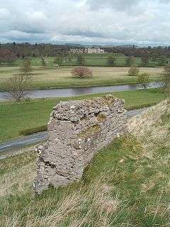 Roxburgh Castle, River Tweed and Floors Castle |
|
 Roxburgh |
|
| Population | 419 (2001) |
|---|---|
| OS grid reference | NT713337 |
| Civil parish | Roxburgh |
| Council area | Scottish Borders |
| Lieutenancy area | Roxburgh, Ettrick and Lauderdale |
| Country | Scotland |
| Sovereign state | United Kingdom |
| Post town | KELSO |
| Postcode district | TD5 |
| Dialling code | 01573 |
| Police | Scottish |
| Fire | Scottish |
| Ambulance | Scottish |
| EU Parliament | Scotland |
| UK Parliament | Berwickshire, Roxburgh and Selkirk |
| Scottish Parliament | Ettrick, Roxburgh and Berwickshire |
Coordinates: 55°35′47″N 2°27′22″W / 55.5965°N 2.4562°W
Roxburgh /ˈrɒksbərə/, also known as Rosbroch, is a civil parish and now-destroyed royal burgh, in its eponymous historic county of Roxburghshire in the Scottish Borders. It was an important trading burgh in High Medieval to early modern Scotland. In the Middle Ages it had at least as much importance as Edinburgh, Stirling, Perth, or Berwick-upon-Tweed, for a time acting as de facto capital (as royal residence of David I).
History
Its significance lay in its position in the centre of some of Lowland Scotland's most agriculturally fertile areas, and its position upon the River Tweed, which allowed river transport of goods via the main seaport of Berwick-upon-Tweed. Its position also acted as a barrier to English invasion.
The town stood on a defensible peninsula between the rivers Tweed and Teviot, with Roxburgh Castle guarding the narrow neck of the peninsula. Nothing remains of the town except some ruined segments of castle ramparts. Its site lies to the south of modern Kelso and Floors Castle, which lie on the other side of the Tweed. The Duke of Roxburghe owns the site.
English and Scots forces repeatedly captured and recaptured the town during the Scottish Wars of Independence, notably in 1314, in the run-up to Bannockburn. Its final recapture in 1460 saw the town and castle destroyed. After this time the town never regained its importance because the final English capture of Berwick-upon-Tweed in 1482 left Roxburgh with little reason to exist, henceforth lacking a port.
Roxburgh was superseded as the county town of the former county of Roxburghshire by Jedburgh.[1]
Etymology
Roxburgh probably comes from Old English *hrōcas burh, "rook's burgh".[2]
Roxburgh District
 Roxburgh District 1975–96
In more recent times (1975–1996), "Roxburgh" referred to a local government district in the Borders region of Scotland. Its borders broadly resembled those of the traditional county of Roxburghshire. In 1996 the district of Roxburgh became part of the Scottish Borders unitary area. (See also: Subdivisions of Scotland.)
Roxburgh village
Today the name Roxburgh belongs to a small village about 2 miles (3.2 km) south-southwest of the site of the historic Roxburgh.
See also
References
Notes
Sources
- Sadler, John (2005). Border Fury: England and Scotland at War, 1296–1568. Harlow, England: Pearson/Longman. ISBN 9780582772939. OCLC 55596227.
| Wikimedia Commons has media related to Roxburgh. |