List of the ultra-prominent summits of Alaska
The following sortable table comprises the 65 ultra-prominent summits of the U.S. State of Alaska. Each of these peaks has at least 1500 meters (4921 feet) of topographic prominence.
Topographic elevation is the vertical distance above the reference geoid, a mathematical model of the Earth's sea level as an equipotential gravitational surface. The topographic prominence of a summit is the elevation difference between that summit and the highest or key col to a higher summit. The topographic isolation of a summit is the minimum great-circle distance to a point of equal elevation.
This article defines a significant summit as a summit with at least 100 meters (328.1 feet) of topographic prominence, and a major summit as a summit with at least 500 meters (1640 feet) of topographic prominence. An ultra-prominent summit is a summit with at least 1500 meters (4921 feet) of topographic prominence. There are 126 ultra-prominent summits in the United States.
If an elevation or prominence is calculated as a range of values, the arithmetic mean is shown.
Ultra-prominent summits
Of the 126 ultra-prominent summits of the United States, the following 65 (or 52%) rise in Alaska. Four of these peaks lie on the international border with Yukon and two lie on the international border with British Columbia.
Gallery
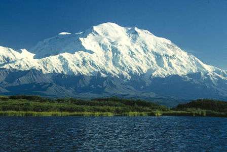
- 1Denali is the highest mountain peak of the State of Alaska, the United States of America, and all of North America.
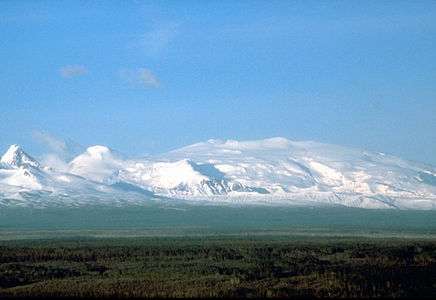
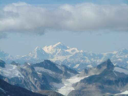 Mount Fairweather on the boundary between Alaska and British Columbia is the second most topographically prominent mountain peak of Alaska.
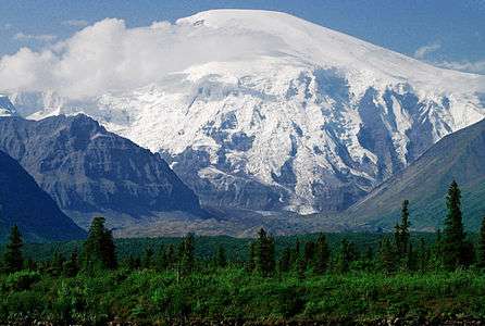
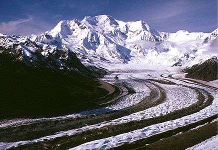 Mount Blackburn is the highest peak of the Wrangell Mountains.
 Mount Saint Elias on the boundary between Alaska and the Yukon is the second highest peak of both the United States and Canada.
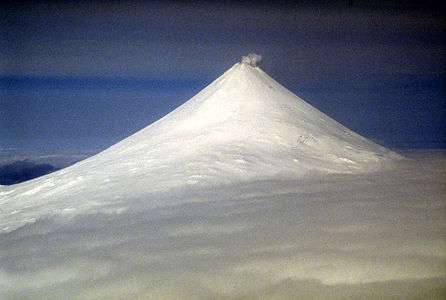
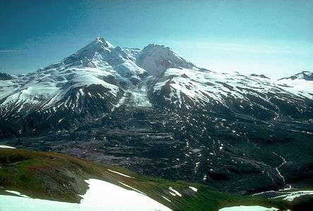
 1Mount Sanford is the second highest peak of the Wrangell Mountains.
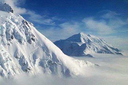
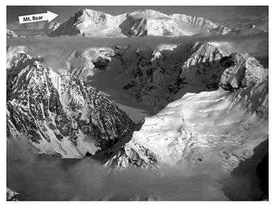 Mount Bear in the Saint Elias Mountains.
See also
- List of mountain peaks of North America
- List of mountain peaks of Greenland
- List of mountain peaks of Canada
- List of mountain peaks of the Rocky Mountains
- List of mountain peaks of the United States
- List of mountain peaks of Alaska
- List of the major 4000-meter summits of Alaska
- List of the ultra-prominent summits of Alaska
- List of mountain peaks of California
- List of mountain peaks of Colorado
- List of mountain peaks of Hawaiʻi
- List of mountain peaks of Alaska
- List of mountain peaks of México
- List of mountain peaks of Central America
- List of mountain peaks of the Caribbean
- Alaska
- Geography of Alaska
- Category:Mountains of Alaska
- Geography of Alaska
- Physical geography
References
- ↑ Denali is the highest point of the Alaska Range, the State of Alaska, the United States of America, and all of North America. Denali is the third most topographically prominent and third most topographically isolated summit on Earth after Mount Everest and Aconcagua..
- ↑ "Denali". Peakbagger.com. Retrieved October 23, 2015.
- ↑ The summit of Mount Fairweather is the highest point of the Fairweather Range and the Province of British Columbia.
- ↑ "Mount Fairweather". Geographical Names of Canada. Natural Resources Canada. Retrieved October 23, 2015.
- ↑ "Mount Fairweather". Peakbagger.com. Retrieved October 23, 2015.
- ↑ The summit of Mount Blackburn is the highest point of the Wrangell Mountains.
- ↑ "Mount Blackburn". Datasheet for NGS Station UV4136. United States National Geodetic Survey. Retrieved October 23, 2015.
- ↑ "Mount Blackburn". Peakbagger.com. Retrieved October 23, 2015.
- ↑ The summit of Mount Hayes is the highest point of the Hayes Range.
- ↑ "Mount Hayes". Peakbagger.com. Retrieved October 23, 2015.
- ↑ Mount Saint Elias is the second highest major summit of both Canada and the United States..
- ↑ "Mount Saint Elias". Geographical Names of Canada. Natural Resources Canada. Retrieved October 23, 2015.
- ↑ "Mount Saint Elias". Peakbagger.com. Retrieved October 23, 2015.
- ↑ The summit of Mount Marcus Baker is the highest point of the Chugach Mountains.
- ↑ "Mount Marcus Baker". Peakbagger.com. Retrieved October 23, 2015.
- ↑ The summit of Shishaldin Volcano is the highest point of Unimak Island and the Aleutian Islands.
- ↑ "Shishaldin Volcano". Peakbagger.com. Retrieved October 23, 2015.
- ↑ The summit of Redoubt Volcano is the highest point of the Chigmit Mountains.
- ↑ "Redoubt Volcano". Peakbagger.com. Retrieved October 23, 2015.
- ↑ The summit of Mount Torbert is the highest point of the Tordrillo Mountains.
- ↑ "Mount Torbert". Peakbagger.com. Retrieved October 23, 2015.
- ↑ The summit of Pavlof Volcano is the highest point of the Alaska Peninsula.
- ↑ "Pavlof Volcano". Peakbagger.com. Retrieved October 23, 2015.
- ↑ "Mount Veniaminof". Peakbagger.com. Retrieved October 23, 2015.
- ↑ "Mount Hubbard". Geographical Names of Canada. Natural Resources Canada. Retrieved October 23, 2015.
- ↑ "Mount Hubbard". Peakbagger.com. Retrieved October 23, 2015.
- ↑ The summit of Mount Isto is the highest point of the Brooks Range.
- ↑ "Mount Isto". Peakbagger.com. Retrieved October 23, 2015.
- ↑ "Iliamna Volcano". Peakbagger.com. Retrieved October 23, 2015.
- ↑ "Mount Cook". Geographical Names of Canada. Natural Resources Canada. Retrieved October 23, 2015.
- ↑ "Mount Cook". Peakbagger.com. Retrieved October 23, 2015.
- ↑ "Mount Sanford". Peakbagger.com. Retrieved October 23, 2015.
- ↑ "Mount Tom White". Peakbagger.com. Retrieved October 23, 2015.
- ↑ The summit of Mount Kimball is the highest point of the Delta Range.
- ↑ "Mount Kimball". Peakbagger.com. Retrieved October 23, 2015.
- ↑ "Mount Griggs". Peakbagger.com. Retrieved October 23, 2015.
- ↑ "Mount Foraker". Peakbagger.com. Retrieved October 23, 2015.
- ↑ "Mount Crillon". Peakbagger.com. Retrieved October 23, 2015.
- ↑ The summit of Mount Vsevidof is the highest point of Umnak Island and the westernmost 2000 meter (6561.7-foot) summit of greater North America.
- ↑ "Mount Vsevidof". Peakbagger.com. Retrieved October 23, 2015.
- ↑ The summit of Mount Hesperus is the highest point of the West Alaska Range.
- ↑ "Mount Hesperus". Peakbagger.com. Retrieved October 23, 2015.
- ↑ The summit of Mount Bona is the highest point of the northwest Saint Elias Mountains.
- ↑ "Mount Bona". Peakbagger.com. Retrieved October 23, 2015.
- ↑ "Mount Drum". Peakbagger.com. Retrieved October 23, 2015.
- ↑ "Mount Chiginagak". Peakbagger.com. Retrieved October 23, 2015.
- ↑ The summit of Mount Neacola is the highest point of the Neacola Mountains.
- ↑ "Mount Neacola". Peakbagger.com. Retrieved October 23, 2015.
- ↑ "Mount Douglas". Peakbagger.com. Retrieved October 23, 2015.
- ↑ "Kichatna Spire". Peakbagger.com. Retrieved October 23, 2015.
- ↑ "De Long Peak". Peakbagger.com. Retrieved October 23, 2015.
- ↑ "De Long Peak". Bivouac.com. Retrieved October 23, 2015.
- ↑ "Pogromni Volcano". Datasheet for NGS Station UV9965. United States National Geodetic Survey. Retrieved October 23, 2015.
- ↑ "Pogromni Volcano". Peakbagger.com. Retrieved October 23, 2015.
- ↑ "Peak 8010". Peakbagger.com. Retrieved October 23, 2015.
- ↑ The summit of Mount Igikpak is the highest point of the Schwatka Mountains.
- ↑ "Mount Igikpak". Peakbagger.com. Retrieved October 23, 2015.
- ↑ "Snow Tower". Peakbagger.com. Retrieved October 23, 2015.
- ↑ The summit of Truuli Peak is the highest point of the Kenai Mountains.
- ↑ "Truuli Peak". Peakbagger.com. Retrieved October 23, 2015.
- ↑ "Mount Natazhat". Peakbagger.com. Retrieved October 23, 2015.
- ↑ "Hanagita Peak". Datasheet for NGS Station UV3837. United States National Geodetic Survey. Retrieved October 23, 2015.
- ↑ "Hanagita Peak". Peakbagger.com. Retrieved October 23, 2015.
- ↑ The summit of Tanaga Volcano is the highest point of Tanaga Island and the Andreanof Islands.
- ↑ "Tanaga Volcano". Peakbagger.com. Retrieved October 23, 2015.
- ↑ The summit of Makushin Volcano is the highest point of Unalaska Island.
- ↑ "Makushin Volcano". Peakbagger.com. Retrieved October 23, 2015.
- ↑ The summit of Sovereign Mountain is the highest point of the Talkeetna Mountains.
- ↑ "Sovereign Mountain". Peakbagger.com. Retrieved October 23, 2015.
- ↑ "Isanotski Peaks". Peakbagger.com. Retrieved October 23, 2015.
- ↑ "Isthmus Peak". Peakbagger.com. Retrieved October 23, 2015.
- ↑ "Frosty Peak". Peakbagger.com. Retrieved October 23, 2015.
- ↑ The summit of Great Sitkin Volcano is the highest point of Great Sitkin Island.
- ↑ "Great Sitkin Volcano". Peakbagger.com. Retrieved October 23, 2015.
- ↑ The summit of Mount Cleveland is the highest point of Chuginadak Island.
- ↑ "Mount Cleveland". Datasheet for NGS Station UV9122. United States National Geodetic Survey. Retrieved October 23, 2015.
- ↑ "Mount Cleveland". Peakbagger.com. Retrieved October 23, 2015.
- ↑ "Mount Wrangell". Peakbagger.com. Retrieved October 23, 2015.
- ↑ The summit of Devils Paw is the highest point of the Juneau Icefield.
- ↑ "Devils Paw". Geographical Names of Canada. Natural Resources Canada. Retrieved October 23, 2015.
- ↑ "Devils Paw". Peakbagger.com. Retrieved October 23, 2015.
- ↑ "Mount Seattle". Peakbagger.com. Retrieved October 23, 2015.
- ↑ "Mount Russell". Peakbagger.com. Retrieved October 23, 2015.
- ↑ "Mount Foresta". Peakbagger.com. Retrieved October 23, 2015.
- ↑ The summit of Veniaminof Peak is the highest point of Baranof Island.
- ↑ "Veniaminof Peak". Peakbagger.com. Retrieved October 23, 2015.
- ↑ The summit of Bearhole Peak is the highest point of the Granite Range.
- ↑ "Bearhole Peak". Peakbagger.com. Retrieved October 23, 2015.
- ↑ "Bearhole Peak". Bivouac.com. Retrieved October 23, 2015.
- ↑ "Mount Steller". Peakbagger.com. Retrieved October 23, 2015.
- ↑ The summit of Mount Miller is the highest point of the Barkley Ridge.
- ↑ "Mount Miller". Peakbagger.com. Retrieved October 23, 2015.
- ↑ The summit of Carlisle Volcano is the highest point of Carlisle Island.
- ↑ "Carlisle Volcano". Datasheet for NGS Station TT5510. United States National Geodetic Survey. Retrieved October 23, 2015.
- ↑ "Carlisle Volcano". Peakbagger.com. Retrieved October 23, 2015.
- ↑ The summit of Bashful Peak is the highest point of the western Chugach Mountains.
- ↑ "Bashful Peak". Peakbagger.com. Retrieved October 23, 2015.
- ↑ "Tetlin Peak". Peakbagger.com. Retrieved October 23, 2015.
- ↑ "Mount Deborah". Peakbagger.com. Retrieved October 23, 2015.
- ↑ "Necous Peak". Peakbagger.com. Retrieved October 23, 2015.
- ↑ "Necous Peak". Bivouac.com. Retrieved October 23, 2015.
- ↑ The summit of Gareloi Volcano is the highest point of Gareloi Island.
- ↑ "Gareloi Volcano". Datasheet for NGS Station TT5136. United States National Geodetic Survey. Retrieved October 23, 2015.
- ↑ "Gareloi Volcano". Peakbagger.com. Retrieved October 23, 2015.
- ↑ "Peak 8488". Peakbagger.com. Retrieved October 23, 2015.
- ↑ "Mount Augusta". Geographical Names of Canada. Natural Resources Canada. Retrieved October 23, 2015.
- ↑ "Mount Augusta". Peakbagger.com. Retrieved October 23, 2015.
- ↑ "Peak 6915". Peakbagger.com. Retrieved October 23, 2015.
- ↑ "Mount Bear". Peakbagger.com. Retrieved October 23, 2015.
- ↑ The summit of Korovin Volcano is the highest point of Atka Island.
- ↑ "Korovin Volcano". Peakbagger.com. Retrieved October 23, 2015.
External links
- United States Geological Survey (USGS)
- United States National Geodetic Survey (NGS)
- United States National Park Service (NPS)
- Bivouac.com
- Peakbagger.com
- Peaklist.org
- Peakware.com
- Summitpost.org
Juneau (capital) | ||
| Topics |
|  |
| Society |
| |
| Regions | ||
| Largest cities | ||
| Boroughs | ||
| Census Areas | ||
Coordinates: 63°04′08″N 151°00′23″W / 63.0690°N 151.0063°W