Mount Humphreys
For the highest point in Arizona, see Humphreys Peak.
| Mount Humphreys | |
|---|---|
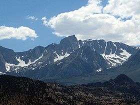 Mount Humphreys from the east | |
| Highest point | |
| Elevation | 13,992 ft (4,265 m) NAVD 88[1] |
| Prominence | 2563 ft (781 m) [1] |
| Isolation | 14.71 mi (23.67 km) [1] |
| Listing |
|
| Coordinates | 37°16′14″N 118°40′23″W / 37.270545708°N 118.672999478°WCoordinates: 37°16′14″N 118°40′23″W / 37.270545708°N 118.672999478°W [4] |
| Geography | |
| Location | Fresno / Inyo counties, California, U.S. |
| Parent range | Sierra Nevada |
| Topo map | USGS Mount Tom |
| Climbing | |
| First ascent | 1904 by Edward C. Hutchinson and James S. Hutchinson[5] |
| Easiest route | Climb, class 4[2] |
Mount Humphreys is a mountain peak in the Sierra Nevada on the Fresno-Inyo county line in the U.S. state of California. It is the 14th highest peak in California,[6] and the highest peak in the Bishop area. The mountain was named by the California Geological Survey of 1873 for Andrew A. Humphreys, the chief engineer of the United States Army at the time.[5]
See also
References
- 1 2 3 "Mount Humphreys, California". Peakbagger.com. Retrieved January 8, 2016.
- 1 2 "Sierra Peaks Section List" (PDF). Angeles Chapter, Sierra Club. Retrieved 2008-09-28.
- ↑ "Western States Climbers Qualifying Peak List". Retrieved 2016-03-24.
- ↑ "Mt Humphreys". NGS data sheet. U.S. National Geodetic Survey. Retrieved 2011-05-31.
- 1 2 Farquhar, Francis P. (1926). Place Names of the High Sierra. San Francisco: Sierra Club.
- ↑ "California 13,500-foot Peaks". Peakbagger.com. Retrieved 2014-01-17.
External links
- "Mount Humphreys". SummitPost.org.
- "Mount Humphreys". Geographic Names Information System. United States Geological Survey.
| Wikimedia Commons has media related to Mount Humphreys. |
This article is issued from Wikipedia - version of the 3/24/2016. The text is available under the Creative Commons Attribution/Share Alike but additional terms may apply for the media files.