Anchorage, Alaska
| Anchorage, Alaska | |||
|---|---|---|---|
| Unified Borough and City | |||
| Municipality of Anchorage | |||
|
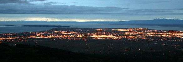
Anchorage skyline and Bootleggers Cove as photographed from Point Woronzof Park on an April evening. | |||
| |||
| Nickname(s): The City of Lights and Flowers | |||
| Motto: Big Wild Life | |||
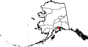 Location of Anchorage within Alaska | |||
| Coordinates: 61°13′N 149°54′W / 61.217°N 149.900°WCoordinates: 61°13′N 149°54′W / 61.217°N 149.900°W | |||
| Country |
| ||
| State |
| ||
| Borough | Anchorage | ||
| Settled | 1914 | ||
| Incorporated |
November 23, 1920 (city) January 1, 1964 (borough) September 15, 1975 (unified municipality) | ||
| Named for | The anchorage at the mouth of Ship Creek | ||
| Government | |||
| • Body | Anchorage Assembly[1] | ||
| • Mayor | Ethan Berkowitz | ||
| • Alaska Senate |
Senators
| ||
| • Alaska House |
Representatives
| ||
| Area | |||
| • Unified Borough and City | 1,968.6 sq mi (5,099 km2) | ||
| • Land | 1,704.7 sq mi (4,415 km2) | ||
| • Water | 263.9 sq mi (683 km2) | ||
| • Urban | 78.8 sq mi (204 km2) | ||
| Elevation | 102 ft (31 m) | ||
| Population (2010)[2] | |||
| • Unified Borough and City | 291,826 | ||
| • Estimate (2015)[3] | 298,695 | ||
| • Rank |
1st in Alaska 64th in the United States | ||
| • Density | 171.2/sq mi (66.1/km2) | ||
| • Urban | 251,243 (US: 149th)[4] | ||
| • Metro | 396,142 (US: 134th) | ||
| Demonym(s) | Anchoragite | ||
| Time zone | AKST (UTC-9) | ||
| • Summer (DST) | AKDT (UTC-8) | ||
| ZIP code | 99501–99524, 99529-99530, 99599 | ||
| Area code(s) | 907 | ||
| Geocode | 1398242 | ||
| FIPS code | 02-03000 | ||
| Website | City of Anchorage | ||


Anchorage (officially called the Municipality of Anchorage) (Dena'ina Athabascan: Dgheyaytnu) is a unified home rule municipality in the U.S. state of Alaska. With an estimated 298,695 residents in 2015,[5] it is Alaska's most populous city and contains more than 40 percent of the state's total population; among the 50 states, only New York has a higher percentage of residents who live in its most populous city. All together, the Anchorage metropolitan area, which combines Anchorage with the neighboring Matanuska-Susitna Borough, had a population of 396,142 in 2013.[6]
Anchorage is located in the south-central portion of Alaska at the terminus of the Cook Inlet on a peninsula formed by the Knik Arm to the north and the Turnagain Arm to the south.[7] The city limits span 1,961.1 square miles (5,079.2 km2) which encompass the urban core, a joint military base,[8] several outlying communities and almost all of Chugach State Park.[9]
Anchorage International Airport is a common refueling stop for many international flights and is home to a major FedEx Hub which the company calls a "critical part" of its global network of services.[10]
Anchorage has been named an All-America City four times, in 1956, 1965, 1984–85, and 2002, by the National Civic League.[11] It has also been named by Kiplinger as the most tax-friendly city in the United States.[12]
History
Russian presence in south central Alaska was well established in the 19th century. In 1867, U. S. Secretary of State William H. Seward brokered a deal to purchase Alaska from Imperial Russia for $7.2 million (about two cents an acre). His political rivals lampooned the deal as "Seward's folly", "Seward's icebox" and "Walrussia". By 1888, gold was discovered along Turnagain Arm.

Alaska became a United States territory in 1912. Anchorage, unlike every other large town in Alaska south of the Brooks Range, was neither a fishing nor mining camp. The area surrounding Anchorage lacks significant economic metal minerals. A number of Dena'ina settlements existed along Knik Arm for years. By 1911 the families of J. D. "Bud" Whitney and Jim St. Clair lived at the mouth of Ship Creek and were joined there by a young forest ranger.[13] Jack Brown, and his bride, Nellie, in 1912 to have lived in the Ship Creek valley in the 1910s prior to the large influx of settlers.
The city grew from its happenstance choice as the site, in 1914, under the direction of Frederick Mears, of a railroad-construction port for the Alaska Engineering Commission. The area near the mouth of Ship Creek, where the railroad headquarters was located, quickly became a tent city. A town site was mapped out on higher ground to the south of the tent city, greatly noted in the years since for its order and rigidity compared with other Alaska town sites.[14] In 1915, territorial governor John Franklin Alexander Strong encouraged residents to change the city's name to one that had "more significance and local associations".[15] In the summer of that year, residents held a vote to change the city's name; a plurality of residents favored changing the city's name to "Alaska City".[15] However, the territorial government ultimately declined to change the city's name.[15] Anchorage was incorporated on November 23, 1920.[14]
Construction of the Alaska Railroad continued until its completion in 1923. The city's economy in the 1920s and 1930s centered on the railroad. Col. Otto F. Ohlson, the Swedish-born general manager of the railroad for nearly two decades, became a symbol of residents' contempt due to the firm control he maintained over the railroad's affairs, which by extension became control over economic and other aspects of life in Alaska.

Between the 1930s and the 1950s, the city experienced massive growth as air transportation and the military became increasingly important. Aviation operations in Anchorage commenced along the firebreak south of town (today's Delaney Park Strip), which residents also used as a golf course. An increase in air traffic led to clearing of a site directly east of town site boundaries starting in 1929; this became Merrill Field, which served as Anchorage's primary airport during the 1930s and 1940s, until Anchorage International Airport replaced it in 1951. However, Merrill Field still sees a significant amount of general aviation traffic.
Elmendorf Air Force Base and Fort Richardson were constructed in the 1940s, and served as the city's primary economic engine until the 1968 Prudhoe Bay discovery shifted the thrust of the economy toward the oil industry. The 2005 Base Realignment and Closure process led to the combining of the two bases (along with Kulis Air National Guard Base) to form Joint Base Elmendorf-Richardson.

On March 27, 1964 the magnitude 9.2 Good Friday earthquake hit Anchorage, killing 115 people and causing $311 million ($2.38 billion current value)[16] in damage.[17][18] The earth-shaking event lasted nearly five minutes; most structures that failed remained intact for the first few minutes, then failed with repeated flexing.[17][18] It was the world's second-largest earthquake in recorded history.[17][18] Rebuilding dominated the remainder of the 1960s.
In 1968 ARCO discovered oil in Prudhoe Bay on the Alaska North Slope, and the resulting oil boom spurred further growth in Anchorage. In 1975, the City of Anchorage and the Greater Anchorage Area Borough (which includes Eagle River, Girdwood, Glen Alps, and several other communities) merged into the geographically larger Municipality of Anchorage[14] The city continued to grow in the 1980s, and capital projects and an aggressive beautification campaign took place.
Several attempts have been made to move Alaska's state capital from Juneau to Anchorage - or to a site closer to Anchorage. The motivation is straightforward: the "railbelt" between Anchorage and Fairbanks contains the majority of the state's population. Robert Atwood, owner of the Anchorage Times and a tireless booster for the city, championed the move. Alaskans rejected attempts to move the capital in 1960 and 1962, but in 1974, as Alaska's center of population moved away from Southeast Alaska and to the railbelt, voters approved the move. Communities such as Fairbanks and much of rural Alaska opposed moving the capital to Anchorage for fear of concentrating more power in the state's largest city. As a result, in 1976 voters approved a plan to build a new capital city near Willow, about 70 miles (110 km) north of Anchorage. Opponents to the move reacted by campaigning to defeat, in the 1978 elections, a nearly $1 billion bond issue to fund construction of the new capitol building and related facilities. Subsequent attempts to move the capital or the legislature to Wasilla, north of Anchorage, also failed.[19] Anchorage contains over twice as many state employees as Juneau, and is to a considerable extent the center of state and federal government activity in Alaska.
Geography
Anchorage is located in Southcentral Alaska. At 61 degrees north, it lies slightly farther north than Oslo, Stockholm, Helsinki and Saint Petersburg, but not as far north as Reykjavík or Murmansk. It is northeast of the Alaska Peninsula, Kodiak Island, and Cook Inlet, due north of the Kenai Peninsula, northwest of Prince William Sound and the Alaska Panhandle, and nearly due south of Denali.
The city is on a strip of coastal lowland and extends up the lower alpine slopes of the Chugach Mountains. Point Campbell, the westernmost point of Anchorage on the mainland, juts out into Cook Inlet near its northern end, at which point it splits into two arms. To the south is Turnagain Arm, a fjord that has some of the world's highest tides. Knik Arm, another tidal inlet, lies to the west and north. The Chugach Mountains on the east form a boundary to development, but not to the city limits, which encompass part of the wild alpine territory of Chugach State Park.
The city's sea coast consists mostly of treacherous mudflats. Newcomers and tourists are warned not to walk in this area because of extreme tidal changes and the very fine glacial silt. Unwary victims have walked onto the solid seeming silt revealed when the tide is out and have become stuck in the mud. The two recorded instances of this occurred in 1961 and 1988.[20]
According to the United States Census Bureau, the municipality has a total area of 1,961.1 square miles (5,079.2 km2); 1,697.2 square miles (4,395.8 km2) of which is land and 263.9 square miles (683.4 km2) of it is water. The total area is 13.46% water.
Boroughs and census areas adjacent to the Municipality of Anchorage are Matanuska-Susitna Borough to the north, Kenai Peninsula Borough to the south and Valdez-Cordova Census Area to the east. The Chugach National Forest, a national protected area, extends into the southern part of the municipality, near Girdwood and Portage.
Cityscape

Wildlife

A diverse wildlife population exists within urban Anchorage and the surrounding area. Approximately 250 black bears and 60 grizzly bears live in the area. Bears are regularly sighted within the city. Moose are also a common sight: in the Anchorage Bowl, there is a summer population of approximately 250 moose, increasing to as many as 1000 during the winter. They are a hazard to drivers, with over 100 moose killed by cars each year. Two people were stomped to death, in 1993 and 1995, in Anchorage.[21] Cross-country skiers and dog mushers using city trails have been charged by moose on numerous occasions; the Alaska Department of Fish and Game has to kill some individual aggressive moose in the city every year. Mountain goats can be commonly sighted along the Seward Highway between Anchorage and Girdwood, and Dall sheep are often viewed quite close to the road at Windy Point.[22] Approximately thirty northern timber wolves reside in the Anchorage area. In 2007 several dogs were killed by timber wolves while on walks with their owners.[23][24] There are also beaver dams in local creeks and lakes, and it is common to see foxes and kits in parking lots close to wooded areas in the spring. Along the Seward Highway headed toward Kenai, there are common sightings of beluga whales in the Turnagain Arm. Lynxes are occasionally sighted in Anchorage as well. Within the Municipality there are also a number of streams that host salmon runs. Fishing for salmon at Ship Creek next to downtown is popular in the summer.
Climate


Anchorage has a subarctic climate (the Köppen climate classification is Dsc) but with strong maritime influences that lead to a relatively moderate climate. Most of its precipitation falls in late summer. Average daytime summer temperatures range from approximately 55 to 78 °F (13 to 26 °C); average daytime winter temperatures are about 5 to 30 °F (−15.0 to −1.1 °C). Anchorage has a frost-free growing season that averages slightly over 101 days. According to local folklore, when a native plant called fireweed fully blooms then goes to seed, the first snowfall of winter is 6 weeks away.[25]
Average January low and high temperatures at Ted Stevens Anchorage International Airport (ANC) are 11 to 23 °F (−12 to −5 °C) with an average winter snowfall of 75.5 inches (192 cm).[26] The 2011–2012 winter had 134.5 in (341.6 cm), which made it the[27] snowiest winter on record, topping[27][28] the 1954–1955 winter with 132.8 in (337.3 cm). The coldest temperature ever recorded at the original weather station located at Merrill Field on the East end of 5th Avenue was −38 °F (−38.9 °C) on February 3, 1947.[nb 1]
Summers are typically mild (although cool compared to the contiguous US and even interior Alaska), and it can rain frequently, although not abundantly. Average July low and high temperatures are 52 to 66 °F (11 to 19 °C) and the highest reading ever recorded was 87 °F (30.6 °C) on June 18, 2013.[29] The average annual precipitation at the airport is 16.63 inches (422 mm).[30] Anchorage's latitude causes summer days to be very long and winter daylight hours to be very short. The city is often cloudy during the winter, which further decreases the amount of sunlight experienced by residents.[31]
Due to its proximity to active volcanoes, ash hazards are a significant, though infrequent, occurrence. The most recent notable volcanic activity centered on the multiple eruptions of Mount Redoubt during March–April 2009, resulting in a 25,000-foot (7,600 m) high ash cloud as well as ash accumulation throughout the Cook Inlet region. Previously, the most active recent event was an August 1992 eruption of Mount Spurr, which is located 78 miles (126 km) west of the city.[32] The eruption deposited about 3 mm (0.1 in) of volcanic ash on the city. The clean-up of ash resulted in excessive demands for water and caused major problems for the Anchorage Water and Wastewater Utility.
| Climate data for Anchorage (NWS Forecast Office),[33] 1981−2010 normals, extremes 1916−present | |||||||||||||
|---|---|---|---|---|---|---|---|---|---|---|---|---|---|
| Month | Jan | Feb | Mar | Apr | May | Jun | Jul | Aug | Sep | Oct | Nov | Dec | Year |
| Record high °F (°C) | 56 (13) |
57 (14) |
56 (13) |
72 (22) |
82 (28) |
85 (29) |
84 (29) |
85 (29) |
73 (23) |
64 (18) |
62 (17) |
53 (12) |
85 (29) |
| Average high °F (°C) | 22.7 (−5.2) |
27.1 (−2.7) |
35.0 (1.7) |
46.1 (7.8) |
56.9 (13.8) |
63.2 (17.3) |
65.4 (18.6) |
63.5 (17.5) |
55.6 (13.1) |
40.8 (4.9) |
27.3 (−2.6) |
23.8 (−4.6) |
44.0 (6.7) |
| Average low °F (°C) | 11.4 (−11.4) |
14.0 (−10) |
19.1 (−7.2) |
28.8 (−1.8) |
38.9 (3.8) |
46.8 (8.2) |
51.3 (10.7) |
49.3 (9.6) |
41.1 (5.1) |
28.9 (−1.7) |
16.9 (−8.4) |
13.3 (−10.4) |
30.0 (−1.1) |
| Record low °F (°C) | −35 (−37) |
−38 (−39) |
−24 (−31) |
−15 (−26) |
1 (−17) |
29 (−2) |
34 (1) |
31 (−1) |
19 (−7) |
−6 (−21) |
−21 (−29) |
−36 (−38) |
−38 (−39) |
| Average precipitation inches (mm) | 0.75 (19) |
0.73 (18.5) |
0.61 (15.5) |
0.47 (11.9) |
0.76 (19.3) |
0.96 (24.4) |
1.83 (46.5) |
3.25 (82.6) |
2.98 (75.7) |
2.04 (51.8) |
1.17 (29.7) |
1.12 (28.4) |
16.67 (423.4) |
| Average snowfall inches (cm) | 15.4 (39.1) |
10.0 (25.4) |
12.2 (31) |
5.4 (13.7) |
0.6 (1.5) |
0 (0) |
0 (0) |
0 (0) |
0.5 (1.3) |
5.1 (13) |
12.4 (31.5) |
20.5 (52.1) |
82.1 (208.5) |
| Average precipitation days (≥ 0.01 in) | 8.1 | 7.2 | 6.8 | 5.5 | 7.0 | 8.2 | 11.3 | 13.8 | 14.5 | 12.3 | 9.3 | 11.1 | 115.1 |
| Average snowy days (≥ 0.1 in) | 9.7 | 6.5 | 6.6 | 2.9 | 0.5 | 0 | 0 | 0 | 0.2 | 2.8 | 7.9 | 10.5 | 47.6 |
| Source #1: NOAA[30][34] | |||||||||||||
| Source #2: The Weather Channel [35] | |||||||||||||
| Climate data for Anchorage International Airport (1981−2010 normals) | |||||||||||||
|---|---|---|---|---|---|---|---|---|---|---|---|---|---|
| Month | Jan | Feb | Mar | Apr | May | Jun | Jul | Aug | Sep | Oct | Nov | Dec | Year |
| Average high °F (°C) | 23.1 (−4.9) |
26.6 (−3) |
33.9 (1.1) |
44.5 (6.9) |
56.0 (13.3) |
62.8 (17.1) |
65.4 (18.6) |
63.5 (17.5) |
55.1 (12.8) |
40.5 (4.7) |
27.8 (−2.3) |
24.8 (−4) |
43.7 (6.5) |
| Average low °F (°C) | 11.1 (−11.6) |
13.8 (−10.1) |
19.2 (−7.1) |
29.1 (−1.6) |
39.6 (4.2) |
47.7 (8.7) |
52.2 (11.2) |
50.0 (10) |
42.0 (5.6) |
29.1 (−1.6) |
16.6 (−8.6) |
13.2 (−10.4) |
30.3 (−0.9) |
| Average precipitation inches (mm) | 0.73 (18.5) |
0.72 (18.3) |
0.60 (15.2) |
0.47 (11.9) |
0.72 (18.3) |
0.97 (24.6) |
1.83 (46.5) |
3.25 (82.6) |
2.99 (75.9) |
2.03 (51.6) |
1.16 (29.5) |
1.11 (28.2) |
16.58 (421.1) |
| Average snowfall inches (cm) | 11.3 (28.7) |
10.9 (27.7) |
9.9 (25.1) |
4.0 (10.2) |
0.3 (0.8) |
0 (0) |
0 (0) |
0 (0) |
0.4 (1) |
7.9 (20.1) |
13.1 (33.3) |
16.7 (42.4) |
74.5 (189.2) |
| Average precipitation days (≥ 0.01 in) | 8.2 | 7.1 | 5.9 | 5.0 | 7.3 | 8.5 | 12.0 | 14.6 | 14.8 | 11.9 | 9.4 | 10.5 | 115.2 |
| Average snowy days (≥ 0.1 in) | 8.6 | 6.9 | 6.1 | 2.9 | 0.4 | 0 | 0 | 0 | 0.2 | 4.0 | 8.1 | 10.8 | 48.0 |
| Average relative humidity (%) | 73.4 | 71.4 | 66.1 | 64.3 | 61.6 | 65.6 | 71.4 | 75.1 | 75.9 | 74.5 | 77.1 | 77.1 | 71.1 |
| Mean monthly sunshine hours | 82.9 | 120.5 | 195.8 | 235.3 | 288.7 | 274.7 | 250.1 | 203.9 | 159.8 | 117.1 | 80.6 | 51.8 | 2,061.2 |
| Percent possible sunshine | 41 | 48 | 53 | 53 | 53 | 48 | 44 | 42 | 41 | 38 | 37 | 30 | 46 |
| Source: NOAA (relative humidity and sun 1961−1990)[36][37] | |||||||||||||
| Climate data for Campbell Airstrip (Anchorage Alaska) | |||||||||||||
|---|---|---|---|---|---|---|---|---|---|---|---|---|---|
| Month | Jan | Feb | Mar | Apr | May | Jun | Jul | Aug | Sep | Oct | Nov | Dec | Year |
| Average high °F (°C) | 20 (−7) |
26 (−3) |
35 (2) |
45 (7) |
58 (14) |
66 (19) |
68 (20) |
65 (18) |
55 (13) |
41 (5) |
26 (−3) |
22 (−6) |
43.9 (6.6) |
| Average low °F (°C) | 2 (−17) |
4 (−16) |
9 (−13) |
22 (−6) |
33 (1) |
41 (5) |
47 (8) |
44 (7) |
35 (2) |
22 (−6) |
7 (−14) |
5 (−15) |
22.6 (−5.3) |
| Average snowfall inches (cm) | 10 (25) |
16 (41) |
18 (46) |
9 (23) |
0.2 (0.5) |
0 (0) |
0 (0) |
0 (0) |
0 (0) |
9 (23) |
11 (28) |
18 (46) |
91.2 (232.5) |
| Source: NOAA[38] | |||||||||||||
Demographics
| Historical population | |||
|---|---|---|---|
| Census | Pop. | %± | |
| 1920 | 1,856 | — | |
| 1930 | 2,277 | 22.7% | |
| 1940 | 3,495 | 53.5% | |
| 1950 | 11,254 | 222.0% | |
| 1960 | 44,397 | 294.5% | |
| 1970 | 48,081 | 8.3% | |
| 1980 | 174,431 | 262.8% | |
| 1990 | 226,338 | 29.8% | |
| 2000 | 260,283 | 15.0% | |
| 2010 | 291,826 | 12.1% | |
| Est. 2015 | 298,695 | [39] | 2.4% |
| U.S. Decennial Census[40] 2015 Estimate[41] [42] | |||
According to the 2010 census, Anchorage had a population of 291,826 and its racial and ethnic composition was as follows:[43][44][45]
- White: 66.0% (62.6% Non-Hispanic White)
- Two or more races: 8.1%
- Asian: 8.1% (3.3% Filipino, 1.2% Korean, 1.1% Hmong)
- American Indian and Alaska Natives: 7.9% (1.4% Inupiat, 1.1% Yup'ik, 0.8% Aleutian)
- Black or African American: 5.6%
- Other race: 2.3%
- Native Hawaiians and Other Pacific Islanders: 2.0% (1.4% Samoan)
- Hispanic or Latino (of any race): 7.6% (4.4% Mexican, 1.2% Puerto Rican)
| Racial composition | 2010[46] | 1990[47] | 1970[47] | 1950[47] |
|---|---|---|---|---|
| White | 66.0% | 80.7% | 87.2% | 97.2% |
| —Non-Hispanic | 62.6% | 78.7% | n/a | n/a |
| Black or African American | 5.6% | 6.4% | 5.9% | n/a |
| Native American or Alaska Native | 7.9% | 6.4% | 1.8% | 1.2% |
| Hispanic or Latino (of any race) | 7.6% | 4.1% | 2.4%[48] | n/a |
| Asian | 8.1% | 4.8% | 1.0% | n/a |


According to the 2010 census, the largest national ancestry groups were as follows: 17.3% German, 10.8% Irish, 9.1% English, 6.9% Scandinavian (3.6% Norwegian, 2.2% Swedish, 0.6% Danish) and 5.6% French/French Canadian ancestry.[49][50]
According to the 2010 American Community Survey, approximately 82.3% of residents over the age of five spoke only English at home. Spanish was spoken by 3.8% of the population; speakers of other Indo-European languages made up 3.0% of the population; those who spoke Asian and Pacific Islander languages at home were 9.1%; and speakers of other languages made up 1.8%.[51]
In 2010, there were 291,826 people, 107,332 households and 70,544 families residing in the municipality. The population density was 171.2 per square mile (59.2/km2). There were 113,032 housing units at an average density of 59.1 per square miles (22.8/km2). There were 107,332 households out of which 33.2% had children under the age of 18 living with them, 48.4% were married couples living together, 11.7% had a female householder with no husband present, 5.6% had a male householder with no wife present, and 34.3% were non-families. 24.9% of all households were made up of individuals and 4.9% had someone living alone who was 65 years of age or older. The average household size was 2.64 and the average family size was 3.19. The age distribution was 26.0% under 18, 11.2% from 18 to 24, 29.0% from 25 to 44, 26.6% from 45 to 64, and 7.2% who were 65 or older. The median age was 32.9 years. 50.8% of the population was male and 49.2% were female.[52]
The median income for a household in the municipality was $73,004, and the median income for a family was $85,829. The per capita income for the municipality was $34,678. About 5.1% of families and 7.9% of the population were below the poverty line.[53][54] Of the city's population over the age of 25, 33.7% held a bachelor's degree or higher, and 92.1% had a high school diploma or equivalent.[49]
As of September 7, 2006, 94 languages were spoken by students in the Anchorage School District.[55]
Languages
In 2010, 83.7% (220,304) of Anchorage residents aged five and older spoke only English at home, while 4.47% (11,769) spoke Spanish, 2.53% (6,654) Tagalog, 1.56% (4,108) various Pacific Island languages, 1.38% (3,636) various Native American/Alaska Native languages, 1.14% (2,994) Korean, 0.63% (1,646) German, 0.57% (1,502) Hmong, 0.50% (1,307) Russian, and Japanese was spoken as a main language by 0.45% (1,185) of the population over the age of five. In total, 16.33% (43,010) of Anchorage's population aged five and older spoke a mother language other than English.[56]
Economy

Anchorage's largest economic sectors include transportation, military, municipal, state and federal government, tourism, corporate headquarters (including regional headquarters for multinational corporations) and resource extraction. Large portions of the local economy depend on Anchorage's geographical location and surrounding natural resources. Anchorage's economy traditionally has seen steady growth, though not quite as rapid as many places in the lower 48 states. With the notable exception of a real estate-related crash in the mid-to-late 1980s, which saw the failure of numerous financial institutions, it does not experience as much pain during economic downturns.
The Ted Stevens Anchorage International Airport (TSAIA) is the world's third busiest airport for cargo traffic, surpassed only by Memphis and Hong Kong. This traffic is strongly linked to Anchorage's location along "great circle" routes between Asia and the lower 48. In addition, the airport has an abundant supply of jet fuel from in-state refineries located in North Pole and Kenai. This jet fuel is transported to the Port of Anchorage, then by rail or pipeline to the airport.

The Port of Anchorage receives 95 percent of all goods destined for Alaska. Ships from Totem Ocean Trailer Express and Horizon Lines arrive twice weekly from the Port of Tacoma in Washington. Along with handling these activities, the port is a storage facility for jet fuel from Alaskan refineries, which is used at both TSAIA and Joint Base Elmendorf-Richardson (JBER).
The United States military used to have two large installations, Elmendorf Air Force Base and Fort Richardson, which originally stemmed from the branching off of the U.S. Air Force from the U.S. Army following World War II. In a cost cutting effort initiated by the 2005 BRAC proceedings, the bases were combined. JBER was created, which also incorporated Kulis Air National Guard Base near TSAIA. The combination of these three bases employ approximately 8,500 civilian and military personnel. These individuals along with their families comprise approximately ten percent of the local population. During the Cold War, Elmendorf became an important base due to its proximity to the Soviet Union, particularly as a command center for numerous forward air stations established throughout the western reaches of Alaska (most of which have since closed).

While Juneau is the official state capital of Alaska, there are actually more state employees who reside in the Anchorage area. Approximately 6,800 state employees work in Anchorage compared to about 3,800 in Juneau. The State of Alaska purchased the Bank of America Center (which it renamed the Robert B. Atwood Building) to house most of its offices, after several decades of leasing space in the McKay Building (now the McKinley Tower) and later the Frontier Building.
From Anchorage people can easily head south to popular fishing locations on the Kenai Peninsula or north to locations such as Denali National Park and Fairbanks.
The resource sector, mainly petroleum, is arguably Anchorage's most visible industry, with many high rises bearing the logos of large multinationals such as BP and ConocoPhillips. While field operations are centered on the Alaska North Slope and south of Anchorage around Cook Inlet, the majority of offices and administration are found in Anchorage. The headquarters building of ConocoPhillips Alaska, a subsidiary of ConocoPhillips, is located in downtown Anchorage.[57] It is also the tallest building in Alaska. Many companies who provide oilfield support services are likewise headquartered outside of Anchorage but maintain a substantial presence in the city, most notably Arctic Slope Regional Corporation and CH2M Hill.
Four small airlines, Alaska Central Express,[58] Era Aviation,[59] Hageland Aviation Services,[60] and PenAir, are headquartered in Anchorage.[61] Alaska Airlines, at one point headquartered in Anchorage, has major offices and facilities at TSAIA, including the offices of the Alaska Airlines Foundation.[62] Prior to their respective dissolutions, airlines MarkAir, Reeve Aleutian Airways and Wien Air Alaska were also headquartered in Anchorage.[63][64][65] The Reeve Building, at the corner of West Sixth Avenue and D Street, was spared the wrecking ball when the city block it sits on was cleared to make way for the 5th Avenue Mall, and was incorporated into the mall's structure. In 2013, Forbes named Anchorage among its list of Best Places for Business and Careers.[66]
Anchorage does not levy a sales tax. It does, however, charge a 12% bed tax on hotel stays and an 8% tax on car rentals.[67]
Arts

Located next to Town Square Park in downtown Anchorage, the Alaska Center for the Performing Arts is a three-part complex, hosting numerous performing arts events each year. The facility can accommodate more than 3,000 persons. In 2000, nearly 245,000 people visited 678 public performances. It is home to eight resident performing arts companies and has featured mega-musicals performed by visiting companies. The center also hosts the International Ice Carving Competition as part of the Fur Rendezvous festival in February.
The Anchorage Concert Association brings 20 to 30 events to the community each year, including Broadway shows like Disney's The Lion King, Les Misérables, Mamma Mia!, The Phantom of The Opera, West Side Story, and others. The Sitka Summer Music Festival presents an "Autumn Classics" festival of chamber music for two weeks each September on the campus of Alaska Pacific University. Orchestras include the Anchorage Symphony Orchestra and the Anchorage Youth Symphony.
Annually in January, the Anchorage Folk Festival takes place at the University of Alaska Anchorage, featuring concerts, dances, and workshops with featured guest artists and over 130 performances by volunteer singers, dancers, musicians, and storytellers.
- Alaska Native Heritage Center[68]
- Alaska Museum of Natural History[69]
- Alaska Aviation Heritage Museum
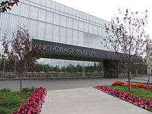
- Anchorage Museum at Rasmuson Center[70]
- Imaginarium: Science Discovery Center[71]
- Oscar Anderson House Museum[72]
- Wells Fargo Alaska Heritage Library & Museum[73]
The city of Anchorage currently provides three municipal facilities large enough to hold major events such as concerts, trade shows and conventions. Downtown facilities include the Alaska Center for the Performing Arts, William A. Egan Civic & Convention Center and the recently completed Dena’ina Civic and Convention Center, which will eventually be connected via skybridge to form the Anchorage Civic & Convention District. The Sullivan Arena hosts sporting events as well concerts and annual trade shows.
Sports


National attention is focused on Anchorage on the first Saturday of each March, when the Iditarod Trail Sled Dog Race kicks off with its ceremonial start downtown on Fourth Avenue. Anchorage is also home to the Fur Rendezvous Open World Championship Sled Dog Races, a three-day dog sled sprint event consisting of 3 timed races of 25.5 miles (41.0 km) each. Held each February, the event is part of the annual Fur Rendezvous, a winter sports carnival.
Anchorage is the home of three teams in the Alaska Baseball League. The Anchorage Bucs, Anchorage Glacier Pilots which both play at Mulcahy Stadium, and the Chugiak-Eagle River Chinooks based at Lee Jordan Field in Chugiak.[74]
Anchorage currently has one professional sports team: the Alaska Aces of hockey's ECHL.
The University of Alaska Anchorage Seawolves are a member of the National Collegiate Athletic Association. UAA has Division I teams in gymnastics and hockey, as well as several other Division II teams. UAA sponsors the annual Great Alaska Shootout, an annual NCAA Division I basketball tournament featuring colleges and universities from across the United States along with the UAA team.
Anchorage is the finish line for the Sadler's Ultra Challenge wheelchair race, and holds the ceremonial start of the Iditarod Trail Sled Dog Race.
There are four rugby clubs, including the Bird Creek Barbarians RFC, Anchorage Thunderbirds,[75] Mat Valley Maulers RFC, and Spenard Green Dragons.[76] The season runs from April through September.
The Anchorage Northern Knights gained national attention when they joined the eight-team Eastern Basketball Association in 1977, a league whose nearest competitor was 5,000 miles (8,000 km) from Anchorage. The Knights captured the 1979–80 league championship, and featured several players who would play in the NBA, most notably Brad Davis, a future player and broadcaster for the Dallas Mavericks. They competed in the renamed Continental Basketball Association for five seasons until the economic recession ended their run in 1982.
The city was the U.S. candidate for hosting the 1992 and 1994 Winter Olympics, but lost to Albertville, France and Lillehammer, Norway respectively. Anchorage is a premier cross-country skiing city, in terms of density of groomed trails within the urban core. There are 105 miles (169 km) of maintained ski trails in the city, some of which reach downtown. The same trail system also provides access to Chugach State Park, a 495,000-acre (200,000 ha) high alpine park.[77] The Tour of Anchorage is an annual 50-kilometer ski race within the city.[78] and is the Host for the 2009 and 2010 US Senior National Cross Country Ski Championship.[79]
Anchorage is also home to Alaska's first WFTDA flat track women's roller derby league, the Rage City Rollergirls.[80]
The Anchorage Football Stadium is also a noteworthy sports venue.
The 1989 World Junior Ice Hockey Championships was played in town.
Parks and recreation


Parks, gardens, and wildlife refuges
- Alaska Native Heritage Center[81]
- The Alaska Botanical Garden contains over 900 species of hardy perennials and 150 native plant species[82]
- Alaska Zoo[83]
- Alaska Wildlife Conservation Center[84]
- Anchorage Coastal Wildlife Refuge
- Delaney Park Strip
- Kincaid Park
- Point Woronzof Park
- Flattop Mountain Recreation Area
- Westchester Lagoon/Margaret Eagan Sullivan Park
- Numerous other city parks throughout the borough
Recreational facilities
- Arctic Valley Ski Area[85]
- Alyeska Resort[86]
- Hilltop Ski Area[87]
- Kincaid Park[88]
- Tony Knowles Coastal Trail
Points of interest
- Moose's Tooth Pub and Pizzeria, a pub and pizzeria currently ranked 3rd best in the United States
Government and politics


Anchorage is governed by an elected mayor and 11-member assembly, with the assistance of a city manager. These positions are non-partisan (as is the case with all municipal elected offices in Alaska), and thus no candidates officially run under any party banner. All eleven members are elected from districts known as sections. Five of the sections elect two members from designated seats, while the remaining section elects one member. Prior to the 1980 United States Census, the single-member section was the one centered around the northern Anchorage communities of Chugiak and Eagle River. Since that census, the area encompassing Downtown Anchorage and surrounding neighborhoods has served as the city's single-member section. The mayor (along with members of the school board) is elected in a citywide vote. In practice, however, the party affiliation and political ideology of major candidates are usually well known, and is highlighted by local media for the purposes of framing debate. The city's current mayor is Ethan Berkowitz, a registered Democrat. Along with 7 sister cities in the SCI program, Anchorage has a cultural exchange program with the former Yugoslavia nation of Montenegro.
Anchorage generally leans toward Republican candidates in both state and presidential elections. However, since the establishment of the municipality in 1975, there have been two Democratic mayors (Tony Knowles and Mark Begich) who have been elected to two consecutive terms. Downtown, Girdwood, and much of both the west and east parts of town trend Democratic. However, areas closest to the military bases – including Eagle River – and south Anchorage are the most Republican areas of the Municipality. Midtown is relatively moderate by comparison.
Anchorage-Eagle River sends 16 representatives (currently 9 Republicans and 7 Democrats) to the 40-member Alaska House of Representatives and eight senators (currently 5 Republicans and 3 Democrats) to the 20-member Senate. When seats from the neighboring Mat-Su Borough are added, more than half of the Alaska state legislature comes from the Anchorage metropolitan area. This is often used as an argument in favor of moving the state capital from Juneau to a location in the Anchorage area.
Voting trends show that Downtown Anchorage votes Democratic in large margins, while Spenard, Turnagain/Inlet View, and University/Airport Heights are relatively moderate and swing in elections. The remaining Anchorage area votes Republican.[89]
Public safety

With a reported strength of 383 sworn officers, the Anchorage Police Department is the largest police department in the state, serving an area of 159 square miles with a population of 300,950.[90] The Fire & EMS Operations Division of the Anchorage Fire Department (AFD) includes thirteen fire stations with over 300 personnel covering three rotating 24-hour shifts. Additionally, there are volunteer fire departments in Girdwood and Chugiak and fire departments on Elmendorf Air Force Base and Fort Richardson, as well as the Airport Police and Fire Department.[91]
| Violent crimes[nb 2] per 100,000 pop. |
Property crimes[nb 3] per 100,000 pop. | |
|---|---|---|
| Anchorage[92] | 837.7 | 3,518.0 |
| Alaska[93] | 638.8 | 2,852.5 |
| U.S. cities, pop. 100,000–249,999[94] |
519.6 | 3,846.8 |
| U.S. cities, pop. 250,000–499,999[94] |
757.7 | 4,216.6 |
| U.S. total[93] | 403.6 | 2,941.9 |
Source: FBI Uniform Crime Reports | ||
In 2010, Anchorage reported 837.7 violent crimes per 100,000 population and 3,518.0 property crimes per 100,000 population (see table). Anchorage's crime rate, both for violent and property crimes, is higher than for Alaska as a whole or for the U.S. as a whole. When compared with U.S. cities of similar size, Anchorage has a slightly higher rate of violent crime and a slightly lower rate of property crime. Anchorage, and Alaska in general, have very high rates of sexual assault in comparison with the rest of the country, with Anchorage's annual rate of forcible rapes over three times as high as for the U.S. as a whole. In 2010, the rate of rape for Anchorage was 90.9 per 100,000 population,[92] while the U.S. rate was 27.5 per 100,000 population.[93] Alaska Natives are victimized at a much higher rate than their representation in the population.[95]
The Anchorage Community Survey, a public survey conducted in 2004–2005 by the Justice Center at University of Alaska Anchorage, found that overall, Anchorage residents are fairly satisfied with the performance of the Anchorage Police Department.[96] Most survey respondents perceived the justice system to be "somewhat effective" or "very effective" at apprehending and prosecuting criminal suspects, bringing about just outcomes, and reducing crime.[97]
Education

Public education in Anchorage, Eagle River, Chugiak, Fort Richardson and Elmendorf Air Force Base is managed by the Anchorage School District, the 87th largest district in the United States, with nearly 50,000 students attending 98 schools.[98] There are also a number of choices in private education, including both religious and non-denominational schools.
Anchorage has four higher-education facilities that offer bachelor's or master's degrees: the University of Alaska Anchorage,[99] Alaska Pacific University, Charter College,[100] and the Anchorage campus of Texas-based Wayland Baptist University. The University of Alaska Fairbanks also has a small Center for Distance Education downtown. Other continuing education facilities in Anchorage include the Grainger Leadership Institute, Nine Star Enterprises, CLE International, Nana Worksafe, and PackBear DBA Barr & Co.
Ninety percent of Anchorage's adults have high-school diplomas, 65 percent have attended one to three years of college, and 17 percent hold advanced degrees.
Anchorage has the most ethnically diverse schools in the United States, including the three most diverse high schools, the three most diverse middle schools, and the 19 most diverse elementary schools. Even the least diverse schools in Anchorage rank in the top 1% nationally.[101]
Media

Anchorage's leading newspaper is the Alaska Dispatch News,[102] a citywide daily newspaper. Other newspapers include the Alaska Star,[103] serving primarily Chugiak and Eagle River, the Anchorage Press,[104] a free weekly covering mainly cultural topics, and The Northern Light,[105] the student newspaper of the University of Alaska Anchorage. Anchorage's major network television affiliates are KTUU 2 (NBC), KTBY 4 (Fox), KYES 5 (MyNetworkTV), KAKM 7 (PBS), KTVA 11 (CBS), KYUR 13 (ABC/CW), and KDMD 33 (Ion/Telemundo). Anchorage is one hour behind the Pacific Time Zone, and receives the same network feed as the West Coast. Weekday primetime runs from 7 to 10 pm. Effectively, programs are viewed at the same local hour as those in the Central Time Zone. The city's only cable television provider is General Communication, Inc. (GCI). However, Dish Network and DirecTV offer satellite television service in Anchorage and the surrounding area.
There are many radio stations in Anchorage; see List of radio stations in Alaska for more information.
Health and utilities

Providence Alaska Medical Center on Providence Drive in Anchorage is the largest hospital in Alaska and is part of Providence Health & Services in Alaska, Washington, Oregon and California. It features the state's most comprehensive range of services. Providence Health System has a history of serving Alaska, beginning when the Sisters of Providence of Montreal first brought health care to Nome in 1902. As the territory grew during the following decades, so did efforts to provide care. Hospitals were opened in Fairbanks in 1910 and Anchorage in 1937.
Alaska Regional Hospital on DeBarr Road opened in 1958 as Anchorage Presbyterian Hospital, located downtown at 825 L Street. This predecessor to Alaska Regional was a joint venture between local physicians and the Presbyterian Church. In 1976 the hospital moved to its present location on DeBarr Road, and is now a 254-bed licensed and accredited facility. Alaska Regional has expanded services and in 1994, Alaska Regional joined with HCA, one of the nation's largest healthcare providers.
Alaska Native Medical Center located on Tudor Road, provides medical care and therapeutic health care to Alaska natives – 229 tribes – at the Anchorage site and at 15 satellite facilities throughout the state. ANMC specialists also travel to clinics in the bush to provide care. The 150-bed hospital is also a teaching center for the University of Washington's regional medical education program. ANMC houses an office of the Centers for Disease Control and Prevention. The Alaska Native Tribal Health Consortium and Southcentral Foundation jointly own and manage ANMC.
The Municipal Light & Power (ML&P) and Chugach Electric Association provide electricity to the city. A municipally owned utility since 1932, ML&P supplies electric power to more than 30,000 residential and commercial customers in the Anchorage area. Chugach Electric Association is a not-for-profit, member-owned cooperative that was formed in 1948.
Most homes have natural gas-fueled heat. ENSTAR Natural Gas Company is the sole provider for Anchorage, servicing some 90-percent of the city's population.
The Municipality of Anchorage owns and operates the Anchorage Water and Wastewater Utility, serving some 55,000 customer accounts with water from the glacier-influenced Eklutna Lake. Anchorage Municipal Solid Waste Services and Anchorage Refuse conduct trash removal in the city depending on location.
Transportation
Roads

There is one numbered state highway in Anchorage, Alaska Route 1. Southbound from the Fairview neighborhood, it is known as the Seward Highway, connecting Anchorage to the Kenai Peninsula. Eastbound from the Mountain View neighborhood and then northerly through and beyond Joint Base Elmendorf-Richardson and Eagle River, it is known as the Glenn Highway. Within the city center, Alaska Route 1 is known as Gambell and Ingra Streets, and East Fifth and East Sixth Avenues. With the exception of the Portage Glacier Highway and Anton Anderson Memorial Tunnel, which connects the Alaska Marine Highway and Whittier to the Seward Highway, there is no other road access to Anchorage. A portion of the Seward Highway, approximately 10 miles (16 km) long and stretching from 36th Avenue in midtown Anchorage to 154th Avenue near Potter Marsh, is built to freeway standards.
The Glenn Highway carries commuter traffic to and from Eagle River, Chugiak, and the Matanuska-Susitna Valley cities of Palmer and Wasilla. It also leads further to connect to the Richardson Highway and Tok Cut-Off, with further connections to the contiguous North American highway system via the Alaska Highway. Beginning as a six-lane expressway near Merrill Field and becoming a freeway near the Northway Mall (as well as being formally designated the Glenn Highway as opposed to East Fifth Avenue at this point), the highway reduces to four lanes where it crosses the Eagle River. After leaving municipal limits, the freeway crosses the Knik and Matanuska Rivers as well as the Palmer Hay Flats State Game Refuge before coming to an interchange with the George Parks Highway (Alaska Route 3). The interchange, completed in 2004, continues the freeway along the Parks Highway. The freeway ends in the eastern reaches of Wasilla city limits; the Parks Highway continues to Fairbanks. The Glenn Highway becomes a two-lane highway shortly beyond this interchange. Part of Alaska Route 1, as well as parts of other Alaska state highways, are eligible for federal funding under the Interstate Highway System.
Another major road in Anchorage is the Walter J. Hickel Expressway, known locally to most residents as Minnesota Drive (as well as O'Malley Road, after the expressway curves eastward). Starting at the southern end of the I/L Street couplet at 15th Avenue, the couplet merges and becomes Minnesota Drive, which passes underneath Hillcrest Drive and heads south through the Spenard neighborhood. (The overpass has a southbound exit ramp only, and a northbound on-ramp that extends from the intersection of Spenard Road and Hillcrest Drive. This onramp used to be the original alignment of Spenard Road as it proceeded into the downtown area; now it is just a one lane, one-way road, with one intersection with 19th Avenue, before merging with northbound Minnesota Drive.) South of Tudor Road, Minnesota Drive becomes a freeway, with interchanges with International Airport Road, Raspberry Road, Strawberry Road (southbound exit only), Dimond Boulevard, and 100th Avenue. After the 100th Avenue interchange, Minnesota Drive curves east and becomes O'Malley Road. After the curve, O'Malley Road has one interchange (C Street) before it comes to an at-grade intersection with Old Seward Highway, where the Expressway designation ends and O'Malley Road continues as a local road. Immediately beyond that, O'Malley Road passes through a diamond interchange, providing access to Seward Highway/Alaska Route 1. If one were to continue on O'Malley Road beyond Seward Highway, they would eventually pass by the Alaska Zoo.
Highway to Highway
On and off since the 1960s, the Alaska Department of Transportation & Public Facilities, in coordination with the Federal Highway Administration and the Municipality of Anchorage (or the lineal predecessors of those entities), have been exploring the concept of a roadway connecting the endpoints of the Seward and Glenn highways. The project is called "Highway to Highway", and the most recent concept for this project is that of a "trenched" freeway through the heart of Anchorage.
Highway to Highway was included in the 2005 Long Range Transportation Plan, and would cost at least $575 million (2005 dollars) – by far the largest urban infrastructure project in Alaska's history.
Public transit
Anchorage has a bus system called People Mover,[106] with a central hub in downtown Anchorage and satellite hubs at Dimond Center and Muldoon Mall. The People Mover provides carpool organization services. The public paratransit service known as AnchorRides [107] provides point-to-point accessible transportation services to seniors and those who experience disabilities.
Rail

The Alaska Railroad offers year-round freight service along the length of its rail system between Seward (the southern terminus of the system), Fairbanks (the northern terminus of the system), and Whittier (a deep water, ice-free port). Daily passenger service is available during summer (May 15 – September 15), but is reduced to one round-trip per week between Anchorage and Fairbanks during the winter.[108][109][110] Passenger terminals exist at Talkeetna, Denali National Park, Fairbanks, and several other locations. These communities are also served by bus line from Anchorage. The Ship Creek Shuttle connects downtown with the Ship Creek area, including stops at the Alaska Railroad depot.
Anchorage also is currently conducting a feasibility study on a commuter rail and light rail system.[111][112] For the commuter rail system, Anchorage would use existing Alaska Railroad tracks to provide service to Whittier, Palmer, Seward, Wasilla, and Eagle River.
Air transport


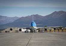
The Ted Stevens Anchorage International Airport, 6 miles (9.7 km) south of downtown Anchorage, is the airline hub for the state, served by many national and international airlines, including Seattle-based Alaska Airlines as well as many intrastate airlines and charter air services. The airport is the primary international air freight gateway in the nation. By weight, five percent of the value of all United States international air cargo moved through Anchorage in 2008.[113] Next to Ted Stevens Anchorage International Airport is Lake Hood Seaplane Base, the largest Seaplane Base in the world. Merrill Field, a general aviation airport on the edge of downtown, was the 87th-busiest airport in the nation in 2010.[114] There are also ten smaller private (mostly Department Of Transportation) general aviation airports within the city limits.[115]
Sister Cities of Anchorage
See Box at Far Right for Anchorage's Sister Cities. More information at Municipality of Anchorage's Sister City Commission website.
| Sister cities[116] |
|---|
| |
| |
| |
| |
| |
| |
See also
- Anchorage Fire Department
- Anchorage (song) by singer Michelle Shocked.
- List of aerospace museums
- List of tallest buildings in Anchorage
- National Register of Historic Places listings in Anchorage, Alaska
Notes
- ↑ In an average winter, the first snow happens in mid-October and begins to thaw in mid-March, but snow can sometimes be present until the end of April. The high temperature would usually drop below freezing at the beginning of November. The average first frost happens during the first half of September and the average last frost happens during the second half of May. In March 2002, a record snow storm, 26.7 inches, hit Anchorage."Temperature Records for Anchorage Alaska" (PDF). National Oceanic and Atmospheric Administration. Retrieved April 1, 2012.
- ↑ Includes of murder and nonnegligent manslaughter, forcible rape, robbery, and aggravated assault.
- ↑ Includes burglary, larceny-theft, motor vehicle theft, and arson.
References
- ↑ "Anchorage Assembly". Municipality of Anchorage. Retrieved 2014-02-09.
- ↑ "American FactFinder". United States Census Bureau. Retrieved 2014-02-09.
- ↑ "QuickFacts". United States Census Bureau. Retrieved 2016-03-09.
- ↑ "2010 Census Urban Area List". United States Census Bureau. Retrieved 2014-02-09.
- ↑ "Population Estimates". United States Census Bureau. Retrieved 2016-08-29.
- ↑ "Metropolitan and Micropolitan Statistical Areas". U.S. Census Bureau. September 11, 2014. Retrieved September 11, 2014.
- ↑ "Alaska Geography". Archived from the original on 18 October 2014.
- ↑ William Fulton, Jessica Daniels, Benjamin de la Peña (2008). "CASE STUDIES IN SMART GROWTH IMPLEMENTATION - Anchorage, Alaska" (PDF). SMART GROWTH LEADERSHIP INSTITUTE.
- ↑ State of Alaska. "Chugach State Park, Alaska State Parks". alaska.gov. Retrieved October 18, 2015.
- ↑ "Latest Global News" (PDF). About FedEx. Retrieved October 18, 2015.
- ↑ "National Civil League All-America winners by state". National Civic League. Retrieved July 2, 2008.
- ↑ "Top 10 Tax-Friendly Cities". Kiplinger. Retrieved February 15, 2016.
- ↑ A Gathering of Saints in Alaska: an informal chronicle of the Church of Jesus Christ of Latter-day Saints in the state of Alaska. Alaska: Mormon Church. 1983. p. 306.
- 1 2 3 "Community Database Online, Anchorage". Alaska Division of Community and Regional Affairs. Retrieved July 4, 2011.
- 1 2 3 Jones, Preston (2010). City for Empire: An Anchorage History, 1914-1941. University of Alaska Press. pp. 169–70. ISBN 1602230854.
- ↑ Federal Reserve Bank of Minneapolis Community Development Project. "Consumer Price Index (estimate) 1800–". Federal Reserve Bank of Minneapolis. Retrieved October 21, 2016.
- 1 2 3 "The Great Alaska Earthquake of 1964". Geophysical Institute, UAF. Alaska Earthquake Information Center. Archived from the original on July 6, 2011. Retrieved July 4, 2011.
- 1 2 3 "Historic Earthquakes, Prince William Sound, Alaska". USGS. Archived from the original on June 23, 2011. Retrieved July 4, 2011.
- ↑ "Alaska History and Cultural Studies - Governing Alaska - The Capital of Alaska". akhistorycourse.org. Retrieved October 18, 2015.
- ↑ Danger Stalks the Land: Alaskan Tales of Death and Survival By Larry Kaniut – St. Martins Press 1999 – Page 2-6 and 287–291
- ↑ "Moose Stomps Man to Death on College Campus". Associated Press.
- ↑ "Alaska Highway Drives from Anchorage". Alaska.org. Archived from the original on September 20, 2010. Retrieved August 31, 2010.
- ↑ "Alaska Dept. of Fish and Game, Living with Wildlife in Anchorage: a Cooperative Planning Effort". State of Alaska. April 2000. Archived from the original on January 5, 2008. Retrieved February 8, 2008.
- ↑ "North Side wolf pack attacks, kills dogs". Anchorage Daily News. December 11, 2007. Retrieved February 8, 2008.
- ↑ "Fireweed: Countdown to Winter". Human Flower Project. Retrieved 29 October 2014.
- ↑ [National Weather Service http://w2.weather.gov/climate/xmacis.php?wfo=pafc]
- 1 2 "Record-breaking Snowfall in Anchorage". ktuu.com. 2012-04-07. Retrieved 2012-06-09.
- ↑ "Snowfall Records for Anchorage Alaska" (PDF). National Oceanic and Atmospheric Administration. Retrieved April 1, 2012.
- ↑ Alaska Bakes with Alltime Heat Records
Weather Underground. June 21, 2013. Retrieved January 20, 2016 - 1 2 "NowData - NOAA Online Weather Data". National Oceanic and Atmospheric Administration. Retrieved 2012-03-31.
- ↑ "For November, December, and January, average monthly percent possible sunshine (the hours of direct sunlight experienced, divided by the possible hours of sunlight for the location) is below 35%". Climate.umn.edu. Archived from the original on October 19, 2012. Retrieved 2012-10-15."For an explanation of the concept "percent possible sunlight". Data Through 2005 Average Percent Possible Sunshine at National Climatic Data Center. Retrieved November 20, 2006.
- ↑ "Mt. Spurr's 1992 Eruptions". Alaska Volcano Observatory. Archived from the original on December 9, 2008. Retrieved November 26, 2008.
- ↑ The office is located at 61°09′22″N 149°59′02″W / 61.1562°N 149.9840°W, just south of the airport grounds. Anchorage weather data were recorded at Merrill Field from February 1916 to January 1953 and at Ted Stevens Anchorage International Airport from February 1953 to January 1998; the data have been recorded at the NWS office since February 1998.
- ↑ "Station Name: AK ANCHORAGE FRCST OFC". National Oceanic and Atmospheric Administration. Retrieved 2014-03-13.
- ↑ "Monthly Averages for Anchorage, AK". The Weather Channel. Retrieved 2009-10-07.
- ↑ "Station Name: AK ANCHORAGE INTL AP". National Oceanic and Atmospheric Administration. Retrieved 2014-03-11.
- ↑ "WMO climate normals for Anchorage/INTL, AK 1961−1990". National Oceanic and Atmospheric Administration. Retrieved 17 February 2015.
- ↑ "NOAA Weather Data, 1981–2010".
- ↑ "Annual Estimates of the Resident Population for Incorporated Places: April 1, 2010 to July 1, 2015". Retrieved July 2, 2016.
- ↑ "U.S. Decennial Census". Census.gov. Archived from the original on May 11, 2015. Retrieved June 30, 2013.
- ↑ "Population Estimates". United States Census Bureau. Retrieved August 4, 2016.
- ↑ Moffatt, Riley. Population History of Western U.S. Cities & Towns, 1850–1990. Lanham: Scarecrow, 1996, 1.
- ↑ "U.S. Census Bureau". FactFinder.census.gov. Archived from the original on March 5, 2014. Retrieved 2012-10-15.
- ↑ "U.S. Census Bureau". FactFinder.census.gov. Retrieved 2012-10-15.
- ↑ "U.S. Census Bureau". FactFinder.census.gov. Retrieved 2012-10-15.
- ↑ "Anchorage Municipality, Alaska". State & County QuickFacts. U.S. Census Bureau.
- 1 2 3 "Race and Hispanic Origin for Selected Cities and Other Places: Earliest Census to 1990". U.S. Census Bureau. Retrieved April 20, 2012.
- ↑ From 15% sample
- 1 2 "U.S. Census Bureau". FactFinder.census.gov. Retrieved 2012-10-15.
- ↑ "U.S. Census Bureau". FactFinder.census.gov. Retrieved 2012-10-15.
- ↑ "U.S. Census Bureau". FactFinder.census.gov. Retrieved 2012-10-15.
- ↑ "U.S. Census Bureau". FactFinder.census.gov. Retrieved 2012-10-15.
- ↑ "Anchorage (municipality) QuickFacts from the US Census Bureau". Quickfacts.census.gov. Retrieved 2012-10-13.
- ↑ "U.S. Census Bureau". FactFinder.census.gov. Retrieved 2012-10-15.
- ↑ "About the Anchorage School District - Languages our students speak". ASD Online - Anchorage School District. Retrieved April 1, 2009.
- ↑ "Anchorage Municipality County, Alaska". Modern Language Association. Archived from the original on August 15, 2013. Retrieved August 10, 2013.
- ↑ "North Slope National Petroleum Reserva Alaska 2008/2009 Exploration Drilling Program." ConocoPhillips Alaska. November 2008. Page 1 (1/8). Retrieved February 14, 2010.
- ↑ "Contact Us." Alaska Central Express. Retrieved January 24, 2010.
- ↑ "Contact Us." Era Aviation. Retrieved July 16, 2009.
- ↑ "Contact Us." Hageland Aviation Services. Retrieved on November 3, 2009.
- ↑ "Contact Us." PenAir. Retrieved July 16, 2009.
- ↑ "The Alaska Airlines Foundation." Alaska Airlines. Retrieved February 27, 2010.
- ↑ "World Airline Directory." Flight International. March 22–28, 1995. 761.
- ↑ "World Airline Directory." Flight International. March 30, 1985. 111." Retrieved July 23, 2009.
- ↑ "About Us" at the Wayback Machine (archived August 27, 1999) Reeve Aleutian Airways. August 27, 1998. Retrieved July 23, 2009.
- ↑ "Best Places For Business and Careers - Forbes". Forbes. Retrieved 16 January 2014.
- ↑ "Alaska Taxable 2008" (PDF). Alaska Department of Commerce, Community, and Economic Development. January 2009. Retrieved February 24, 2010.
- ↑ "Alaska Native Heritage Center". Alaskanative.net. Retrieved January 29, 2012.
- ↑ "Alaska Museum of Natural History". Alaskamuseum.org. Retrieved January 29, 2012.
- ↑ "The Anchorage Museum at Rasmuson Center". Anchoragemuseum.org. Retrieved January 29, 2012.
- ↑ "The Imaginarium!". The Imaginarium!. Retrieved January 29, 2012.
- ↑ "anchoragehistoric.org". anchoragehistoric.org. Retrieved January 29, 2012.
- ↑ Alaskan Heritage Museum Wells Fargo. Retrieved August 10, 2012.
- ↑ http://www.cerchinooks.com
- ↑ "Home". Thunderbirds.20m.com. Retrieved January 29, 2012.
- ↑ Archived February 8, 2008, at the Wayback Machine.
- ↑ "Parks and Recreation". Muni.org. Retrieved July 22, 2010.
- ↑ "Tour of Anchorage". Tour of Anchorage. Retrieved January 29, 2012.
- ↑ "2009 and 2010 US Cross Country Ski Championships in Anchorage Alaska". Anchoragenordicski.com. September 28, 2009. Retrieved July 22, 2010.
- ↑ "Anchorage, Alaska's Premier Roller Derby League!". Rage City Rollergirls. Retrieved July 22, 2010.
- ↑ "Alaska Native Heritage Centre – Home website". Alaskanative.net. Retrieved January 29, 2012.
- ↑ "Alaska Botanical Garden". Alaskabg.org. Retrieved January 29, 2012.
- ↑ "Alaska Zoo Home Page". Alaskazoo.org. Retrieved January 29, 2012.
- ↑ "Alaska Wildlife Conservation Center". Alaskawildlife.org. Retrieved January 29, 2012.
- ↑ "Ski Hotline 907-428-1208 | Arctic Valley Ski Hotline 907-428-1208". skiarctic.com.com. Retrieved January 29, 2012.
- ↑ "Alaska Ski Vacation Resorts – Alyeska gets top ratings!". Alyeskaresort.com. Retrieved January 29, 2012.
- ↑ "Hilltop Ski Area – Home Page". Hilltopskiarea.org. Retrieved January 29, 2012.
- ↑ "ParkDistrictSW". Muni.org. Retrieved January 29, 2012.
- ↑ "2008 Presidential Election Results by House District in Alaska". USA Election Atlas. Retrieved 5 July 2010.
- ↑ "Table 78 (Alaska). Full-Time Law Enforcement Employees by State by City, 2008." Retrieved on December 11, 2009. Archived September 24, 2009, at the Wayback Machine.
- ↑ Anchorage Fire Department official website. Retrieved on April 2, 2007.
- 1 2 Federal Bureau of Investigation. (2010). "Table 8 (Alaska). Offenses Known to Law Enforcement." Uniform Crime Reports. FBI. Retrieved on August 10, 2012.
- 1 2 3 Federal Bureau of Investigation. (2010). "Table 4. Crime in the United States, by Region, Geographic Division, and State, 2009–2010." Crime in the United States 2010. Retrieved on August 10, 2012.
- 1 2 Federal Bureau of Investigation. (2010). "Table 16. Rate: Number of Crimes per 100,000 Inhabitants by Population Group, 2005." Retrieved on August 10, 2012.
- ↑ Rosay, André. (Winter 2004). "Forcible Rapes and Sexual Assaults in Anchorage." Alaska Justice Forum 20(4): 1, 9–11. Retrieved on April 2, 2007.
- ↑ Myrstol, Brad A. (Summer 2005). "Making the Grade? Public Evaluation of Police Performance in Anchorage." Alaska Justice Forum 22(2): 5–10. Retrieved August 10, 2012.
- ↑ Justice Center, University of Alaska Anchorage. (Fall 2005). "Anchorage Attitudes Toward Justice System." Alaska Justice Forum 22(3): 8.
- ↑ GreatSchools. "Anchorage School District". Retrieved June 19, 2011.
- ↑ "University of Alaska Anchorage". Uaa.alaska.edu. Retrieved January 29, 2012.
- ↑ "Charter College Virtual Library". Chartercollege.org. Retrieved January 29, 2012.
- ↑ Tunseth, Matt. "Anchorage public schools lead nation in diversity". Alaska Dispatch News. Alaska Dispatch Publishing. Retrieved 8 June 2015.
- ↑ "Anchorage Daily News mainpage". Anchorage Daily News. adn.com. Archived from the original on May 24, 2011. Retrieved May 22, 2011.
- ↑ "Alaska Star". Alaska Star. Archived from the original on May 22, 2011. Retrieved May 22, 2011.
- ↑ "Anchorage Press". Anchorage Press. Archived from the original on May 19, 2011. Retrieved May 22, 2011.
- ↑ "The Northern Light". The Northern Light. Archived from the original on May 26, 2011. Retrieved May 22, 2011.
- ↑ "Muni.org". Muni.org. Retrieved January 29, 2012.
- ↑ "AnchorRIDES". muni.org. Retrieved October 18, 2015.
- ↑ "The Alaska Railroad – Route Map". Akrr.com. Retrieved January 29, 2012.
- ↑ "The Alaska Railroad – Freight Services". Akrr.com. Retrieved January 29, 2012.
- ↑ "The Alaska Railroad – Fares/Schedules". Akrr.com. Retrieved January 29, 2012.
- ↑ "Clean Alaska Transportation Project". Ses.uaa.alaska.edu. Retrieved January 29, 2012.
- ↑ Anchorage Daily News Report, June 14, 2008 Archived December 1, 2008, at the Wayback Machine.
- ↑ Ted Stevens Anchorage International Airport, Alaska—Air Freight Gateway Bureau of Transportation Statistics. Retrieved August 10, 2012.
- ↑ Merrill Field Airport Organization Chart, 2012 Retrieved August 10, 2012.
- ↑ "Airports in Anchorage Alaska". Airnav.com. Retrieved January 29, 2012.
- ↑ "Anchorage Sister Cities". Municipality of Anchorage. Retrieved 2016-09-07.
Further reading
- Preston Jones. City For Empire: An Anchorage History, 1914-1941 (University of Alaska Press, 2010) 214 pages
External links
- Official website
- Anchorage Convention & Visitors Bureau
- Anchorage at the Community Database Online from the Alaska Division of Community and Regional Affairs
- Maps from the Alaska Department of Labor and Workforce Development: 2010, municipality, 2010, municipality plus Anchorage/Chugiak/Eagle River insets
-
 Geographic data related to Anchorage, Alaska at OpenStreetMap
 - Anchorage, Alaska at DMOZ
Municipalities and communities of City and Borough of Anchorage, Alaska, United States | ||
|---|---|---|
| City | | |
| Outlying communities | ||
| Abandoned | ||
Juneau (capital) | ||
| Topics |
|  |
| Society |
| |
| Regions | ||
| Largest cities | ||
| Boroughs | ||
| Census Areas | ||