Whittier, Alaska
| Whittier, Alaska | |
|---|---|
| City | |
|
Whittier Skyline | |
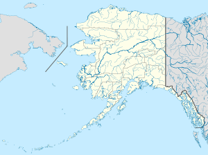 Whittier, Alaska Location in Alaska | |
| Coordinates: 60°46′27″N 148°40′40″W / 60.77417°N 148.67778°WCoordinates: 60°46′27″N 148°40′40″W / 60.77417°N 148.67778°W | |
| Country | United States |
| State | Alaska |
| Census Area | Valdez–Cordova |
| Incorporated | July 15, 1969[1] |
| Government | |
| • Type | Council-manager |
| • Mayor | Daniel Blair[2] |
| • State senator | Mike Dunleavy (R) |
| • State rep. | Jim Colver (R) |
| Area | |
| • Total | 19.7 sq mi (51.0 km2) |
| • Land | 12.5 sq mi (32.4 km2) |
| • Water | 7.2 sq mi (18.6 km2) |
| Elevation | 43 ft (13 m) |
| Population (2010) | |
| • Total | 220 |
| • Estimate (2015)[3] | 214 |
| • Density | 11/sq mi (4.3/km2) |
| Time zone | Alaska (AKST) (UTC-9) |
| • Summer (DST) | AKDT (UTC-8) |
| ZIP Code | 99693 |
| Area code | 907 |
| FIPS code | 02-84510 |
| GNIS feature ID | 1415757 |

Whittier is a city at the head of the Passage Canal in the U.S. state of Alaska, about 58 miles southeast of Anchorage.[4] The city is within the Valdez–Cordova Census Area. The 2015 population estimate was 214 people, almost all of whom live in a single building.[5] Whittier is also a port for the Alaska Marine Highway.[6]
History
.jpg)
The region now occupied by Whittier was once part of the portage route of the Chugach people native to Prince William Sound. Later, the passage was used by Russian and American explorers, and by prospecting miners during the gold rush.[4] The nearby Whittier glacier was named for American poet John Greenleaf Whittier in 1915, and the town eventually took the name as well.[7]
During World War II, the United States Army constructed a military facility, complete with port and railroad near Whittier Glacier and named the facility Camp Sullivan. The spur of the Alaska Railroad to Camp Sullivan was completed in 1943 and the port became the entrance for United States soldiers into Alaska.[8]
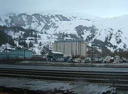
The two huge buildings that dominate the town were built after World War II. The 14-story Hodge Building (now Begich Towers) was completed in 1957 and contains 150 two- and three-bedroom apartments plus bachelor efficiency units. Dependent families and Civil Service employees were moved into this efficient high rise. The new Whittier School was connected by a tunnel at the base of the west tower so students could more easily and safely access school on days with bad weather. The building was named in honor of Colonel Walter William Hodge, who was a civil engineer and the commanding officer of 93rd Engineer Regiment on the Alcan Highway.[9]
The other main structure in town, the Buckner Building, was completed in 1953, and was called the "city under one roof". The Buckner Building was eventually abandoned and remains empty today. Buckner and Begich Towers were at one time the largest buildings in Alaska. The Begich Building is now a condominium, and along with the two-story private residence known as Whittier Manor, houses a majority of the town's residents.[10]
The port at Whittier was an active Army facility until 1960. In 1962, the U.S. Army Corps of Engineers constructed a petroleum products terminal, a pumping station and a 62-mile long, 8" pipeline to Anchorage in Whittier.[11][12]
On March 28, 1964, Whittier suffered over $10 million worth of damage in what is now known as the Good Friday earthquake. The earthquake remains the largest U.S. earthquake, measuring 9.2 on the Richter scale, and caused tsunamis along the West Coast of the U.S. The tsunami that hit Whittier reached a height of 13 m (43 ft) and killed 13 people.[13]
Whittier was incorporated in 1969. Today, it is an increasingly popular port of call for cruise ships. It is utilized by local operations and about 100 passenger mid-sized cruise ships. When the Anton Anderson Memorial Tunnel opened to public access in 2000, it became the first highway to connect Whittier to Anchorage and inner Alaska—previously, the only ways to reach the town had been rail, boat and plane.[14]
After the tunnel expanded access to Whittier, it began to be visited by larger cruise lines. It is the embarkation/debarkation point of one-way cruises from Anchorage to Vancouver by Princess Tours.[15] Whittier is also popular with tourists, photographers, outdoor enthusiasts, paddlers, hikers, sport fishermen, and hunters because of its abundance of wildlife and natural beauty.[16] Whittier is located within the Chugach National Forest, the second largest national forest in the U.S.[17]
Whittier is in the Chugach School District and has one school serving approximately 38 students from preschool through high school, according to the 2015-2016 enrollment numbers.[18]
Geography
Whittier is located at 60°46′27″N 148°40′40″W / 60.77417°N 148.67778°W (60.774174, −148.677649).[19] The only land access is through the Anton Anderson Memorial Tunnel, a mixed-use road and rail tunnel. The town is on the northeast shore of the Kenai Peninsula, at the head of Passage Canal, on the west side of Prince William Sound. It is 58 mi (93 km) southeast of Anchorage.[4]
According to the United States Census Bureau, the city has a total area of 19.7 square miles (51 km2), of which, 12.5 square miles (32 km2) of it is land and 7.2 square miles (19 km2) of it (36.36%) is water.
Climate
Whittier has a borderline subarctic (Dfc) and subpolar oceanic (Cfc) climate under the Köppen climate classification; and has an annual precipitation of 197.8 inches (5,024.12 mm). It is the wettest city in Alaska and the United States, receiving significantly more annual precipitation than Yakutat and Ketchikan which are the second and third wettest cities in Alaska, respectively. Whittier is located at the northern tip of the northernmost temperate rainforest.
| Climate data for Whittier, Alaska | |||||||||||||
|---|---|---|---|---|---|---|---|---|---|---|---|---|---|
| Month | Jan | Feb | Mar | Apr | May | Jun | Jul | Aug | Sep | Oct | Nov | Dec | Year |
| Average high °F (°C) | 31.1 (−0.5) |
32.6 (0.3) |
35.4 (1.9) |
43.2 (6.2) |
51.4 (10.8) |
59.7 (15.4) |
62.4 (16.9) |
60.9 (16.1) |
53.4 (11.9) |
42.8 (6) |
35.3 (1.8) |
32.7 (0.4) |
45.1 (7.3) |
| Average low °F (°C) | 22.9 (−5.1) |
24.3 (−4.3) |
25.8 (−3.4) |
32.6 (0.3) |
39.4 (4.1) |
46.6 (8.1) |
50.8 (10.4) |
49.7 (9.8) |
44.0 (6.7) |
34.5 (1.4) |
27.0 (−2.8) |
24.5 (−4.2) |
35.1 (1.7) |
| Average rainfall inches (mm) | 18.32 (465.3) |
15.63 (397) |
13.86 (352) |
15.37 (390.4) |
14.94 (379.5) |
9.83 (249.7) |
10.92 (277.4) |
14.73 (374.1) |
20.68 (525.3) |
19.92 (506) |
19.02 (483.1) |
23.45 (595.6) |
197.8 (5,024.1) |
| Average snowfall inches (cm) | 49.2 (125) |
48.6 (123.4) |
47.0 (119.4) |
21.7 (55.1) |
1.4 (3.6) |
0 (0) |
0 (0) |
0.0 (0) |
0.1 (0.3) |
6.5 (16.5) |
26.7 (67.8) |
56.8 (144.3) |
249.1 (632.7) |
| Source: http://www.whittieralaska.gov/docs/Whittier-Comprehensive-Plan-Update-2012.pdf | |||||||||||||
Demographics
| Historical population | |||
|---|---|---|---|
| Census | Pop. | %± | |
| 1950 | 627 | — | |
| 1960 | 809 | 29.0% | |
| 1970 | 130 | −83.9% | |
| 1980 | 198 | 52.3% | |
| 1990 | 243 | 22.7% | |
| 2000 | 182 | −25.1% | |
| 2010 | 220 | 20.9% | |
| Est. 2015 | 214 | [20] | −2.7% |
As of 2015, there were 214 people living in the city, with 288 available housing units.[22] Almost the entirety of this population lives within the 14-story Begich Towers.[23] The racial makeup of the city was 78.38% White, 4.05% Asian, 4.96% Native American, 3.60% Hawaiian or Pacific Islander, 5.41% Hispanic,and 9.01% from two or more races.[24] These numbers represent only census data, and an influx of tourists and visitors during summer months will likely represent further diversity and a much larger population.
There are 124 households in the town and the average household size is roughly 1.79 people, according to 2014 statistics. Of these households, 56 are family and 68 are non family. 40.30% of the population is married, and 32.34% are divorced. 51.78% of the population has children. [24]
The age distribution within the city shows that 13.96 percent of the population is under the age of 18, 3.15 percent is between the ages of 18 and 24, 23.87 percent is between the ages of 25 to 44, 52.25 percent is between the ages of 45 and 64, and 6.76 percent of the population is above the age of 65.[24]
The median income for a household in the city was $46,250 in 2014. The per capita income for the city was $31,624. Unemployment in Whittier was at a rate of 9.2 percent.[25]
Government
City government consists of a seven-member council with a mayor and six members representing seats (A to G).[26]
The small city has three key departments:
- Administration
- Public Safety
- Public Works and Public Utilities
Services
Whittier Police Department is the main police force in the community.
Whittier Fire Department is a volunteer fire and rescue service with mutual aid from neighboring departments.[27]
Transportation
Access to Whittier may be accomplished by various modes.
Harbor
There is a harbor and a deepwater port used by cruise ships and the Alaska Marine Highway.[28]
Airfield and Water Aerodrome
Whittier Airport (PAWR) is an airfield with one aircraft runway designated 4/22 (formerly 3/21) with a gravel surface measuring 1,480 by 60 feet (451 x 18 m).[29] There are no other facilities and the runway is not maintained in winter. For the 12-month period ending December 31, 2005, the airport had 700 aircraft operations, an average of 58 per month: 97 percent general aviation and 3 percent air taxi. At that time there were two single-engine aircraft based at this airport.[30] The runway was 500 feet longer but was damaged by the 1964 Good Friday earthquake.
The city also operates a seaplane dock.[31]
Roads
By land, access is through the Anton Anderson Memorial Tunnel.
Tunnel
Known by locals as the Whittier tunnel or the Portage tunnel, the Anton Anderson Memorial Tunnel is a tunnel through Maynard Mountain. It links the Seward Highway south of Anchorage with Whittier and is the only land access to the town. It is part of the Portage Glacier Highway and at 13,300 feet (4,050 m), is the second longest highway tunnel, and longest combined rail and highway tunnel in North America.[32]
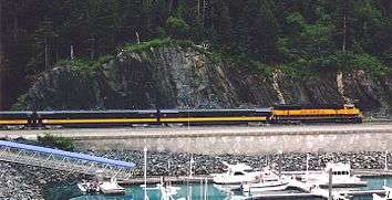
Alaska Rail connection
Whittier is Alaska Rail ARRC's connection to the rail systems in Canada and the Lower 48 states (by way of rail barge).[33]
References
- ↑ 1996 Alaska Municipal Officials Directory. Juneau: Alaska Municipal League/Alaska Department of Community and Regional Affairs. January 1996. p. 161.
- ↑ 2015 Alaska Municipal Officials Directory. Juneau: Alaska Municipal League. 2015. p. 165.
- ↑ "Annual Estimates of the Resident Population: April 1, 2010 to July 1, 2014". United States Census Bureau. Retrieved 2015-08-14.
- 1 2 3 "City of Whittier, Alaska". Whittier, Alaska. Retrieved 5 June 2016.
- ↑ "Whittier city, Alaska". American FactFinder; US Census Bureau. Retrieved 18 May 2015.
- ↑ "Alaska Marine Highway System: Route Guide". Alaska Marine Highway System. Retrieved 5 June 2016.
- ↑ "Whittier History". Cruise Port Insider. CruisePortInsider.com. Retrieved 5 June 2016.
- ↑ "Port of Whittier". World Port Source. Retrieved 5 June 2016.
- ↑ "The History and Military Significance of Whittier, Alaska". Archived from the original on 4 January 2015. Retrieved 8 January 2015.
- ↑ http://whittieralaska.gov/2005%20update%20Whittier%20Comp%20Plan.pdf page 11
- ↑ "The History and Military Significane of Whittier".
- ↑ Durand, Patrick. "The History and Military Significance of Whittier, Alaska" (PDF). Retrieved 5 June 2016.
- ↑ "Surge Wave Produced By 1964 Alaska Earthquake". March 28, 1964 Prince William Sound USA earthquake and tsunami. National Oceanic and Atmospheric Administration. Retrieved 6 June 2016.
- ↑ "Accomplishments". Anton Anderson Memorial Tunnel. Alaska Department of Transportation & Public Facilities. Retrieved 6 June 2016.
- ↑ "One-Way Cruises From Anchorage to Vancouver". Princess Cruises. Retrieved 6 June 2016.
- ↑ Blair, Daniel. "Letter from the Mayor". Whittier, Alaska. Retrieved 6 June 2016.
- ↑ "Announcements". Greater Whittier Chamber of Commerce. City of Whittier. Retrieved 6 June 2016.
- ↑ "Whittier Community School". Alaska Department of Education & Early Development. Retrieved 6 June 2016.
- ↑ "US Gazetteer files: 2010, 2000, and 1990". United States Census Bureau. 2011-02-12. Retrieved 2011-04-23.
- ↑ "Annual Estimates of the Resident Population for Incorporated Places: April 1, 2010 to July 1, 2015". Retrieved July 2, 2016.
- ↑ "Census of Population and Housing". Census.gov. Archived from the original on May 11, 2015. Retrieved June 4, 2015.
- ↑ "Search Results". United States Census Bureau. Retrieved 6 June 2016.
- ↑ "Around the Nation: Welcome To Whittier, Alaska, A Community Under One Roof". NPR. Jan 18, 2015. Retrieved Jan 1, 2016.
- 1 2 3 "Whittier, Alaska People". Sperling: Best Places. Retrieved 6 June 2016.
- ↑ "Whittier, Alaska Economy". Sperling's: Best Places. Retrieved 6 June 2016.
- ↑ Sundog Media. "Mayor, Council & Commissions - City of Whittier, Alaska - Gateway to Prince William Sound".
- ↑ Sundog Media. "Department of Public Safety - City of Whittier, Alaska - Gateway to Prince William Sound".
- ↑ "Whittier Harbor". City of Whittier, Alaska. Retrieved 6 June 2016.
- ↑ "AirNav: PAWR - Whittier Airport".
- ↑ FAA Airport Master Record for IEM (Form 5010 PDF), effective 2009-07-02.
- ↑ "Welcome to our New Website, Department of Commerce, Community, and Economic Development".
- ↑ ©Alaska Department of Transportation and Public Facilities, all rights reserved. "Whittier Tunnel, Transportation & Public Facilities, State of Alaska". Retrieved 8 January 2015.
- ↑ http://whittieralaska.gov/2005%20update%20Whittier%20Comp%20Plan.pdf page 66
External links
| Wikimedia Commons has media related to Whittier, Alaska. |
- Alaska Division of Community Advocacy - Community Information Summary
- City of Whittier
- Whittier Chamber of Commerce
- Virtual drive from Anchorage
- Whittier webcam
- The City Under One Roof: Buckner Building Sometimes Interesting. 18 Feb 2013
- Anton Anderson Memorial Tunnel official site
- Buckner Building – A Photo Guide
- Town Hall article on Whittier
- Welcome To Whittier, Alaska, A Community Under One Roof, NPR 18 January 2015
 |
Maynard Mountain | Passage Canal | | |
| Maynard Mountain Portage Lake |
|
|||
| ||||
| | ||||
| Portage Glacier | Blackstone Bay |
Municipalities and communities of Valdez–Cordova Census Area, Alaska, United States | ||
|---|---|---|
| Cities |  | |
| CDPs | ||
| Unincorporated communities | ||
| Ghost towns | ||