Kusilvak Census Area, Alaska
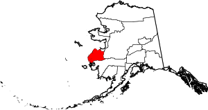
Kusilvak Census Area, formerly known as Wade Hampton Census Area, is a census area located in the U.S. state of Alaska. As of the 2010 census, the population was 7,459.[1] It is part of the unorganized borough and therefore has no borough seat. Its largest community is the city of Hooper Bay, on the Bering Sea coast.
The census area's per-capita income makes it the fourth poorest county-equivalent in the United States. In 2014, it had the highest percentage of unemployed people of any county or census area in the United States, at 23.7 percent.[2]
Name
The census area was originally named for Wade Hampton III, a South Carolina politician whose son-in-law, a territorial judge in Nome, posthumously named a mining district in western Alaska for him in 1913. The district eventually became the census area, retaining its name. Over the next century, the name became increasingly controversial, with Native residents and others arguing Hampton's name did not represent Alaska and that his personal history as a slave-holding Civil War general was a blemish on the region.[3] In July 2015, after a massacre in a historic black church in South Carolina generated a backlash against Confederate and white supremacist symbols nationwide,[4] Alaska Governor Bill Walker formally notified the U.S. Census Bureau that the census area was being renamed after the Kusilvak Mountains, its highest range.[5]
Geography
According to the U.S. Census Bureau, the census area has a total area of 19,673 square miles (50,950 km2), of which 17,081 square miles (44,240 km2) is land and 2,592 square miles (6,710 km2) (13.2%) is water.[6]
Adjacent boroughs and census areas
- Nome Census Area, Alaska - north
- Yukon-Koyukuk Census Area, Alaska - east
- Bethel Census Area, Alaska - south
National protected area
- Yukon Delta National Wildlife Refuge (part)
- Andreafsky Wilderness (part)
Demographics
| Historical population | |||
|---|---|---|---|
| Census | Pop. | %± | |
| 1960 | 3,128 | — | |
| 1970 | 3,917 | 25.2% | |
| 1980 | 4,665 | 19.1% | |
| 1990 | 5,791 | 24.1% | |
| 2000 | 7,028 | 21.4% | |
| 2010 | 7,459 | 6.1% | |
| Est. 2015 | 8,119 | [7] | 8.8% |
| U.S. Decennial Census[8] 1790-1960[9] 1900-1990[10] 1990-2000[11] 2010-2015[1] | |||
As of the census[12] of 2000, there were 7,028 people, 1,602 households, and 1,296 families residing in the census area. The population density was 0.35 people per square mile (0/km²). There were 2,063 housing units at an average density of /sq mi (0/km²). The racial makeup of the census area was 92.53% Native American, 4.74% White, 0.06% Black or African American, 0.10% Asian, 0.03% Pacific Islander, 0.03% from other races, and 2.52% from two or more races. 0.33% of the population were Hispanic or Latino of any race. 50.00% of the population reported speaking English at home, while 49.75% spoke Yup'ik Eskimo.[13]
In the 2006 American community survey, the Kusilvak Census Area had the largest increase in Hispanic population since 2000 with a 1572.73% increase.[14]
There were 1,602 households out of which 59.70% had children under the age of 18 living with them, 47.40% were married couples living together, 20.30% had a female householder with no husband present, and 19.10% were non-families. 16.00% of all households were made up of individuals and 1.80% had someone living alone who was 65 years of age or older. The average household size was 4.38 and the average family size was 4.95.
In the census area the population was spread out with 46.60% under the age of 18 (the highest such percentage among county equivalents in the United States), 9.70% from 18 to 24, 25.60% from 25 to 44, 13.10% from 45 to 64, and 5.00% who were 65 years of age or older. The median age was 20 years, making the Wade Hampton Census Area the youngest county in the United States.[15] For every 100 females there were 109.00 males. For every 100 females age 18 and over, there were 107.70 males.
The census area's per-capita income makes it one of the poorest places in the United States.
Communities
- Alakanuk
- Chevak
- Chuloonawick
- Emmonak
- Hooper Bay
- Kotlik
- Marshall
- Mountain Village
- Nunam Iqua (formerly Sheldon Point)
- Ohogamiut
- Pilot Station
- Pitkas Point
- Russian Mission
- Scammon Bay
- St. Mary's
See also
References
- 1 2 "State & County QuickFacts". United States Census Bureau. Retrieved May 18, 2014.
- ↑ "Labor Force Data by County, 2014 Annual Averages". U.S. Bureau of Labor Statistics. Retrieved July 2015. Check date values in:
|access-date=(help) - ↑ Demer, Lisa (April 25, 2015). "In Western Alaska, a push to rename district that honors slave-owning Confederate general". Alaska Dispatch News.
- ↑ "Confederate symbols under fire on Cap Hill". KTUU. June 23, 2015. Retrieved July 2, 2015.
- ↑ Demer, Lisa (July 2, 2015). "Wade Hampton no more: Alaska census area named for confederate officer gets new moniker". Alaska Dispatch News. Retrieved July 2, 2015.
- ↑ "US Gazetteer files: 2010, 2000, and 1990". United States Census Bureau. 2011-02-12. Retrieved 2011-04-23.
- ↑ "County Totals Dataset: Population, Population Change and Estimated Components of Population Change: April 1, 2010 to July 1, 2015". Retrieved July 2, 2016.
- ↑ "U.S. Decennial Census". United States Census Bureau. Retrieved May 18, 2014.
- ↑ "Historical Census Browser". University of Virginia Library. Retrieved May 18, 2014.
- ↑ "Population of Counties by Decennial Census: 1900 to 1990". United States Census Bureau. Retrieved May 18, 2014.
- ↑ "Census 2000 PHC-T-4. Ranking Tables for Counties: 1990 and 2000" (PDF). United States Census Bureau. Retrieved May 18, 2014.
- ↑ "American FactFinder". United States Census Bureau. Retrieved 2011-05-14.
- ↑
- ↑ http://www.census.gov/population/www/socdemo/hispanic/hispanic_pop_presentation.html
- ↑ G. Scott Thomas (31 August 2012). "Population extremes: The youngest and oldest places in America". The Business Journals.
External links
 |
Nome Census Area | | ||
| Bering Sea | |
Yukon-Koyukuk Census Area | ||
| ||||
| | ||||
| Bethel Census Area |
Municipalities and communities of Kusilvak Census Area, Alaska, United States | ||
|---|---|---|
| Cities | | |
| CDP | ||
Juneau (capital) | ||
| Topics |
|  |
| Society |
| |
| Regions | ||
| Largest cities | ||
| Boroughs | ||
| Census Areas | ||
Coordinates: 62°05′N 163°32′W / 62.09°N 163.53°W