Mount Magazine
| Mount Magazine | |
|---|---|
 Mount Magazine | |
| Highest point | |
| Elevation | 2,753 ft (839 m) NAVD 88[1] |
| Prominence | 2,435 ft (742 m) [2] |
| Listing | |
| Coordinates | 35°10′01″N 93°38′41″W / 35.167016203°N 93.644725919°WCoordinates: 35°10′01″N 93°38′41″W / 35.167016203°N 93.644725919°W [1] |
| Geography | |
 Mount Magazine | |
| Parent range | Ouachita Mountains |
| Topo map | USGS Blue Mountain |
| Geology | |
| Age of rock | Pennsylvanian |
| Mountain type | Sandstone |
| Climbing | |
| Easiest route | Hike |
Mount Magazine, officially named Magazine Mountain, is the highest mountain in the state of Arkansas and the site of Mount Magazine State Park.[3] The mountain is a flat-topped plateau with a sandstone cap rimmed by precipitous rock cliffs. Two peaks are situated atop the plateau, Signal Hill, which reaches 2,753 feet (839 m), and Mossback Ridge, which reaches 2,700 feet (823 m).
Location
Magazine Mountain sits in the midst of the Ozark National Forest in the Arkansas River Valley approximately 17 miles (27 km) south of Paris, Logan County, Arkansas, on Highway 309 (also known as the Mount Magazine Scenic Byway). The most scenic route to the top is a 10 miles (16 km) drive north from Havana, Arkansas. Views of Blue Mountain Lake will be enjoyed throughout the journey.
Climate
| Climate data for Mt Magazine, Arkansas (1948–1966) | |||||||||||||
|---|---|---|---|---|---|---|---|---|---|---|---|---|---|
| Month | Jan | Feb | Mar | Apr | May | Jun | Jul | Aug | Sep | Oct | Nov | Dec | Year |
| Record high °F (°C) | 76 (24) |
71 (22) |
80 (27) |
89 (32) |
94 (34) |
100 (38) |
104 (40) |
105 (41) |
98 (37) |
92 (33) |
78 (26) |
76 (24) |
105 (41) |
| Average high °F (°C) | 44.8 (7.1) |
48.6 (9.2) |
54.1 (12.3) |
66.6 (19.2) |
74.1 (23.4) |
82.3 (27.9) |
85.3 (29.6) |
84.9 (29.4) |
78.9 (26.1) |
68.8 (20.4) |
55.2 (12.9) |
47.5 (8.6) |
65.9 (18.8) |
| Average low °F (°C) | 27.3 (−2.6) |
30.1 (−1.1) |
34.7 (1.5) |
46.7 (8.2) |
56.7 (13.7) |
63.9 (17.7) |
66.9 (19.4) |
66.4 (19.1) |
59.8 (15.4) |
50.5 (10.3) |
37.5 (3.1) |
30.8 (−0.7) |
47.6 (8.7) |
| Record low °F (°C) | −9 (−23) |
−7 (−22) |
2 (−17) |
21 (−6) |
28 (−2) |
43 (6) |
53 (12) |
51 (11) |
39 (4) |
21 (−6) |
0 (−18) |
−5 (−21) |
−9 (−23) |
| Average precipitation inches (mm) | 3.94 (100.1) |
4.06 (103.1) |
5.38 (136.7) |
5.74 (145.8) |
6.24 (158.5) |
4.53 (115.1) |
6.25 (158.8) |
4.41 (112) |
3.85 (97.8) |
3.49 (88.6) |
3.47 (88.1) |
2.56 (65) |
53.92 (1,369.6) |
| Average snowfall inches (cm) | 2.2 (5.6) |
2.5 (6.4) |
0.7 (1.8) |
0.0 (0) |
0.0 (0) |
0.0 (0) |
0.0 (0) |
0.0 (0) |
0.0 (0) |
0.0 (0) |
0.7 (1.8) |
0.7 (1.8) |
6.8 (17.4) |
| Source: WRCC[4] | |||||||||||||
Name
The mountain gets its name from when French explorers were traveling through the area and a landslide occurred on the mountain. The noise from the landslide was so great that one explorer described it as the sound of an ammunition magazine exploding. The explorers then named the mountain "Magazine".
The Geographic Names Index System (GNIS) of the USGS indicates that the official name of this feature is Magazine Mountain, not "Mount Magazine". Although not a hard and fast rule, generally "Mount Xxxxx" is used for a peak and "Xxxx Mountain" is more frequently used for ridges, which better describes this feature. Magazine Mountain appears in the GNIS as a ridge,[5] with Signal Hill identified as its summit.[6] "Mount Magazine" is the name used by the Arkansas Department of Parks and Tourism, which follows what the locals have used since the area was first settled. All four of the guidebooks published to date on the subject of state highpoints have used Magazine Mountain.
The mountain is often called "the highest point between the Alleghenies and the Rockies", but there are areas in Kansas, Nebraska, North Dakota, Oklahoma, Texas, and South Dakota with higher elevations.[7]
Gallery
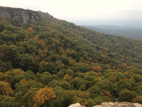
 View from the summit of Mount Magazine looking northwest
 Sign on Signal Hill
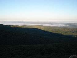
 View south from Mount Magazine
 Mt Magazine as seen from Petit Jean Mountain
See also
References
- 1 2 "MAG". NGS data sheet. U.S. National Geodetic Survey. Retrieved 2008-12-16.
- ↑ "Magazine Mountain, Arkansas". Peakbagger.com. Retrieved 2012-10-17.
- ↑ "Mount Magazine State Park". Arkansas Department of Parks and Tourism. Retrieved January 2, 2013.
- ↑ "Western Regional Climate Center". Retrieved August 12, 2016.
- ↑ "Magazine Mountain". Geographic Names Information System. United States Geological Survey. Retrieved January 2, 2013.
- ↑ "Signal Hill". Geographic Names Information System. United States Geological Survey. Retrieved January 2, 2013.
- ↑ "Arkansas's Highpoint Information" (PDF). Arkansas Department of Parks and Tourism. Retrieved January 2, 2013.