George Parks Highway
| ||||
|---|---|---|---|---|
| Route information | ||||
| Maintained by Alaska DOT&PF | ||||
| Length: | 323 mi (520 km) | |||
| Existed: | 1970s – present | |||
| Major junctions | ||||
| South end: |
| |||
|
| ||||
| North end: |
| |||
| Highway system | ||||
| ||||


The George Parks Highway (numbered Interstate A-4 and Alaska Route 3), usually called simply the Parks Highway, runs 323 miles (520 km) from the Glenn Highway 35 miles (56 km) north of Anchorage to Fairbanks in the Alaska Interior. The highway, originally known as the Anchorage-Fairbanks Highway, was completed in 1971, and given its current name in 1975.

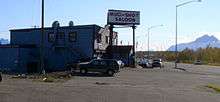
The highway, which mostly parallels the Alaska Railroad, is one of the most important roads in Alaska. It is the main route between Anchorage and Fairbanks (Alaska's two largest metropolitan areas), the principal access to Denali National Park and Preserve and Denali State Park, and the main highway in the Matanuska-Susitna Valley.
It is a common misconception that the name "Parks Highway" comes from the road's proximity to the Denali state and national parks; it is in fact in honor of George Alexander Parks, governor of the Territory of Alaska from 1925 to 1933.[1] However, the aptness of the name was recognized when it was chosen.
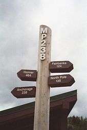
Mileposts along the Parks Highway do not begin with 0 (zero). Instead, they begin with Mile 35 (km 56), continuing the milepost numbering of the Glenn Highway where the two highways intersect near Palmer. The 0 (zero) mile marker for the Glenn Highway is at its terminus in downtown Anchorage at the intersection of East 5th Avenue and Gambell Street. Thus mileposts along the Parks Highway reflect distance from Anchorage, which is not actually on the Parks Highway.
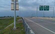
There are two sections of the highway that are built to freeway standards. These include an area near the highway's intersection with the Glenn Highway in Palmer and a stretch known as the Robert J. Mitchell Expressway in Fairbanks leading to the highway's junction with the Richardson Highway (AK 2).
Exit list


In the "Mile" column, the first number is the actual mileage of the Parks Highway, and the second mile is based on the mileposts along the highway itself.
All exits are unnumbered.
| Borough | Location | mi | km | Destinations | Notes |
|---|---|---|---|---|---|
| Matanuska-Susitna | Gateway | 0.00– 35 | 0.00– 56 | Interchange, East end of Wasilla freeway section | |
| Trunk Road | Interchange | ||||
| 2.58– 37.58 | 4.15– 60.48 | Fairview Loop / Hyer Road | Interchange | ||
| Lakes | Seward-Meridian Parkway | Interchange | |||
| Wasilla | 3.66– 38.66 | 5.89– 62.22 | West end of Wasilla freeway section | ||
| Palmer-Wasilla Highway | |||||
| Museum Drive | To New Wasilla Airport | ||||
| Houston | Big Lake Road | To Big Lake | |||
| Denali State Park | Entering Denali State Park | ||||
| Exiting Denali State Park | |||||
| Denali | Cantwell | Denali Highway continues a short distance west to the Cantwell Airport. | |||
| Denali National Park and Preserve | Entrance to Denali National Park and Preserve | ||||
| Fairbanks North Star | College | West end of Fairbanks freeway section | |||
| 317.65– 352.62 | 511.21– 567.49 | Geist Road / Chena Pump Road—University of Alaska | Interchange | ||
| 318.81– 353.81 | 513.07– 569.40 | Airport Way west— Fairbanks International Airport | Interchange; Beginning of the Robert Mitchell Expressway | ||
| 318.81– 353.81 | 513.07– 569.40 | Airport Way east | Interchange; Southbound exit is via Old Airport Road | ||
| 319.73– 354.73 | 514.56– 570.88 | University Avenue | |||
| Fairbanks | 321.94– 356.94 | 518.11– 574.44 | Peger Road | ||
| 322– 357.95 | 518– 576.06 | Lathrop Street | |||
| Cushman Street / Old Richardson Highway | Interchange; Northbound exit and southbound entrance; Access via 30th Avenue from northbound roadway and via 28th Avenue from southbound roadway | ||||
| 323– 358 | 520– 576 | Interchange; Northbound exit and southbound entrance | |||
| 1.000 mi = 1.609 km; 1.000 km = 0.621 mi | |||||
References
- ↑ "Parks Highway". Anchorage Daily News. July 16, 1975. p. 4.
External links
| Signed | |||||||||||
|---|---|---|---|---|---|---|---|---|---|---|---|
| Unsigned | |||||||||||
| Lists |
| ||||||||||
Major Interstates highlighted | |||||||||||