Francs Peak
| Francs Peak | |
|---|---|
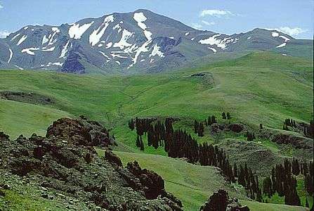 Francs Peak from Haymaker Pass | |
| Highest point | |
| Elevation | 13,158 ft (4,011 m) [1] |
| Prominence | 4,056 ft (1,236 m) [1] |
| Listing | |
| Coordinates | 43°57′41″N 109°19′51″W / 43.96139°N 109.33083°WCoordinates: 43°57′41″N 109°19′51″W / 43.96139°N 109.33083°W [2] |
| Geography | |
 Francs Peak | |
| Parent range | Absaroka Range |
| Topo map | USGS Francs Peak |
| Climbing | |
| Easiest route | Hike |
Francs Peak (13,158 feet (4,011 m)) is the highest point in the Absaroka Range which extends from north central Wyoming into south central Montana, in the United States. It is located in the Washakie Wilderness of Shoshone National Forest, and the peak is also the highest point in Park County, Wyoming, which includes much of Yellowstone National Park.[1][3] It was named after Otto Franc, a cattle baron and homesteader in the Big Horn Basin.[4]
See also
- 4000 meter peaks of North America
- Central Rocky Mountains
- Mountain peaks of North America
- Mountain peaks of the Rocky Mountains
- Mountain peaks of the United States
References
- 1 2 3 "Francs Peak, Wyoming". Peakbagger.com. Retrieved October 5, 2014.
- ↑ "Francs Peak". Geographic Names Information System. United States Geological Survey. Retrieved October 5, 2014.
- ↑ Francs Peak, WY (Map). TopoQwest (United States Geological Survey Maps). Retrieved October 5, 2014.
- ↑ "Francs Peak". SummitPost.org. Retrieved October 5, 2014.
External links
Cheyenne (capital) | |
| Topics |
|
| Society |
|
| Regions | |
| Cities | |
| Counties | |
This article is issued from Wikipedia - version of the 1/18/2016. The text is available under the Creative Commons Attribution/Share Alike but additional terms may apply for the media files.