List of Ultras of the Rocky Mountains
Further information: List of mountain peaks of the Rocky Mountains
See also: List of the major 4000-meter summits of the Rocky Mountains and List of the major 100-kilometer summits of the Rocky Mountains

Mount Robson in British Columbia is the highest peak of the Canadian Rockies and the most prominent summit of the Rocky Mountains.
The following sortable table comprises the 31 ultra-prominent summits of the Rocky Mountains of North America. Each of these peaks has at least 1500 meters (4921 feet) of topographic prominence.[1]
The summit of a mountain or hill may be measured in three principal ways:
- The topographic elevation of a summit measures the height of the summit above a geodetic sea level.[2][3]
- The topographic prominence of a summit is a measure of how high the summit rises above its surroundings.[4][3]
- The topographic isolation (or radius of dominance) of a summit measures how far the summit lies from its nearest point of equal elevation.[5]
Ultra-prominent summits
Main article: List of the ultra-prominent summits of North America
Of these 31 ultra-prominent summits of the Rocky Mountains, ten are located in British Columbia, nine in Alberta, four in Montana, three in Colorado, three in Utah, three in Wyoming, and two in Idaho. Three of these peaks lie on the Alberta-British Columbia border.
Gallery
- 1. Mount Robson in British Columbia is the highest summit of the Canadian Rockies and the most prominent summit of the Rocky Mountains.
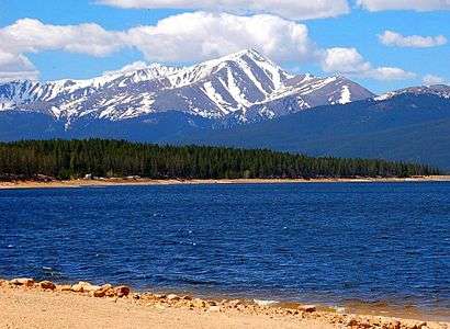 2. Mount Elbert in the Sawatch Range is the highest summit of the Rocky Mountains and the U.S. State of Colorado.
 3. Mount Columbia on the Great Divide between Alberta and British Columbia is the highest point of the Canadian Province of Alberta.
 4. Cloud Peak is the highest summit of the Big Horn Mountains of Wyoming.
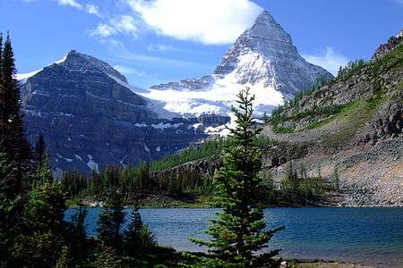 6. Mount Assiniboine on the Great Divide between Alberta and British Columbia is the highest summit of the Southern Continental Ranges.
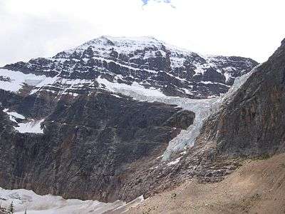 7. Mount Edith Cavell is the highest summit of the South Jasper Ranges of Alberta.
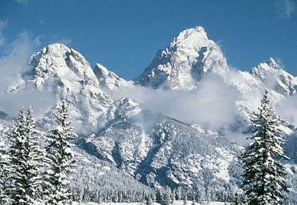 8. Grand Teton is the highest summit of the Teton Range of Wyoming.
 10. Mount Goodsir is the highest peak of the Ottertail Range of British Columbia.
 14. Mount Hector is the highest summit of the Murchison Group of Alberta.
 17. Crazy Peak is the highest summit of the Crazy Mountains of Montana.
 18. McDonald Peak is the highest summit of the Mission Mountains of Montana.
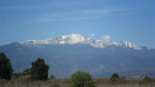 19. Pikes Peak in Colorado was the inspiration for America the Beautiful.
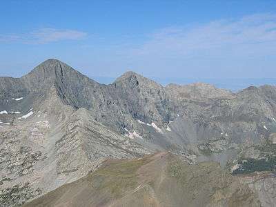 25. Blanca Peak is the highest summit of the Sangre de Cristo Mountains of Colorado.
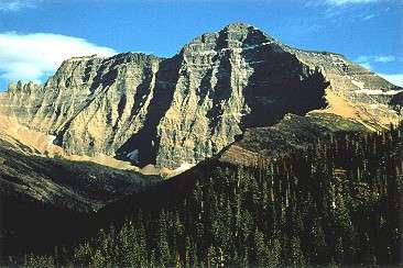 28. Mount Cleveland is the highest summit of the Lewis Range of Montana.
See also
- Rocky Mountains
- Geology of the Rocky Mountains
- Category:Rocky Mountains
- Geology of the Rocky Mountains
- List of mountain peaks of North America
- List of mountain peaks of Greenland
- List of mountain peaks of Canada
- List of mountain peaks of the Rocky Mountains
- List of the major 4000-meter summits of the Rocky Mountains
- List of the major 3000-meter summits of the Rocky Mountains
- List of the ultra-prominent summits of the Rocky Mountains
- List of the major 100-kilometer summits of the Rocky Mountains
- List of extreme summits of the Rocky Mountains
- List of mountain peaks of the United States
- List of mountain peaks of México
- List of mountain peaks of Central America
- List of mountain peaks of the Caribbean
- Physical geography
References
- ↑ This article defines a significant summit as a summit with at least 100 meters (328.1 feet) of topographic prominence, and a major summit as a summit with at least 500 meters (1640 feet) of topographic prominence. An ultra-prominent summit is a summit with at least 1500 meters (4921 feet) of topographic prominence.
- ↑ All elevations in the 48 states of the contiguous United States include an elevation adjustment from the National Geodetic Vertical Datum of 1929 (NGVD 29) to the North American Vertical Datum of 1988 (NAVD 88). For further information, please see this United States National Geodetic Survey note.
- 1 2 If the elevation or prominence of a summit is calculated as a range of values, the arithmetic mean is shown.
- ↑ The topographic prominence of a summit is the topographic elevation difference between the summit and its highest or key col to a higher summit. The summit may be near its key col or quite far away. The key col for Denali in Alaska is the Isthmus of Rivas in Nicaragua, 7642 kilometers (4749 miles) away.
- ↑ The topographic isolation of a summit is the great-circle distance to its nearest point of equal elevation.
- ↑ The summit of Mount Robson is the highest point of the Canadian Rockies.
- ↑ Mount Robson is the easternmost summit of its elevation in Canada and the northernmost and westernmost summit of its elevation in the Rocky Mountains.
- ↑ "Mount Robson". Peakbagger.com. Retrieved 4 May 2016.
- ↑ "Mount Robson". Bivouac.com. Retrieved 4 May 2016.
- ↑ The summit of Mount Elbert is the highest point of the U.S. State of Colorado, the Rocky Mountains of North America, and the entire Mississippi River drainage basin.
- ↑ "MOUNT ELBERT". Datasheet for NGS Station KL0637. United States National Geodetic Survey. Retrieved 4 May 2016.
- ↑ "Mount Elbert". Peakbagger.com. Retrieved 4 May 2016.
- ↑ "Mount Elbert". Bivouac.com. Retrieved 4 May 2016.
- ↑ Mount Columbia on the Great Divide between British Columbia and Alberta is the highest point of the Columbia Icefield, the Province of Alberta, and the entire Beaufort Sea Drainage basin.
- ↑ "Mount Columbia". Peakbagger.com. Retrieved 4 May 2016.
- ↑ "Mount Columbia". Bivouac.com. Retrieved 4 May 2016.
- ↑ The summit of Cloud Peak is the highest point of the Bighorn Mountains.
- ↑ Cloud Peak is the northernmost 4000-meter (13,123-foot) summit of the Rocky Mountains.
- ↑ "CLOUD PEAK". Datasheet for NGS Station PW0524. United States National Geodetic Survey. Retrieved 4 May 2016.
- ↑ "Cloud Peak". Peakbagger.com. Retrieved 4 May 2016.
- ↑ "Cloud Peak". Bivouac.com. Retrieved 4 May 2016.
- ↑ The summit of Gannett Peak is the highest point of the Wind River Range, the U.S. State of Wyoming, and the central Rocky Mountains.
- ↑ Gannett Peak is the northernmost and westernmost summit of its elevation in the Rocky Mountains.
- ↑ "GANNETT PEAK CAIRN". Datasheet for NGS Station OW0356. United States National Geodetic Survey. Retrieved 4 May 2016.
- ↑ "Gannett Peak". Peakbagger.com. Retrieved 4 May 2016.
- ↑ "Gannett Peak". Bivouac.com. Retrieved 4 May 2016.
- ↑ Mount Assiniboine is the southernmost and easternmost summit of its elevation in Canada.
- ↑ "Mount Assiniboine". Peakbagger.com. Retrieved 4 May 2016.
- ↑ "Mount Assiniboine". Bivouac.com. Retrieved 4 May 2016.
- ↑ "Mount Edith Cavell". Peakbagger.com. Retrieved 4 May 2016.
- ↑ "Mount Edith Cavell". Bivouac.com. Retrieved 4 May 2016.
- ↑ The summit of Grand Teton is the highest point of the Teton Range.
- ↑ Grand Teton is the northernmost and westernmost 4000-meter (13,123-foot) summit of the Rocky Mountains.
- ↑ "GRAND TETON". Datasheet for NGS Station OX0838. United States National Geodetic Survey. Retrieved 4 May 2016.
- ↑ "Grand Teton". Peakbagger.com. Retrieved 4 May 2016.
- ↑ "Grand Teton". Bivouac.com. Retrieved 4 May 2016.
- ↑ The summit of Kings Peak is the highest point of the Uinta Mountains, the U.S. State of Utah, and the western Rocky Mountains.
- ↑ The elevation of Kings Peak includes an adjustment of +1.807 m (+5.93 ft) from NGVD 29 to NAVD 88.
- ↑ "Kings Peak". Peakbagger.com. Retrieved 4 May 2016.
- ↑ "Kings Peak". Bivouac.com. Retrieved 4 May 2016.
- ↑ The summit of Mount Goodsir is the highest point of the Ottertail Range.
- ↑ "Mount Goodsir". Peakbagger.com. Retrieved 4 May 2016.
- ↑ "Mount Goodsir". Bivouac.com. Retrieved 4 May 2016.
- ↑ The summit of Borah Peak is the highest point of the Lost River Range and the U.S. State of Idaho.
- ↑ "BEAUTY RESET". Datasheet for NGS Station PZ0770. United States National Geodetic Survey. Retrieved 4 May 2016.
- ↑ "Borah Peak". Peakbagger.com. Retrieved 4 May 2016.
- ↑ "Borah Peak". Bivouac.com. Retrieved 4 May 2016.
- ↑ Mount Harrison is the southernmost and easternmost 3000-meter (9843-foot) summit of Canada.
- ↑ "Mount Harrison". Peakbagger.com. Retrieved 4 May 2016.
- ↑ "Mount Harrison". Bivouac.com. Retrieved 4 May 2016.
- ↑ Mount Sir Alexander is the northernmost and westernmost 3000-meter (9843-foot) summit and ultra-prominent summit of the Rocky Mountains.
- ↑ "Mount Sir Alexander". Peakbagger.com. Retrieved 4 May 2016.
- ↑ "Mount Sir Alexander". Bivouac.com. Retrieved 4 May 2016.
- ↑ "Mount Hector". Peakbagger.com. Retrieved 4 May 2016.
- ↑ "Mount Hector". Bivouac.com. Retrieved 4 May 2016.
- ↑ Whitehorn Mountain is the northernmost and westernmost summit of its elevation in the Rocky Mountains.
- ↑ "Whitehorn Mountain". Peakbagger.com. Retrieved 4 May 2016.
- ↑ "Whitehorn Mountain". Bivouac.com. Retrieved 4 May 2016.
- ↑ Mount Chown is the northernmost and westernmost summit of its elevation in the Rocky Mountains.
- ↑ "Mount Chown". Peakbagger.com. Retrieved 4 May 2016.
- ↑ "Mount Chown". Bivouac.com. Retrieved 4 May 2016.
- ↑ The summit of Crazy Peak is the highest point of the Crazy Mountains.
- ↑ The elevation of Crazy Peak includes an adjustment of +1.421 m (+4.66 ft) from NGVD 29 to NAVD 88.
- ↑ "Crazy Peak". Peakbagger.com. Retrieved 4 May 2016.
- ↑ "Crazy Peak". Bivouac.com. Retrieved 4 May 2016.
- ↑ The summit of McDonald Peak is the highest point of the Mission Range.
- ↑ The elevation of McDonald Peak includes an adjustment of +1.318 m (+4.32 ft) from NGVD 29 to NAVD 88.
- ↑ "McDonald Peak". Peakbagger.com. Retrieved 4 May 2016.
- ↑ "McDonald Peak". Bivouac.com. Retrieved 4 May 2016.
- ↑ Pikes Peak is the easternmost 14,000-foot (4267-meter) summit and ultra-prominent summit of the Rocky Mountains. Pikes Peak was the inspiration for the lyrics of America the Beautiful.
- ↑ "PIKES PEAK". Datasheet for NGS Station JK1242. United States National Geodetic Survey. Retrieved 4 May 2016.
- ↑ "Pikes Peak". Peakbagger.com. Retrieved 4 May 2016.
- ↑ "Pikes Peak". Bivouac.com. Retrieved 4 May 2016.
- ↑ The summit of Mount Nebo is the highest point of the Wasatch Range.
- ↑ The elevation of Mount Nebo includes an adjustment of +1.395 m (+4.58 ft) from NGVD 29 to NAVD 88.
- ↑ "Mount Nebo". Peakbagger.com. Retrieved 4 May 2016.
- ↑ "Mount Nebo". Bivouac.com. Retrieved 4 May 2016.
- ↑ The summit of Snowshoe Peak is the highest point of the Cabinet Mountains.
- ↑ The elevation of Snowshoe Peak includes an adjustment of +1.367 m (+4.48 ft) from NGVD 29 to NAVD 88.
- ↑ "Snowshoe Peak". Peakbagger.com. Retrieved 4 May 2016.
- ↑ "Snowshoe Peak". Bivouac.com. Retrieved 4 May 2016.
- ↑ "Jeanette Peak". Peakbagger.com. Retrieved 4 May 2016.
- ↑ "Jeanette Peak". Bivouac.com. Retrieved 4 May 2016.
- ↑ The summit of Mount Forbes is the highest point of the entire Hudson Bay drainage basin.
- ↑ Mount Forbes is the easternmost summit of its elevation in Canada.
- ↑ "Mount Forbes". Peakbagger.com. Retrieved 4 May 2016.
- ↑ "Mount Forbes". Bivouac.com. Retrieved 4 May 2016.
- ↑ The summit of Diamond Peak is the highest point of the Lemhi Range.
- ↑ "DIAMOND RESET". Datasheet for NGS Station PZ0750. United States National Geodetic Survey. Retrieved 4 May 2016.
- ↑ "Diamond Peak". Peakbagger.com. Retrieved 4 May 2016.
- ↑ "Diamond Peak". Bivouac.com. Retrieved 4 May 2016.
- ↑ The summit of Blanca Peak is the highest point of the Sangre de Cristo Mountains and the entire Rio Grande drainage basin.
- ↑ Blanca Peak is the southernmost ultra-prominent summit of the Rocky Mountains.
- ↑ The elevation of Blanca Peak includes an adjustment of +1.755 m (+5.76 ft) from NGVD 29 to NAVD 88.
- ↑ "Blanca Peak". Peakbagger.com. Retrieved 4 May 2016.
- ↑ "Blanca Peak". Bivouac.com. Retrieved 4 May 2016.
- ↑ The summit of Mount Timpanogos is the highest point of the central Wasatch Range.
- ↑ "TIMPANOGOS". Datasheet for NGS Station LO0769. United States National Geodetic Survey. Retrieved 4 May 2016.
- ↑ "Mount Timpanogos". Peakbagger.com. Retrieved 4 May 2016.
- ↑ "Mount Timpanogos". Bivouac.com. Retrieved 4 May 2016.
- ↑ The summit of Mount Fryatt is the highest point of the Hooker Icefield.
- ↑ "Mount Fryatt". Peakbagger.com. Retrieved 4 May 2016.
- ↑ "Mount Fryatt". Bivouac.com. Retrieved 4 May 2016.
- ↑ The summit of Mount Cleveland is the highest point of the Lewis Range.
- ↑ "CLEVELAND". Datasheet for NGS Station TM1009. United States National Geodetic Survey. Retrieved 4 May 2016.
- ↑ "Mount Cleveland". Peakbagger.com. Retrieved 4 May 2016.
- ↑ "Mount Cleveland". Bivouac.com. Retrieved 4 May 2016.
- ↑ The summit of Mount Temple is the highest point of the Bow Range.
- ↑ "Mount Temple". Peakbagger.com. Retrieved 4 May 2016.
- ↑ "Mount Temple". Bivouac.com. Retrieved 4 May 2016.
- ↑ Mount Ida is the northernmost 3000-meter (9843-foot) summit and ultra-promoinent summit of the Rocky Mountains.
- ↑ "Mount Ida". Peakbagger.com. Retrieved 4 May 2016.
- ↑ "Mount Ida". Bivouac.com. Retrieved 4 May 2016.
- ↑ Mount Joffre is the easternmost summit of its elevation in Canada.
- ↑ "Mount Joffre". Peakbagger.com. Retrieved 4 May 2016.
- ↑ "Mount Joffre". Bivouac.com. Retrieved 4 May 2016.
External links
- Natural Resources Canada (NRC)
- United States Geological Survey (USGS)
- United States National Geodetic Survey (NGS)
- Bivouac.com
- Peakbagger.com
- Peaklist.org
- Peakware.com
- Summitpost.org
Coordinates: 53°06′38″N 119°09′24″W / 53.1105°N 119.1566°W
This article is issued from Wikipedia - version of the 5/4/2016. The text is available under the Creative Commons Attribution/Share Alike but additional terms may apply for the media files.