Kerrville, Texas
| Kerrville, Texas | |
|---|---|
| City | |
|
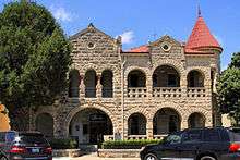
Kerrville City Hall | |
| Nickname(s): The Ville,KTown | |
| Motto: Lose Your Heart To The Hills | |
 Location of Kerrville, Texas | |
| Coordinates: 30°2′51″N 99°8′26.1″W / 30.04750°N 99.140583°WCoordinates: 30°2′51″N 99°8′26.1″W / 30.04750°N 99.140583°W | |
| Country |
|
| State |
|
| County | Kerr |
| Government | |
| • Type | Council-Manager |
| • City Council |
Mayor Bonnie White, succeeds Jack Pratt, Jr. (2016) City council members Gary Stork and Gene Allen (re-elected 2016) |
| • City Manager | Todd Parton |
| Area | |
| • Total | 16.9 sq mi (43.9 km2) |
| • Land | 16.7 sq mi (43.3 km2) |
| • Water | 0.2 sq mi (0.6 km2) |
| Elevation | 1,637 ft (499 m) |
| Population (2010) | |
| • Total | 22,347 |
| • Density | 1,222.5/sq mi (472.0/km2) |
| Time zone | Central (CST) (UTC-6) |
| • Summer (DST) | CDT (UTC-5) |
| ZIP codes | 78028-78029 |
| Area code(s) | 830 |
| FIPS code | 48-39040[1] |
| GNIS feature ID | 1339058[2] |
| Website | / Kerrvilletx.gov |

Kerrville is a city in Kerr County, Texas, United States.[3] It is the county seat of Kerr County. The population was 20,425 at the 2000 census. In 2009, the population was 22,826.[4] Kerrville is named after James Kerr, a major in the Texas Revolution, and friend of settler-founder Joshua Brown, who settled in the area to start a shingle-making camp.[5]
Being nestled in the hills of Texas Hill Country, Kerrville is best known for its beautiful parks that line the Guadalupe River, which runs directly through the city; other features include its nearby youth summer camps, hunting ranches, and RV parks. It is also the home of Texas' Official State Arts & Crafts Fair, the Kerrville Folk Festival, Mooney Aviation Company,[6] James Avery Jewelry, Kerrville Bus Company,[7] and Schreiner University. The Museum of Western Art (founded 1983) features the work of living artists specializing in the themes of the American West.
History
.jpg)
Archeological evidence suggests that humans dwelled in the area known as Kerrville as early as 10,000 years ago. The early modern residents were successful shinglemakers whose mercantile business became a hub that served the middle and upper Hill Country area in the late 1840s. One of the earliest shinglemakers was Joshua D. Brown. With his family, Joshua Brown had led several other families on an exploration of the Guadalupe Valley. These early pioneers organized their settlements near a bluff just north of the Guadalupe River in the eastern half today's county line. The settlement was referred to as "Brownsborough," but after the area was formally platted in 1856 by James Kerr, a major in the Texas Revolution, the settlement was formally known as "Kerrville" and maintained a county seat with Texas.
Starting in 1857, a German master-miller named Christian Dietert and millwright Balthasar Lich started a large grist and saw mill on the bluff. This mill established a permanent source of power and protection from floods, and became the most extensive operation of its kind in the Hill Country area west of New Braunfels and San Antonio. Soon afterwards, Charles A. Schreiner rode Kerrville's newly found popularity, by serving Kerrville's mercantile needs. Schreiner established a family-run empire that helped build Kerrville's early prosperity by owning almost all of Kerrville's business sectors, including freighting enterprises, retail, wholesale, banking, ranching, marketing, and brokering operations. Schreiner's elegant downtown home, a Romanesque stone structure at 226 Earl Garrett Street, is the site of the Hill Country Museum in downtown Kerrville.
The Civil War slowed Kerrville's development, but with the start of the Reconstruction era, Kerrville's economic boom and ethnic diversification continued anew as demand grew in San Antonio for lumber, produce, and craftsmen. Kerrville's boom was also catalyzed by the combination of the cessation of Indian raids and the expansion into the business of cattle, sheep, and goat ranching. Cattle drives punctuated the boom-years of the late 1880s and the 1890s. In 1887, the San Antonio and Aransas Pass Railway reached Kerrville, and in 1889 the town incorporated, with an "Aldermanic" form of city government.
The Kerrville Water Works Company began to provide water for town dwellers in 1894. Telephone service was introduced in 1896, and the city began to pave streets in 1912. Kerrville adopted a "commission" form of city government in 1917, then changed to the "city-manager" form in 1928. In 1942, the town adopted a home-rule charter, while continuing with a city manager. Kerrville has displayed steady population growth throughout the 20th century, increasing from 1,423 residents in 1900 to 2,353 in 1920, 5,572 in 1940, 8,901 in 1960, and 15,276 in 1980. Its economic base has diversified and broadened through business, agriculture, light manufacturing, health care, transportation, services, education, the arts, and tourism. By the mid-1990s the Wall Street Journal described Kerrville as one of the wealthiest small towns in America. By 1995, the city's official population was still under 18,000, with another 20,000 people in relatively affluent residential areas south of the river and in the rest of the county. In 2000, the population reached 20,425. Much of the growth in population included retirees and young professionals and semiprofessionals; for many years Kerrville also experienced significant out-migration of young adults raised in the area.
Geography
Kerrville is located at (20000)_region:US-TX 30°02′47″N 99°8′26″W / 30.04639°N 99.14056°W.[8] This is 58 miles (93 km) northwest of San Antonio and 85 miles (137 km) west of Austin.
According to the United States Census Bureau, the city has a total area of 16.9 square miles (44 km2). 16.7 square miles (43 km2) of it is land and 0.2 square miles (0.52 km2) of it (1.36%) is covered by water.
Demographics
| Historical population | |||
|---|---|---|---|
| Census | Pop. | %± | |
| 1880 | 156 | — | |
| 1890 | 1,044 | 569.2% | |
| 1900 | 1,423 | 36.3% | |
| 1910 | 1,843 | 29.5% | |
| 1920 | 2,353 | 27.7% | |
| 1930 | 4,546 | 93.2% | |
| 1940 | 5,572 | 22.6% | |
| 1950 | 7,691 | 38.0% | |
| 1960 | 8,901 | 15.7% | |
| 1970 | 12,672 | 42.4% | |
| 1980 | 15,276 | 20.5% | |
| 1990 | 17,384 | 13.8% | |
| 2000 | 20,425 | 17.5% | |
| 2010 | 22,347 | 9.4% | |
| Est. 2015 | 23,136 | [9] | 3.5% |
As of the census[1] of 2000, 20,425 people, 8,563 households, and 5,411 families resided in the city. The population density was 1,222.5 people per square mile (471.9/km2). The 9,477 housing units averaged 567.2 per square mile (219.0/km2). The racial makeup of the city was 85.89% White, 2.99% African American, 0.55% Native American, 0.57% Asian, 0.08% Pacific Islander, 8.20% from other races, and 1.73% from two or more races. Hispanics or Latinos of any race were 22.73% of the population.
Of the 8,563 households, 8.9% had children under the age of 18 living with them, 49.8% were married couples living together, 10.2% had a female householder with no husband present, and 36.8% were not families. About 33.1% of all households were made up of individuals, and 19.4% had someone living alone who was 65 years of age or older. The average household size was 2.21 and the average family size was 2.79.
In the city, the population was distributed as 21.0% under the age of 18, 8.0% from 18 to 24, 21.3% from 25 to 44, 20.4% from 45 to 64, and 29.3% who were 65 years of age or older. The median age was 45 years. For every 100 females, there were 87 males. For every 100 females age 18 and over, there were 83.0 males.[11]
The median income for a household in the city was $32,085, and for a family was $38,979. Males had a median income of $27,555 versus $19,923 for females. The per capita income for the city was $20,193. About 11.7% of families and 15.6% of the population were below the poverty line, including 25.8% of those under age 18 and 7.8% of those age 65 or over.[11]
Culture
Kerrville Folk Festival is an annual summer festival which features folk musicians from around the country and Canada.[12]
Infrastructure
Nonprofit/service organizations
The TaxExemptWorld.com website, which compiles Internal Revenue Service data, reported that in 2013, 465 distinct, active, tax exempt/nonprofit organizations in Kerrville, excluding credit unions, had a total income of $414.4 million and assets of $958.8 million.[13] One example of a performing arts nonprofit organization in Kerrville would be Art 2 Heart.
Transportation

Interstates
State highways
 SH 16 (Medina Highway, Sidney Baker Highway, Fredericksburg Road)
 SH 27 (Junction Highway, Main Street, Broadway Avenue)
 SH 173 (Bandera Highway)
Loops
 Loop 534 (Veterans Highway)
Farm-to-Market roads
 RM 783 (Harper Road)
 FM 1338 (Goat Creek Road)
 FM 1341
Bicycle routes
Adventure Cycling Association Southern Tier Bicycle Route[14]
Events
Kerrville is home to the annual Texas State Arts and Crafts Fair which features artisans and entertainers from around the state.[15] The Texas Lions Camp and Echo Hill Ranch Summer Camp are also located in Kerrville.
Kerrville also hosted the Olympic Trials for shooting sports for the 2012 Summer Olympics at the Hill Country Shooting Center.[16]
Education

Kerrville is served by the Kerrville Independent School District, which maintains four elementary schools (Tally, Nimitz, Starkey, and Daniels), two middle schools (BT Wilson 6th Grade and Peterson), and two high schools (Hill Country High School and Kerrville (TX) Tivy).[17] Our Lady of the Hills Catholic High School[18] and Notre Dame Catholic School[19] and Grace Academy of Kerrville [20] are also located in Kerrville, serving as the primary alternative to the public school system.
Kerrville is home to Schreiner University, a private four-year university which was established in 1923 by an ex-Texas Ranger, Captain Charles Schreiner. The school is consistently listed as one of the top regional liberal arts colleges in the Western U.S. by U.S. News & World Report's America's Best Colleges Guide.[21]
Schreiner University is also home to Greystone Preparatory School. Greystone offers a one-year preparatory course to help individuals prepare for an appointment to one of the five federal service academies.[22]
Notable people
Sports
- Mike Dyal – former pro football player for the Oakland Raiders from 1989 to 1990[23]
- William Fifer – former pro football player for the Detroit Lions in 1978[24]
- John Mahaffey – pro golfer who won the 1978 PGA Championship[25]
- Johnny Manziel – football player; 2012 Heisman Trophy winner
- Tony Lorick – running back for the Baltimore Colts and New Orleans Saints, inducted into the Arizona State Hall of Fame
- Jesse Stokes – former pro football player for the Denver Broncos in 1968[26]
- John Teltschik – former pro football player for the Philadelphia Eagles from 1986 to 1990[27]
- Gary Phillips – former NBA player for the Boston Celtics (won NBA championship 1960) and Golden State Warriors, played with Wilt Chamberlain and Bill Russell, NCAA 1st team All American, University Of Houston
Entertainment
- Alexandra Underwood – Wihelmina model and contestant of America's Next Top Model
- Thomas Haden Church – actor (George of the Jungle, Sideways, Spider-Man 3)
- Robert Earl Keen – singer and songwriter[28]
- Jimmie Rodgers – "the Father of Country Music" called Kerrville home for his family when he moved them there in 1929.[29][30]
- Stacy Sutherland – guitarist for the 13th Floor Elevators, buried in Center Point Cemetery[31][32]
- John Ike Walton – drummer for the 13th Floor Elevators[31]
- Ace Reid – Cowpokes cartoons, artist and humorist, lived in Kerrville from the early 1950s until his death in 1991[33]
Business
- James Avery – jeweler and owner of James Avery Jewelers (founded in 1954)[34]
- Florence Butt – founder of H-E-B grocery stores in 1905[35]
- Hossein "Hagi" Hagigholam – owner and founder of Mamacita's Mexican Food Restaurants (founded in 1985)[36][37]
Others
- Konni Burton – Republican member of the Texas State Senate from Tarrant County; born in Kerrville in 1963[38]
- Kinky Friedman – Texas musician, politician, and iconoclast
- Harvey Hilderbran – Republican departing state representative from Kerr County, 1989–2015; defeated for state comptroller in 2014 Republican primary election
- Jesse Edward Grinstead – author of Western fiction and founding owner and editor of The Kerrville Mountain Sun and one-time mayor of Kerville
- Ray A. Laird, president of Laredo Community College in Laredo, Texas, 1960 to 1974; retired to Kerrville and died there in 1986[39]
- James E. Nugent – former Kerr County attorney and former member of the Texas House of Representatives and Texas Railroad Commission
- Lou Halsell Rodenberger – Texas author; lived in Kerrville in the 1940s when she was a journalist for the Kerrville Times[40]
- Charles Schreiner, Sr., legendary cattle baron, founder of Y.O. Ranch in 1880
- Charles Schreiner, III, rancher and businessman who in 1964 founded the Texas Longhorn Breeders Association of America; grandson of Charles Schreiner
- Jefferson W. Speck, Arkansas politician, spent later years in Kerrville
- Admiral of the Navy Chester W. Nimitz – lived in Kerrville from about age six until his admission to the Naval Academy while in his senior year at Tivy High School.
- Leslie Winfield Williams -- author, professor, artist http://lesliewinfieldwilliams.com/about/about.html
Points of interest

- Kerrville Folk Festival
- Kerrville Kroc Center
- Kerrville-Schreiner Park
- Museum of Western Art
- Riverside Nature Center
- Capt. Charles Schreiner Mansion
.
Climate
The climate in this area is characterized by hot, humid summers and generally mild to cool winters. According to the Köppen Climate Classification system, Kerrville has a humid subtropical climate, abbreviated "Cfa" on climate maps.[41]
References
- 1 2 "American FactFinder". United States Census Bureau. Archived from the original on 2013-09-11. Retrieved 2008-01-31.
- ↑ "US Board on Geographic Names". United States Geological Survey. 2007-10-25. Retrieved 2008-01-31.
- ↑ "Find a County". National Association of Counties. Archived from the original on 2011-05-31. Retrieved 2011-06-07.
- ↑ "Kerrville, Texas (TX 78028) profile: population, maps, real estate, averages, homes, statistics, relocation, travel, jobs, hospitals, schools, crime, moving, houses, news, sex offenders". Retrieved 17 July 2016.
- ↑ "KERRVILLE, TX | The Handbook of Texas Online| Texas State Historical Association (TSHA)". tshaonline.org. Retrieved 2014-07-05.
- ↑ "Mooney – Company Facts". web.archive.org. Retrieved 2014-07-05.
- ↑ "Kerrville Bus Company". iridekbc.com. Archived from the original on 2014-05-27. Retrieved 2014-05-26.
- ↑ "US Gazetteer files: 2010, 2000, and 1990". United States Census Bureau. 2011-02-12. Retrieved 2011-04-23.
- ↑ "Annual Estimates of the Resident Population for Incorporated Places: April 1, 2010 to July 1, 2015". Retrieved July 2, 2016.
- ↑ "Census of Population and Housing". Census.gov. Archived from the original on May 11, 2015. Retrieved June 4, 2015.
- 1 2 US Census Bureau (3 May 2002). "Census 2000 Profiles | Profile of General Demographic Characteristics | Geographic area: Kerrville city, Texas" (PDF). Retrieved 2014-07-05.
- ↑ "Kerrville Festivals". kerrville-music.com. Retrieved 2014-05-26.
- ↑ "Nonprofit Search & 501C3 Lookup By City". Organization Search by City, Kerrville, Texas. Tax Exempt World. 2013. Retrieved 4 July 2015.
- ↑ Southwest, Texas Hill Country, Deep South, Gulf Coast, Florida panhandle, California, Arizona, Texas, Louisiana, Mississippi, Alabama, Florida, Adventure Cycling Route Network, Adventure Cycling routes, adventure cycling, bike touring, bicycle travel, bicycle routes, cycling maps, america cycle routes, bicycle maps, bike trip planning, GPS waypoints. "Southern Tier | Adventure Cycling Route Network | Adventure Cycling Association". adventurecycling.org. Retrieved 2014-05-26.
- ↑ Logan Hawkes. "Texas State Arts & Crafts Fair". wintertexansonline.com. Retrieved 2014-05-26.
- ↑ "U.S. Olympic Trials for Shotgun: Skeet and Double Trap Preview - USA Shooting". Retrieved 17 July 2016.
- ↑ About Kerrville ISD
- ↑ "Office Summer Hours: Monday through Thursday 9am-Noon and 1pm-3pm. - Our Lady of the Hills". Retrieved 17 July 2016.
- ↑ "Notre Dame Catholic School". Retrieved 17 July 2016.
- ↑ grace academy of kerrville
- ↑ "Archived copy". Archived from the original on 2009-02-20. Retrieved 2009-05-17.
- ↑ "http://www.greystoneprepschool.net/". greystoneprepschool.net. Retrieved 2014-05-26. External link in
|title=(help) - ↑ "Mike Dyal Past Stats, Statistics, History, and Awards - databaseFootball.com". Retrieved 17 July 2016.
- ↑ "Bill Fifer Past Stats, Statistics, History, and Awards - databaseFootball.com". Retrieved 17 July 2016.
- ↑ "Mahaffey Takes Southwestern". Retrieved 17 July 2016.
- ↑ "Jesse Stokes Past Stats, Statistics, History, and Awards - databaseFootball.com". Retrieved 17 July 2016.
- ↑ "John Teltschik Past Stats, Statistics, History, and Awards - databaseFootball.com". Retrieved 17 July 2016.
- ↑ "Robert Earl Keen | Listen and Stream Free Music, Albums, New Releases, Photos, Videos". myspace.com. Retrieved 2014-05-26.
- ↑ Bio-drama and 'blue yodeling'
- ↑ Sony Music – Jimmie Rodgers Biography
- 1 2 13th Floor Elevators
- ↑ Center Point, Texas
- ↑
- Asa Elmer (Ace) Reid, Jr. (1925–1991) at Handbook of Texas OnLine
- ↑ "About Us - James Avery". Retrieved 17 July 2016.
- ↑ H-E-B History
- ↑ "Schreiner University". schreiner.edu. Archived from the original on 2012-02-13. Retrieved 2014-05-26.
- ↑ "Archived copy". Archived from the original on 2009-02-02. Retrieved 2009-05-17.
- ↑ "About Konni". konniburton.com. Retrieved December 1, 2014.
- ↑ Ray A. Laird obituary, Kerrville Daily Times, October 7, 1986
- ↑ "Lou H. Rodenberger's Obituary on Star-Telegram". Retrieved 17 July 2016.
- ↑ "Kerrville, Texas Köppen Climate Classification (Weatherbase)". Retrieved 17 July 2016.
External links
| Wikimedia Commons has media related to Kerrville, Texas. |
-
 Kerrville travel guide from Wikivoyage
 - City of Kerrville website
- Kerr County 50+ Senior Softball League website
- Kerrville, Texas from the Handbook of Texas Online
- Kerrville/Kerr County Local Government Wiki
- A collection of historic Kerrville/Kerr County photos
Municipalities and communities of Kerr County, Texas, United States | ||
|---|---|---|
| Cities | 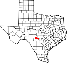 | |
| Unincorporated communities | ||
