Crane, Texas
| Crane, Texas | |
|---|---|
| City | |
|
| |
 Location of Crane, Texas | |
| Coordinates: 31°23′35″N 102°21′3″W / 31.39306°N 102.35083°WCoordinates: 31°23′35″N 102°21′3″W / 31.39306°N 102.35083°W | |
| Country | United States |
| State | Texas |
| County | Crane |
| Area | |
| • Total | 1.0 sq mi (2.7 km2) |
| • Land | 1.0 sq mi (2.7 km2) |
| • Water | 0.0 sq mi (0.0 km2) |
| Elevation | 2,575 ft (785 m) |
| Population (2010) | |
| • Total | 3,353 |
| • Density | 3,242/sq mi (1,251.8/km2) |
| Time zone | Central (CST) (UTC-6) |
| • Summer (DST) | CDT (UTC-5) |
| ZIP code | 79731 |
| Area code(s) | 432 |
| FIPS code | 48-17516[1] |
| GNIS feature ID | 1355307[2] |
| Website |
cityofcranetexas |
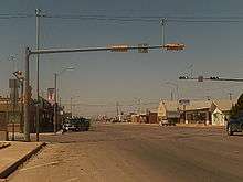
Crane is a city in and the county seat of Crane County, Texas, United States.[3] The population was 3,353 at the 2010 census.[4] An oil boomtown since the 1920s, Crane is still in the center of a prominent oil-producing region. It is the only significant town in sparsely populated Crane County and contains the only post office in the county.
History
While the post office dates from 1908, it was the discovery of oil in 1926 in the Permian Basin that brought in enough fortune-seekers to populate a town. Streets are named for the children of O.C. Kinnison, the realtor who drew up the town map. As in other oil boomtowns, development of services lagged behind temporary dwellings for the workers, although paved roads and other basic infrastructure was added as the town grew. Peak population as reported by the U.S. Census was in 1960 at 3,796, and it has declined slightly since, although the town remains the center for servicing the oil fields in Crane County.[5]
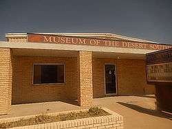
The Museum of the Desert Southwest is the area's museum of local history and is operated by the Crane County Historical Commission.[6]
Geography
Crane is located in eastern Crane County at 31°23′35″N 102°21′3″W / 31.39306°N 102.35083°W (31.392949, -102.350751).[7] According to the United States Census Bureau, the city has a total area of 1.0 square mile (2.7 km2), all of it land.[4]
The main highway through Crane is U.S. Route 385, which leads north 32 miles (51 km) to Odessa and south 21 miles (34 km) to McCamey.
| Climate data for Crane, Texas | |||||||||||||
|---|---|---|---|---|---|---|---|---|---|---|---|---|---|
| Month | Jan | Feb | Mar | Apr | May | Jun | Jul | Aug | Sep | Oct | Nov | Dec | Year |
| Average high °F (°C) | 61 (16) |
67 (19) |
75 (24) |
84 (29) |
91 (33) |
95 (35) |
97 (36) |
95 (35) |
89 (32) |
81 (27) |
71 (22) |
63 (17) |
80.8 (27.1) |
| Average low °F (°C) | 31 (−1) |
36 (2) |
43 (6) |
52 (11) |
60 (16) |
68 (20) |
71 (22) |
69 (21) |
64 (18) |
53 (12) |
42 (6) |
34 (1) |
51.9 (11.2) |
| Average precipitation inches (mm) | 0.4 (10) |
0.6 (15) |
0.4 (10) |
0.9 (23) |
1.7 (43) |
1.7 (43) |
1.5 (38) |
1.9 (48) |
3 (80) |
1.6 (41) |
0.7 (18) |
0.5 (13) |
14.8 (376) |
| Source: [8] | |||||||||||||
Demographics
| Historical population | |||
|---|---|---|---|
| Census | Pop. | %± | |
| 1940 | 1,420 | — | |
| 1950 | 2,154 | 51.7% | |
| 1960 | 3,796 | 76.2% | |
| 1970 | 3,427 | −9.7% | |
| 1980 | 3,622 | 5.7% | |
| 1990 | 3,533 | −2.5% | |
| 2000 | 3,191 | −9.7% | |
| 2010 | 3,353 | 5.1% | |
| Est. 2015 | 3,895 | [9] | 16.2% |

As of the census[1] of 2000, there were 3,191 people, 1,096 households, and 865 families residing in the city. The population density was 3,129.7 people per square mile (1,207.9/km²). There were 1,278 housing units at an average density of 1,253.5 per square mile (483.8/km²). The racial makeup of the city was 28.11% White, 3.01% African American, 0.97% Native American, 0.38% Asian, 19.43% from other races, and 2.70% from two or more races. Hispanic or Latino were 45.41% of the population.
There were 1,096 households out of which 43.8% had children under the age of 18 living with them, 66.0% were married couples living together, 8.9% had a female householder with no husband present, and 21.0% were non-families. 19.3% of all households were made up of individuals and 10.4% had someone living alone who was 65 years of age or older. The average household size was 2.90 and the average family size was 3.35.
In the city the population was spread out with 32.6% under the age of 18, 7.8% from 18 to 24, 27.4% from 25 to 44, 21.5% from 45 to 64, and 10.7% who were 65 years of age or older. The median age was 33 years. For every 100 females there were 93.3 males. For every 100 females age 18 and over, there were 89.3 males.
The median income for a household in the city was $31,774, and the median income for a family was $36,386. Males had a median income of $32,250 versus $18,086 for females. The per capita income for the city was $12,776. About 13.0% of families and 13.1% of the population were below the poverty line, including 15.1% of those under age 18 and 8.0% of those age 65 or over.
Education
The city is served by the Crane Independent School District and is home to the Crane High School Golden Cranes.
Notable people
- Ernest Angelo, oilman, former mayor of Midland, and Republican politician; resided in Crane in the middle 1950s
- Kip Averitt, Republican former state senator
- Elmer Kelton, western novelist
- Paul Patterson, western author and educator at Crane High School; mentor of Elmer Kelton
- Gary Watkins, politician from Odessa, born in Crane in 1946
- Clayton W. Williams, Sr., rancher, oilman, and historian
References
- 1 2 "American FactFinder". United States Census Bureau. Archived from the original on September 11, 2013. Retrieved 2008-01-31.
- ↑ "US Board on Geographic Names". United States Geological Survey. 2007-10-25. Retrieved 2008-01-31.
- ↑ "Find a County". National Association of Counties. Archived from the original on May 31, 2011. Retrieved 2011-06-07.
- 1 2 "Geographic Identifiers: 2010 Census Summary File 1 (G001): Crane city, Texas". U.S. Census Bureau, American Factfinder. Retrieved August 6, 2015.
- ↑ "Crane, Texas". Handbook of Texas Online. Retrieved 2009-12-23.
- ↑ "Official site". Crane County Historical Commission. Retrieved 14 October 2014.
- ↑ "US Gazetteer files: 2010, 2000, and 1990". United States Census Bureau. 2011-02-12. Retrieved 2011-04-23.
- ↑ weatherbase.com
- ↑ "Annual Estimates of the Resident Population for Incorporated Places: April 1, 2010 to July 1, 2015". Retrieved July 2, 2016.
- ↑ "Census of Population and Housing". Census.gov. Archived from the original on May 11, 2015. Retrieved June 4, 2015.
External links
Municipalities and communities of Crane County, Texas, United States | ||
|---|---|---|
| City | 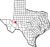 | |
| Unincorporated community | ||
