List of the major 4000-meter summits of Alaska
The following sortable table comprises the 23 mountain peaks of the U.S. State of Alaska with at least 4000 meters (13,123 feet) of topographic elevation and at least 500 meters (1640 feet) of topographic prominence.
Topographic elevation is the vertical distance above the reference geoid, a mathematical model of the Earth's sea level as an equipotential gravitational surface. The topographic prominence of a summit is the elevation difference between that summit and the highest or key col to a higher summit. The topographic isolation of a summit is the minimum great-circle distance to a point of equal elevation.
This article defines a significant summit as a summit with at least 100 meters (328.1 feet) of topographic prominence, and a major summit as a summit with at least 500 meters (1640 feet) of topographic prominence. An ultra-prominent summit is a summit with at least 1500 meters (4921 feet) of topographic prominence. There are 65 ultra-prominent summits in Alaska.
If an elevation or prominence is calculated as a range of values, the arithmetic mean is shown.
Major 4000-meter summits
Of the 104 major 4000-meter summits of the United States, the following 23 rise in Alaska. Five of these peaks lie on the international border with Yukon and one lies on the international border with British Columbia.
Gallery
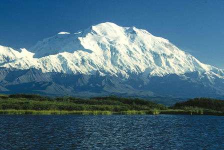
- Denali is the highest mountain peak of the State of Alaska, the United States of America, and all of North America.
 Mount Saint Elias on the boundary between Alaska and the Yukon is the second highest peak of both the United States and Canada.
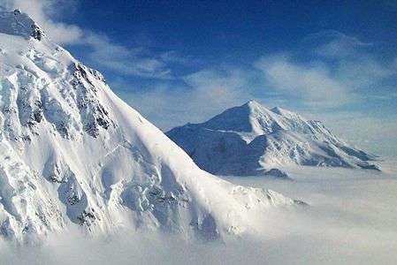
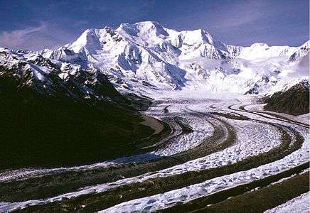 Mount Blackburn is the highest peak of the Wrangell Mountains.
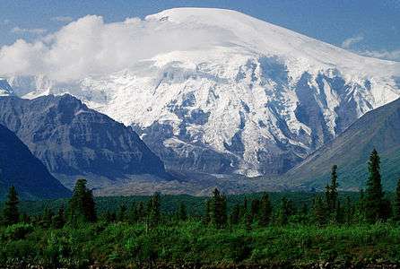 Mount Sanford is the second highest peak of the Wrangell Mountains.
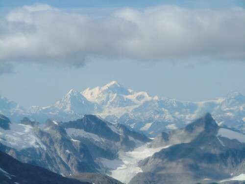 Mount Fairweather on the boundary between Alaska and British Columbia is the second most topographically prominent mountain peak of Alaska.
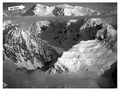 Mount Bear in the Saint Elias Mountains.
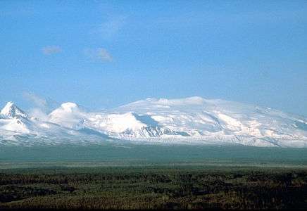
See also
- List of mountain peaks of North America
- List of mountain peaks of Greenland
- List of mountain peaks of Canada
- List of mountain peaks of the Rocky Mountains
- List of mountain peaks of the United States
- List of mountain peaks of Alaska
- List of the major 4000-meter summits of Alaska
- List of the ultra-prominent summits of Alaska
- List of mountain peaks of California
- List of mountain peaks of Colorado
- List of mountain peaks of Hawaiʻi
- List of mountain peaks of Alaska
- List of mountain peaks of México
- List of mountain peaks of Central America
- List of mountain peaks of the Caribbean
- Alaska
- Geography of Alaska
- Category:Mountains of Alaska
- Geography of Alaska
- Physical geography
References
- ↑ The summit of Denali is the highest point of the Alaska Range, the State of Alaska, the United States of America, and all of North America. Denali is the third most topographically prominent and third most topographically isolated summit on Earth after Mount Everest and Aconcagua.
- ↑ "Denali". Peakbagger.com. Retrieved March 3, 2016.
- ↑ "Denali". Bivouac.com. Retrieved March 3, 2016.
- ↑ Mount Saint Elias is the second highest major summit of both Canada and the United States.
- ↑ "Mount Saint Elias". Peakbagger.com. Retrieved March 3, 2016.
- ↑ "Mount Saint Elias". Bivouac.com. Retrieved March 3, 2016.
- ↑ "Mount Foraker". Peakbagger.com. Retrieved March 3, 2016.
- ↑ "Mount Foraker". Bivouac.com. Retrieved March 3, 2016.
- ↑ The summit of Mount Bona is the highest point of the northwest Saint Elias Mountains.
- ↑ "Mount Bona". Peakbagger.com. Retrieved March 3, 2016.
- ↑ "Mount Bona". Bivouac.com. Retrieved March 3, 2016.
- ↑ The summit of Mount Blackburn is the highest point of the Wrangell Mountains.
- ↑ "MT BLACKBURN". Datasheet for NGS Station UV4136. United States National Geodetic Survey. Retrieved March 3, 2016.
- ↑ "Mount Blackburn". Peakbagger.com. Retrieved March 3, 2016.
- ↑ "Mount Blackburn". Bivouac.com. Retrieved March 3, 2016.
- ↑ "Mount Sanford". Peakbagger.com. Retrieved March 3, 2016.
- ↑ "Mount Sanford". Bivouac.com. Retrieved March 3, 2016.
- ↑ Mount Fairweather on the international border of Alaska is the highest point the Canadian Province of British Columbia.
- ↑ "Mount Fairweather". Peakbagger.com. Retrieved March 3, 2016.
- ↑ "Mount Fairweather". Bivouac.com. Retrieved March 3, 2016.
- ↑ "Mount Hubbard". Peakbagger.com. Retrieved March 3, 2016.
- ↑ "Mount Hubbard". Bivouac.com. Retrieved March 3, 2016.
- ↑ "Mount Bear". Peakbagger.com. Retrieved March 3, 2016.
- ↑ "Mount Bear". Bivouac.com. Retrieved March 3, 2016.
- ↑ "Mount Hunter". Peakbagger.com. Retrieved March 3, 2016.
- ↑ "Mount Hunter". Bivouac.com. Retrieved March 3, 2016.
- ↑ "BOUNDARY POINT 180". Datasheet for NGS Station UV3032. United States National Geodetic Survey. Retrieved March 3, 2016.
- ↑ "Mount Alverstone". Peakbagger.com. Retrieved March 3, 2016.
- ↑ "Mount Alverstone". Bivouac.com. Retrieved March 3, 2016.
- ↑ "University Peak". Peakbagger.com. Retrieved March 3, 2016.
- ↑ "University Peak". Bivouac.com. Retrieved March 3, 2016.
- ↑ "Mount Wrangell". Peakbagger.com. Retrieved March 3, 2016.
- ↑ "Mount Wrangell". Bivouac.com. Retrieved March 3, 2016.
- ↑ "Mount Augusta". Peakbagger.com. Retrieved March 3, 2016.
- ↑ "Mount Augusta". Bivouac.com. Retrieved March 3, 2016.
- ↑ "Atna Peaks". Peakbagger.com. Retrieved March 3, 2016.
- ↑ "Atna Peaks". Bivouac.com. Retrieved March 3, 2016.
- ↑ "REGAL MOUNTAIN". Datasheet for NGS Station UV4133. United States National Geodetic Survey. Retrieved March 3, 2016.
- ↑ "Regal Mountain". Peakbagger.com. Retrieved March 3, 2016.
- ↑ "Regal Mountain". Bivouac.com. Retrieved March 3, 2016.
- ↑ The summit of Mount Hayes is the highest point of the Hayes Range.
- ↑ "Mount Hayes". Peakbagger.com. Retrieved March 3, 2016.
- ↑ "Mount Hayes". Bivouac.com. Retrieved March 3, 2016.
- ↑ "Mount Cook". Peakbagger.com. Retrieved March 3, 2016.
- ↑ "Mount Cook". Bivouac.com. Retrieved March 3, 2016.
- ↑ "Mount Natazhat". Peakbagger.com. Retrieved March 3, 2016.
- ↑ "Mount Natazhat". Bivouac.com. Retrieved March 3, 2016.
- ↑ "Mount Jarvis". Peakbagger.com. Retrieved March 3, 2016.
- ↑ "Mount Jarvis". Bivouac.com. Retrieved March 3, 2016.
- ↑ "Tressider Peak". Peakbagger.com. Retrieved March 3, 2016.
- ↑ "Tressider Peak". Bivouac.com. Retrieved March 3, 2016.
- ↑ "Mount Silverthrone". Peakbagger.com. Retrieved March 3, 2016.
- ↑ "Mount Silverthrone". Bivouac.com. Retrieved March 3, 2016.
- ↑ The summit of Mount Marcus Baker is the highest point of the Chugach Mountains.
- ↑ "Mount Marcus Baker". Peakbagger.com. Retrieved March 3, 2016.
- ↑ "Mount Marcus Baker". Bivouac.com. Retrieved March 3, 2016.
External links
- United States Geological Survey (USGS)
- United States National Geodetic Survey (NGS)
- United States National Park Service (NPS)
- Bivouac.com
- Peakbagger.com
- Peaklist.org
- Peakware.com
- Summitpost.org
Juneau (capital) | ||
| Topics |
|  |
| Society |
| |
| Regions | ||
| Largest cities | ||
| Boroughs | ||
| Census Areas | ||
Coordinates: 63°04′08″N 151°00′23″W / 63.0690°N 151.0063°W