Greater Manchester
| Greater Manchester | |||
|---|---|---|---|
| County | |||
| |||
 Greater Manchester in England | |||
| Coordinates: 53°30′N 2°19′W / 53.500°N 2.317°WCoordinates: 53°30′N 2°19′W / 53.500°N 2.317°W | |||
| Sovereign state | United Kingdom | ||
| Country | England | ||
| Region | North West | ||
| Established | 1 April 1974 | ||
| Established by | Local Government Act 1972 | ||
| Ceremonial county | |||
| Lord Lieutenant | Warren James Smith | ||
| High Sheriff | Lady Joy Smith | ||
| Area | 1,276 km2 (493 sq mi) | ||
| • Ranked | 39th of 48 | ||
| Population (mid-2014 est.) | 2,732,854 | ||
| • Ranked | 3rd of 48 | ||
| Density | 2,105/km2 (5,450/sq mi) | ||
| Ethnicity |
| ||
| Metropolitan county | |||
| Government | Greater Manchester Combined Authority | ||
| ONS code | 2A | ||
| GSS code | E11000001 | ||
| NUTS | UKD3 | ||
| Website |
www | ||
 Districts of Greater Manchester Metropolitan districts | |||
| Districts | |||
| Members of Parliament | List of MPs | ||
| Police | Greater Manchester Police | ||
| Time zone | GMT (UTC) | ||
| • Summer (DST) | BST (UTC+1) | ||
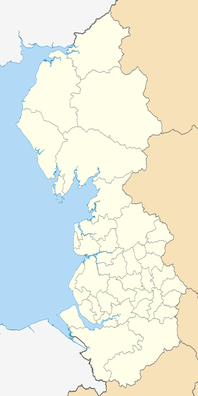
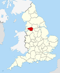
Greater Manchester is a metropolitan county in North West England, with a population of 2.8 million.[1] It encompasses one of the largest metropolitan areas in the United Kingdom and comprises ten metropolitan boroughs: Bolton, Bury, Oldham, Rochdale, Stockport, Tameside, Trafford, Wigan, and the cities of Manchester and Salford. Greater Manchester was created on 1 April 1974 as a result of the Local Government Act 1972; and designated a City Region on 1 April 2011.
Greater Manchester spans 493 square miles (1,277 km2),[2] which roughly covers the territory of the Greater Manchester Built-up Area, the second most populous urban area in the UK. It is landlocked and borders Cheshire (to the south-west and south), Derbyshire (to the south-east), West Yorkshire (to the north-east), Lancashire (to the north) and Merseyside (to the west). There is a mix of high-density urban areas, suburbs, semi-rural and rural locations in Greater Manchester, but land use is mostly urban — the product of concentric urbanisation and industrialisation which occurred mostly during the 19th century when the region flourished as the global centre of the cotton industry. It has a focused central business district, formed by Manchester city centre and the adjoining parts of Salford and Trafford, but Greater Manchester is also a polycentric county with ten metropolitan districts, each of which has at least one major town centre and outlying suburbs.
For the 12 years following 1974 the county had a two-tier system of local government; district councils shared power with the Greater Manchester County Council. The county council was abolished in 1986, and so its districts (the metropolitan boroughs) effectively became unitary authority areas. However, the metropolitan county has continued to exist in law and as a geographic frame of reference,[3] and as a ceremonial county, has a Lord Lieutenant and a High Sheriff. Several county-wide services were co-ordinated through the Association of Greater Manchester Authorities until April 2011, when the Greater Manchester Combined Authority was established as the strategic county-wide authority for Greater Manchester, taking on functions and responsibilities for economic development, regeneration and transport. A further devolution of powers to Greater Manchester is set to take place upon the election of the inaugural Mayor of Greater Manchester scheduled for 2017.
Before the creation of the metropolitan county, the name SELNEC was used for the area, taken from the initials of "South East Lancashire North East Cheshire". Greater Manchester is an amalgamation of 70 former local government districts from the former administrative counties of Lancashire, Cheshire, the West Riding of Yorkshire and eight independent county boroughs.[4] Since deindustrialisation in the mid-20th century, Greater Manchester has emerged as an exporter of media and digital content, guitar and dance music, and association football.[5]
History
Origins
Although the modern county of Greater Manchester was not created until 1974, the history of its constituent settlements and parts goes back centuries. There is evidence of Iron Age habitation, particularly at Mellor,[6] and Celtic activity in a settlement named Chochion, believed to have been an area of Wigan settled by the Brigantes.[7] Stretford was also part of the land believed to have been occupied by the Celtic Brigantes tribe, and lay on their border with the Cornovii on the southern side of the River Mersey.[8] The remains of 1st-century forts at Castlefield in Manchester,[9] and Castleshaw Roman fort in Saddleworth,[10] are evidence of Roman occupation. Much of the region was omitted from the Domesday Book of 1086; Redhead states that this was because only a partial survey was taken, rather than sparsity of population.[11]
During the Middle Ages, much of what became Greater Manchester lay within the hundred of Salfordshire – an ancient division of the county of Lancashire. Salfordshire encompassed several parishes and townships, some of which, like Rochdale, were important market towns and centres of England's woollen trade. The development of what became Greater Manchester is attributed to a shared tradition of domestic flannel and fustian cloth production, which encouraged a system of cross-regional trade.[12][13][14] In the late-18th century, the Industrial Revolution transformed the local domestic system; mechanisation enabled the industrialisation of the region's textile trade, triggering rapid growth in the cotton industry and expansion in ancillary trades.[15] Infrastructure such as rows of terraced housing, factories and roads were constructed to house labour, transport goods, and produce cotton goods on an industrial scale for a global market.[15][14] The townships in and around Manchester began expanding "at an astonishing rate" around the turn of the 19th century as part of a process of unplanned urbanisation brought on by a boom in industrial textile production and processing.[16] This population increase resulted in the "vigourous concentric growth" of a conurbation between Manchester and an arc of surrounding mill towns, formed from a steady acretion of houses, factories and transport infrastructure.[17] Places such as Bury, Oldham and Bolton played a central economic role nationally, and by the end of the 19th century had become some of the most important and productive cotton-producing towns in the world.[18] However, it was Manchester that was the most populous settlement, a major city, the world's largest marketplace for cotton goods,[19][20] and the natural centre of its region.[21] By 1835 "Manchester was without challenge the first and greatest industrial city in the world";[20] and by 1848 urban sprawl had fused the city to its surrounding towns and hinterland to form a single continuous conurbation.[17] In the 1910s, local government reforms to administer this conurbation as a single entity were proposed.[22]
In the 18th century, German traders had coined the name Manchesterthum to cover the region in and around Manchester.[23] However, the English term "Greater Manchester" did not appear until the 20th century. One of its first known recorded uses was in a 1914 report put forward in response to what was considered to have been the successful creation of the County of London in 1889.[22] The report suggested that a county should be set up to recognise the "Manchester known in commerce", and referred to the areas that formed "a substantial part of South Lancashire and part of Cheshire, comprising all municipal boroughs and minor authorities within a radius of eight or nine miles of Manchester".[22][24] In his 1915 book Cities In Evolution, urban planner Sir Patrick Geddes wrote "far more than Lancashire realises, is growing up another Greater London".[25]
.png)
Most of Greater Manchester lay within the ancient county boundaries of Lancashire; those areas south of the Mersey and Tame were in Cheshire. The Saddleworth area and a small part of Mossley are historically part of Yorkshire and in the south-east a small part in Derbyshire. The areas that were incorporated into Greater Manchester in 1974 previously formed parts of the administrative counties of Cheshire, Lancashire, the West Riding of Yorkshire and of eight independent county boroughs.[4] By the early 1970s, this system of demarcation was described as "archaic" and "grossly inadequate to keep pace both with the impact of motor travel, and with the huge increases in local government responsibilities".[26]
The Manchester Evening Chronicle brought to the fore the issue of "regional unity" for the area in April 1935 under the headline "Greater Manchester – The Ratepayers' Salvation". It reported on the "increasing demands for the exploration of the possibilities of a greater merger of public services throughout Manchester and the surrounding municipalities".[27] The issue was frequently discussed by civic leaders in the area at that time, particularly those from Manchester and Salford. The Mayor of Salford pledged his support to the idea, stating that he looked forward to the day when "there would be a merging of the essential services of Manchester, Salford, and the surrounding districts constituting Greater Manchester."[27] Proposals were halted by the Second World War, though in the decade after it, the pace of proposals for local government reform for the area quickened.[28] In 1947, Lancashire County Council proposed a three "ridings" system to meet the changing needs of the county of Lancashire, including those for Manchester and surrounding districts.[28] Other proposals included the creation of a Manchester County Council, a directly elected regional body. In 1951, the census in the UK began reporting on South East Lancashire as a homogeneous conurbation.[28]
Redcliffe-Maud Report
The Local Government Act 1958 designated the south east Lancashire area (which, despite its name, included part of north east Cheshire), a Special Review Area. The Local Government Commission for England presented draft recommendations, in December 1965, proposing a new county based on the conurbation surrounding and including Manchester, with nine most-purpose boroughs corresponding to the modern Greater Manchester boroughs (excluding Wigan). The review was abolished in favour of the Royal Commission on Local Government before issuing a final report.[29]
The Royal Commission's 1969 report, known as the Redcliffe-Maud Report, proposed the removal of much of the then existing system of local government. The commission described the system of administering urban and rural districts separately as outdated, noting that urban areas provided employment and services for rural dwellers, and open countryside was used by town dwellers for recreation. The commission considered interdependence of areas at many levels, including travel-to-work, provision of services, and which local newspapers were read, before proposing a new administrative metropolitan area.[30] The area had roughly the same northern boundary as today's Greater Manchester (though included Rossendale), but covered much more territory from Cheshire (including Macclesfield, Warrington, Alderley Edge, Northwich, Middlewich, Wilmslow and Lymm), and Derbyshire (the towns of New Mills, Whaley Bridge, Glossop and Chapel-en-le-Frith – a minority report suggested that Buxton be included).[31] The metropolitan area was to be divided into nine metropolitan districts, based on Wigan, Bolton, Bury/Rochdale, Warrington, Manchester (including Salford and Old Trafford), Oldham, Altrincham, Stockport and Tameside.[31] The report noted "The choice even of a label of convenience for this metropolitan area is difficult".[32] Seven years earlier, a survey prepared for the British Association intended to define the "South-East Lancashire conurbation" noted that "Greater Manchester it is not ... One of its main characteristics is the marked individuality of its towns, ... all of which have an industrial and commercial history of more than local significance".[33] The term Selnec (or SELNEC) was already in use as an abbreviation for south east Lancashire and north east Cheshire; Redcliffe-Maud took this as "the most convenient term available", having modified it to south east Lancashire, north east and central Cheshire.[31]
Following the Transport Act 1968, in 1969 the SELNEC Passenger Transport Executive (an authority to co-ordinate and operate public transport in the region) was set up, covering an area smaller than the proposed Selnec, and different again to the eventual Greater Manchester. Compared with the Redcliffe-Maud area, it excluded Macclesfield, Warrington, and Knutsford but included Glossop and Saddleworth in the West Riding of Yorkshire. It excluded Wigan, which was in both the Redcliffe-Maud area and in the eventual Greater Manchester (but had not been part of the 1958 act's review area).[34]
Redcliffe-Maud's recommendations were accepted by the Labour-controlled government in February 1970.[35] Although the Redcliffe-Maud Report was rejected by the Conservative government after the 1970 general election, there was a commitment to local government reform, and the need for a metropolitan county centred on the conurbation surrounding Manchester was accepted. The new government's original proposal was much smaller than the Redcliffe-Maud Report's Selnec, with areas such as Winsford, Northwich, Knutsford, Macclesfield and Glossop retained by their original counties to ensure their county councils had enough revenue to remain competitive (Cheshire County Council would have ceased to exist).[35] Other late changes included the separation of the proposed Bury/Rochdale authority (retained from the Redcliffe-Maud report) into the Metropolitan Borough of Bury and the Metropolitan Borough of Rochdale. Bury and Rochdale were originally planned to form a single district (dubbed "Botchdale" by local MP Michael Fidler)[36][37] but were divided into separate boroughs. To re-balance the districts, the borough of Rochdale took Middleton from Oldham.[38] During the passage of the bill, the towns of Whitworth, Wilmslow and Poynton successfully objected to their incorporation in the new county.[35]
.png)
1974–1997

.jpg)

The Local Government Act 1972 reformed local government in England by creating a system of two-tier metropolitan and non-metropolitan counties and districts throughout the country.[39] The act formally established Greater Manchester on 1April 1974,[41] although Greater Manchester County Council (GMCC) had been running since elections in 1973.[42] The leading article in The Times on the day the Local Government Act came into effect noted that the "new arrangement is a compromise which seeks to reconcile familiar geography which commands a certain amount of affection and loyalty, with the scale of operations on which modern planning methods can work effectively".[43] Frangopulo noted that the creation of Greater Manchester "was the official unifying of a region which, through history and tradition, had forged for itself over many centuries bonds ... between the communities of town and village, each of which was the embodiment of the character of this region".[44] The name Greater Manchester was adopted, having been favoured over Selnec by the local population.[45]
By January 1974, a joint working party representing Greater Manchester had drawn up its county Structure Plan, ready for implementation by the Greater Manchester County Council. The plan set out objectives for the forthcoming metropolitan county.[46] The highest priority was to increase the quality of life for its inhabitants by improving the county's physical environment and cultural facilities which had suffered following deindustrialisation—much of Greater Manchester's basic infrastructure dated from its 19th-century growth, and was unsuited to modern lifestyles.[47] Other objectives were to reverse the trend of depopulation in central-Greater Manchester, to invest in country parks to improve the region's poor reputation on leisure facilities, and to improve the county's transport infrastructure and patterns.[48]
Because of political objection, particularly from Cheshire, Greater Manchester covered only the inner, urban 62 of the 90 former districts that the Royal Commission had outlined as an effective administrative metropolitan area.[49] In this capacity, GMCC found itself "planning for an arbitrary metropolitan area ... abruptly truncated to the south", and so had to negotiate several land-use, transport and housing projects with its neighbouring county councils.[49] However a "major programme of environmental action" by GMCC broadly succeeded in reversing social deprevation in its inner city slums.[49] Leisure and recreational successes included the Greater Manchester Exhibition Centre (better known as the G-Mex centre and now branded Manchester Central), a converted former railway station in Manchester city centre used for cultural events,[50] and GMCC's creation of five new country parks within its boundaries.[51] GMCC was, however, criticised for being too Manchester-centric by representatives from the outer suburbs.[52]
Unlike most other modern counties (including Merseyside and Tyne and Wear), Greater Manchester was never adopted as a postal county by the Royal Mail. A review in 1973 noted that "Greater Manchester" would be unlikely to be adopted because of confusion with the Manchester post town.[53] The component areas of Greater Manchester held on to their pre-1974 postal counties until 1996, when they were abolished.[54]
A decade after they were established, the mostly Labour-controlled metropolitan county councils and the Greater London Council (GLC) had several high-profile clashes with the Conservative government of Margaret Thatcher, with regards overspending and high rates charging. Government policy on the issue was considered throughout 1982, and the Conservative Party put a "promise to scrap the metropolitan county councils" and the GLC, in their manifesto for the 1983 general election.[55][56] Greater Manchester County Council was abolished on 31 March 1986 under the Local Government Act 1985. That the metropolitan county councils were controlled by the Labour Party led to accusations that their abolition was motivated by party politics:[55] the general secretary of the National Association of Local Government Officers described it as a "completely cynical manoeuvre".[57] Most of the functions of GMCC were devolved to the ten Greater Manchester metropolitan district councils, though functions such as emergency services and public transport were taken over by joint boards and continued to be run on a county-wide basis.[58] The Association of Greater Manchester Authorities (AGMA) was established to continue much of the county-wide services of the county council.[59] The metropolitan county continues to exist in law, and as a geographic frame of reference,[3] for example as a NUTS 2 administrative division for statistical purposes within the European Union.[60] Although having been a Lieutenancy area since 1974, Greater Manchester was included as a ceremonial county by the Lieutenancies Act 1997 on 1 July 1997.[61]
Combined Authority
In 1998, the people of Greater London voted in a referendum in favour of establishing a new Greater London Authority, with mayor and an elected chamber for the county.[62] The New Local Government Network proposed the creation of a new Manchester City Region based on Greater Manchester and other metropolitan counties as part of on-going reform efforts, while a report released by the Institute for Public Policy Research's Centre for Cities proposed the creation of two administrative city regions based on Manchester and Birmingham. In July 2007, The Treasury published its Review of sub-national economic development and regeneration, which stated that the government would allow those city regions that wished to work together to form a statutory framework for city regional activity, including powers over transport, skills, planning and economic development.[63] In January 2008, AGMA suggested that a formal government structure be created to cover Greater Manchester.[64] The issue resurfaced in June 2008 with regards to proposed congestion charging in Greater Manchester; Sir Richard Leese (leader of Manchester City Council) said "I've come to the conclusion that [a referendum on congestion charging should be held] because we don't have an indirectly or directly elected body for Greater Manchester that has the power to make this decision".[65] On 14 July 2008 the ten local authorities in Greater Manchester agreed to a strategic and integrated cross-county Multi-Area Agreement; a voluntary initiative aimed at making district councils "work together to challenge the artificial limits of boundaries" in return for greater autonomy from the central government of the UK.[66] A referendum on the Greater Manchester Transport Innovation Fund was held in December 2008,[67] in which voters "overwhelmingly rejected" plans for public transport improvements linked to a peak-time weekday-only congestion charge.[68]
Following a bid from AGMA highlighting the potential benefits in combatting the late-2000s financial crisis, it was announced in the 2009 United Kingdom Budget that Greater Manchester and the Leeds City Region would be awarded Statutory City Region Pilot status, allowing (if they desired) for their constituent district councils to pool resources and become statutory Combined Authorities with powers comparable to the Greater London Authority.[69] The stated aim of the pilot was to evaluate the contributions to economic growth and sustainable development by Combined Authorities.[70] The Local Democracy, Economic Development and Construction Act 2009 enabled the creation of a Combined Authority for Greater Manchester with devolved powers on public transport, skills, housing, regeneration, waste management, carbon neutrality and planning permission, pending approval from the ten councils.[69][71] Such strategic matters would be decided on via an enhanced majority rule voting system involving ten members appointed from among the councillors of the metropolitan boroughs (one representing each borough with each council nominating one substitute) without the input of central government. The ten district councils of Greater Manchester approved the creation of the Greater Manchester Combined Authority (GMCA) on 29 March 2010, and submitted final recommendations for a constitution to the Department for Communities and Local Government and the Department for Transport. On 31 March 2010 the Communities Secretary John Denham approved the constitution and launched a 15-week public consultation on the draft bill together with the approved constitution.[72] Following requests by the Association of Greater Manchester Authorities, which was superseded by the GMCA,[73][74][75] the new authority came into being on 1 April 2011.[76] On the same day, the Transport for Greater Manchester Committee was also formed from a pool of 33 councillors allocated by council population (roughly one councillor per 75,000 residents) to scrutinise the running of Greater Manchester's transport bodies and their finances, approve the decisions and policies of said bodies and form strategic policy recommendations or projects for the approval of the Combined Authority.[69] On 3 November 2014, George Osborne, the Chancellor of the Exchequer, announced that there would be an eleventh member of the GMCA — a directly elected Mayor of Greater Manchester, with "powers over transport, housing, planning and policing" from 2017.[77] This announcement was followed up on 25 February 2015 with news that Greater Manchester would be the first part of England to "get full control of its health spending" with a devolution deal from April 2016.[78]
Geography


Greater Manchester is a landlocked county spanning 493 square miles (1,277 km2).[2] The South Pennines rise along the northeastern side of the county, through parts of Oldham, Rochdale and Tameside. The West Pennine Moors and several coalfields (mainly sandstones and shales) lie in the northwest and west respectively, and the Cheshire Plain fringes the south.[15] The rivers Mersey, Irwell and Tame run through Greater Manchester, all of which rise in the Pennines.[15] Other rivers traverse the region as tributaries to the major rivers, including the Douglas, the Irk, and the Roch.[15] Black Chew Head is the highest point in Greater Manchester which forms part of the Peak District National Park, rising 1,778 feet (542 m) above sea-level, within the parish of Saddleworth.[79]
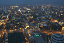
Greater Manchester is characterised by dense urban and industrial development, which includes centres of commerce, finance, retail and administration, as well as commuter suburbs and housing, interspersed with transport infrastructure such as light rail, roads and motorway, and canals.[15] There is a mix of high density urban areas, suburbs, semi-rural and rural locations in Greater Manchester, but land use is mostly urban.[80] The built environment of Greater Manchester utilises red brick and sandstone prominently as a building material, alongside structures composed of modern materials, high-rise towers, and landmark 19th-, 20th- and 21st-century buildings in the city and town centres.[15] Manchester city centre is the commercial and geographic heart of Greater Manchester,[81][82][83] and with the adjoining parts of Salford and Trafford, is defined as Greater Manchester's "Regional Centre" for purposes of urban planning and public transport.[81][83][84][85][86] Political and economic ties between the city centre and neighbouring Salford and Trafford have strengthened with the shift from town and district centres to metropolitan-level centres in England,[87][84] and this area's high-rise landmark buildings provide a visual orientation point of reference as a central business district.[15] However, Greater Manchester is also a polycentric county with ten metropolitan districts,[80] each of which has a major town centre – and in some cases more than one – and many smaller settlements.[80] The major towns encircle Manchester city centre, and between them are smaller towns (such as Denton, Middleton and Failsworth) which are suburban to both the Regional Centre and the major town centres.[88] Combined, these factors make Greater Manchester the most complex "polycentric functional urban region" in the UK outside London.[80][52]
The Greater Manchester Built-up Area is the conurbation or continuous urban area based around Greater Manchester, as defined by the Office for National Statistics. In 2011, it had an estimated population of 2,553,379, making it the second most populous built-up area in the UK, and occupied an area of 630.3 square kilometres (243.4 sq mi) at the time of the 2011 census.[89] The European Union designate the conurbation as a single homogonous urban city region.[90] The Built-up Area includes most of Greater Manchester, omitting areas of countryside and small villages, as well as noncontiguous urban towns such as Wigan and Marple.[89] Outside the boundary of Greater Manchester it includes several adjacent areas of settlement and a few outliers connected to the urban sprawl by ribbon development, such as Wilmslow and Alderley Edge in Cheshire, Glossop and Hadfield in Derbyshire, and Whitworth in Lancashire.[89] This conurbation forms part of a megalopolis of 9.4 million across northern England.[91][92][93]

Climate
Greater Manchester experiences a temperate maritime climate, like most of the British Isles, with relatively cool summers and mild winters. The county's average annual rainfall is 806.6 millimetres (31.76 in)[94] compared to the UK average of 1,125.0 millimetres (44.29 in),[95] and its mean rain days are 140.4 mm (5.53 in) per annum,[94] compared to the UK average of 154.4 mm (6.08 in).[95] The mean temperature is slightly above average for the United Kingdom.[96] Greater Manchester also has a relatively high humidity level, which lent itself to the optimised and breakage-free textile manufacturing which took place around the county. Snowfall is not a common sight in the built up areas, due to the urban warming effect. However, the Pennine and Rossendale Forest hills around the eastern and northern edges of the county receive more snow, and roads leading out of the county can be closed due to heavy snowfall,[97] notably the A62 road via Standedge, the A57 (Snake Pass) towards Sheffield,[98] and the M62 over Saddleworth Moor. In the most southern point of Greater Manchester, Woodford's Met Office weather station recorded a temperature of −17.6 °C (0.3 °F) on 8 January 2010, during the Winter of 2009-2010 in the United Kingdom.[99]
| Climate data for Manchester Ringway, elevation: 69 m or 226 ft (1981-2010) extremes (1958-2004) | |||||||||||||
|---|---|---|---|---|---|---|---|---|---|---|---|---|---|
| Month | Jan | Feb | Mar | Apr | May | Jun | Jul | Aug | Sep | Oct | Nov | Dec | Year |
| Record high °C (°F) | 14.3 (57.7) |
16.5 (61.7) |
21.7 (71.1) |
25.1 (77.2) |
26.7 (80.1) |
31.3 (88.3) |
32.2 (90) |
33.7 (92.7) |
28.4 (83.1) |
25.6 (78.1) |
17.7 (63.9) |
15.1 (59.2) |
33.7 (92.7) |
| Average high °C (°F) | 7.3 (45.1) |
7.6 (45.7) |
10.0 (50) |
12.6 (54.7) |
16.1 (61) |
18.6 (65.5) |
20.6 (69.1) |
20.3 (68.5) |
17.6 (63.7) |
13.9 (57) |
10.0 (50) |
7.4 (45.3) |
13.5 (56.3) |
| Daily mean °C (°F) | 4.5 (40.1) |
4.6 (40.3) |
6.7 (44.1) |
8.8 (47.8) |
11.9 (53.4) |
14.6 (58.3) |
16.6 (61.9) |
16.4 (61.5) |
14.0 (57.2) |
10.7 (51.3) |
7.1 (44.8) |
4.6 (40.3) |
10.0 (50) |
| Average low °C (°F) | 1.7 (35.1) |
1.6 (34.9) |
3.3 (37.9) |
4.9 (40.8) |
7.7 (45.9) |
10.5 (50.9) |
12.6 (54.7) |
12.4 (54.3) |
10.3 (50.5) |
7.4 (45.3) |
4.2 (39.6) |
1.8 (35.2) |
6.6 (43.9) |
| Record low °C (°F) | −12.0 (10.4) |
−13.1 (8.4) |
−9.7 (14.5) |
−4.9 (23.2) |
−1.7 (28.9) |
0.8 (33.4) |
5.4 (41.7) |
3.6 (38.5) |
0.8 (33.4) |
−4.7 (23.5) |
−7.5 (18.5) |
−13.5 (7.7) |
−13.5 (7.7) |
| Average precipitation mm (inches) | 72.3 (2.846) |
51.4 (2.024) |
61.2 (2.409) |
54.0 (2.126) |
56.8 (2.236) |
66.1 (2.602) |
63.9 (2.516) |
77.0 (3.031) |
71.5 (2.815) |
92.5 (3.642) |
81.5 (3.209) |
80.7 (3.177) |
828.8 (32.63) |
| Average precipitation days (≥ 1.0 mm) | 13.1 | 9.7 | 12.3 | 11.2 | 10.4 | 11.1 | 10.9 | 12.0 | 11.1 | 13.6 | 14.1 | 13.5 | 142.9 |
| Average snowy days | 6 | 5 | 3 | 2 | 0 | 0 | 0 | 0 | 0 | 0 | 1 | 3 | 20 |
| Average relative humidity (%) | 87 | 86 | 85 | 85 | 85 | 87 | 88 | 89 | 89 | 89 | 88 | 87 | 88 |
| Mean monthly sunshine hours | 52.5 | 73.9 | 99.0 | 146.9 | 188.3 | 172.5 | 179.7 | 166.3 | 131.2 | 99.3 | 59.5 | 47.1 | 1,416.2 |
| Source #1: Met Office[100] NOAA (relative humidity and snow days 1961-1990)[101] | |||||||||||||
| Source #2: KNMI[102] | |||||||||||||
Flora and fauna

Contrary to its reputation for urban sprawl,[103][104] Greater Manchester has a green belt, constraining urban drift, and a "wide and varied range" of wildlife and natural habitats.[103] For instance, the wooded valleys of Bolton, Bury and Stockport, the moorlands north and east of Rochdale, Oldham and Stalybridge, and the reed beds between Wigan and Leigh, harbour flora and fauna of national importance.[103] Mature woodland, scrubland, grassland, high moorland, mossland, agricultural land, lakes, wetlands, river valleys, embankments, urban parks and suburban gardens are habitats found in Greater Manchester which further contribute to biodiversity.[104] The Greater Manchester Ecology Unit classifies Sites of Biological Importance.[105]
The 21 Sites of Special Scientific Interest (SSSI) in Greater Manchester, and the 12.1 square miles (31 km2) of common land in Greater Manchester[106] are of particular interest to organisations such as the Greater Manchester Local Record Centre, the Greater Manchester Biodiversity Project and the Manchester Field Club, which are dedicated to wildlife conservation and the preservation of the region's natural history.[107][108][109] Among the SSSIs are Astley and Bedford Mosses which form a network of ancient peat bog on the fringe of Chat Moss,[103] which in turn, at 10.6 square miles (27 km2) comprises the largest area of prime farmland in Greater Manchester and contains the largest block of semi-natural woodland in the county.[110] The Wigan Flashes, such as those at Pennington Flash Country Park, are the by-product of coal mining, where subsidence has led to waterbodies collecting in the resulting hollows which form an important reed bed resource in Greater Manchester.[103] Opened in 1979, Sale Water Park is a 152-acre (62 ha) area of countryside and parkland in Sale which includes a 52-acre (21 ha) artificial lake by the River Mersey.[111]
Clover, sorrel, nettle and thistle are common, and grow wild in Greater Manchester.[104] Common heather (Calluna vulgaris) dominates the uplands, such as Saddleworth Moor, which lies within the South Pennines and Dark Peak area of the Peak District National Park.[112] The Rochdale Canal harbours floating water-plantain (Luronium), an endangered aquatic plant.[103] In 2002, Plantlife International launched its County Flowers campaign, asking members of the public to nominate and vote for a wild flower emblem for their county. Common cottongrass (Eriophorum angustifolium), a plant with fluffy white plumes native to wet hollows on high moors, was announced as the county flower of Greater Manchester.[113][114][115] The house sparrow, common starling, and common blackbird are among the most populous bird species in Greater Manchester; Eurasian magpie and feral pigeon are common and breed in habitats across the county.[116] The South Pennines support internationally important numbers of European golden plover, curlew, merlin and twite.[106]
Governance


The Greater Manchester Combined Authority (GMCA) is the top-tier administrative body for the local governance of Greater Manchester. It was established on 1 April 2011 as a pilot combined authority, unique to local government in the United Kingdom.[117] It consists of ten indirectly elected members, each a directly elected councillor from one of the ten metropolitan boroughs that comprise Greater Manchester. The authority derives most of its powers from the Local Government Act 2000 and Local Democracy, Economic Development and Construction Act 2009,[117] and replaced a range of single-purpose joint boards and quangos in 2011, to provide a formal administrative authority for Greater Manchester with powers over public transport, skills, housing, regeneration, waste management, carbon neutrality and planning permission.[117] Functional executive bodies, such as Transport for Greater Manchester, are responsible for delivery of services in these areas.[117] On 3 November 2014, the Devolution to the Greater Manchester Combined Authority agreement was signed to pass further powers and responsibilities, as well as the establishment of an elected Mayor of Greater Manchester with the first election to be held in 2017.[118] From April 2016, Greater Manchester will be the first part of England to "get full control of its health spending" with a devolution deal which aims to unite the region's health and social care systems under one budget under the control of local leaders, including Greater Manchester's new directly elected mayor.[78]
Beneath the GMCA are the ten councils of Greater Manchester's ten districts, which are Bolton, Bury, the City of Manchester, Oldham, Rochdale, the City of Salford, Stockport, Tameside, Trafford and Wigan. These district councils have the greatest powers over public services, and control matters such as council tax, education provision, social housing, libraries and healthcare. Eight of the ten metropolitan boroughs were named after the eight former county boroughs that now compose the largest centres of population and greater historical and political prominence.[119] As an example, the Metropolitan Borough of Stockport is centred on the town of Stockport, a former county borough, but includes other smaller settlements, such as Cheadle, Gatley, and Bramhall.[119] The names of two of the metropolitan boroughs were given a neutral name because, at the time they were created, there was no agreement on the town to be put forward as the administrative centre and neither had a county borough. These boroughs are Tameside and Trafford, centred on Ashton-under-Lyne and Stretford, respectively, and are named with reference to geographical and historical origins.[119] The lowest formal tier of local government in Greater Manchester are the parish councils, which cover the various civil parishes in Greater Manchester, and have limited powers over upkeep, maintenance and small grants.
For the first 12 years after the county was created in 1974, Greater Manchester had a two-tier system of local government, and the metropolitan borough councils shared power with the Greater Manchester County Council.[120] The Greater Manchester County Council, a strategic authority based in what is now Westminster House off Piccadilly Gardens, comprised 106 members drawn from the ten metropolitan boroughs of Greater Manchester.[121] It was a sub-regional body running regional services such as transport, strategic planning, emergency services and waste disposal. In 1986, along with the five other metropolitan county councils and the Greater London Council, the Greater Manchester County Council was abolished, and most of its powers were devolved to the boroughs.[120] Between 1986 and 2011, the boroughs were effectively unitary authority areas, but opted to co-operate voluntarily under the Association of Greater Manchester Authorities (AGMA), which served to create a co-ordinated county-wide approach to issues of common interest to Greater Manchester, such as public transport and the shared labour market, as well as making representations to central government and the European Union.
Although used as a "successful brand",[122] Greater Manchester's politics have been characterised by "entrenched localism and related rivalries", historically resistant to regionalism.[52] The major towns in Greater Manchester retain a "fierce independence",[21] meaning Greater Manchester is administered using "inter-municipal coordination" on a broadly voluntary basis.[52] That eight of the ten borough councils have (for the most part) been Labour-controlled since 1986, has helped maintain this informal co-operation between the districts at a county-level.[123] After the abolition of the county council, the ten authorities of Greater Manchester co-operated voluntarily on policy issues like Local Transport Plans as well as funding the Greater Manchester County Record Office,[124] and local services were administered by statutory joint boards. Now under the direction of the Greater Manchester Combined Authority, these joint boards are Transport for Greater Manchester (TfGM) which is responsible for planning and co-ordinating public transport across the county; the Greater Manchester Fire and Rescue Service, who are administered by a joint Fire and Rescue Authority; and the Greater Manchester Waste Disposal Authority. These joint boards are made up of councillors appointed from each of the ten boroughs (except the Waste Disposal Authority, which does not include the Metropolitan Borough of Wigan). Greater Manchester Police was formerly overseen by a joint police authority, but is now overseen by the Greater Manchester Police and Crime Commissioner owing to reforms introduced in 2012.[125] The ten borough councils are joint-owners of the Manchester Airport Group which controls Manchester Airport and three other UK airports.[126] Other services are directly funded and managed by the local councils.[127]
Greater Manchester is a ceremonial county with its own Lord-Lieutenant who is the personal representative of the monarch. The Local Government Act 1972 provided that the whole of the area to be covered by the new metropolitan county of Greater Manchester would also be included in the Duchy of Lancaster – extending the duchy to include areas which were formerly in the counties of Cheshire and the West Riding of Yorkshire. Until 31 March 2005, Greater Manchester's Keeper of the Rolls was appointed by the Chancellor of the Duchy of Lancaster; they are now appointed by the Lord High Chancellor of Great Britain.[128] The first Lord Lieutenant of Greater Manchester was Sir William Downward who held the title from 1974 to 1988.[129] The current Lord Lieutenant is Warren James Smith.[130] As a geographic county, Greater Manchester is used by the government (via the Office for National Statistics) for the gathering of county-wide statistics, and organising and collating general register and census material.[131]
In terms of representation in the Parliament of the United Kingdom, Greater Manchester is divided into 28 parliamentary constituencies – 18 borough constituencies and 10 county constituencies. Most of Greater Manchester is controlled by the Labour party, and is generally considered a Labour stronghold,.[132][133] At the 2015 UK General Election in Greater Manchester, Labour won 22 seats and the Conservatives won 5.
Demography

| Population changes for Greater Manchester | |||||||||||||||||||||||||||||||||||||||||||||||||||||||||||||||||||||||||
|---|---|---|---|---|---|---|---|---|---|---|---|---|---|---|---|---|---|---|---|---|---|---|---|---|---|---|---|---|---|---|---|---|---|---|---|---|---|---|---|---|---|---|---|---|---|---|---|---|---|---|---|---|---|---|---|---|---|---|---|---|---|---|---|---|---|---|---|---|---|---|---|---|---|
|
| ||||||||||||||||||||||||||||||||||||||||||||||||||||||||||||||||||||||||
Source: Great Britain Historical GIS.[134] | |||||||||||||||||||||||||||||||||||||||||||||||||||||||||||||||||||||||||
Greater Manchester has a population of 2,732,854 (2014 est.,),[135] making it the third most populous county in England after Greater London and the West Midlands and the highest ever for the county.[136] It is the sixth most densely populated county of England. The demonym of Greater Manchester is "Greater Mancunian".[137] The Manchester accent and dialect, native to Manchester, is common in the city and adjacent areas, but gives way to "slower, deeper accents" towards Greater Manchester's fringes and suburbs.[21]
Greater Manchester is home to a diverse population and is a multicultural agglomeration with an ethnic minority population comprising 8.5% of the total population in 2001.[138][139] In 2008, there were over 66 refugee nationalities in the county.[140] At the 2001 UK census, 74.2% of Greater Manchester's residents were Christian, 5.0% Muslim, 0.9% Jewish, 0.7% Hindu, 0.2% Buddhist, and 0.1% Sikh. 11.4% had no religion, 0.2% had an alternative religion and 7.4% did not state their religion. This is similar to the rest of the country, although the proportions of Muslims and Jews are nearly twice the national average.[141] It contains the Heaton Park Hebrew Congregation, a large Ashkenazi Orthodox synagogue located in North Manchester. Greater Manchester is covered by the Roman Catholic Dioceses of Salford and Shrewsbury,[142][143] and the Archdiocese of Liverpool. Most of Greater Manchester is part of the Anglican Diocese of Manchester,[144] apart from Wigan which lies within the Diocese of Liverpool.[145]
Following the deindustrialisation of Greater Manchester in the mid-20th century, there was a significant economic and population decline in the region, particularly in Manchester and Salford.[146][147] Vast areas of low-quality squalid terraced housing that were built throughout the Victorian era were found to be in a poor state of repair and unsuited to modern needs; many inner-city districts suffered from chronic social deprivation and high levels of unemployment.[147][148] Slum clearance and the increased building of social housing overspill estates by Salford and Manchester City Councils lead to a decrease in population in central Greater Manchester.[149] During the 1970s, 1980s and 1990s, the population of Greater Manchester declined by over 8,000 inhabitants a year.[147] While Manchester's population shrank by about 40% during this time (from 766,311 in 1931 to 452,000 in 2006), the total population of Greater Manchester decreased by only 8%.[147]
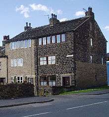
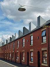
Greater Manchester's housing stock comprises a variety of types. Manchester city centre is noted for its high-rise apartments,[150] while Salford has some of the tallest and most densely populated tower block estates in Europe.[151] Saddleworth has stone-built properties, including farmhouses and converted weavers' cottages.[21][152] Throughout Greater Manchester, rows of terraced houses are common, most of them built during the Victorian and Edwardian periods. House prices and labour markets differ in Greater Manchester between north and south,[153][154] such that in the 2000s, the Housing Market Renewal Initiative identified Manchester, Salford, Rochdale and Oldham as areas with terraced housing unsuited to modern needs.[154] In contrast, towns and villages in southern Greater Manchester, from Bramhall through Woodford to Altrincham constitute an arc of wealthy commuter towns.[21] Altrincham in particular, with its neighbours Bowdon and Hale, forms a "stockbroker belt, with well-appointed dwellings in an area of sylvan opulence".[155]
Education
Greater Manchester has five universities: the Manchester Metropolitan University, the University of Bolton, the University of Law, the University of Manchester and the University of Salford. Together with the Royal Northern College of Music they had a combined population of students of 101,165 in 2007 – the third highest number in England behind Greater London (360,890) and the West Midlands (140,980),[156] and the thirteenth highest in England per head of population.[157] The majority of students are concentrated on Oxford Road in Manchester, Europe's largest urban higher education precinct.[158]
As of 2010, further education in Greater Manchester is co-ordinated by the Greater Manchester Colleges Group, a joint venture composed of an association of 24 colleges in the region.[159] Primary and secondary education within Greater Manchester are the responsibility of the constituent boroughs which form local education authorities and administer schools. The county has several independent schools such as Bolton School, Bury Grammar School, Manchester Grammar School, Oldham Hulme Grammar School, St Bede's College and Stockport Grammar School.
Economy


Much of Greater Manchester's wealth was generated during the Industrial Revolution, particularly textile manufacture.[160] The world's first cotton mill was built in the town of Royton,[161][162] and the county encompasses several former mill towns. An Association for Industrial Archaeology publication describes Greater Manchester as "one of the classic areas of industrial and urban growth in Britain, the result of a combination of forces that came together in the 18th and 19th centuries: a phenomenal rise in population, the appearance of the specialist industrial town, a transport revolution, and weak local lordship".[14] Much of the county was at the forefront of textile manufacture during the Industrial Revolution and into the early-20th century;[160] Peter Smith, Baron Smith of Leigh, chair of the Greater Manchester Combined Authority said "clearly, all of the Greater Manchester area was once at the heart of a very vibrant [textiles] industry",[160] represented by former textile mills found throughout the county.[14] The territory that makes up Greater Manchester experienced a rapid decline of these traditional sectors, partly during the Lancashire Cotton famine brought on by the American Civil War, but mainly as part of the post-war economic depression and deindustrialization of Britain that occurred during the 20th century.[147][163]
Considerable industrial restructuring has helped the region to recover from deindustrialisation and the demise of the mass production of textiles.[164] Historically, the docks at Salford Quays were an industrial port, though are now (following a period of disuse) a commercial and residential area which includes the Imperial War Museum North and The Lowry theatre and exhibition centre. The BBC is now established in their new home at MediaCityUK, at Salford Quays. This is home to BBC North West, several BBC departments, including BBC Sport, Blue Peter and, since April 2012, BBC Breakfast. Rochdale and Manchester are connected to the history of the cooperative movement; the Rochdale Society of Equitable Pioneers (an early consumer co-operative) was founded in Rochdale in 1844,[165] and The Co-operative Group, the UK's largest mutual business and North West England's biggest company,[166] is headquartered at One Angel Square in central Manchester.[167] Despite this economic diversification, as of November 2012, government plans are under development to revive textile production in Greater Manchester, and restore it as the national home of British textile manufacture.[160]
Today, Greater Manchester is the economic centre of the North West region of England and is the largest sub-regional economy in the UK outside London and South East England.[168] Greater Manchester represents more than £42 billion of the UK regional GVA, more than Wales, Northern Ireland or North East England.[169] Manchester city centre, the central business district of Greater Manchester, is a major centre of trade and commerce and provides Greater Manchester with a global identity, specialist activities and employment opportunities; similarly, the economy of the city centre is dependent upon the rest of the county for its population as an employment pool, skilled workforce and for its collective purchasing power.[170] Manchester today is a centre of the arts, the media, higher education and commerce. In a poll of British business leaders published in 2006, Manchester was regarded as the best place in the UK to locate a business.[171] A report commissioned by Manchester Partnership, published in 2007, showed Manchester to be the "fastest-growing city" economically.[172] It is the third most visited city in the United Kingdom by foreign visitors[173] and is now often considered to be the second city of the UK.[174] The Trafford Centre is one of the largest shopping centres in the United Kingdom, and is located within the Metropolitan Borough of Trafford.
At the 2001 UK census, there were 1,805,315 residents of Greater Manchester aged 16 to 74. The economic activity of these people was 40.3% in full-time employment, 11.3% in part-time employment, 6.7% self-employed, 3.5% unemployed, 5.1% students without jobs, 2.6% students with jobs, 13.0% retired, 6.1% looking after home or family, 7.8% permanently sick or disabled and 3.5% economically inactive for other reasons. The figures follow the national trend, although the percentage of self-employed people is below the national average of 8.3%.[175] The proportion of unemployment in the county varies, with the Metropolitan Borough of Stockport having the lowest at 2.0% and Manchester the highest at 7.9%.[176] In 2001, of the 1,093,385 residents of Greater Manchester in employment, the industry of employment was: 18.4% retail and wholesale; 16.7% manufacturing; 11.8% property and business services; 11.6% health and social work; 8.0% education; 7.3% transport and communications; 6.7% construction; 4.9% public administration and defence; 4.7% hotels and restaurants; 4.1% finance; 0.8% electricity, gas, and water supply; 0.5% agriculture; and 4.5% other. This was roughly in line with national figures, except for the proportion of jobs in agriculture which is only about a third of the national average of 1.5%, due to the overwhelmingly urban, built-up land use of Greater Manchester.[164][177]
| Year | Gross Value Added | Growth (%) |
|---|---|---|
| 2002 | 36,029 | 3.9% |
| 2003 | 38,094 | 5.7% |
| 2004 | 41,538 | 9.0% |
| 2005 | 43,042 | 3.6% |
| 2006 | 44,089 | 6.2% |
| 2007 | 47,975 | 5.0% |
| 2008 | 47,894 | -0.2% |
| 2009 | 48,634 | 1.5% |
| 2010 | 49,722 | 2.2% |
| 2011 | 49,461 | -0.5% |
| 2012 | 50,991 | 3.1% |
Transport


Public transport services in Greater Manchester are co-ordinated by Transport for Greater Manchester (TfGM), a public body with powers between those of a passenger transport executive and Transport for London,[179] established as SELNEC PTE in 1969 in accordance with the Transport Act 1968.[180] The original SELNEC Passenger Transport Executive was renamed as the Greater Manchester Passenger Transport Executive (GMPTE) when taken over by the Greater Manchester County Council on 1 April 1974 to co-ordinate public transport modes within the new county.[180] The council had overall responsibility for strategic planning and all policy decisions covering public transport (such as bus and rail services) and highways. GMPTE's purpose was to secure the provision of a completely integrated and efficient system of passenger transport for Greater Manchester on behalf of the county council.[180] In 1977, it was noted as the largest authority for public transport in the United Kingdom after London Transport.[180] GMPTE was renamed as Transport for Greater Manchester in April 2011 when it became a functional body of the Greater Manchester Combined Authority and obtained powers additional to those of a regular passenger transport executive from central government.[179]
Greater Manchester lies at the heart of the North West transport network. Much of the infrastructure converges at Manchester city centre with the Manchester Inner Ring Road, an amalgamation of several major roads, circulating the city centre. The county is the only place in the UK to have a fully orbital motorway,[181] the M60, which passes through all of the boroughs except Bolton and Wigan. Greater Manchester has a higher percentage of the motorway network than any other county in the country,[182] and according to the Guinness Book of World Records, it has the most traffic lanes side by side (17), spread across several parallel carriageways (M61 at Linnyshaw in Walkden, close to the M60 interchange).[183][184] Greater Manchester's 85 miles (137 km) of motorway network saw 5.8 billion vehicle kilometres in 2002 – about 6% of the UK's total, or 89,000 vehicles a day.[181] The A580 "East Lancs" road is a primary A road that connects Manchester and Salford with Liverpool. It was the UK's first purpose-built intercity highway and was officially opened by George V on 18 July 1934.[185] Throughout 2008, there were proposals for congestion charging in Greater Manchester.[186][187] Unlike the London scheme, two cordons would have been used, one covering the main urban core of the Greater Manchester Urban Area and another covering Manchester city centre.[188]
Metrolink is Greater Manchester's light rail system, which began operating in 1992. Principally used for suburban commuting, as of December 2014 the 57-mile (92 km) long network consists of seven lines which radiate from Manchester city centre and terminate at Altrincham, Ashton-under-Lyne, Bury, Didsbury, Eccles, Manchester Airport and Rochdale.[189] The system is owned by TfGM and operated and maintained under contract by RATP Group.[190][191] Greater Manchester has a heavy rail network of 142 route miles (229 km) with 98 stations, forming a central hub to the North West rail network.[192] Train services are provided by private operators and run on the national rail network which is owned and managed by Network Rail. There is an extensive bus network which radiates from Manchester city centre. The largest providers are First Greater Manchester for the northern parts of the county and Stagecoach Manchester for the southern parts. An extensive canal network also remains from the Industrial Revolution.
Manchester Airport, which is the third busiest in the United Kingdom, serves the county and wider region with flights to more worldwide destinations than any other airport in the UK.[193] Since June 2007 it has served 225 routes.[194] The airport handled 21.06 million passengers in 2008.
The three modes of public surface transport in the area are heavily used. 19.7 million rail journeys were made in the then GMPTE-supported area in the 2005/2006 financial year – an increase of 9.4% over 2004/2005; there were 19.9 million journeys on Metrolink; and the bus system carried 219.4 million passengers.[193]
Sports


Manchester hosted the 2002 Commonwealth Games which was, at a cost of £200M for the sporting facilities and a further £470M for local infrastructure, by far the biggest and most expensive sporting event held in the UK and the first to be an integral part of urban regeneration.[195] A mix of new and existing facilities were used. New amenities included the Manchester Aquatics Centre, Bolton Arena, the National Squash Centre, and the City of Manchester Stadium. The Manchester Velodrome was built as part of the Manchester bid for the 2000 Summer Olympics.[196] After the Commonwealth Games the City of Manchester Stadium was converted for football use, and the adjacent warm-up track upgraded to become the Manchester Regional Arena.[197] Other facilities continue to be used by elite athletes.[195] Cambridge Policy Consultants estimate 4,500 full-time jobs as a direct consequence, and Grattan points to other long-term benefits accruing from publicity and the improvement of the area's image.[195]
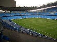
Association football is "woven into the cultural fabric of Greater Manchester", by way of its numerous football clubs – two of which play in the Premier League - which draw support, visitors and economic benefits to Greater Manchester valued at £330 million per year as of 2013.[198] The Manchester Football Association is the sport's governing body in Greater Manchester, and is committed to its promotion and development.[199] Manchester United F.C. are one of the world's best-known football teams, and in April 2008 Forbes estimated that they were the world's richest club.[200] They have won the League Championship a record twenty times (most recently in 2012-2013), the FA Cup a record twelve times, the Football League Cup four times and have been European Champions three times.[201] Their Old Trafford ground has hosted the FA Cup Final England international matches and the 2003 UEFA Champions League Final between Juventus and A.C. Milan. Manchester City F.C. moved from Maine Road to the City of Manchester Stadium after the 2002 Commonwealth Games. They have won the league championship four times (most recently in 2013-2014) and the FA Cup five times.[202] In addition, Wigan Athletic F.C. are one of the county's younger sides, and won their first major title in 2013, defeating Manchester City F.C. in the FA Cup final. They currently play in the Championship.[203] There is also Bolton Wanderers F.C., who also play in the Championship.[204] Oldham Athletic A.F.C. (founding members of Premier League) and Bury F.C. (two FA Cup wins) who play in League One, Rochdale A.F.C. who play in League One, Stockport County F.C. and F.C. United of Manchester who both play in the National League North.
In rugby league, the Wigan Warriors and the Salford Red Devils compete in the Super League, the top-level professional rugby league football club competition in Europe. Wigan have won the Super League/Rugby Football League Championship eighteen times, the Challenge Cup seventeen times, and the World Club Challenge three times.[205] Leigh Centurions and the Swinton Lions take part in the Championship, the sport's second tier, with 5 times Rugby Football League Championship and 3 times Challenge Cup winners Oldham Roughyeds and local rivals Rochdale Hornets in the third-tier Championship 1. There is also a large network of junior/community rugby league clubs across the metropolitan area which act as feeder teams to the elite sides. In rugby union, Stockport's Sale Sharks compete in the Guinness Premiership, and won the league in 2006.[206] Whitefield based Sedgley Park RUFC compete in National Division One, Manchester RUFC in National Division Two and Wigan side Orrell R.U.F.C. in National Division Three North.
Lancashire County Cricket Club began as Manchester Cricket Club and represents the (ancient) county of Lancashire. Lancashire contested the original 1890 County Championship. The team has won the County Championship nine times, most recently in 2011.[207] Their Old Trafford ground, near the football stadium of the same name, regularly hosts test matches. Possibly the most famous took place in 1956, when Jim Laker took a record nineteen wickets in the fourth test against Australia.[208] Cheshire County Cricket Club are a minor counties club who sometimes play in the south of the county.[209]
The Kirkmanshulme Lane stadium in Belle Vue is the home to top-flight speedway team the Belle Vue Aces and regular greyhound racing. Professional ice hockey returned to the area in early 2007 with the opening of a purpose-designed rink in Altrincham, the Altrincham Ice Dome, to host the Manchester Phoenix. Their predecessor, Manchester Storm, went out of business in 2002 because of financial problems that led to them being unable to pay players' wages or the rent for the Manchester Arena in which they played.[210][211]
Horse racing has taken place at several sites in the county. The two biggest courses were both known as Manchester Racecourse – though neither was within the boundaries of Manchester – and ran from the 17th century until 1963. Racing was at Kersal Moor until 1847 when the racecourse at Castle Irwell was opened. In 1867 racing was moved to New Barnes, Weaste, until the site was vacated (for a hefty price) in 1901 to allow an expansion to Manchester Docks. The land is now home to Dock 9 of the re-branded Salford Quays. Racing then moved back to Castle Irwell which later staged a Classic – the 1941 St. Leger – and was home to the Lancashire Oaks (nowadays run at Haydock Park) and the November Handicap, which was traditionally the last major race of the flat season. Through the late 50s and early 60s the track saw Scobie Breasley and Lester Piggott annually battle out the closing acts of the jockey's title until racing ceased on 7 November 1963.[212][213]
The Greater Manchester Athletics Association is the governing body of athletics in Greater Manchester, and organises events and competitions within Greater Manchester.[214] The Greater Manchester Marathon is a long-distance running event along a 26-mile and 385-yard course throughout the borough of Trafford.[215] Professional athletics takes place at the Regional Athletics Arena in Sportcity, which has hosted numerous national trials, Robin Park in Wigan, Longford Park in Stretford (home to Trafford Athletic Club), Woodbank Stadium in Stockport (home to Stockport Harriers) and the Cleavleys Track in Winton (home to Salford Harriers). As of 2008, new sports facilities including a 10,000 capacity stadium and athletics venue are being constructed at Leigh Sports Village.[216]
The Greater Manchester Community Basketball Club is an association which represents Greater Manchester in basketball.[217] It supports a variety of teams, including Manchester Magic.[218] The Greater Manchester County Crown Green Bowling Association appoints Junior, Senior and Veteran teams to represent Greater Manchester in the sport of bowls.[219][220] Founded by Greater Manchester's ten district councils in 1996, GreaterSport is the County Sports Partnership for Greater Manchester which works closely with the sports and physical activity sectors and coordinates events such as the Greater Manchester Youth Games.[221] The Greater Manchester Sports Fund aims to ensure that people in Greater Manchester aged 12–21 competing in any kind of sport, irrespective of background, are able to obtain grants of up to £750 so that they can better fulfil their potential.[222]
Culture
Art, tourism, culture and sport provide 16% of employment in Greater Manchester, with the proportion highest in Manchester.[223] In 2014, Will Straw remarked that "Greater Manchester is a creative powerhouse", recognised for its cultural output in areas such as association football, media and digital content, and guitar and dance music.[5]
Cuisine

There are several delicacies native to Greater Manchester.[224] Savoury dishes include Black pudding, a blood sausage typically associated with Bury and Bury Market; Pasty barm, a combined pasty-barm cake created in Bolton; and Rag pudding, a suet pastry pudding from Oldham filled with steak and onion and steamed in a cloth or wrapper to cook; the Manchester egg was introduced in 2010.[224] Sweet dishes include Eccles cake—native to Eccles—a small round flaky pastry cake filled with currants, sugar and spice; Manchester tart, a baked tart which consists of a shortcrust pastry shell spread with raspberry jam, covered with a custard filling and topped with flakes of coconut; and Uncle Joe's Mint Balls, traditional sweet mild mints manufactured in Wigan since their inception in 1898.[224] Vimto and Tizer are soft drinks invented in Manchester in 1908 and 1924 respectively.[224] Boddingtons is a bitter developed in Manchester and promoted as the "Cream of Manchester" in a popular 1990s advertising campaign credited with raising the city's profile.[225][226][227]
The Greater Manchester Campaign for Real Ale is a branch of the national Campaign for Real Ale, an advocacy group that supports, promotes and preserves the beer and drinks industry, and recognising outstanding venues with awards; The Nursery in Heaton Norris was its National Pub of the Year in 2001, and The Baum in Rochdale was its National Pub Of The Year in 2012.[228][229][230] The Manchester Food and Drink Festival was launched in 1997 as an urban beverage and gastronomy fair, principally held in Manchester city centre with further events throughout Greater Manchester;[231] smaller separate local events include the Prestwich Food and Drink Festival, the annual World Pie Eating Championship in Wigan, and the annual Ramsbottom Chocolate Festival.[232][233] As of 2012, Greater Manchester has no Michelin-starred restaurants, but three eateries in the Bib Gourmand category.[234]
Galleries, museums and exhibitions

The Greater Manchester Museums Group (GMMG) is a partnership of eight of the ten Museum Services in Greater Manchester.[235] Its exhibition centres include: Gallery Oldham, which has in the past featured work by Pablo Picasso;[236] Salford Museum and Art Gallery, a local museum with a recreated Victorian street;[237] and Bolton Museum, which houses material from private collectors, including geological specimens from the estate of Caroline Birley.[238] Separate from the GMMG is The Lowry at Salford Quays, which has a changing display of L. S. Lowry's work alongside travelling exhibitions. Manchester Art Gallery is a major provincial art gallery noted for its collection of Pre-Raphaelite art and housed in a Grade I listed building by Charles Barry.[239]
Greater Manchester's museums showcase the county's industrial and social heritage. The Hat Works in Stockport is the UK's only museum dedicated to the hatting industry; the museum moved in 2000 to a Grade II listed Victorian mill, previously a hat factory.[240] The Museum of Science and Industry in Manchester, amongst other displays, charts the rise of science and industry and especially the part Manchester played in its development; the Museums, Libraries and Archives Council described the displays as "pre-eminent collections of national and international importance".[241] Urbis began its life as a museum of the modern city, which attempted to explain the effects and experiences of life in the city. It was then transformed into an exhibition centre, which had its most successful year in 2006. Urbis entered its third phase since opening in 2012 as the National Football Museum.[242] Stockport Air Raid Shelters uses a mile of underground tunnels, built to accommodate 6,500 people, to illustrate life in the Second World War's air raid shelters.[243] The Imperial War Museum North in Trafford Park is one of the Imperial War Museum's five branches. Alongside exhibitions of war machinery are displays describing how people's lives are affected by war.[244] The Museum of Transport in Manchester, which opened in 1979, has one of the largest collections of vehicles in the country.[245] The People's History Museum is "the national centre for the collection, conservation, interpretation and study of material relating to the history of working people in Britain"; the museum is closed for redevelopment and will reopen in 2009.[246] The Pankhurst Museum is based in the early feminist Emmeline Pankhurst's former home and includes a parlour laid out in contemporary style.[247] Manchester United, Manchester City, and Lancashire CCC all have dedicated museums illustrating their histories. Wigan Pier, best known from George Orwell's book The Road to Wigan Pier,[248] was the name of a wharf on the Leeds and Liverpool Canal in Wigan. The name has been reused to describe an industrial-based visitor attraction, partly closed for redevelopment as of 2008.[249]
Media, film and television
The Greater Manchester Film Festival was launched in 2012. It is an international film festival designed to capitalise on Greater Manchester's "huge strengths in film and television, along with its growing media presence".[250] MediaCityUK, a host venue of the Greater Manchester Film Festival,[251] is a 200-acre (81 ha) mixed-use property development site at Salford Quays; its principal tenants are mass media organisations such as ITV Granada and the BBC. One of Greater Manchester's most lucrative and acclaimed television exports is Coronation Street, which is a televised soap opera set in Weatherfield, a fictional borough of Greater Manchester,[252][253] inspired by life in Salford.[254] Created by Tony Warren, Coronation Street was first broadcast on 9 December 1960, making it the world's longest-running TV soap opera in production.[255] It has been filmed in Manchester at Granada Studios since its inception, but filming is now done at a new set at MediaCityUK. Launched in 2004 by the Guardian Media Group, Channel M is a television station that broadcast local news and content about Greater Manchester.[256] It effectively closed in 2010.[257] In January 2011 Culture Secretary Jeremy Hunt stated that a new Greater Manchester channel will be available on Freeview by around 2013.[258]
The Manchester Evening News is a regional daily newspaper covering Greater Manchester, published every day except Sunday.[259] It is owned by Trinity Mirror and produced by MEN Media. It sells around 81,000 copies a day and gives away nearly 100,000, making it the market leader in Greater Manchester.[260] The paper was first published in 1868 by Mitchell Henry as part of his Parliamentary election campaign for the Manchester constituency.[259] MEN Media "dominates Greater Manchester", reaching 7 out of 10 adults each week within the region through its portfolio of products which also includes the Oldham Advertiser, the Rochdale Observer, and the Salford Advertiser.[261]
Music, theatre and performing arts

Greater Manchester has the highest number of theatre seats per head of population outside London. Most, if not all, of the larger theatres are subsidised by local authorities or the North West Regional Arts Board.[263] The Royal Exchange Theatre formed in the 1970s out of a peripatetic group staging plays at venues such as at the University [of Manchester] Theatre and the Apollo Theatre. A season in a temporary stage in the former Royal Exchange, Manchester was followed by funding for a theatre in the round, which opened in 1976.[264] The Lowry — Greater Manchester's most visited tourist attraction[262] — houses two theatres, used by travelling groups in all the performing arts.[223][265] The Opera House is a 1,900-seat venue hosting travelling productions, often musicals just out of the West End.[266] Its sister venue, The Palace, hosts generally similar shows. The Oldham Playhouse, one of the older theatres in the region, helped launch the careers of Stan Laurel and Charlie Chaplin. Its productions are described by the 2007 CityLife guide as 'staunchly populist' – and popular.[266] There are many other venues scattered throughout the county, of all types and sizes.[266]
Greater Manchester has four professional orchestras, all based in Manchester. The Hallé Orchestra is the UK's oldest symphony orchestra (and the fourth oldest in the world),[267] supports a choir and a youth orchestra, and releases its recordings on its own record label.[268] The Hallé is based at the Bridgwater Hall but often tours, typically giving 70 performances "at home" and 40 on tour.[268] The BBC Philharmonic Orchestra, one of five BBC orchestras, can trace its history back to the early days of radio broadcasting in 1926.[269] As of 2008 it is based at the BBC's Oxford Road studios,[270] but is expected to move to MediaCityUK in Salford.[271] The Manchester Camerata and the Northern Chamber Orchestra are smaller, though still professional, organisations.[272] The main classical venue is the 2,341-seat Bridgewater Hall in Manchester, opened in 1996 at a cost of £42m.[273] Manchester is also a centre for musical education, via the Royal Northern College of Music and Chetham's School of Music.[274]
The Manchester Arena seats over 21,000, and is the largest indoor arena in Europe. It has been voted International Venue of the Year, and for several years was the most popular venue in the world.[275] The sports grounds in the county also host large pop concerts.[276] A new flexible, large-scale cultural, arts, and exhibition space named The Factory is to be built on the former site of Granada Studios in central Manchester.[277] It is named with reference to Factory Records, a Manchester-based independent record label, founded in 1978 by Tony Wilson and Alan Erasmus. Factory Records — which featured acts such as Joy Division, New Order, and the Happy Mondays — and The Haçienda, served as a catalyst in the late-1980s for a blending of alternative rock, psychedelic rock and electronic dance music known as Madchester. Greater Manchester continues to be associated with guitar and dance music.[5]
See also
- Outline of England
- Grade I listed buildings in Greater Manchester
- Grade II* listed buildings in Greater Manchester
- Greater Manchester Employer Coalition
- List of people from Greater Manchester
- List of public art in Greater Manchester
- Parliament of the United Kingdom Relocation
- Healthcare in Greater Manchester
References
Notes
- ↑ "2014 Mid Year Estimates – MCC". manchester.gov.uk. Retrieved 28 February 2014.
- 1 2 "UK Standard Area Measurements (SAM)". Office for National Statistics. Retrieved 28 September 2012.
- 1 2 Office for National Statistics. "Gazetteer of the old and new geographies of the United Kingdom" (PDF). statistics.gov.uk. p. 48. Archived from the original (PDF) on 8 March 2008. Retrieved 2 March 2014.
Office for National Statistics (17 September 2004). "Beginners' Guide to UK Geography: Metropolitan Counties and Districts". ons.gov.uk. Retrieved 8 August 2013.
"North West". The Electoral Commission. Archived from the original on 14 November 2008. Retrieved 2 March 2014. - 1 2 3 "Greater Manchester Gazetteer". Greater Manchester County Record Office. Places names – G to H. Retrieved 17 June 2008.
- 1 2 3 Straw, Will (5 March 2014). "Greater Manchester is a creative powerhouse". theguardian.com. Retrieved 16 December 2014.
- ↑ Nevell & Redhead 2005, p. 20.
- ↑ Adrian Morris. "Roman Wigan". Wigan Archaeological Society. Retrieved 10 July 2008.
- ↑ Bayliss 1996, p. 6.
- ↑ Historic England. "Mamucium Roman fort (76731)". PastScape. Retrieved 29 December 2007.
- ↑ Historic England. "Castle Shaw (45891)". PastScape. Retrieved 29 December 2007.
- ↑ Hartwell, Hyde & Pevsner 2004, p. 18, quoting Redhead, Norman
- ↑ Frangopulo 1977, p. ix.
- ↑ Frangopulo 1977, pp. 24–25.
- 1 2 3 4 McNeil & Nevell 2000, pp. 1–3.
- 1 2 3 4 5 6 7 8 "55: Manchester Conurbation" (PDF). naturalengland.org.uk. 18 July 2013. Retrieved 5 August 2013.
- ↑ Aspin 1981, p. 3.
- 1 2 Carter 1962, p. 49.
- ↑ Cowhig 1976, pp. 7–9.
- ↑ Kidd 2006, pp. 12,15–24, 224.
- 1 2 Hall, Peter (1998). "The first industrial city: Manchester 1760–1830". Cities in Civilization. Weidenfeld & Nicolson. ISBN 0-297-84219-6.
- 1 2 3 4 5 Schofield 2003, pp. 34–35.
- 1 2 3 Frangopulo 1977, p. 226.
- ↑ Frangopulo 1977, p. 268.
- ↑ Swarbrick, J. (February 1914). Greater Manchester: The Future Municipal Government of Large Cities. Institution of Municipal and County Engineers. pp. 12–15.
- ↑ Frangopulo 1977, p. 229.
- ↑ Clark 1973, p. 1.
- 1 2 Frangopulo 1977, p. 227.
- 1 2 3 Frangopulo 1977, p. 228.
- ↑ Frangopulo 1977, p. 231.
- ↑ Frangopulo 1977, p. 234.
- 1 2 3 Redcliffe-Maud 1969, pp. 219–235.
- ↑ Frangopulo 1977, p. 233.
- ↑ Frangopulo 1977, p. 264.
- ↑ The SELNEC Preservation Society. "The Formation of the SELNEC PTE". selnec.org.uk. Retrieved 6 July 2008.
- 1 2 3 Redcliffe-Maud & Wood 1975, pp. 46–7, 56, 157.
- ↑ Parliamentary Debates (Hansard). House of Commons. 6 July 1972. col. 763–834.
- ↑ "Lancashire saved from 'Botchdale'". The Times. 7 July 1972. p. 8.
- ↑ "Philosophy on councils has yet to emerge". The Times. 8 July 1972. p. 2.
- 1 2 HMSO. Local Government Act 1972. 1972 c.70
- ↑ At 31 March 1974, Ringway was a civil parish in the Bucklow Rural District.
- ↑ Office of the Deputy Prime Minister. "Local Government Finance Statistics England No.16". local.odpm.gov.uk. Archived from the original on 7 August 2011. Retrieved 2 March 2014.
- ↑ "British Local Election Database, 1889–2003". Arts and Humanities data service. 28 June 2006. Retrieved 5 March 2008.
- ↑ "All change in local affairs". The Times. 1 April 1974. p. 15.
- ↑ Frangopulo 1977, p. xii.
- ↑ Clark 1973, p. 101.
- ↑ Frangopulo 1977, p. 246.
- ↑ Bristow & Cross 1983, p. 30.
- ↑ Frangopulo 1977, pp. 246, 255.
- 1 2 3 Wannop 2002, pp. 144–145.
- ↑ Parkinson-Bailey 2000, pp. 214–5.
- ↑ Taylor, Evans & Fraser 1996, p. 76.
- 1 2 3 4 Clapson 2010, pp. 123–124.
- ↑ "Changes in local government units may cause some famous names to disappear". The Times. 2 January 1973. p. 2.
•"Post Office will ignore some new counties over addresses". The Times. 26 November 1973. p. 3. - ↑ Address Management Guide. Royal Mail. 2004.
- 1 2 Wilson & Game 2002, p. 61.
- ↑ Walker, David (15 January 1983). "Tory plan to abolish GLC and metropolitan councils, but rates stay". The Times. p. 2.
•Haviland, Julian (5 May 1983). "Tories may abolish county councils if they win election". The Times. p. 1.
•Tendler, Stewart (16 June 1983). "Big cities defiant over police". The Times. p. 2. - ↑ "Angry reaction to councils White Paper". The Times. 8 October 1983. p. 22.
- ↑ Wilson & Game 2002, p. 62.
- ↑ Association of Greater Manchester Authorities. "About AGMA". agma.gov.uk. Archived from the original on 15 September 2008. Retrieved 5 March 2008.
- ↑ BISER Europe Regions Domain Reporting (2003). "Regional Portrait of Greater Manchester – 5.1 Spatial Structure" (PDF). biser-eu.com. Archived from the original (PDF) on 18 October 2006. Retrieved 2 March 2014.
- ↑ HMSO. Lieutenancies Act 1997. 1997 c.23.
- ↑ Wood, Edward (11 December 1998). Research Paper 98/115 –The Greater London Authority Bill: A Mayor and Assembly for London – Bill 7 of 1998–99 (PDF). House of Commons Library.
- ↑ HM Treasury (17 July 2007). "Sub-national economic development and regeneration review". hm-treasury.gov.uk. Archived from the original on 15 December 2007. Retrieved 2 March 2014.
- ↑ Fairley, Peter (18 January 2008). "Comment – A faster track for the city-regions". publicfinance.co.uk. Archived from the original on 5 January 2009. Retrieved 29 September 2012.
- ↑ Ottewell, David (25 June 2008). "Now YOU can vote on congestion charge". Manchester Evening News. pp. 1–2.
- ↑ "More than the sum of their parts – partnerships seal deal to increase economic growth". communities.gov.uk. 14 July 2008. Archived from the original on 3 August 2008. Retrieved 16 July 2008.
- ↑ "Date set for C-charge referendum". news.bbc.co.uk. 29 September 2008. Retrieved 5 January 2010.
- ↑ Sturcke, James (12 December 2008). "Manchester says no to congestion charging". guardian.co.uk. Retrieved 12 December 2008.
- 1 2 3 Association of Greater Manchester Authorities (2009). "City Region Governance: A consultation on future arrangements in Greater Manchester" (PDF). agma.gov.uk. Archived (PDF) from the original on 19 March 2010. Retrieved 18 March 2010.
- ↑ Association of Greater Manchester Authorities. "City Region". agma.gov.uk. Archived from the original on 14 March 2010. Retrieved 18 March 2010.
- ↑ HM Treasury (16 December 2009). "Greater Manchester granted city region status". hm-treasury.gov.uk. Archived from the original on 21 December 2009. Retrieved 2 March 2014.
- ↑ "John Denham – Greater Manchester to be country's first ever Combined Authority". communities.gov.uk. 31 March 2010. Retrieved 18 October 2010.
- ↑ "Plan to end rail and road misery". thisislancashire.co.uk. 31 March 2010. Retrieved 31 March 2010.
- ↑ "Greater Manchester to become first 'city region'". Oldham Advertiser. oldhamadvertiser.co.uk. 29 March 2010. Retrieved 30 March 2010.
- ↑ "Greater Manchester agrees to combined authority". Manchester City Council. 29 March 2010. Retrieved 31 March 2010.
- ↑ "Safeguard to prevent C-charge is welcomed". theboltonnews.co.uk. 9 December 2010. Retrieved 14 December 2010.
- ↑ HM Treasury and The Rt Hon George Osborne MP (3 November 2014). "Manchester to get directly elected Mayor". gov.uk. Retrieved 5 December 2014.
- 1 2 "Greater Manchester to control £6bn NHS budget". BBC News. bbc.co.uk. 25 February 2015. Retrieved 26 February 2015.
- ↑ Dawson 1992, "Chapter 6: The County Tops".
- 1 2 3 4 Greater Manchester Passenger Transport Authority. "The Greater Manchester Area and its Regional Context". gmltp.co.uk. Archived from the original on 27 September 2007. Retrieved 2 March 2014.
- 1 2 Manchester City Council (11 July 2012). "Manchester's Local Development Framework: Core Strategy Development Plan Document" (PDF). manchester.gov.uk. Retrieved 16 June 2013.
Part of the City Centre is in Salford and both the Regional Centre and Inner Areas cover areas of Manchester, Salford and Trafford... Manchester City Centre is defined as the area inside the Inner Relief Route and extends to the south to encompass the Oxford Road Corridor. The City Centre also extends to Chapel Street, within the administrative boundary of Salford City Council.
- ↑ Ravetz 2000, p. 50.
- 1 2 Association of Greater Manchester Authorities (August 2009). "Prosperity for all: The Greater Manchester Strategy" (PDF). agma.gov.uk. Archived (PDF) from the original on 20 January 2014. Retrieved 22 June 2013.
- 1 2 "Greater Manchester councils plan "unique" town centre investment strategy". localgovernmentexecutive.co.uk. 19 March 2013. Retrieved 22 June 2013.
- ↑ Manchester City Council (1995), Manchester Unitary Development Plan, p. 105
- ↑ TfGM; GMCA (2011). Greater Manchester's third Local Transport Plan 2011/12 – 2015/16 (PDF). Transport for Greater Manchester.
- ↑ Kellie 2010, pp. 4-5, 243.
- ↑ Freeman & Snodgrass 1959, p. 155.
- 1 2 3 "2011 Census - Built-up areas". ONS. Retrieved 1 July 2013.
- ↑ "State of the English Cities: Volume 1". Office of the Deputy Prime Minister. 2006. Retrieved 17 December 2006.
- ↑ From Territorial Cohesion to the New Regionalized Europe. Retrieved 5 October 2014.
- ↑ ESPON
- ↑ Groom, Brian. "A great northern conurbation". 20 June 2014. Financial Times London UK. Retrieved 19 March 2015.
- 1 2 "Manchester Airport 1971–2000 weather averages". Met Office. 2001. Retrieved 15 July 2007.
- 1 2 "UK 1971–2000 averages". Met Office. 2001. Retrieved 15 July 2007.
- ↑ "Annual UK weather averages". Met Office. 2007. Retrieved 23 April 2007.
- ↑ "Roads chaos as snow sweeps in Manchester". Manchester Evening News. 2005. Retrieved on 15 July 2007.
- ↑ "Peak District sightseer's guide – Snake Pass". highpeak.co.uk. 2002. Retrieved 6 July 2007.
- ↑ "Icy conditions hit the UK after days of heavy snow". BBC News. news.bbc.co.uk. 7 January 2010. Retrieved 7 January 2010.
- ↑ "Manchester 1981-2010 Averages". Met Office. Retrieved 30 January 2016.
- ↑ "Manchester Ringway 1961-1990". NOAA. Retrieved 30 January 2016.
- ↑ "Manchester ringway extreme values". KNMI. Retrieved 30 January 2016.
- 1 2 3 4 5 6 "Greater Manchester Biodiversity". gmbp.org.uk. Retrieved 7 September 2012.
- 1 2 3 Hardy 1998, p. 7.
- ↑ Manchester City Council. "Sites of Biological Importance". wildaboutmanchester.info. Retrieved 7 September 2012.
- 1 2 Defra (2002). Aitchison, J.W., ed. "The Commonlands of Greater Manchester: A Biological Survey" (PDF). defra.gov.uk. Archived (PDF) from the original on 1 November 2012. Retrieved 7 September 2012.
- ↑ Greater Manchester Local Record Centre. "Welcome to Greater Manchester LRC". gmwildlife.org.uk. Retrieved 7 September 2012.
- ↑ Greater Manchester Bidiversity Project. "What is biodiversity?". gmbp.org.uk. Retrieved 7 September 2012.
- ↑ "Welcome to the Manchester Field Club". webspace.mypostoffice.co.uk. Retrieved 7 September 2012.
- ↑ Salford City Council (2007). "Chat Moss". salford.gov.uk. Archived from the original on 28 September 2008. Retrieved 13 November 2007.
•"Agricultural Land Classification" (PDF). Department for Environment, Food and Rural Affairs. July 2003. Archived from the original (PDF) on 25 February 2009. Retrieved 2 March 2014. - ↑ "Appendix J River Mersey Case Study Report" (DOC). The Countryside Agency. Retrieved 27 April 2007.
- ↑ "South Pennine Moors". Defra. Retrieved 21 July 2012.
- ↑ Lashley, Brian (20 March 2003). "So what bloom best suits you?". Manchester Evening News. menmedia.co.uk. Retrieved 7 September 2012.
- ↑ Devon Wildlife Trust. "Species – Cottongrass, common". devonwildlifetrust.org. Archived from the original on 26 June 2015. Retrieved 7 September 2012.
- ↑ Plantlife International. "North-west England". plantlife.org.uk. Retrieved 7 September 2012.
- ↑ Holland, Spence & Sutton 1984, pp. 28–29.
- 1 2 3 4 Association of Greater Manchester Authorities (March 2010). "Greater Manchester Combined Authority Final Scheme" (PDF). agma.gov.uk. Archived (PDF) from the original on 23 September 2010. Retrieved 30 March 2010.
- ↑ "Devolution to the Greater Manchester Combined Authority and transition to a directly elected mayor". gov.uk. Retrieved 4 November 2014.
- 1 2 3 Frangopulo 1977, p. 138.
- 1 2 Barlow, Max (May 1995). "Greater Manchester: conurbation complexity and local government structure". Political Geography. Elsevier. 14 (4): 379–400. doi:10.1016/0962-6298(95)95720-I.
- ↑ Rochdale Metropolitan Borough Council, p. 65.
- ↑ Walker, Jonathan (9 September 2008). "Goodbye West Midlands, hello Greater Birmingham". Birmingham Post. birminghampost.net. Retrieved 24 September 2012.
- ↑ Wannop 2002, p. 148.
- ↑ "Greater Manchester Local Transport Plan". gmltp.co.uk. Retrieved 12 December 2006.
- ↑ "Introducing new police commissioner Tony Lloyd - the most powerful man in Greater Manchester?". Manchester Evening News. menmedia.co.uk. 16 November 2012. Archived from the original on 22 November 2012. Retrieved 2 March 2014.
- ↑ "Manchester Airports Group dividend windfall for councils". bbc.co.uk. 21 July 2013. Retrieved 8 August 2013.
- ↑ Hebbert, Michael; Deas, Iain (January 2000). "Greater Manchester – 'up and going'?". Policy & Politics. Ingentaconnect. 28 (1): 79–92. doi:10.1332/0305573002500848.
- ↑ Chancellor of the Duchy of Lancaster. "Keeper of the Rolls". duchyoflancaster.co.uk. Archived from the original on 15 December 2010. Retrieved 2 March 2014.
- ↑ The Lord-Lieutenants Order 1973 (1973/1754)
- ↑ The London Gazette: no. 58395. p. 10329. 18 July 2007.
- ↑ "Greater Manchester Met. C". visionofbritain.org.uk. Retrieved 6 April 2007.
- ↑ "Lib Dems close in on Manchester". Manchester Evening News. 11 June 2004. Retrieved 26 February 2006.
- ↑ "Labour party returns to Manchester". timeout.com. 2006. Archived from the original on 13 January 2008. Retrieved 2 March 2014.
- ↑ "Greater Manchester Met. C: Total Population". visionofbritain.org.uk. Retrieved 24 September 2012.
- ↑ "2014 Mid Year Estimates – MCC". manchester.gov.uk. Retrieved 28 February 2014.
- ↑ "T 09: Quinary age groups and sex for local authorities in the UK; estimated resident population Mid-2006 Population Estimates". National Statistics. 30 May 2008. Retrieved 8 July 2008.
- ↑ Clark 1973, p. 93.
- ↑ "Regional Portrait of Greater Manchester – 5.3 Population Structure/Migration (demography)" (PDF). BISER Europe Regions Domain Reporting. 2003. Archived from the original (PDF) on 8 July 2011. Retrieved 18 February 2008.
- ↑ "Warren Smith welcomes you to the Greater Manchester Lieutenancy". manchesterlieutenancy.org. Retrieved 8 July 2008.
- ↑ "Exodus: The Facts". can.uk.com. 2003. Archived from the original on 4 February 2008. Retrieved 2 March 2014.
- ↑ "Greater Manchester (health authority) religion". Statistics.gov.uk. Retrieved 1 February 2008.
- ↑ "Catholic Diocese of Shrewsbury". Dioceseofshrewsbury.org. Retrieved 7 May 2007.
- ↑ "Parishes of the Diocese". Salforddiocese.org.uk. Archived from the original on 2 May 2007. Retrieved 7 May 2007.
- ↑ "The Church of England Diocese of Manchester". manchester.anglican.org. Retrieved 17 January 2008.
- ↑ "Welcome to the Diocese of Liverpool". liverpool.anglican.org. Retrieved 1 February 2008.
- ↑ "Market Renewal: Manchester Salford Pathfinder" (PDF). Audit Commission. 2003. Retrieved 2 March 2014.
- 1 2 3 4 5 "Shrinking Cities: Manchester/Liverpool II" (PDF). shrinkingcities.com. March 2004. p. 36. Retrieved 4 March 2008.
- ↑ Cooper 2005, p. 47.
- ↑ Shapely, Peter (2002). "The press and the system built developments of inner-city Manchester" (PDF). Manchester Region History Review. Manchester Centre for Regional History. 16: 30–39. ISSN 0952-4320. Archived from the original (PDF) on 1 December 2007. Retrieved 2 March 2014.
- ↑ Qureshi, Yakub (24 November 2004). "A cut above: high rise living is back". BBC. Retrieved 25 February 2008.
- ↑ Cunningham, John (28 February 2001). "Tower blocks to make a comeback". The Guardian. Retrieved 26 February 2008.
- ↑ Dyckhoff, Tom (9 December 2011). "Let's move to: Saddleworth, Greater Manchester". The Guardian. Retrieved 30 September 2012.
- ↑ Kirby, Dean (24 August 2013). "Street where houses cost just £15,000 - we reveal cheapest and dearest homes in Greater Manchester". Manchester Evening News. Retrieved 24 August 2013.
- 1 2 Bontje, Musterd & Pelzer 2011, p. 159.
- ↑ Frangopulo 1977, p. 224.
- ↑ "Table 0a – All students by institution, mode of study, level of study, gender and domicile 2006/07" (XLS). Students and Qualifiers Data Tables. Higher Education Statistics Agency. 2008. Retrieved 21 March 2008.
- ↑ Tight, Malcolm (July 2007). "The (Re)Location of Higher Education in England (Revisited)". Higher Education Quarterly. 61 (3): 250–265. doi:10.1111/j.1468-2273.2007.00354.x.
- ↑ Hartwell 2001, p. 105.
- ↑ "Manchester College's "strong management"". manchestermule.com. 27 May 2010. Retrieved 29 June 2013.
- 1 2 3 4 "Manchester to revive Britain's textile trade with reborn Cottonopolis". Manchester Evening News. menmedia.co.uk. 3 November 2012. Retrieved 4 November 2012.
- ↑ "Oldham's Economic Profile – Innovation and Technology". Oldham Council. Archived from the original on 13 January 2007. Retrieved 2 March 2014.
- ↑ "NW Cotton Towns Learning Journey". Spinning the web. Manchester City Council. Retrieved 27 October 2006.
- ↑ "The rise of the 'greatest village in England'". Manchester Evening News. menmedia.co.uk. 3 November 2012. Retrieved 3 November 2012.
- 1 2 "Regional Portrait of Greater Manchester – 6 Economic Factors" (PDF). BISER Europe Regions Domain Reporting. 2003. Archived from the original (PDF) on 18 October 2006. Retrieved 2 March 2014.
- ↑ "Our History". co-operative.coop. Retrieved 18 December 2014.
- ↑ Roue, Lucy (27 November 2014). "200 staff to undergo consultation process at Co-operative's Manchester head office One Angel Square". manchestereveningnews.co.uk. Retrieved 18 December 2014.
- ↑ Begum, Shelina (14 November 2013). "Co-op's headquarters declared greenest building in the world". manchestereveningnews.co.uk.
- ↑ "Manchester city region – Economic Overview". investinmanchester.com. Archived from the original on 21 March 2008. Retrieved 2 March 2014.
- ↑ "Greater Manchester Economic Data". Midas Manchester. 2003. Archived from the original on 13 August 2007. Retrieved 10 July 2008.
- ↑ "The Greater Manchester Strategy: Foreword". gmep.org.uk. 2004. Archived from the original on 22 April 2008. Retrieved 9 July 2008.
- ↑ "Britain's Best Cities 2005–2006 Executive Summary" (PDF). OMIS Research. 2006. Archived from the original (PDF) on 26 February 2008. Retrieved 17 July 2008.
- ↑ "Manchester – The State of the City". Manchester City Council. 2007. Retrieved 11 September 2007.
- ↑ "International Visitors To Friendly Manchester Up 10%" (Press release). Marketing Manchester. 17 September 2007. Archived from the original on 27 October 2007. Retrieved 17 July 2008.
- ↑ "Manchester 'England's second city'". BBC. 12 September 2002. Retrieved 5 January 2010.
• Riley, Catherine (8 July 2005). "Can Birmingham halt its decline?". The Times. Retrieved 31 March 2010.
• "Manchester 'close to second city'". BBC. 29 September 2005. Retrieved 5 January 2010.
• "Manchester tops second city poll". BBC. 10 February 2007. Retrieved 5 January 2010.
• "Birmingham loses out to Manchester in second city face off". BBC. 2007. Retrieved 18 June 2007. - ↑ "Greater Manchester (health authority) economic activity". statistics.gov.uk. Retrieved 3 February 2008.
- ↑ "Promoting a Dynamic Economy". Greater Manchester e-Government Partnership. Archived from the original on 12 January 2008. Retrieved 12 December 2007.
- ↑ "Greater Manchester (health authority) industry of employment". statistics.gov.uk. Retrieved 3 February 2008.
- ↑ "Regional Gross Value Added (pp. 240–253)" (PDF). Office for National Statistics. 21 December 2005. Archived from the original (PDF) on 1 December 2007. Retrieved 2 March 2014.
- 1 2 Kirby, Dean (1 April 2011). "All Change: Greater Manchester Passenger Transport Executive becomes Transport for Greater Manchester – With a New Logo of Course". Manchester Evening News. menmedia.co.uk. Retrieved 5 April 2011.
- 1 2 3 4 Frangopulo 1977, p. 187.
- 1 2 Hyde, O'Rourke & Portland 2004, p. 141.
- ↑ The Oldham College. "Local information: About Oldham". oldham.ac.uk. Archived from the original on 9 October 2006. Retrieved 6 March 2008.
The Metropolitan County of Greater Manchester has the most extensive motorway network in the United Kingdom
- ↑ "British Roads Database". cbrd.co.uk. Retrieved 6 March 2008.
•"The number's up for Britain's roads". The Daily Telegraph. October 2002. Archived from the original on 14 October 2007. Retrieved 2 March 2014.The west side of Manchester is notoriously busy and holds the record for the widest section of motorway – an impressive 17 lanes where the M61 and M60 meet.
- ↑ Matthews 1992, p. 121.
- ↑ Lancashire County Council. "Early Highways Liverpool-East Lancashire Road A580". Historic Highways. lancashire.gov.uk. Archived from the original on 22 February 2008. Retrieved 19 January 2008.
- ↑ Salter, Alan (5 May 2007). "C-charge details revealed". Manchester Evening News. Retrieved 25 November 2007.
- ↑ "Manchester makes move towards congestion charge". The Guardian. 27 July 2007. Retrieved 31 March 2010.
- ↑ "Traffic Congestion charging: FAQs". BBC Manchester. Retrieved 26 November 2007.
- ↑ Britton, Paul (13 October 2014). "New Metrolink line to Wythenshawe and Manchester Airport to open on November 3 – a year ahead of schedule". manchestereveningnew.co.uk. Retrieved 18 December 2014.
- ↑ Salford City Council (February 2012). "Salford Infrastructure Delivery Plan" (PDF). salford.gov.uk. Retrieved 22 January 2013.
- ↑ "RATP buys Manchester Metrolink operator". Railway Gazette International. London. 2 August 2011.
- ↑ GMPTE. "GMPTE – Trains". gmpte.com. Archived from the original on 15 December 2006. Retrieved 2 March 2014.
- 1 2 "State of the City Report 2006/2007" (PDF). manchester.gov.uk. September 2007. Archived from the original (PDF) on 4 January 2008. Retrieved 2 March 2014.
- ↑ "Manchester Airport offers more destinations than Heathrow and Gatwick". UK Airport News. TMC Ltd. 3 June 2006. Retrieved 10 July 2008.
- 1 2 3 Gratton, Chris; Simon Shibli; Richard Coleman (2005). "Sport and Economic Regeneration in Cities". Urban Studies. Urban Studies Journal Limited. 42 (5–6): 985–999. doi:10.1080/00420980500107045.
- ↑ Parkinson-Bailey 2000, pp. 249–250.
- ↑ "City enjoys £600m windfall". BBC Online. 16 June 2006. Retrieved 5 January 2010.
"Sporting Legacy". Commonwealth Games Legacy Manchester 2002. Commonwealth Games Legacy. 2003. Archived from the original on 28 August 2007. Retrieved 23 September 2007. - ↑ Jupp, Adam (11 April 2013). "£300m: The staggering amount Manchester makes from football every year". Manchester Evening News. manchestereveningnews.co.uk. Retrieved 16 April 2013.
- ↑ "What we do". Manchester FA. Retrieved 2 October 2012.
- ↑ "Soccer Team Valuations No. 1 Manchester United". Forbes. Forbes.com LLC. 30 April 2008. Retrieved 2 May 2008.
- ↑ "Glory, Glory, Man United". The website of dreams. Retrieved 2 June 2008.
- ↑ "Roll of honour". Manchester City FC. Archived from the original on 10 December 2007. Retrieved 2 March 2014.
- ↑ "Brief history of Wigan Athletic". Wigan Athletic Football Club. 11 June 2007. Archived from the original on 6 January 2008. Retrieved 2 March 2014.
- ↑ "Cup Final Statistics". The Football Association. 2001–2008. Retrieved 2 May 2008.
- ↑ "Honours". wiganwarriors.com. Wigan Warriors. 2008. Archived from the original on 12 April 2008. Retrieved 3 May 2008.
- ↑ "BBC Rugby Union – English – Sale 45-20 Leicester". BBC. 27 May 2006. Retrieved 5 January 2010.
- ↑ "Champions At Last". LCCC.co.uk. Retrieved 4 November 2014.
- ↑ "Jim Laker". Cricinfo. Retrieved 2 May 2008.
- ↑ "Minor County Grounds". Minor Counties Cricket Association. Cricinfo. Retrieved 2 May 2008.
- ↑ Hughes, Stuart (5 November 2002). "D-day for Storm". BBC Online. Retrieved 5 January 2010.
- ↑ Hughes, Stuart (12 November 2002). "Storm sink as cash bid fails". BBC Online. Retrieved 5 January 2010.
- ↑ Ramsden 1966.
- ↑ Salford Metropolitan Borough Council. "Transcript of Kersal Dale Video". Salford.gov.uk. Retrieved 5 March 2008.
•Farrer, William; Brownbill, John (2003–2006) [1911]. "Townships: Broughton". The Victoria history of the county of Lancaster – Lancashire. 4. University of London & History of Parliament Trust. pp. 217–222. Retrieved 25 February 2008. - ↑ "Greater Manchester Athletics Association". greatermanchesteraa.co.uk. Retrieved 4 May 2011.
- ↑ Greater Manchester Marathon Ltd (2012). "General Information". greatermanchestermarathon.com. Retrieved 28 April 2012.
- ↑ "Leigh Sports Village". Leigh Sports Village. Archived from the original on 24 April 2008. Retrieved 2 May 2008.
- ↑ "Aims and Objectives". amaechibasketballcentre.com. Retrieved 4 May 2011.
- ↑ "Manchester's basketball club prove they are magic as teams qualify for cup final". manchester.gov.uk. 6 March 2006. Retrieved 4 May 2011.
- ↑ "Official Website of Greater Manchester County Crown Green Bowling Association". gmbowls.org.uk. 2 May 2011. Retrieved 5 May 2011.
- ↑ "County team dodge a bullet". Oldham Evening Chronicle. oldham-chronicle.co.uk. 3 May 2011. Retrieved 4 May 2011.
- ↑ GreaterSport. "About GreaterSport: Greater Manchester Sports Partnership". greatersport.co.uk. Archived from the original on 22 November 2012. Retrieved 2 October 2012.
- ↑ "Greater Manchester Sports Fund". manchestercommunitycentral.org. Retrieved 4 May 2011.
- 1 2 Robson, Brian (2004). "Culture and the City: A View from the 'Athens of the North'". Built Environment. 30 (3): 246–255. doi:10.2148/benv.30.3.246.54298.
- 1 2 3 4 Visit Manchester. "Greater Manchester local delicacies". visitmanchester.com. Retrieved 27 September 2012.
- ↑ Taylor, Paul (9 September 2004). "How city's pride fell to big business". Manchester Evening News. menmedia.co.uk.
- ↑ Hall, William (28 October 2004). "Manchester united in battle over Boddingtons". Financial Times. London. Retrieved 22 October 2011.(subscription required)
- ↑ Taylor, Paul R (13 July 2007). "Chimney survives rubble and strife". Manchester Evening News. menmedia.co.uk.
- ↑ "Rochdale 'boozer' The Baum crowned Britain's best pub". BBC News. bbc.co.uk. 13 February 2013. Retrieved 20 December 2014.
- ↑ Slater, Chris (12 September 2013). "Rochdale pub aims to be named Britain's best for second year running at CAMRA awards". manchestereveningnews.co.uk. Retrieved 17 December 2014.
- ↑ "Pub of the Year - Previous Winners". camra.org.uk. Retrieved 20 December 2014.
- ↑ "Manchester Food and Drink Festival". visitmanchester.com. September 2014. Archived from the original on 20 December 2014. Retrieved 17 December 2014.
- ↑ "Controversy At World Pie Eating Competition". huffingtonpost.co.uk. 18 December 2014. Retrieved 20 December 2014.
- ↑ Bury Council. "Ramsbottom Annual Chocolate Festival". bury.gov.uk. Retrieved 20 December 2014.
- ↑ "Greater Manchester restaurants fail to win a single Michelin star in 2012 guide". manchestereveningnews.co.uk. 6 October 2011. Retrieved 17 December 2014.
- ↑ "Greater Manchester Museums Group". gmmg.org.uk. Retrieved 9 April 2014.
- ↑ "Past Exhibits at Gallery Oldham". galleryoldham.org.uk. Archived from the original on 3 July 2008. Retrieved 9 January 2008.
- ↑ "Lark Hill Place Shops". Salford City Council. Archived from the original on 4 August 2007. Retrieved 2 May 2008.
- ↑ "Caroline Birley". Bolton Museum. 7 June 2007. Archived from the original on 8 February 2012. Retrieved 23 January 2012.
- ↑ "City Art Gallery". Images of England. Retrieved 14 December 2007.
•"Manchester Art Gallery: About Us". manchestergalleries.org. Archived from the original on 12 January 2008. Retrieved 9 January 2008. - ↑ "About Stockport Hat Works". hatworks.org.uk. Retrieved 10 January 2008.
- ↑ "Museum of Science & Industry". The National Virtual Museum. 24hourmuseum.org.uk. Retrieved 10 January 2008.
- ↑ "Urbis visitors increase by 550%". BBC Online. 12 April 2004. Retrieved 5 January 2010.
•"Visitors flock to Urbis as revamp pays off". Manchester Evening News. 6 December 2006. Retrieved 10 January 2008. - ↑ "About Stockport air raid shelters". airraidshelters.org.uk. Retrieved 10 January 2008.
- ↑ "Imperial War Museum North". north.iwm.org.uk. Retrieved 10 January 2008.
- ↑ "Introduction to the Museum of Transport". gmts.co.uk. Archived from the original on 21 January 2008. Retrieved 10 January 2008.
- ↑ "Introduction to the People's History Museum". phm.org.uk. Retrieved 10 January 2008.
- ↑ "The Pankhurst Centre". The National Virtual Museum. 24 Hour Museum. Retrieved 8 July 2008.
- ↑ Vallely, Paul (30 April 2004). "On the road again". The Independent. Archived from the original on 11 May 2008. Retrieved 17 January 2008.
- ↑ "Wigan Pier Closing Down Message". Wigan Leisure and Culture Trust. Archived from the original on 1 February 2009. Retrieved 2 March 2014.
- ↑ Qureshi, Yakub (12 September 2012). "New movie-makers to star in Greater Manchester film festival". Manchester Evening News. menmedia.co.uk. Retrieved 27 September 2012.
- ↑ Greater Manchester Film Festival (2012). "About the Festival". gmff.co.uk. Archived from the original on 25 October 2012. Retrieved 27 September 2012.
- ↑ Little 1995, p. 112.
- ↑ Little 2000, p. 93.
- ↑ "Far cry from rain-soaked rooftops of Weatherfield". TES Connect. Times Educational Supplement. 2 March 2001. Retrieved 7 January 2011.
Salford's rows of terraced houses were the inspiration for the fictional Weatherfield in the soap Coronation Street
- ↑ Hemley, Matthew (24 September 2010). "Coronation Street breaks two world records". The Stage. thestage.co.uk. Retrieved 26 September 2010.
- ↑ Dowling, Nicola (18 May 2004). "Channel M tunes into future". Manchester Evening News. menmedia.co.uk. Retrieved 20 January 2011.
- ↑ "Greater Manchester's Channel M cuts staff to four". BBC News. news.bbc.co.uk. 17 March 2010. Retrieved 20 January 2011.
- ↑ "Government move to set up a new gm tv channel". Oldham Evening Chronicle. oldham-chronicle.co.uk. 20 January 2011. Retrieved 20 January 2011.
- 1 2 "Manchester Evening News". themediabriefing.com. Archived from the original on 5 July 2011. Retrieved 2 March 2014.
- ↑ "About". corporate.menmedia.co.uk. Retrieved 27 September 2012.
- ↑ "Projects". corporate.menmedia.co.uk. Retrieved 27 September 2012.
- 1 2 Brooks-Pollock, Tom (30 November 2011). "Lowry gallery and theatre is most popular tourist attraction in Greater Manchester". Manchester Evening News. menmedia.co.uk. Retrieved 1 December 2011.
- ↑ Conway, Tony; Whitelock, Jeryl (2007). "Relationship marketing in the subsidised arts: the key to a strategic marketing focus". European Journal of Marketing. 41 (1/2): 199–222. doi:10.1108/03090560710718184. ISSN 0309-0566.
- ↑ Murray 2007.
- ↑ "About The Lowry". The Lowry. Archived from the original on 8 June 2008. Retrieved 2 May 2008.
- 1 2 3 Schofield 2007.
- ↑ Parkinson-Bailey 2000, p. 77.
- 1 2 "The Hallé – History". The Hallé Concerts Society. Archived from the original on 6 July 2010. Retrieved 2 March 2014.
- ↑ "BBC Orchestras" (Press release). BBC. February 2006. Archived from the original on 21 March 2007. Retrieved 10 July 2008.
- ↑ "History of the BBC Philharmonic". BBC News. Archived from the original on 3 September 2007. Retrieved 2 May 2008.
- ↑ "Launch of the BBC Connect And Create Partnership – speech given at Huddersfield University" (Press release). BBC. 11 January 2008. Retrieved 10 July 2008.
- ↑ "Manchester Camerata". Manchester Camerata. Retrieved 2 May 2008.
•"About the NCO". Northern Chamber Orchestra. Archived from the original on 28 February 2009. Retrieved 2 March 2014. - ↑ "Bridgewater Hall facts and figures". bridgewater-hall.co.uk. Archived from the original on 7 October 2007. Retrieved 17 January 2008.
•"Good Venue Guide; 28 – Bridgewater Hall, Manchester". Independent on Sunday. 12 April 1998. - ↑ Redhead 1993, pp. 60–61.
- ↑ "Pollstar Concert Industry Awards Winners Archives". Pollstar Online. 2001. Retrieved 24 June 2007.
•Brown, Rachel. "M.E.N Arena's world's top venue". Manchester Evening News. M.E.N Media. Retrieved 12 August 2007.The M.E.N. Arena is the top-selling venue in the world
•"Manchester Evening News arena". smg-europe.com. Archived from the original on 10 February 2009. Retrieved 2 March 2014. - ↑ "Manchester City stadium history". MCFC.co.uk. Archived from the original on 10 December 2007. Retrieved 11 January 2008.
•"Arctic Monkeys confirm festival plans". NME. 26 January 2007. Retrieved 5 February 2007. - ↑ "The Guardian view on Manchester's new cultural space: from one kind of factory to another". theguardian.com. 5 December 2014. Retrieved 17 December 2014.
Bibliography
- Aspin, Chris (1981). The Cotton Industry. Shire Publications. ISBN 0-85263-545-1.
- Bayliss, Don (1996). Historical Atlas of Trafford. Don Bayliss. ISBN 0-9529300-0-5.
- Bontje, Marco; Musterd, Sako; Pelzer, Peter (2011). Inventive City-Regions. Ashgate. ISBN 978-1-4094-1772-9.
- Bristow, M. Roger; Cross, Donald T. (1983). English Structure Planning: A Commentary on Procedure and Practice in the Seventies. Routledge. ISBN 0-85086-094-6.
- Carter, Charles Frederick (1962). Manchester and its Region. Manchester University Press. ISBN 978-0719000218.
- Clapson, Mark (2010). Ray Hutchison, ed. Suburbanization in Global Society. Emerald Group. ISBN 978-0-85724-347-8.
- Clark, David M. (1973). Greater Manchester Votes: A Guide to the New Metropolitan Authorities. Redrose.
- Cooper, Glynis (2005). Salford: An Illustrated History. The Breedon Books Publishing Company. ISBN 1-85983-455-8.
- Cowhig, W.T. (1976). It Happened Round Greater Manchester; Textiles. Greater Manchester Council.
- Dawson, Alan (1992). Relative hills of Britain. Cicerone Press. ISBN 1-85284-068-4.
- Frangopulo, Nicholas Joseph (1977). Tradition in action: the historical evolution of the Greater Manchester County. EP Publishing. ISBN 0-7158-1203-3.
- Freeman, Thomas Walter; Snodgrass, Catherine P. (1959). The Conurbations of Great Britain. Manchester University Press. ISBN 978-0719000546.
- Hardy, Peter B. (1998). Butterflies of Greater Manchester. PGL Enterprises. ISBN 0-9532374-0-0.
- Hartwell, Clare (2001). Pevsner Architectural Guides: Manchester. Penguin Books. ISBN 0-14-071131-7.
- Hartwell, Clare; Hyde, Matthew; Pevsner, Nikolaus (2004). Lancashire : Manchester and the South-East. The buildings of England. Yale University Press. ISBN 0-300-10583-5.
- Holland, Philip; Spence, Ian; Sutton, Trevor (1984). Breeding Birds in Greater Manchester. Manchester Ornithological Society. ISBN 978-0-9509505-0-1.
- Hyde, M.; O'Rourke, A.; Portland, P. (2004). Around the M60: Manchester's Orbital Motorway. AMCD. ISBN 1-897762-30-5.
- Kellie, Euan (2010). Rebuilding Manchester. Derby: Derby Books. ISBN 978-1-85983-786-3.
- Kidd, Alan (2006). Manchester: A History. Carnegie Publishing. ISBN 1-85936-128-5.
- Little, Daran (1995). The Coronation Street Story. Boxtree. ISBN 978-1-85283-464-7.
- Little, Daran (2000). 40 Years of Coronation Street. Andre Deutsch. ISBN 978-0-233-99806-0.
- Matthews, Peter, ed (1992). The Guinness Book of Records 1993. Guinness World Records Limited. ISBN 0-85112-978-1.
- McNeil, Robina; Nevell, Michael (2000). A Guide to the Industrial Archaeology of Greater Manchester. Association for Industrial Archaeology. ISBN 0-9528930-3-7.
- Murray, Braham (2007). The worst it can be is a disaster. Methuen Drama, A & C Black Publishers. ISBN 978-0-7136-8490-2.
- Nevell, Mike; Redhead, Norman, eds (2005). Mellor: Living on the Edge. A Regional Study of an Iron Age and Romano-British Upland Settlement. University of Manchester Archaeological Unit, Greater Manchester Archaeological Unit, and the Mellor Archaeological Trust. ISBN 0-9527813-6-0.
- Parkinson-Bailey, John J (2000). Manchester: an Architectural History. Manchester University Press. ISBN 0-7190-5606-3.
- Ramsden, Caroline (1966). Farewell Manchester: history of Manchester Racecourse. J A Allen & Co.
- Ravetz, Joe (2000). City-Region 2020. Earthscan. ISBN 978-1-85383-606-0.
- Redcliffe-Maud, John; Wood, Bruce (1975). English local government reformed. OUP. ISBN 0-19-885091-3.
- Redcliffe-Maud, John (June 1969). Royal Commission on Local Government in England 1966–1969, Volume I: Report (Cmnd. 4040). HMSO.
- Redhead, Brian (1993). Manchester: a Celebration. Andre Deutsch Ltd. ISBN 0-233-98816-5.
- Rochdale Metropolitan Borough Council. Metropolitan Rochdale Official Guide. Ed. J. Burrow & Co. Limited.
- Schofield, Jonathan (2003). City Life: Manchester the Complete Guide. City Life. ISBN 978-0-9544460-0-0.
- Schofield, Jonathan (2007). Manchester: the complete guide 2007. City Life.
- Taylor, Ian; Evans, Karen; Fraser, Penny (1996). A Tale of Two Cities: Global Change, Local Feeling, and Everyday Life in the North of England: a Study in Manchester and Sheffield. Routledge. ISBN 978-0-415-13828-4.
- Wannop, Urlan (2002). Regional Imperative: Regional Planning and Governance in Britain, Europe and the United States. Routledge. ISBN 978-0-11-702368-0.
- Wilson, David; Game, Chris (2002). Local Government in the United Kingdom (3rd ed.). Palgrave MacMillan. ISBN 978-0-333-94859-0.
External links
| Wikimedia Commons has media related to Greater Manchester. |
| Wikivoyage has a travel guide for Greater Manchester. |
| Wikinews has news related to: |
- www.agma.gov.uk, the Association of Greater Manchester Authorities
- www.gmcro.co.uk, the Greater Manchester County Record Office, for historical records relating to Greater Manchester
- www.visitmanchester.com, the official tourism website for Greater Manchester
- Greater Manchester at DMOZ