West Midlands (county)
| West Midlands | |||
|---|---|---|---|
| County | |||
| |||
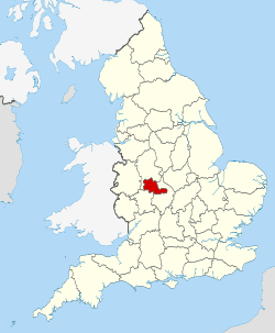 West Midlands in England | |||
| Sovereign state | United Kingdom | ||
| Country | England | ||
| Region | West Midlands | ||
| Established |
1 April 1974 (Local Government Act 1972) | ||
| Ceremonial county | |||
| Area | 902 km2 (348 sq mi) | ||
| • Ranked | 42nd of 48 | ||
| Population (mid-2014 est.) | 2,808,356 | ||
| • Ranked | 2nd of 48 | ||
| Density | 3,039/km2 (7,870/sq mi) | ||
| Ethnicity |
70.1% White (66.0% White British) 18.9% Asian 6.0% Black 3.4% Mixed 1.6% Other[1] | ||
| Metropolitan county | |||
| Government | West Midlands Combined Authority | ||
| Admin HQ | Birmingham | ||
| Area | 902 km2 (348 sq mi) | ||
| ONS code | 2E | ||
| NUTS | UKG3 | ||
| Website |
www | ||
 Districts of West Midlands | |||
| Districts | |||
| Members of Parliament | 28 MPs | ||
| Police | West Midlands Police | ||
| Time zone | GMT (UTC) | ||
| • Summer (DST) | BST (UTC+1) | ||

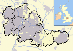
The West Midlands is a metropolitan county in western central England with a 2014 estimated population of 2,808,356,[2] making it the second most populous county in England. It came into existence as a metropolitan county in 1974 after the passage of the Local Government Act 1972, formed from parts of Staffordshire, Worcestershire and Warwickshire. The county itself is a NUTS 2 region within the wider NUTS 1 region of the same name. The county consists of seven metropolitan boroughs: the City of Birmingham, the City of Coventry, and the City of Wolverhampton, as well as Dudley, Sandwell, Solihull, and Walsall.
The metropolitan county exists in law and as a geographic frame of reference.[3][4][5] and as a ceremonial county it has a Lord Lieutenant[6] and a High Sheriff.[7] Between 1974 and 1986, the West Midlands County Council was the administrative body covering the county, this was abolished on 31 March 1986, and the constituent metropolitan boroughs effectively became unitary authorities. A new administrative body for the county; the West Midlands Combined Authority was created in June 2016. There will be a directly elected Mayor of West Midlands from May 2017. Other county-wide bodies include the West Midlands Police, the West Midlands Fire Service and Transport for West Midlands.
The county is sometimes described as the "West Midlands metropolitan area" or the "West Midlands conurbation", although these have different, and less clearly defined, boundaries. The main conurbation, or urban area, does not include Coventry for example. The name "West Midlands" is also used for the much larger West Midlands region, which sometimes causes confusion, not surprising perhaps when geographically it is on the eastern side of the region, the western side comprising Shropshire and Herefordshire.
History
Although the modern county has only existed since 1974, the settlements of the West Midlands have long been important centres of commerce and industry as well as developing a good local infrastructure. Coventry was one of England's most important cities during the Middle Ages, with its prosperity built upon wool and cloth manufacture. Birmingham and Wolverhampton have a tradition of industry dating back to the 16th century, when small metal-working industries developed. Birmingham was known for its manufacture of small arms, whereas Wolverhampton became a centre of lock manufacture and brass working. The coal and iron ore deposits of the Black Country area provided a ready source of raw materials. The area grew rapidly during the Industrial Revolution, and by the 20th century had grown into one large conurbation. Coventry was slower to develop, but by the early 20th century, it had become an important centre of bicycle and car manufacture.
1966 saw a substantial reform in the local government of the area as the patchwork of county boroughs with municipal boroughs and urban district councils in between was replaced by a core of county boroughs covering a contiguous area, roughly as follows:
- Birmingham, which remained substantially unaltered;
- Dudley, which absorbed all of Brierley Hill as well as most of Coseley and Sedgley, and part of Amblecote, Tipton and Rowley Regis;
- Solihull, which remained substantially unaltered;
- Walsall, which absorbed all of Darlaston and most of Willenhall, as well as parts of Wednesbury, Coseley, Wednesfield and Bilston;
- Warley, which was created by amalgamating the vast majority of Smethwick, Oldbury and Rowley Regis as well parts of Dudley, Tipton, West Bromwich and Halesowen;
- West Bromwich, which absorbed most of Wednesbury and Tipton, along with parts of Bilston, Oldbury, Smethwick and Walsall;
- Wolverhampton, which absorbed most of Bilston, Wednesfield and Tettenhall as well as parts of Sedgley, Coseley and Willenhall.
Around the periphery of this area, three other towns remained separate (Halesowen, Stourbridge and Sutton Coldfield), while Aldridge and Brownhills joined to form a single unit, called Aldridge-Brownhills. In the same year, a single West Midlands Constabulary was formed for the Black Country county boroughs, whilst Birmingham retained its Birmingham City Police and Solihull continued being policed by the Warwickshire Constabulary. The West Midlands Passenger Transport Authority was established in 1968.
County Creation
In 1974, the Local Government Act 1972 came into effect, creating the metropolitan county of West Midlands. This area was based on the seven county boroughs and the other non-county boroughs and urban districts around the fringe of the conurbation. The new area consisted of seven new metropolitan boroughs, with Aldridge-Brownhills added to Walsall; Halesowen and Stourbridge to Dudley and Sutton Coldfield to Birmingham. A new borough of Sandwell was formed by the merger of West Bromwich and Warley. The actual designation of Warley itself was abolished and the three towns of Smethwick, Oldbury and Rowley Regis reinstated as component parts of Sandwell, although these areas formed the Warley postal district. Solihull took in much of the suburban fringe to the east of Birmingham, including the former villages of Chelmsley Wood and Castle Bromwich, also Birmingham Airport, and the area of countryside between Solihull and Coventry, whilst Coventry itself received only small changes and Wolverhampton was unaltered. This led to (apart from in the east, with Coventry and the Meriden Gap) quite a tightly defined metropolitan border, excluding such places as Burntwood, Bromsgrove, Cannock, Kidderminster, Lichfield and Wombourne which had been considered for inclusion in the West Midlands metropolitan area by the Redcliffe-Maud Report. The 1974 reform created the West Midlands County Council that covered the entire area and dealt with strategic issues. A new West Midlands Police service was formed covering the entire area, with the West Midlands Constabulary and Birmingham City Police abolished, and also taking over responsibility from the county forces.
| post-1974 | pre-1974 | ||||
|---|---|---|---|---|---|
| Metropolitan county | Metropolitan borough | County boroughs | Non-county boroughs | Urban districts | Rural districts |
 |
Birmingham | Birmingham | Sutton Coldfield | - | - |
| Coventry | Coventry | - | - | Meriden | |
| Dudley | Dudley | Halesowen • Stourbridge • | - | - | |
| Sandwell | Warley • West Bromwich • | - | - | - | |
| Solihull | Solihull | - | - | Meriden • Stratford-on-Avon • | |
| Walsall | Walsall | - | Aldridge-Brownhills | ||
| Wolverhampton | Wolverhampton | - | - | - | |
West Midlands County Council
Between 1974 and 1986, the county had a two-tier system of local government, and the seven districts shared power with the county council. However, the Local Government Act 1985 abolished the county councils, and the West Midlands County Council ceased to exist in 1986. Most of its functions were devolved to the West Midland boroughs, which effectively became unitary authorities, with responsibility for most local authority functions.
Boundary changes
In 1994, the western/southern shores of Chasewater, plus the adjacent Jeffreys Swag, were transferred from the Metropolitan Borough of Walsall to the District of Lichfield, Staffordshire.[8] Further boundary changes came into effect in 1995, when part of the Hereford and Worcester parish of Frankley (including the south-west part of Bartley Reservoir) was transferred to Birmingham and became part of the county.
West Midlands Combined Authority
On 17 June 2016 a new administrative body, the West Midlands Combined Authority was created for the county, under the Local Democracy, Economic Development and Construction Act 2009, which created several other combined authorities in England. The new body has powers over transport, economic development, skills and planning. A new directly elected position of 'metro mayor' will be established in 2017 to chair the new body.[9]
Geography
The West Midlands is a landlocked county that borders the counties of Warwickshire to the east, Worcestershire to the south, and Staffordshire to the north and west.
The West Midlands County is one of the most heavily urbanised counties in the UK. Birmingham, Wolverhampton, the Black Country and Solihull together form the third most populous conurbation in the United Kingdom with a combined population of around 2.44 million.[10] However, the West Midlands is not entirely urban; Coventry is separated from the West Midlands conurbation by a stretch of green belt land roughly 15 miles (24 km) across, known as the "Meriden Gap", which retains a strongly rural character. A smaller piece of green belt between Birmingham, Walsall and West Bromwich includes Barr Beacon and the Sandwell Valley.
The highest point in the West Midlands is Turners Hill, with a height of 271 m (889 ft). The hill is a Site of Special Scientific Interest. Barr Beacon is another hill in the West Midlands, located on the border of Birmingham and Walsall, with a height of 227 m (745 ft).
There are 23 Sites of Special Scientific Interest in the county.[11] One of these SSSIs is Sutton Park in Sutton Coldfield, which has an area of 970 hectares (2,400 acres).[12] As a result, it is one of the largest urban parks in Europe, and the largest outside of a capital city in Europe. The park also has national nature reserve status.
There are numerous rivers that pass through the county, including the River Tame. The river basin is the most urbanised basin in the United Kingdom, with approximately 42% of the basin being urbanised.[13] The River Tame is fed by the River Rea, River Anker, and the River Blythe, which in turn is fed by the River Cole. The River Sowe and River Sherbourne both flow through Coventry. The River Stour flows through the west of the West Midlands county.
Like other metropolitan counties, the West Midlands is divided into districts called metropolitan boroughs. There are seven boroughs in the West Midlands, which are named after the largest settlement in their administrative area. The West Midlands is unusual amongst the metropolitan counties in that three of its boroughs have city status; Coventry is a city by ancient prescriptive usage,[14] Birmingham was granted city status in 1889,[15] and Wolverhampton in 2000 as a "Millennium City".[16]
| Metropolitan borough | Administrative centre | Other towns | |
|---|---|---|---|
| City of Birmingham | |
Birmingham | Edgbaston, Great Barr, Hall Green, Handsworth, Northfield, Quinton, Soho, Sutton Coldfield |
| City of Coventry | |
Coventry | Allesley, Binley, Keresley, Stoke, Tile Hill |
| Dudley | |
Dudley | Brierley Hill, Cradley, Halesowen, Kingswinford, Lye, Netherton, Stourbridge, Quarry Bank |
| Sandwell | |
Oldbury | Bearwood, Rowley Regis, Cradley Heath, Old Hill, Smethwick, Tipton, Tividale, Wednesbury, West Bromwich, Yew Tree |
| Solihull | |
Solihull | Balsall Common, Bickenhill, Castle Bromwich, Chelmsley Wood, Dorridge, Elmdon, Hampton-in-Arden, Kingshurst, Knowle, Marston Green, Meriden, Monkspath, Hockley Heath |
| Walsall | |
Walsall | Aldridge, Bloxwich, Brownhills, Darlaston, Pelsall, Pheasey, Shelfield, Willenhall |
| City of Wolverhampton | |
Wolverhampton | Bilston, Blakenhall, Bushbury, Oxley, Wednesfield |
Governance
The boroughs of the West Midlands effectively work as unitary authorities are responsible for running their own services, however some services are organised on a county-wide level:
- Transport for West Midlands, which is responsible for planning and co-ordinating public transport across the county.
- The West Midlands Police, who are overseen by the West Midlands Police and Crime Commissioner.
- The West Midlands Fire Service, which is administered by a joint Fire and Rescue Authority.
These joint-boards are made up of councillors appointed from each of the seven West Midlands district councils. In addition to this, the West Midlands Joint Committee exists as a joint body of the seven districts to co-ordinate matters such as roads and planning. The seven West Midlands councils jointly produce a county-wide Local Transport Plan.[17] The boroughs also jointly own a share in Birmingham Airport, which used to be owned by the county council.
A combined authority was formed in April 2016 for the West Midlands.[18] The authority absorbed many of the current joint-boards such as the integrated transport authority into one legal authority (while also allowing for a greater level of county-wide collaboration and legal powers), as has happened in the other metropolitan counties. The combined authority will be chaired by a directly-elected mayor, with powers similar to the Mayor of London.[19]
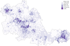
Demography

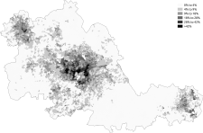
| Distribution of ethnic groups in the West Midlands according to the 2011 census. | ||||||||||||||||||||||||||
|---|---|---|---|---|---|---|---|---|---|---|---|---|---|---|---|---|---|---|---|---|---|---|---|---|---|---|
|


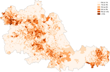
| Distribution of religions in the West Midlands according to the 2011 census. | ||||||||||||||||
|---|---|---|---|---|---|---|---|---|---|---|---|---|---|---|---|---|
|


Places of interest
| Key | |
| | Abbey/Priory/Cathedral |
| | Accessible open space |
| | Amusement/Theme Park |
| | Castle |
| | Country Park |
| | English Heritage |
| | Forestry Commission |
| | Heritage railway |
| | Historic House |
| | Museum (free/not free) |
| | National Trust |
| | Theatre |
| | Zoo |
- Ackers Adventure, Birmingham,

- Aston Hall, Birmingham

- Bantock House Museum and Park, Wolverhampton
- Bescot Stadium (Walsall F.C.)
- Bilston Craft Gallery, Wolverhampton

- Birmingham Botanical Gardens

- Birmingham Bullring
- Birmingham Museum & Art Gallery
- Birmingham Hippodrome

- Black Country Living Museum, Dudley
.svg.png)
- Blakesley Hall, Birmingham
- Cadbury World, Bournville, Birmingham
- Coventry Cathedral

- Coventry SkyDome Arena
- Coventry Transport Museum
- Dudley Castle

- Dudley Zoo

- Edgbaston Cricket Ground, Birmingham
- International Convention Centre (including Symphony Hall), Birmingham
- Merry Hill Shopping Centre, Dudley
- Molineux Stadium (Wolverhampton Wanderers F.C.)
- Moseley Old Hall, Wolverhampton

- National Exhibition Centre
- National Indoor Arena (NIA), Birmingham
- Sea Life Centre, Birmingham
- Netherton Tunnel, Dudley
- The New Art Gallery Walsall, Walsall
- Perrott's Folly, Birmingham
- Red House Glass Cone, Stourbridge
- Ricoh Arena (Coventry City Football Club)
- Sandwell Valley Country Park, West Bromwich

- Sarehole Mill, Birmingham
- St Andrew's (Birmingham City Football Club)
- St Peter's Collegiate Church, Wolverhampton
- The Hawthorns (West Bromwich Albion Football Club)
- Thinktank Millennium Point, Birmingham
- Tyseley Locomotive Works, Birmingham

- University of Birmingham
- Villa Park (Aston Villa Football Club)
- Walsall Art Gallery
- West Park, Wolverhampton
- Wightwick Manor, Wolverhampton
- Winterbourne Botanic Garden, Birmingham
- Wolverhampton Art Gallery, Wolverhampton
- Wolverhampton Civic Hall, Wolverhampton
- Wolverhampton Grand Theatre, Wolverhampton
- Wolverhampton Racecourse, Wolverhampton
Education
The West Midlands contains ten universities, seven of which are located in Birmingham:
- Aston University
- University of Birmingham
- Birmingham City University
- University College Birmingham
- BPP University
- University of Law
- Newman University
Both Coventry University and the University of Warwick are located in Coventry whilst University of Wolverhampton is located in Wolverhampton with campuses in Telford and Walsall.
Each of the local authorities has at least one further education college for students aged over 16, and since September 1992 all of the local authorities have operated traditional 5-7 infant, 7-11 junior, and 11-16/18 secondary schools for students in compulsory education. This followed the demise of 5-8 first, 8-12 middle and 12-16/18 secondary schools in the Sutton Coldfield area.[20]
For 18 years before September 1990, Dudley had operated 5-8 first, 8-12 middle, and 12-16/18 secondary schools before then, while Halesowen (September 1972 until July 1982) and Aldridge-Brownhills (September 1972 until July 1986) had both operated 5-9 first, 9-13 middle and 13-16/18 secondary schools.
Many local authorities still have sixth form facilities in secondary schools, though sixth form facilities had been axed by most secondary schools in Dudley since the early 1990s (and in Halesowen in 1982) as the local authorities changed direction towards further education colleges.
All secondary state education in Dudley and Sandwell is mixed comprehensive, although there are a small number of single sex and grammar schools existing in parts of Birmingham, Solihull, Wolverhampton and Walsall.
In August 2009, Matthew Boulton College and Sutton Coldfield College merged to become Birmingham Metropolitan College, one of the largest further and higher education institutions in the country. Plans are afoot for the construction of a new campus in the Perry Barr area of Birmingham.
Sport
Football
The West Midlands is home to numerous sports teams. In football, there are six Premier League and Football League teams in the county of which one, West Bromwich Albion, plays in the Barclays Premier League. Aston Villa, Birmingham City, Coventry City, Walsall, West Bromwich Albion and Wolverhampton Wanderers are often referred to as the West Midlands "Big Six".
| Club | League | City/town | Stadium | Capacity |
|---|---|---|---|---|
| Aston Villa | Championship | Birmingham | Villa Park | 42,788 |
| West Bromwich Albion | Premier League | West Bromwich | The Hawthorns | 26,500 |
| Birmingham City | Championship | Birmingham | St Andrew's | 30,079 |
| Wolverhampton Wanderers | Championship | Wolverhampton | Molineux | 31,700 |
| Coventry City | League One | Coventry | Ricoh Arena | 32,609 |
| Walsall | League One | Walsall | Bescot Stadium | 11,300 |
Other sports
In rugby union, the West Midlands is home to Wasps RFC, Sutton Coldfield RFC, Spartans RFC, Moseley Rugby Football Club, Birmingham & Solihull RFC, Dudley Kingswinford RFC, Wolverhampton RFC Walsall RFC and Coventry RFC.
The West Midlands is also home to Warwickshire County Cricket Club, who are based at Edgbaston Cricket Ground, which also hosts Test matches and One Day Internationals. The Birmingham Panthers basketball team replaced the Birmingham Bullets and are currently based at a facility provided by the University of Wolverhampton in Walsall.
See also
- List of ceremonial counties in England by gross value added
- List of conservation areas in the West Midlands
- Evolution of Worcestershire county boundaries
References
- ↑ "2011 Census: Key Statistics for Local Authorities in England and Wales". ONS. Retrieved 26 December 2012.
- ↑ "2014 UK Population Estimates". ONS. Retrieved 27 July 2015.
- ↑ Office for National Statistics - Gazetteer of the old and new geographies of the United Kingdom, p48. URL accessed 10 March 2007.
- ↑ Metropolitan Counties and Districts, Beginners' Guide to UK Geography, Office for National Statistics, 17 September 2004. URL accessed 10 March 2007.
- ↑ West Midlands Counties, The Boundary Commission for England. URL accessed 10 March 2007.
- ↑ "West Midlands Lieutenancy". The West Midlands Lieutenancy. Retrieved 24 November 2013.
- ↑ "West Midlands 2013/2014". High Sheriff's Association of England and Wales (The Shrievalty Association). Retrieved 24 November 2013.
- ↑ "The Hereford and Worcester, Staffordshire and West Midlands (County and Metropolitan Borough Boundaries) Order 1993". Office of Public Sector Information. 20 September 2000. Retrieved 20 January 2008.
- ↑ "All systems go for West Midlands Combined Authority as MPs say 'Yes'". The Chamberlain Files. Retrieved 23 June 2016.
- ↑ "2011 Census - Built-up areas". ONS. Retrieved 27 July 2013.
- ↑ "SSSIs in the West Midlands". Natural England. Retrieved 2 February 2008.
- ↑ Introduction To Sutton Park Birmingham City Council
- ↑ John S. Rowan; R. W. Duck; A. Werritty (2006). Sediment Dynamics and the Hydromorphology of Fluvial Systems. IAHS. p. 98. ISBN 1-901502-68-6.
- ↑ Home Office List of English Cities by Ancient Prescriptive Right, 1927, cited in Beckett, J V (2005). City status in the British Isles, 1830–2002. Aldershot: Ashgate. p. 12. ISBN 0-7546-5067-7.
- ↑ "History of Mayoralty". Birmingham.gov.uk. Archived from the original on 10 May 2008. Retrieved 17 May 2008.
- ↑ "City winners named". BBC News. 18 December 2000. Retrieved 17 May 2008.
- ↑ "What is the LTP?". West Midlands Local Transport Plan. Retrieved 24 March 2008.
- ↑ http://www.localgov.co.uk/Councils-reveal-West-Midlands-combined-authority-plan/37573
- ↑ "Birmingham agrees elected mayor for 2017". birminghampost. Retrieved 2015-11-18.
- ↑ Sutton Coldfield
External links
| Wikimedia Commons has media related to West Midlands. |
- Photographs of Birmingham and the West Midlands
- Identity in the West Midlands
- West Midlands Joint Committee
- Images of West Midlands at the English Heritage Archive
- West Midlands (county) at DMOZ
Districts of the West Midlands Region | ||
|---|---|---|
| Herefordshire | 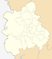 | |
| Shropshire | ||
| Staffordshire | ||
| Warwickshire | ||
| West Midlands | ||
| Worcestershire | ||
Coordinates: 52°30′N 1°50′W / 52.500°N 1.833°W