A62 road
| |
|---|---|
|
Click map to enlarge | |
|
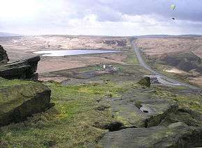
Standedge seen from the top of nearby Pule Hill. The A62 cutting and Redbrook Reservoir can be seen | |
| Route information | |
| Length: | 39.46 mi[1] (63.50 km) |
| Major junctions | |
| West end: |
53°29′06″N 2°13′58″W / 53.4849°N 2.2327°W Manchester |
| East end: |
53°47′16″N 1°34′15″W / 53.7878°N 1.5709°W Leeds |
| Location | |
| Primary destinations: |
Oldham Huddersfield |
| Road network | |

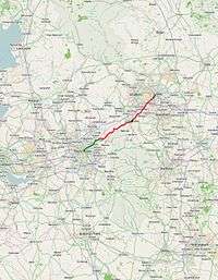
The A62 is a major road in Northern England that runs between the two major cities of Manchester and Leeds, covering a distance of 38.5 miles (62.0 km).
Route
The A62 runs north east from the Manchester Inner Ring Road (beginning as Oldham Street and Oldham Road) through Failsworth and Oldham then Saddleworth before crossing the Pennines at Standedge into West Yorkshire. Continuing through Marsden, Slaithwaite, Linthwaite, Huddersfield, Liversedge, Heckmondwike and Birstall. It terminates just short of Leeds city centre at its junction with the A58 road. It has primary status from Manchester as far as Oldham.
History
It is paralleled by part of the M62 Trans-Pennine motorway. Prior to the building of the M62, the A62 was the main trans-Pennine road between Oldham and Huddersfield. The M62 is numbered after the A62 and now takes most of the long-distance traffic between Manchester and Leeds.
References
- ↑ "Directions to Gelderd Rd/A62". Google Maps. Google. Retrieved 4 May 2013.
External links
A roads in Zone 6 of the Great Britain road numbering scheme | ||
|---|---|---|