Yountville, California
| Town of Yountville | |
|---|---|
| Town | |
|
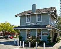
Center of Yountville | |
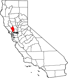
 Location in Napa County and the state of California | |
| Coordinates: 38°24′11″N 122°21′44″W / 38.40306°N 122.36222°WCoordinates: 38°24′11″N 122°21′44″W / 38.40306°N 122.36222°W | |
| Country |
|
| State |
|
| County | Napa |
| Incorporated | February 4, 1965[1] |
| Area[2] | |
| • Total | 1.531 sq mi (3.966 km2) |
| • Land | 1.531 sq mi (3.966 km2) |
| • Water | 0 sq mi (0 km2) 0% |
| Elevation | 98 ft (30 m) |
| Population (2010) | |
| • Total | 2,933 |
| • Density | 1,900/sq mi (740/km2) |
| Time zone | Pacific (PST) (UTC-8) |
| • Summer (DST) | PDT (UTC-7) |
| ZIP code | 94599 |
| Area code(s) | 707 |
| FIPS code | 06-86930 |
| GNIS feature ID | 1652660 |
| Website | Official website |

Yountville (/ˈjɔːntvɪl/ or /ˈjaʊntvɪl/) is an incorporated town in Napa County, California, United States. It is in the North Bay portion of the San Francisco Bay Area. The population was 2,933 at the 2010 census. Almost one third of the town's population lives on the grounds of the Veterans Home of California.
The town's name is derived from the name of early pioneer George Calvert Yount. Yount was considered responsible for establishing the first vineyard in the Napa Valley.
Yountville is a noted destination for gourmet diners, and has two Michelin starred restaurants, The French Laundry and Bouchon Bistro.
History
Yountville was named after George C. Yount in 1867. Previously the town was named Sebastopol in 1855. However, a town in nearby Sonoma County had already laid claim to this name, so the town was renamed after George Yount’s death.
Restaurants
Among the restaurants in Yountville is the French Laundry, owned by Chef Thomas Keller, with a three star rating from the Michelin Guide, and a two-time winner of the title "best restaurant in the world" by "The Worlds 50 Best" restaurant rating organization. Keller also owns another restaurant in Yountville, Ad Hoc. Michelin one-star restaurants in Yountville for 2015 also include Bouchon, another Thomas Keller Restaurant . Two other Yountville restaurants have Michelin's "Bib Gourmand" rating, Philippe Jeanty's Bistro Jeanty and Redd Wood.
Gourmet dining in Yountville dates to 1977, when Philippe Jeanty opened the restaurant at Domaine Chandon, owned by French champagne house Moët & Chandon.
Despite claims to the contrary, as of 2012, Yountville does not have the most Michelin Stars per capita.[3]
Economy
Major employers in Yountville include the Veterans Home of California The Vintage Estate, Domaine Chandon California and Newton Vineyard.[4]
Geography
According to the United States Census Bureau, the town has a total area of 1.5 sq mi (4.0 km2)), all of it land.
Yountville suffered a 5.2 magnitude earthquake on September 3, 2000.[5]
| Climate data for Yountville, California | |||||||||||||
|---|---|---|---|---|---|---|---|---|---|---|---|---|---|
| Month | Jan | Feb | Mar | Apr | May | Jun | Jul | Aug | Sep | Oct | Nov | Dec | Year |
| Average high °F (°C) | 56 (13) |
62 (17) |
65 (18) |
70 (21) |
76 (24) |
83 (28) |
87 (31) |
87 (31) |
85 (29) |
77 (25) |
65 (18) |
56 (13) |
72.4 (22.3) |
| Average low °F (°C) | 38 (3) |
40 (4) |
42 (6) |
43 (6) |
47 (8) |
51 (11) |
53 (12) |
52 (11) |
51 (11) |
47 (8) |
42 (6) |
38 (3) |
45.3 (7.4) |
| Average precipitation inches (mm) | 6.02 (152.9) |
6.15 (156.2) |
4.39 (111.5) |
1.78 (45.2) |
1.06 (26.9) |
.19 (4.8) |
0 (0) |
.09 (2.3) |
.24 (6.1) |
1.64 (41.7) |
3.86 (98) |
6.21 (157.7) |
31.63 (803.3) |
| Source: [6] | |||||||||||||
Demographics
| Historical population | |||
|---|---|---|---|
| Census | Pop. | %± | |
| 1880 | 256 | — | |
| 1890 | 231 | −9.8% | |
| 1970 | 2,332 | — | |
| 1980 | 2,893 | 24.1% | |
| 1990 | 3,259 | 12.7% | |
| 2000 | 2,916 | −10.5% | |
| 2010 | 2,933 | 0.6% | |
| Est. 2015 | 3,017 | [7] | 2.9% |

2010
The 2010 United States Census[9] reported that Yountville had a population of 2,933. The population density was 1,915.3 people per square mile (739.5/km²). The racial makeup of Yountville was 2,623 (89.4%) White, 38 (1.3%) African American, 30 (1.0%) Native American, 49 (1.7%) Asian, 0 (0.0%) Pacific Islander, 92 (3.1%) from other races, and 101 (3.4%) from two or more races. Hispanic or Latino of any race were 289 persons (9.9%).
The Census reported that 1,945 people (66.3% of the population) lived in households, 60 (2.0%) lived in non-institutionalized group quarters, and 928 (31.6%) were institutionalized.
There were 1,050 households, out of which 136 (13.0%) had children under the age of 18 living in them, 418 (39.8%) were opposite-sex married couples living together, 64 (6.1%) had a female householder with no husband present, 16 (1.5%) had a male householder with no wife present. There were 48 (4.6%) unmarried opposite-sex partnerships, and 16 (1.5%) same-sex married couples or partnerships. 449 households (42.8%) were made up of individuals and 257 (24.5%) had someone living alone who was 65 years of age or older. The average household size was 1.85. There were 498 families (47.4% of all households); the average family size was 2.53.
The population was spread out with 237 people (8.1%) under the age of 18, 75 people (2.6%) aged 18 to 24, 426 people (14.5%) aged 25 to 44, 767 people (26.2%) aged 45 to 64, and 1,428 people (48.7%) who were 65 years of age or older. The median age was 64.0 years. For every 100 females there were 136.3 males. For every 100 females age 18 and over, there were 139.2 males.
There were 1,252 housing units at an average density of 817.6 per square mile (315.7/km²), of which 688 (65.5%) were owner-occupied, and 362 (34.5%) were occupied by renters. The homeowner vacancy rate was 4.2%; the rental vacancy rate was 5.2%. 1,266 people (43.2% of the population) lived in owner-occupied housing units and 679 people (23.2%) lived in rental housing units.
2000
As of the census[10] of 2000, there were 2,916 people, 1,048 households, and 553 families residing in the town. The population density was 1,790.8 people per square mile (690.7/km²). There were 1,133 housing units at an average density of 695.8 per square mile (268.4/km²).
There were 1,048 households out of which 17.8% had children under the age of 18 living with them, 42.0% were married couples living together, 7.4% had a female householder with no husband present, and 47.2% were non-families. 39.8% of all households were made up of individuals and 17.5% had someone living alone who was 65 years of age or older. The average household size was 1.95 and the average family size was 2.59.
In the town the population was spread out with 11.1% under the age of 18, 2.4% from 18 to 24, 17.5% from 25 to 44, 23.8% from 45 to 64, and 45.1% who were 65 years of age or older. The median age was 60 years. For every 100 females there were 126.2 males. For every 100 females age 18 and over, there were 128.1 males.
The median income for a household in the town was $46,944, and the median income for a family was $56,250. Males had a median income of $46,853 versus $34,464 for females. The per capita income for the town was $30,721. About 5.6% of families and 7.3% of the population were below the poverty line, including 13.3% of those under age 18 and 6.9% of those age 65 or over.
Government
The Town of Yountville has a council-manager form of government.[11] The Town Council consists of: Mayor John F. Dunbar (elected November 2014; term expires November 2018), Vice Mayor Richard Hall (term expires November 2018), Council Member Marjorie "Margie" Mohler (term expires November 2016), Council Member Jeffrey Durham (term expires November 2016) and Council Member Marita Dorenbecher (term expires November 2018).[12] The Town Manager is Steven Rogers.[11]
State and federal representation
In the California State Legislature, Yountville is in the 3rd Senate District, represented by Democrat Bill Dodd, and in the 4th Assembly District, represented by Democrat Cecilia Aguiar-Curry.[13]
In the United States House of Representatives, Yountville is in California's 5th congressional district, represented by Democrat Mike Thompson.[14]
Other attractions

- Bespoke Collection
- Napa Valley Museum
- Lincoln Theatre
- The Yountville American Viticultural Area
- The comfort food restaurant, Ad Hoc (also owned by Thomas Keller)
- Veterans Memorial Grove Cemetery (also known as the California State Veterans Home Cemetery)[15]
- George C. Yount Pioneer Cemetery
- Vine Trail Bike Path
See also
References
- ↑ "California Cities by Incorporation Date" (Word). California Association of Local Agency Formation Commissions. Retrieved August 25, 2014.
- ↑ "2010 Census U.S. Gazetteer Files – Places – California". United States Census Bureau.
- ↑ Satran, Joe (17 August 2011). "The 20 Most Michelin-Starred Cities In The World (PHOTOS)". Huffington Post. Retrieved 6 January 2016.
- ↑ Private-sector employers -- Napa County
- ↑ USGS report
- ↑ "Monthly Averages for Yountville, CA (94599)". The Weather Channel. Retrieved March 10, 2012.
- ↑ "Annual Estimates of the Resident Population for Incorporated Places: April 1, 2010 to July 1, 2015". Retrieved July 2, 2016.
- ↑ "Census of Population and Housing". Census.gov. Archived from the original on May 11, 2015. Retrieved June 4, 2015.
- ↑ "2010 Census Interactive Population Search: CA - Yountville city". U.S. Census Bureau. Retrieved July 12, 2014.
- ↑ "American FactFinder". United States Census Bureau. Retrieved 2008-01-31.
- 1 2 "Town Manager's Office". Town of Yountville. Retrieved 29 March 2016.
- ↑ "Mayor and Council Members". Town of Yountville. Retrieved 29 March 2016.
- ↑ "Statewide Database". UC Regents. Retrieved December 6, 2014.
- ↑ "California's 5th Congressional District - Representatives & District Map". Civic Impulse, LLC. Retrieved March 3, 2013.
- ↑ Veterans Home Cemetery
External links
| Wikimedia Commons has media related to Yountville, California. |
| Wikivoyage has a travel guide for Yountville. |
 |
Windsor | Oakville | Winters | |
| Rohnert Park | |
Dixon | ||
| ||||
| | ||||
| Novato | Napa American Canyon |
Vacaville |
| Bodies of water |
|  |
|---|---|---|
| Counties | ||
| Major cities | ||
| Cities and towns 100k–250k | ||
| Cities and towns 50k–99k | ||
| Cities and towns 25k-50k | ||
| Cities and towns 10k–25k |
| |
| Sub-regions | ||