St. Helena, California
| City of St. Helena Anakotanoma | ||||||||
|---|---|---|---|---|---|---|---|---|
| General law city[1] | ||||||||
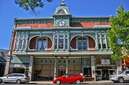
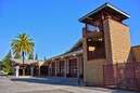
Clockwise from top: the business district, the former train station, the Richie Block building, St. Helena High School, the fire station, and the post office. | ||||||||
| Motto: "Napa Valley's Main Street",[2] "The Heart Of Napa Valley" | ||||||||
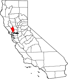
 Location in Napa County and the state of California | ||||||||
| Coordinates: 38°30′19″N 122°28′13″W / 38.50528°N 122.47028°W | ||||||||
| Country | United States | |||||||
| State | California | |||||||
| County | Napa | |||||||
| Incorporated | March 24, 1876[3] | |||||||
| Re-incorporated | May 14, 1889[4] | |||||||
| Government | ||||||||
| • Type | Council-City Manager[1] | |||||||
| • Mayor | Alan Galbraith[5] | |||||||
| • Vice mayor | Peter White[5] | |||||||
| • City manager | Jennifer Phillips[6] | |||||||
| Area[7] | ||||||||
| • City | 5.027 sq mi (13.019 km2) | |||||||
| • Land | 4.986 sq mi (12.913 km2) | |||||||
| • Water | 0.041 sq mi (0.106 km2) 0.81% | |||||||
| Elevation[8] | 253 ft (77 m) | |||||||
| Population (April 1, 2010)[9] | ||||||||
| • City | 5,814 | |||||||
| • Estimate (2013)[9] | 5,947 | |||||||
| • Density | 1,200/sq mi (450/km2) | |||||||
| • Metro | 136,484 | |||||||
| Time zone | Pacific (UTC-8) | |||||||
| • Summer (DST) | PDT (UTC-7) | |||||||
| ZIP code | 94574 | |||||||
| Area code | 707 | |||||||
| FIPS code | 06-64140 | |||||||
| GNIS feature IDs | 277588, 2411758 | |||||||
| Website |
www | |||||||


St. Helena (/ˌseɪnt hᵻˈliːnə/ saint hə-LEE-nə) (Wappo: Anakotanoma, "Bull Snake Village")[10] is a city in Napa County, California. It is part of the North Bay region of the San Francisco Bay Area. The population was 5,814 at the 2010 census.
The city's American Viticultural Area includes 416 vineyards encompassing 6,800 acres (2,800 ha) of planted vineyards. St. Helena is also the location of The Culinary Institute of America at Greystone and a campus of Napa Valley College.
History
Ellen White, co-founder of the Seventh-day Adventist Church, had a home called "Elmshaven" near St. Helena, beginning in 1900. She died there in 1915 and the site is now a National Historic Landmark. Both the Beringer Vineyards and the Charles Krug Winery are California Historical Landmarks.[11]
St. Helena's community center was built as a Carnegie library; it served as the city library from 1908 to 1978.[12]
Geography
St. Helena has a total area of 5.03 sq mi (13.0 km2), of which 4.99 sq mi (12.9 km2) is land and 0.11 sq mi (0.3 km2) (0.81%) is water.
Climate
The National Weather Service has a cooperative weather station in St. Helena. Winters are cool and wet, while summers have hot days and cool nights with little precipitation. Average temperatures in December, the coldest month, range from 57 °F (14 °C) to 38 °F (3 °C). Average temperatures in July and August, the warmest months, range from 89 °F (32 °C) to 55 °F (13 °C). There are an average of 55.7 days with highs of 90 °F (32 °C) or higher and an average of 34.7 days with lows of 32 °F (0 °C) or lower. The record high temperature was 115 °F (46 °C) on July 13, 1972, and the record low temperature was 11 °F (−12 °C) on December 11, 1932.
Average annual precipitation is 36.64 inches (931 mm). There are an average of 68 days with measurable precipitation. The wettest year was 1983 with 75.40 inches (1,915 mm) and the driest year was 1976 with 10.41 inches (264 mm). The wettest month on record was February 1986 with 25.60 inches (650 mm). The most rainfall in 24 hours was 6.83 inches (173 mm) on January 21, 1967. Although snow rarely falls in St. Helena, there is an annual average snowfall of 0.2-inch (5.1 mm). The most snowfall in one month was 4.0 inches (100 mm), recorded in January 1974 and again in March 1976. The most snowfall in 24 hours was 4.0 inches (100 mm) on March 2, 1976.[13]
| Climate data for St. Helena (1907–2012) | |||||||||||||
|---|---|---|---|---|---|---|---|---|---|---|---|---|---|
| Month | Jan | Feb | Mar | Apr | May | Jun | Jul | Aug | Sep | Oct | Nov | Dec | Year |
| Record high °F (°C) | 83 (28) |
86 (30) |
95 (35) |
98 (37) |
107 (42) |
110 (43) |
115 (46) |
112 (44) |
113 (45) |
104 (40) |
93 (34) |
83 (28) |
115 (46) |
| Average high °F (°C) | 56.6 (13.7) |
61.1 (16.2) |
65.4 (18.6) |
71.5 (21.9) |
78.1 (25.6) |
85.0 (29.4) |
89.7 (32.1) |
88.9 (31.6) |
85.9 (29.9) |
77.3 (25.2) |
66.2 (19) |
57.6 (14.2) |
73.6 (23.1) |
| Average low °F (°C) | 36.4 (2.4) |
38.9 (3.8) |
40.3 (4.6) |
42.7 (5.9) |
46.7 (8.2) |
50.4 (10.2) |
52.1 (11.2) |
51.4 (10.8) |
49.1 (9.5) |
45.4 (7.4) |
40.3 (4.6) |
36.7 (2.6) |
44.2 (6.8) |
| Record low °F (°C) | 16 (−9) |
21 (−6) |
24 (−4) |
27 (−3) |
31 (−1) |
36 (2) |
37 (3) |
38 (3) |
33 (1) |
23 (−5) |
23 (−5) |
11 (−12) |
11 (−12) |
| Average precipitation inches (mm) | 7.60 (193) |
6.53 (165.9) |
4.32 (109.7) |
2.10 (53.3) |
.85 (21.6) |
.25 (6.4) |
.03 (0.8) |
.07 (1.8) |
.29 (7.4) |
1.72 (43.7) |
3.93 (99.8) |
6.90 (175.3) |
34.59 (878.7) |
| Average precipitation days (≥ .01 in) | 12 | 11 | 9 | 6 | 4 | 1 | 0 | 1 | 1 | 4 | 8 | 11 | 66 |
| Average rainy days (≥ .1 in) | 9 | 8 | 7 | 4 | 2 | 1 | 0 | 0 | 1 | 3 | 5 | 8 | 47 |
| Source: Western Regional Climate Center[14] | |||||||||||||
Demographics
| Historical population | |||
|---|---|---|---|
| Census | Pop. | %± | |
| 1880 | 1,339 | — | |
| 1890 | 1,705 | 27.3% | |
| 1900 | 1,582 | −7.2% | |
| 1910 | 1,603 | 1.3% | |
| 1920 | 1,346 | −16.0% | |
| 1930 | 1,582 | 17.5% | |
| 1940 | 1,758 | 11.1% | |
| 1950 | 2,297 | 30.7% | |
| 1960 | 2,722 | 18.5% | |
| 1970 | 3,173 | 16.6% | |
| 1980 | 4,898 | 54.4% | |
| 1990 | 4,990 | 1.9% | |
| 2000 | 5,950 | 19.2% | |
| 2010 | 5,814 | −2.3% | |
| Est. 2015 | 6,088 | [15] | 4.7% |
The 2010 United States Census[17] reported that St. Helena had a population of 5,814. The population density was 1,156.7 people per square mile (446.6/km²). The racial makeup of St. Helena was 4,525 (77.8%) White, 25 (0.4%) African American, 35 (0.6%) Native American, 98 (1.7%) Asian, 9 (0.2%) Pacific Islander, 978 (16.8%) from other races, and 144 (2.5%) from two or more races. Hispanic or Latino of any race were 1,914 persons (32.9%).
The Census reported that 98.3% of the population lived in households and 1.7% lived in non-institutionalized group quarters.
There were 2,401 households, out of which 694 (28.9%) had children under the age of 18 living in them, 1,118 (46.6%) were opposite-sex married couples living together, 223 (9.3%) had a female householder with no husband present, 99 (4.1%) had a male householder with no wife present. There were 96 (4.0%) unmarried opposite-sex partnerships, and 20 (0.8%) same-sex married couples or partnerships. 805 households (33.5%) were made up of individuals and 411 (17.1%) had someone living alone who was 65 years of age or older. The average household size was 2.38. There were 1,440 families (60.0% of all households); the average family size was 3.03.
The population was spread out with 1,280 people (22.0%) under the age of 18, 453 people (7.8%) aged 18 to 24, 1,333 people (22.9%) aged 25 to 44, 1,627 people (28.0%) aged 45 to 64, and 1,121 people (19.3%) who were 65 years of age or older. The median age was 42.9 years. For every 100 females there were 88.2 males. For every 100 females age 18 and over, there were 84.9 males.
There were 2,776 housing units at an average density of 552.3 per square mile (213.2/km²), of which 55.4% were owner-occupied and 44.6% were occupied by renters. The homeowner vacancy rate was 2.7%; the rental vacancy rate was 5.8%. 51.4% of the population lived in owner-occupied housing units and 46.9% lived in rental housing units.
Government
St. Helena is a general law city which lacks its own charter. It operates under a council-manager form of government.[1] In the California State Legislature, St. Helena is in the 3rd Senate District, represented by Democrat Bill Dodd,[18] and in the 4th Assembly District, represented by Democrat Cecilia Aguiar-Curry.[19] In the United States House of Representatives, St. Helena is in California's 5th congressional district, represented by Democrat Mike Thompson.[20]
Education
St. Helena High School serves students in grades 9-12, and the city has two secondary campuses, one is the Upper Valley Campus of Napa Valley College; the other is The Culinary Institute of America at Greystone, a branch campus of the main institution in Hyde Park, New York.
Economy
Major employers in St. Helena include St. Helena Hospital, Trinchero Family Estates, Meadowood Napa Valley, Icon Estates, and The Culinary Institute of America.[21] The city is distinct in its regulation against chain restaurants; only one exists in the city, established before the legislation was enacted.[22] The St. Helena AVA is in the region, and numerous wineries exist within St. Helena.
Notable people
Those who live or lived in St. Helena include winemakers Nicole Abiouness, Amy Aiken, Cathy Corison, David Duncan, Charles Krug, and Josephine Tychson, the first woman to build and operate a winery in the U.S. state of California. Others include Rico Abreu, a stock car racing driver, Michela Alioto-Pier, a former member of the San Francisco Board of Supervisors, baseball players Wayne Belardi, Fred Hofmann, and Billy Orr, M. F. K. Fisher, a food writer, William Hamilton, a cartoonist and playwright who spent his childhood in St. Helena,[23] Siegfried Horn, an archaeologist and bible scholar, William B. Hurlbut, Bob Marshall, businessman Fritz Maytag, Congressman Donald C. McRuer, Charles O'Rear, a photographer, Carl Osburn, a Navy officer and sports shooter, Frank K. Richardson, associate justice of the California Supreme court, Dave Smith, an engineer and musician, Edwin R. Thiele, a missionary, writer, and archaeologist, Mike Thompson, U.S. Representative for California's 5th congressional district (who was born and lives in St. Helena), Owen Wade, a politician, and Ellen G. White, an author and pioneer.
In popular culture
- An episode of My Ghost Story was filmed at a winery in the city.
See also
- List of cities and towns in California
- List of cities and towns in the San Francisco Bay Area
- Tree City USA
References
- 1 2 3 "About St. Helena". City of St. Helena. Retrieved January 23, 2015.
- ↑ "St. Helena Chamber of Commerce". Retrieved January 23, 2015.
- ↑ "California Cities by Incorporation Date" (Word). California Association of Local Agency Formation Commissions. Retrieved August 25, 2014.
- ↑ "About St. Helena". City of St. Helena. Retrieved December 20, 2014.
- 1 2 "City Council". City of St. Helena. Retrieved January 23, 2015.
- ↑ "Administration". City of St. Helena. Retrieved September 19, 2014.
- ↑ "2010 Census U.S. Gazetteer Files – Places – California". United States Census Bureau.
- ↑ "Saint Helena". Geographic Names Information System. United States Geological Survey. Retrieved February 25, 2015.
- 1 2 "St. Helena (city) QuickFacts". United States Census Bureau. Retrieved February 25, 2015.
- ↑ "Wappo Language". Wappo Indians of Napa County. Retrieved 2012-08-15.
- ↑ "California Historical Landmarks: Napa County". Office of Historical Preservation, California State Parks. Retrieved September 6, 2014.
- ↑ "Carnegie Libraries of California". Pat & Bernie Skehan. Retrieved December 20, 2014.
- ↑ Western Regional Climate Center website
- ↑ http://www.wrcc.dri.edu/cgi-bin/cliMAIN.pl?ca7643
- ↑ "Annual Estimates of the Resident Population for Incorporated Places: April 1, 2010 to July 1, 2015". Retrieved July 2, 2016.
- ↑ "Census of Population and Housing". Census.gov. Retrieved June 4, 2015.
- ↑ "2010 Census Interactive Population Search: CA - St. Helena city". U.S. Census Bureau. Retrieved July 12, 2014.
- ↑ "Senators". State of California. Retrieved August 25, 2014.
- ↑ "Members Assembly". State of California. Retrieved 25 August 2014.
- ↑ "California's 5th Congressional District - Representatives & District Map". Civic Impulse, LLC. Retrieved March 3, 2013.
- ↑ Private-sector employers -- Napa County
- ↑ "St. Helena Municipal Code". Code Publishing. City of St. Helena. February 11, 2014. Retrieved September 14, 2014.
- ↑ Parties with the Upper One Percent Provide the Pith and Vinegar for Bill Hamilton's Cartoons Retrieved February 12, 2015
External links
| Wikimedia Commons has media related to St. Helena, California. |
| Wikivoyage has a travel guide for St. Helena (California). |
| Bodies of water |
|  |
|---|---|---|
| Counties | ||
| Major cities | ||
| Cities and towns 100k–250k | ||
| Cities and towns 50k–99k | ||
| Cities and towns 25k-50k | ||
| Cities and towns 10k–25k |
| |
| Sub-regions | ||
 |
Calistoga | Clearlake | Angwin | |
| Santa Rosa | |
Winters | ||
| ||||
| | ||||
| Rohnert Park | Rutherford | Dixon |