Carquinez Strait
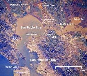
The Carquinez Strait is a narrow tidal strait in northern California. It is part of the tidal estuary of the Sacramento and the San Joaquin rivers as they drain into the San Francisco Bay. The strait connects Suisun Bay, which receives the waters of the combined rivers, with San Pablo Bay, a northern extension of the San Francisco Bay.
Location
The strait forms part of the border between Solano (to the north) and Contra Costa (to the south) counties, and is approximately 15 mi (25 km) north of Oakland. The cities of Benicia and Vallejo lie on the north side of the strait, while Martinez, Port Costa, and Crockett sit on the southern coast. The Napa River joins the strait, via the short Mare Island Strait, near its entrance into San Pablo Bay.
Name
The strait is named after the Karkin ("los Carquines" in Spanish), a linguistic division of the Ohlone Native Americans who resided on both sides of the strait.[1]
Installations
The California Maritime Academy is at the western end of the strait on the northern waterfront. The C&H Sugar refinery is located on the southern shore in the small town of Crockett.
Bridges
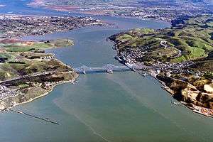
The strait is crossed by two highway bridges, the Carquinez Bridge on Interstate 80 and the Benicia-Martinez Bridge on Interstate 680. Each highway bridge consists of two spans.
Interstate 780 connects the two highways on the northern slope of the strait. State Route 4 connects these highways south of and inland from the strait.
A rail bridge just east of the Benicia-Martinez bridge is used by the Capitol Corridor, California Zephyr, and Coast Starlight trains. A rail ferry, with the ferries Contra Costa and Solano provided service across the strait near the location of the current rail bridge until the rail bridge was built in 1930.
Tall pylons carrying power lines cross the strait as well. The Carquinez Strait Powerline Crossing was the world's first powerline crossing of a large river.
Ship traffic
The channel is navigable and is used for commercial and military shipping. Deep water ship traffic bound for both the Port of Sacramento and the Port of Stockton traverse the strait.
Formation of Delta
The narrow gap in the Coast Range that forms the strait has led to the formation of the San Joaquin-Sacramento River Delta, an inverted river delta, upstream of it, a rare geological feature. The strait is too small to allow the passage of huge amounts of floodwaters created during years with heavy rainfall/snowmelt events. Because the Delta area is the first to fill and last to drain in a flood event, silt and soil have more time to drop out of suspension, creating the inverted river delta feature.
References
- ↑ Coffey, Geoffrey (2004-07-28). "Going in for natural solitude on Mt. Wanda". The San Francisco Chronicle. Retrieved 2008-04-08.
| Bodies of water |
|  |
|---|---|---|
| Counties | ||
| Major cities | ||
| Cities and towns 100k–250k | ||
| Cities and towns 50k–99k | ||
| Cities and towns 25k-50k | ||
| Cities and towns 10k–25k |
| |
| Sub-regions | ||
Coordinates: 38°03′33″N 122°12′45″W / 38.05918°N 122.21260°W