Wraxall, Dorset
| Wraxall | |
 Church of St Mary, Lower Wraxall |
|
 Wraxall |
|
| Population | 40 [1] |
|---|---|
| OS grid reference | ST572012 |
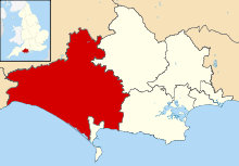
| District | West Dorset |
| Shire county | Dorset |
| Region | South West |
| Country | England |
| Sovereign state | United Kingdom |
| Police | Dorset |
| Fire | Dorset and Wiltshire |
| Ambulance | South Western |
| EU Parliament | South West England |
Coordinates: 50°48′20″N 2°36′21″W / 50.8056°N 2.6059°W
Wraxall is a civil parish in the English county of Dorset, consisting of the two hamlets Higher Wraxall and Lower Wraxall. It is situated in a valley in the chalk hills of the Dorset Downs, about 11 miles (18 km) north-west of the county town Dorchester. Dorset County Council's 2013 mid-year estimate of the parish population is 40.[1]
The origin of the name Wraxall, shared with several other villages in Somerset, Wiltshire and Dorset, is thought to be "a nook of land frequented by buzzards".[2]
St Mary's Church is the most noticeable building in the parish.
References
- 1 2 "Parish Population Data". Dorset County Council. 20 January 2015. Retrieved 21 March 2015.
- ↑ Bristol & Avon Family History Society
External links
![]() Media related to Wraxall, Dorset at Wikimedia Commons
Media related to Wraxall, Dorset at Wikimedia Commons
This article is issued from Wikipedia - version of the 9/30/2016. The text is available under the Creative Commons Attribution/Share Alike but additional terms may apply for the media files.