Folke
| Folke | |
 Folke Manor House |
|
 Folke |
|
| Population | 270 [1] |
|---|---|
| OS grid reference | ST660135 |
| District | West Dorset |
| Shire county | Dorset |
| Region | South West |
| Country | England |
| Sovereign state | United Kingdom |
| Police | Dorset |
| Fire | Dorset and Wiltshire |
| Ambulance | South Western |
| EU Parliament | South West England |
Coordinates: 50°55′11″N 2°29′11″W / 50.9196°N 2.4864°W
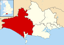
Folke is a parish in the county of Dorset in southern England, situated in the Blackmore Vale in the West Dorset administrative district approximately 3.5 miles (5.6 km) south-east of Sherborne. The parish has an area of 2,120 acres (8.6 km2) and includes the hamlet of Folke itself and the slightly larger settlement of Alweston. Dorset County Council's 2013 estimate of the population of Folke parish is 270.[1] In the 2011 census figures have been published for the population of Folke parish combined with the small parish of North Wootton to the north; this was 339.[2] The Manor House in the hamlet of Folke dates from about 1500, and adjoins the early 17th-century parish church.[3] The house of Font le Roi, sited by the road towards Sturminster Newton, was built as a gatehouse in the 15th century.[3] Folke Wood is nearby.
References
- 1 2 "Parish Population Data". Dorset County Council. 20 January 2015. Retrieved 28 February 2015.
- ↑ "Area: Folke (Parish), Key Figures for 2011 Census: Key Statistics". Neighbourhood Statistics. Office for National Statistics. Retrieved 28 January 2014.
- 1 2 West Dorset, Holiday and Tourist Guide. West Dorset District Council. c. 1983. p. 9.
External links
![]() Media related to Folke at Wikimedia Commons
Media related to Folke at Wikimedia Commons