Shire of Denmark
This article is about a local government area. For the town, see Denmark, Western Australia.
| Shire of Denmark Western Australia | |||||||||||||
|---|---|---|---|---|---|---|---|---|---|---|---|---|---|
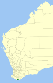 Location in Western Australia | |||||||||||||
| Population | 5,748 (2013 est)[1] | ||||||||||||
| • Density | 3.0902/km2 (8.0035/sq mi) | ||||||||||||
| Established | 1911 | ||||||||||||
| Area | 1,860.1 km2 (718.2 sq mi) | ||||||||||||
| Mayor | David Morrell | ||||||||||||
| Council seat | Denmark | ||||||||||||
| Region | Great Southern | ||||||||||||
| State electorate(s) | Blackwood-Stirling | ||||||||||||
| Federal Division(s) | O'Connor | ||||||||||||
|
| |||||||||||||
| Website | Shire of Denmark | ||||||||||||
| |||||||||||||
The Shire of Denmark is a local government area in the Great Southern region[2] of Western Australia, about 55 kilometres (34 mi) west of Albany and about 420 kilometres (261 mi) south-southeast of the state capital, Perth. The Shire of Denmark covers an area of 1,860 square kilometres (718 sq mi), and its seat of government is located in the townsite and locality of Denmark.
History
The Denmark Road District was gazetted in 1911. On 1 July 1961, the district became a shire following the passing of the Local Government Act 1960.[3]
Wards
The Shire of Denmark is divided into three wards with a varying number of councillors:[4]
- Scotsdale/Shadforth Ward (four councillors)
- Town Ward (three councillors)
- Kent/Nornalup Ward (two councillors)
Townsites
- Denmark (extended to include residential portions of Ocean Beach on 5 July 2016)
- Nornalup (created on 5 July 2016)
- Peaceful Bay (created on 5 July 2016)
Localities
- Bow Bridge
- Denmark
- Hay
- Hazelvale
- Kentdale
- Kordabup
- Mount Lindesay
- Mount Romance
- Nornalup
- Ocean Beach
- Parryville
- Peaceful Bay
- Scotsdale
- Shadforth
- Tingledale
- Trent
- William Bay
References
- ↑ "3218.0 Regional Population Growth, Australia. Table 5. Estimated Resident Population, Local Government Areas, Western Australia". 3 April 2014. Retrieved 11 September 2014.
- ↑ This region is defined in the Regional Development Commissions Act 1993
- ↑ WA Electoral Commission, Municipality Boundary Amendments Register (release 2.0), 31 May 2003.
- ↑ http://www.denmark.wa.gov.au/our-council/councillor-contact-details.aspx
External links
Coordinates: 34°57′36″S 117°21′11″E / 34.960°S 117.353°E
This article is issued from Wikipedia - version of the 10/26/2016. The text is available under the Creative Commons Attribution/Share Alike but additional terms may apply for the media files.