| [2] |
Name on the Register |
Image |
Date listed[3] |
Location |
City or town |
Description |
|---|
| 1 |
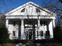
Buckman Tavern |
|
000000001966-10-15-0000October 15, 1966
(#66000137) |
Hancock St., on the eastern side of Lexington Green
42°26′57″N 71°13′49″W / 42.449167°N 71.230278°W / 42.449167; -71.230278 (Buckman Tavern) |
Lexington |
National Historic Landmark
|
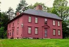
| 2 |
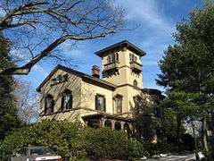
Gen. Samuel Chandler House |
|
000000001977-04-13-0000April 13, 1977
(#77000176) |
8 Goodwin Rd.
42°27′04″N 71°13′45″W / 42.451111°N 71.229167°W / 42.451111; -71.229167 (Gen. Samuel Chandler House) |
Lexington |
|
| 3 |
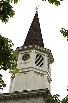
Follen Community Church |
|
000000001976-04-30-0000April 30, 1976
(#76000242) |
755 Massachusetts Ave.
42°25′47″N 71°12′27″W / 42.429722°N 71.2075°W / 42.429722; -71.2075 (Follen Community Church) |
Lexington |
|
| 4 |
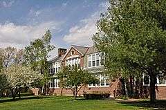
Franklin School |
|
000000002009-09-25-0000September 25, 2009
(#09000437) |
7 Stedman Rd.
42°25′41″N 71°13′46″W / 42.427922°N 71.229367°W / 42.427922; -71.229367 (Franklin School) |
Lexington |
|
| 5 |
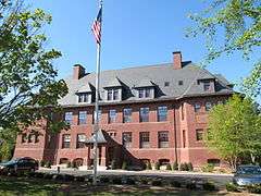
Hancock School |
|
000000001975-08-22-0000August 22, 1975
(#75000261) |
33 Forest St.
42°26′50″N 71°13′56″W / 42.447222°N 71.232222°W / 42.447222; -71.232222 (Hancock School) |
Lexington |
|
| 6 |
Hancock-Clarke House |
|
000000001971-07-17-0000July 17, 1971
(#71000895) |
36 Hancock St.
42°27′13″N 71°13′43″W / 42.453556°N 71.228556°W / 42.453556; -71.228556 (Hancock-Clarke House) |
Lexington |
National Historic Landmark
|
| 7 |
Lexington Green |
|
000000001966-10-15-0000October 15, 1966
(#66000767) |
Massachusetts and Hancock Sts.
42°26′58″N 71°13′53″W / 42.449444°N 71.231389°W / 42.449444; -71.231389 (Lexington Green) |
Lexington |
National Historic Landmark
|
| 8 |
John Mason House |
|
000000001990-03-09-0000March 9, 1990
(#90000172) |
1303 Massachusetts Ave.
42°26′28″N 71°12′54″W / 42.441111°N 71.215°W / 42.441111; -71.215 (John Mason House) |
Lexington |
|
| 9 |
M.H. Merriam and Company |
|
000000002009-02-18-0000February 18, 2009
(#09000033) |
7–9 Oakland St.
42°26′56″N 71°13′37″W / 42.448906°N 71.227033°W / 42.448906; -71.227033 (M.H. Merriam and Company) |
Lexington |
|
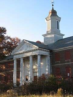
| 10 |
Metropolitan State Hospital |
|
000000001994-01-21-0000January 21, 1994
(#93001482) |
475 Trapelo Rd.
42°24′14″N 71°12′40″W / 42.403889°N 71.211111°W / 42.403889; -71.211111 (Metropolitan State Hospital) |
Lexington |
Extends into Belmont and Waltham
|
| 11 |
Peacock Farm Historic District |
|
000000002012-11-21-0000November 21, 2012
(#12000949) |
1-6 Compton Cir., 1-5 Mason St., 2-53 Peacock Farm Rd., 4-17 Trotting Horse Dr.
42°25′15″N 71°12′13″W / 42.4208°N 71.2035°W / 42.4208; -71.2035 (Peacock Farm Historic District) |
Lexington |
|
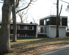
| 12 |
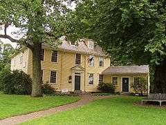
Sanderson House and Munroe Tavern |
|
000000001976-04-26-0000April 26, 1976
(#76000248) |
1314 and 1332 Massachusetts Ave.
42°26′30″N 71°13′00″W / 42.441667°N 71.216667°W / 42.441667; -71.216667 (Sanderson House and Munroe Tavern) |
Lexington |
|
| 13 |
Warren E. Sherburne House |
|
000000001977-12-02-0000December 2, 1977
(#77000178) |
11 Percy Rd.
42°26′32″N 71°13′13″W / 42.442222°N 71.220278°W / 42.442222; -71.220278 (Warren E. Sherburne House) |
Lexington |
|
| 14 |
Simonds Tavern |
|
000000001976-10-14-0000October 14, 1976
(#76000251) |
331 Bedford St.
42°28′03″N 71°14′36″W / 42.4675°N 71.243333°W / 42.4675; -71.243333 (Simonds Tavern) |
Lexington |
|
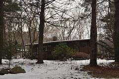
| 15 |
Six Moon Hill Historic District |
|
000000002016-01-19-0000January 19, 2016
(#15000981) |
4, 8 Bird Hill & 1-40 Moon Hill Rds, 16, 24 Swan Ln.
42°25′23″N 71°12′42″W / 42.423055°N 71.211536°W / 42.423055; -71.211536 (Six Moon Hill Historic District) |
Lexington |
|
| 16 |
Stone Building |
|
000000001976-04-30-0000April 30, 1976
(#76000252) |
735 Massachusetts Ave.
42°25′46″N 71°12′26″W / 42.429444°N 71.207222°W / 42.429444; -71.207222 (Stone Building) |
Lexington |
|
| 17 |
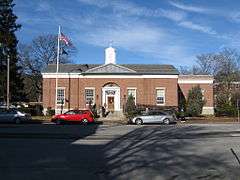
US Post Office-Lexington Main |
|
000000001986-06-26-0000June 26, 1986
(#86001377) |
1661 Massachusetts Ave.
42°26′49″N 71°13′32″W / 42.446944°N 71.225556°W / 42.446944; -71.225556 (US Post Office-Lexington Main) |
Lexington |
|


.jpg)