| [2] |
Name on the Register[3] |
Image |
Date listed[4] |
Location |
City or town |
Description |
|---|
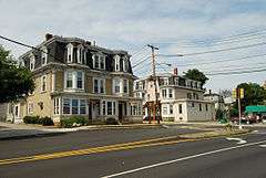
| 1 |
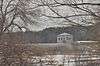
Concord Square Historic District |
|
000000001983-03-10-0000March 10, 1983
(#83000794) |
Park, Concord, and Kendall Sts., and Union Ave.
42°16′42″N 71°25′06″W / 42.2783°N 71.4183°W / 42.2783; -71.4183 (Concord Square Historic District) |
Framingham |
|
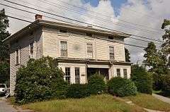
| 2 |
Moses Ellis House |
|
000000001983-11-29-0000November 29, 1983
(#83004022) |
283 Pleasant St.
42°18′16″N 71°26′58″W / 42.3044°N 71.4494°W / 42.3044; -71.4494 (Moses Ellis House) |
Framingham |
|
| 3 |
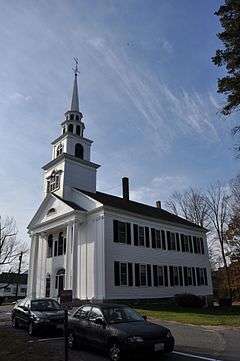
First Baptist Church |
|
000000001980-04-09-0000April 9, 1980
(#80000642) |
1013 Worcester Rd.
42°18′01″N 71°26′20″W / 42.3003°N 71.4389°W / 42.3003; -71.4389 (First Baptist Church) |
Framingham |
|
| 4 |
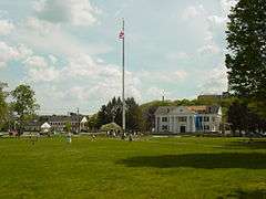
Framingham Centre Common Historic District |
|
000000001990-10-25-0000October 25, 1990
(#90001564) |
Roughly centered on Framingham Centre Common, between MA 9 and Interstate 90
42°18′13″N 71°26′08″W / 42.3036°N 71.4356°W / 42.3036; -71.4356 (Framingham Centre Common Historic District) |
Framingham |
|
| 5 |
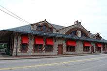
Framingham Railroad Station |
|
000000001975-01-17-0000January 17, 1975
(#75000258) |
417 Waverly St.
42°16′35″N 71°25′06″W / 42.2764°N 71.4183°W / 42.2764; -71.4183 (Framingham Railroad Station) |
Framingham |
|
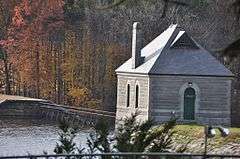
| 6 |
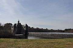
Framingham Reservoir No. 1 Dam and Gatehouse |
|
000000001990-01-18-0000January 18, 1990
(#89002291) |
Eastern end of Framingham Reservoir No. 1, off Winter St. north of Long Ave.
42°17′30″N 71°26′34″W / 42.2917°N 71.4428°W / 42.2917; -71.4428 (Framingham Reservoir No. 1 Dam and Gatehouse) |
Framingham |
|
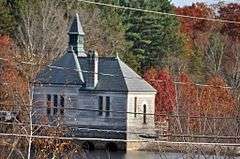
| 7 |
Framingham Reservoir No. 2 Dam and Gatehouse |
|
000000001990-01-18-0000January 18, 1990
(#89002290) |
Between Framingham Reservoirs Nos. 1 and 2, west of the junction of Winter and Fountain Sts.
42°16′58″N 71°26′45″W / 42.2828°N 71.4458°W / 42.2828; -71.4458 (Framingham Reservoir No. 2 Dam and Gatehouse) |
Framingham |
|
| 8 |
Framingham Reservoir No. 3 Dam and Gatehouse |
|
000000001990-01-18-0000January 18, 1990
(#89002261) |
Southeastern end of Framingham Reservoir No. 3, off MA 9/30
42°17′38″N 71°27′36″W / 42.2939°N 71.46°W / 42.2939; -71.46 (Framingham Reservoir No. 3 Dam and Gatehouse) |
Framingham |
|
| 9 |
Paul Gibbs House |
|
000000001983-03-10-0000March 10, 1983
(#83000804) |
1147 Edmands Rd.
42°19′49″N 71°28′52″W / 42.3303°N 71.4811°W / 42.3303; -71.4811 (Paul Gibbs House) |
Framingham |
|
| 10 |
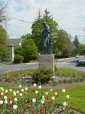
Irving Square Historic District |
|
000000001982-11-30-0000November 30, 1982
(#82000491) |
Irving Square, Waverly, South, Columbia, Irving, Gordon and Hollis Sts.
42°16′32″N 71°25′01″W / 42.2756°N 71.4169°W / 42.2756; -71.4169 (Irving Square Historic District) |
Framingham |
|
| 11 |
Lake Cochituate Dam |
|
000000001990-01-18-0000January 18, 1990
(#89002250) |
Northwestern side of Lake Cochituate
42°18′54″N 71°23′05″W / 42.315°N 71.3847°W / 42.315; -71.3847 (Lake Cochituate Dam) |
Framingham |
|
| 12 |
Saint John's Episcopal Church |
|
000000001990-01-12-0000January 12, 1990
(#89002300) |
Maynard Rd. and Church St.
42°17′50″N 71°26′21″W / 42.2972°N 71.4392°W / 42.2972; -71.4392 (Saint John's Episcopal Church) |
Framingham |
Now the Ecumenical Center at Framingham State University.
|
| 13 |
Saxonville Historic District |
|
000000001992-08-20-0000August 20, 1992
(#92000992) |
Roughly along Elm, Danforth, Central, Water and Concord Sts.
42°19′29″N 71°24′04″W / 42.3247°N 71.4011°W / 42.3247; -71.4011 (Saxonville Historic District) |
Framingham |
|
| 14 |
Sudbury Aqueduct Linear District |
|
000000001990-01-18-0000January 18, 1990
(#89002293) |
Along Sudbury Aqueduct from Farm Pond at Waverly St. (Framingham) to Chestnut Hill Reservoir (Newton)
42°17′33″N 71°18′44″W / 42.2925°N 71.3122°W / 42.2925; -71.3122 (Sudbury Aqueduct Linear District) |
Framingham |
Extends into Wellesley and Needham in Norfolk County, and Sherborn, Natick and Newton in Middlesex County.
|
| 15 |
Sudbury Dam Historic District |
|
000000001990-01-18-0000January 18, 1990
(#89002265) |
Southeastern end of Sudbury Reservoir off MA 30
42°18′21″N 71°29′30″W / 42.3058°N 71.4917°W / 42.3058; -71.4917 (Sudbury Dam Historic District) |
Framingham |
Extends into Southborough, Worcester County.
|
| 16 |
Weston Aqueduct Linear District |
|
000000001990-01-18-0000January 18, 1990
(#89002274) |
Along the Weston Aqueduct from the Sudbury Reservoir to the Weston Reservoir
42°20′00″N 71°22′32″W / 42.3333°N 71.3756°W / 42.3333; -71.3756 (Weston Aqueduct Linear District) |
Framingham |
Extends into Southborough, Worcester County, and Weston and Wayland in Middlesex County.
|
| 17 |
Whit's Diner |
|
000000002003-12-04-0000December 4, 2003
(#03001243) |
184A Fountain St.
42°16′31″N 71°26′02″W / 42.2753°N 71.4339°W / 42.2753; -71.4339 (Whit's Diner) |
Framingham |
|