Majd al-Krum
Majd al-Krum
| |
|---|---|
| Hebrew transcription(s) | |
| • Also spelled | Majd al-Kurum (official) |
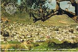 Majd al-Krum in the 1970s | |
 Majd al-Krum Majd al-Krum in the 1970s | |
| Coordinates: 32°55′17″N 35°15′25″E / 32.92139°N 35.25694°ECoordinates: 32°55′17″N 35°15′25″E / 32.92139°N 35.25694°E | |
| Grid position | 173/258 PAL |
| District | Northern |
| Government | |
| • Type | Local council (from 1964) |
| Area | |
| • Total | 5,400 dunams (5.4 km2 or 2.1 sq mi) |
| Population (2015)[1] | |
| • Total | 14,774 |
| Name meaning | "Watch-house of the vineyard"[2] |
Majd al-Krum (Arabic: مجد الكروم, Hebrew: מַגְ'ד אל-כֻּרוּם Majd al-Kurum) is an Arab town located in the Upper Galilee in Israel's Northern District about 16 kilometers (10 miles) east of Acre. The name of the village translates to "watch-house of the vineyard",[2] reflecting the town's fame for the quality of its grape vines.[3] The town is entirely inhabited by Muslims. In 2015 it had a population of 14,774.
History
Majd al-Krum is an ancient site in the plain at the foot of Jabal Mahüz. Ancient remains, including cisterns dug into the rock, have been found.[4] In the center of Majd al-Krum, there is an ancient well, a spring, a Roman-era tomb and ruins dating to the Crusader period.[5]
The name comes from the "watch-house of the vineyard" in Arabic.[2] Majd al-Kurum receives its name for its history of growing grapes. Ancient ruins (located on the outskirts of the town), consisting of pits built into the rocks where the residents used their feet to press their grape crop to make wine. According to the Jewish Encyclopedia the town is identified with "Beit HaKerem", a Jewish Talmudic town. It's Hebrew name means the same as its Arabic name.[6]
During the Crusader era, Majd al-Krum was known as Mergelcolon. It was part of Stephanie of Milly's inheritance.[7] Stephanie was the maternal grandmother of John Aleman, and in 1249 he transferred land, including Beit Jann, Sajur, Nahf and Majd al-Krum to the Teutonic Knights.[8]
Ottoman era
Incorporated into the Ottoman Empire in 1517 with all of Palestine, Majd al-Krum appeared in the 1596 Ottoman tax registers as being in the Nahiya of Akka of the Liwa of Safad. It had a population of 85 households and five bachelors, all Muslim, and paid taxes on wheat, barley, olives or fruit trees, cotton, and goats and/or beehives.[9] A map from Napoleon's invasion of 1799 by Pierre Jacotin showed the place, named as El Megd El Kouroum.[10]
In 1875 the French explorer Victor Guérin visited and described Majd al-Krum as being divided into three quarters, each with a different Sheikh. The total population was 800 Muslims,[11] while in 1881, the Palestine Exploration Fund's Survey of Western Palestine described it as a village built of stone and surrounded by olive trees and arable land, inhabited by 600–800 Muslims.[12]
British Mandatory period

In the 1922 census of Palestine conducted by the British Mandate authorities, Majd al-Krum had a population of 889, of which 885 were Sunni Muslim, three Shia Muslims and one Christian.[13] In the 1931 census, Majd al-Krum had 226 occupied houses and a population of 1,006 Muslims.[14] By 1945, Majd al-Kurum had 1,400 inhabitants, all classified as Arabs. They owned a total of 17,828 dunams of land, while 2214 dunams were public property.[15]
During the 1936–1939 Arab revolt against British Mandatory rule and increased Jewish settlement in Palestine, Majd al-Krum was one of the first villages in the Galilee to participate in the revolt with a resident, Abu Faris, claiming he was the first individual to take up arms in the Galilee during the revolt and the first to have his house demolished by the British as punishment for his participation. Abu Faris became the second-in-command of the revolt in Galilee until 1938 when he refused an order to assassinate a Palestinian Arab supporter of the Peel Commission partition plan for Palestine into Jewish and Arab states. Abu Faris later left Palestine for Lebanon after a major political leader of the revolt, Amin al-Husayni, ordered his assassination.[16]
1948 War and aftermath

Majd al-Krum was captured by Israeli forces in October 1948 during Operation Hiram. A unit of the Arab Liberation Army (ALA) that had been stationed there withdrew from the village upon the Israelis' approach. As he was departing, the ALA's Iraqi commander assembled the inhabitants around the village well and suggested that they not flee the village, but rather stay and surrender to Israeli officers that they knew. Accordingly, a group of Majd al-Krum's residents contacted Haim Auerbach, an Israeli intelligence officer based in Nahariya (who a group of villagers had previously defended from an attack near Acre.) Auerbach arranged for Majd al-Krum's surrender and pledged no harm would come to the village.[17]
However, on 6 November, an Israeli Army unit, unaware of the village's surrender, entered the village and confronted the other Israeli unit already present in the village. The two sides realized their mistake after a brief exchange of fire, and the latter unit was replaced by the incoming unit. The new unit ordered the residents to hand over their weapons within 30 minutes despite having already surrendered their arms a week prior. Before the deadline was reached, the commanding Israeli officer ordered the demolition of a home and gathered five residents, blindfolded them and executed them by gunfire to demonstrate their seriousness. They gathered another five residents to execute, but were stopped by a known Palestinian Arab informant from al-Damun, Shafiq Buqa'i. Buqa'i requested the Israeli officers free the residents by explaining to them the earlier agreement made between the villagers and Auerbach.[17]
During the 1948 War, the village of Sha'ab was largely depopulated and most of its residents settled in Majd al-Krum, some permanently and others temporarily.[18] Many people who fled Majd al-Krum settled in the Shatila refugee camp in Lebanon.[19] A former fighter from the village, Abed Bishr, leased a small plot of land outside Beirut and founded the Shatila refugee camp and gathered other refugees from Majd al-Krum to settle there. According to historian Julie Peteet, the role of Majd al-Krum and its refugees "was foundational in its [the camp's] establishment."[20]
Contemporary period
Prior to the 1948 war, Majd al-Krum's land area consisted of 20,065 dunams (20.07 hectares), 69% of which was confiscated by the Israeli state between 1948 and the mid-1970s.[21] The majority of the land was confiscated on the basis of the 1949 Absentees' Property Law from refugees who fled during the war, while the remainder confiscated for "public purposes" or on the basis of lacking formal title (communal land as designated by Ottoman-era land laws).[21]
Jurisdiction over confiscated lands subsequently came under the Israel Land Authority (ILA), which, because of a 1960 law prohibiting the sale of state lands, began a process of land exchange with Majd al-Krum's remaining inhabitants.[22] Accordingly, many residents of Majd al-Krum exchanged agricultural land they owned for confiscated land within the village proper, i.e. areas designated for residential use, in lieu of purchasing lands confiscated from the village.[22] The typical exchange rate entailed the residents' transfer of five dunams of their agricultural lands for one dunam of land within the residential areas of the village, and the ILA would normally keep a 10–25% ownership stake in the residential parcel.[22] The ILA minority ownership stake was not explicitly marked in surveys, thus guaranteeing the ILA control over the residents' right to build on their newly-acquired parcels.[22] The process of land exchange was particularly active between 1965 and 1980, during which 15,860 dunams were transferred to the ILA in exchange for 3,010 dunams transferred to Majd al-Krum's residents.[23]
Majd al-Krum was made a local council in 1964.[24] Concurrently, about 5,100 dunams of land were expropriated by the state for the construction of the Jewish town of Karmiel, whose establishment was declared as an effort to Judaize the Galilee by Israeli Prime Minister Levi Eshkol.[25] In 1966, efforts for a master plan began and were completed in 1978. However, the master plan was not approved by the authorities and while the population grew from 4,000 to 6,700 between 1966 and 1990, no new land was allocated to Majd al-Krum to cope with population growth.[26] Beginning in the 1970s, the Jewish Agency launched efforts to build around sixty small Jewish communities, then known as mitzpim (observation points), in between Arab villages in the Galilee to monitor and check Arab building activity.[25] Among these Jewish communities were Lavon, Tuval, Gilon and Tzurit, which all border Majd al-Krum.[25]
Several hundred residents of Majd al-Krum took part in the Land Day demonstrations of 1976, which protested another round of the state's expropriation of Arab-owned land, in which 2,100 dunams from Majd al-Krum were transferred to expand Karmiel.[27] Six Arab protesters were killed in nearby Arab towns and since then, mass expropriation of Arab-owned land by the state has virtually ended.[27] In 1977, large anti-government demonstrations were held in Majd al-Krum and nearby villages to protest the demolition of a house in Majd al-Krum built near the road between Safed and Acre. One person was killed and several others injured as police attempted to disperse protesters. The incident prompted mayor Muhammad Manna to leave the Labor Party and join Hadash. Manna was subsequently reelected in 1986.[28] Tawfiq Ziad, a member of the Knesset, declared "as long as there are stones in the Galilee, we shall use them to stone those who try to destroy our homes."[29] The protest and the response of the state led to more assertive opposition by Israel's Arab community toward state policies.[28]
In 2003 Majd al-Krum and the nearby local councils of Deir al-Asad and Bi'ina merged to form the city of Shaghur.[24] During the 2006 Lebanon War, over 40 Katyusha rockets landed in the vicinity of Shaghur, with the nearby city of Karmiel being the apparent target. Two men from Majd al-Krum, Baha' Karim and Muhammad Subhi Mana', were killed when a rocket struck near them.[30] Shaghur was later dissolved in 2009.[31]
Notable residents
- Adel Manna, historian and writer
References
- ↑ "List of localities, in Alphabetical order" (PDF). Israel Central Bureau of Statistics. Retrieved 16 October 2016.
- 1 2 3 Palmer, 1881, p. 52
- ↑ Asser, Martin. Inside a Palestinian refugee camp. BBC News. 2008-05-17.
- ↑ Dauphin, 1998, p. 662
- ↑ Jacobs, p. 240.
- ↑ בקעת בית כרם [Beit-Kerem Valley]. Jewish Encyclopedia Daat (in Hebrew). Herzog College.
- ↑ RHC Lois II, 1843, p. 454; cited in Frankel, 1988, p. 253.
- ↑ Strehlke, 1869, pp. 78–79, No. 100; cited in Röhricht, 1893, RHH, p.308, No. 1175; cited in Frankel, 1988, p. 254.
- ↑ Hütteroth and Abdulfattah, 1977, p. 191
- ↑ Karmon, 1960, p. 166.
- ↑ Guérin, 1880, pp. 437-438, 444
- ↑ Conder and Kitchener, 1881, SWP I, p. 150.
- ↑ Barron, 1923, Table XI, Sub-district of Acre, p. 36
- ↑ Mills, 1932, p. 101
- ↑ Government of Palestine, Department of Statistics. Village Statistics, April, 1945. Quoted in Hadawi, 1970, p. 40
- ↑ Swedenburg, 2003, pp. 164–165.
- 1 2 Cohen, 2010, pp. 105–106.
- ↑ Cohen, 2010, p. 100.
- ↑ Peteet, 2011, pp. 113-114.
- ↑ Peteet, 2011, p. 114.
- 1 2 Yiftachel 1995, p. 140.
- 1 2 3 4 Yiftachel 1995, p. 141.
- ↑ Yiftachel 1995, p. 142.
- 1 2 Gutterman, Dov. Local Council of Majd el-Kurum (Israel). Flags of the World.
- 1 2 3 Yiftachel, pp. 142–143.
- ↑ McDowall, p. 138.
- 1 2 Yiftachel, p. 152.
- 1 2 Reiter, p. 79.
- ↑ Reiter, p. 82.
- ↑ Civilians under assault, Case Studies: Karmiel, Majd al-Kurum and Deir al-Assad Human Rights Watch. August 2007.
- ↑ Table 1 - Population of Localities Numbering Above 2,500 Residents. Israel Central Bureau of Statistics (ICBS). 2009.
Bibliography
| Wikimedia Commons has media related to Majd al-Krum. |
- Auguste-Arthur, Comte de Beugnot, ed. (1843). RHC Lois II (in French and Latin). Paris: R.H.C.
- Barron, J. B., ed. (1923). Palestine: Report and General Abstracts of the Census of 1922. Government of Palestine.
- Cohen, Hillel (2010). Good Arabs: The Israeli Security Agencies and the Israeli Arabs, 1948-1967. University of California Press. ISBN 9780520944886.
- Conder, Claude Reignier; Kitchener, Herbert H. (1881). The Survey of Western Palestine: Memoirs of the Topography, Orography, Hydrography, and Archaeology. 1. London: Committee of the Palestine Exploration Fund.
- Dauphin, Claudine (1998). La Palestine byzantine, Peuplement et Populations. BAR International Series 726 (in French). III : Catalogue. Oxford: Archeopress.
- Frankel, Rafael (1988). "Topographical notes on the territory of Acre in the Crusader period". Israel Exploration Journal. 38 (4): 249–272.
- Guérin, Victor (1880). Description Géographique Historique et Archéologique de la Palestine (in French). 3: Galilee, pt. 1. Paris: L'Imprimerie Nationale.
- Hadawi, Sami (1970). Village Statistics of 1945: A Classification of Land and Area ownership in Palestine. Palestine Liberation Organization Research Center.
- Hütteroth, Wolf-Dieter; Abdulfattah, Kamal (1977). Historical Geography of Palestine, Transjordan and Southern Syria in the Late 16th Century. Erlanger Geographische Arbeiten, Sonderband 5. Erlangen, Germany: Vorstand der Fränkischen Geographischen Gesellschaft. ISBN 3-920405-41-2.
- Karmon, Y. (1960). "An Analysis of Jacotin's Map of Palestine" (PDF). Israel Exploration Journal. 10 (3,4): 155–173; 244–253.
- Mills, E., ed. (1932). Census of Palestine 1931. Population of Villages, Towns and Administrative Areas. Jerusalem: Government of Palestine.
- Palmer, E. H. (1881). The Survey of Western Palestine: Arabic and English Name Lists Collected During the Survey by Lieutenants Conder and Kitchener, R. E. Transliterated and Explained by E.H. Palmer. Committee of the Palestine Exploration Fund.
- Peteet, Julie (2011). Landscape of Hope and Despair: Palestinian Refugee Camps. University of Pennsylvania Press. ISBN 9780812200317.
- Röhricht, Reinhold (1893). (RRH) Regesta regni Hierosolymitani (MXCVII-MCCXCI) (in Latin). Berlin: Libraria Academica Wageriana.
- Strehlke, Ernst, ed. (1869). Tabulae Ordinis Theutonici ex tabularii regii Berolinensis codice potissimum. Berlin: Weidmanns.
- Swedenburg, Ted (2003). Memories of Revolt: The 1936–1939 Rebellion and the Palestinian National Past. University of Arkansas Press. ISBN 1610752635.
- Yiftachel, Oren (1995). "The Planning of Majd el Krum: The Practice of Control". Progress in Planning. 44 (2): 139–158. doi:10.1016/0305-9006(95)90165-5. ISSN 0305-9006.
External links
- Welcome To Majd al-Kurum
- Survey of Western Palestine, Map 3: IAA, Wikimedia commons