Baqa al-Gharbiyye
Baqa al-Gharbiyye
| ||
|---|---|---|
| Hebrew transcription(s) | ||
| • Also spelled | Baqa al-Gharbiya (unofficial) | |
 | ||
| ||
 Baqa al-Gharbiyye | ||
| Coordinates: 32°25′13.18″N 35°02′31.85″E / 32.4203278°N 35.0421806°ECoordinates: 32°25′13.18″N 35°02′31.85″E / 32.4203278°N 35.0421806°E | ||
| Grid position | 154/202 PAL | |
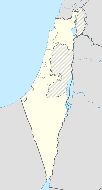
| District | Haifa | |
| Government | ||
| • Type | City (from 1264) | |
| • Mayor | Morsey abo mokh | |
| Area | ||
| • Total | 9,100 dunams (9.1 km2 or 3.5 sq mi) | |
| Population (2015)[1] | ||
| • Total | 28,125 | |
| Name meaning | The western bouquet (of flowers) or "The western Baka"[2] | |


Baqa al-Gharbiyye (Arabic: باقة الغربية, Hebrew: באקה אל-גרביה, בָּקַה אל-עַ'רְבִּיָּה; lit. Baqa West) is a predominantly Arab city in the Haifa District of Israel, located near the Green Line. In 2003, Baqa al-Gharbiyye united with the Jatt local council to form Baqa-Jatt, a unification that was dissolved a few years later. The city had a population of 28,125 in 2015.
History
Roman, Byzantine and Umayyad eras
An olive press, quarries and a winepress seeming to date to the Hellenistic or Early Roman period has been found.[3] Ceramic objects from the late Roman or early Byzantine periods have also been found,[4] and a burial cave, with remains dating to Byzantine and the beginning of the Umayyad periods (sixth–seventh centuries CE).[5]
Middle Ages
The earliest documentation regarding Baqa is from the 12th century. In 1265 Baibars divided the village of Baqa between Alam al-Din al-Zahiry and Aladdin al-Tankazy when the villages of Palestine were divided and given to the local fighters who fought against the Crusaders and the Byzantines.
Ottoman era
Baqa was mentioned in an Ottoman document in 1538, as a five-family small village with 11 non-married people. In 1596, Baqa al-Gharbiyye appeared in Ottoman tax registers as being in the Nahiya of Jabal Shami of the Liwa of Nablus. It had a population of 5 Muslim households and paid taxes on wheat, barley, summercrops, goats or beehives, and a press for olives or grapes.[6]
During the late Ottoman period, in 1870, the French explorer Victor Guérin visited the village. He described it as standing on a low hill. A few wells and cisterns looked ancient, the rest had a modern appearance. He estimated the population to be 1500.[7] In 1882 the Palestine Exploration Fund's Survey of Western Palestine described Baqa al-Gharbiyye as a village of moderate size, very white and conspicuous. It had a few olive trees, and orchards to the south.[8]
British Mandate
In the 1922 census of Palestine conducted by the British Mandate authorities, Baqa Gharbiyeh had a population of 1,443; one Christian and the rest Muslim.[9] In the 1931 census of Palestine, Baqa was recorded as having a population of 1,640 Muslims living in 403 houses.[10] These numbers included the nearby smaller locality El Manshiya.[10]
Like other Palestinian villages a strict British martial law controlled the village. When the battles reached a peak in 1938 a state of emergency was declared by Britain and tough collective punishment was imposed on every village where militants were found. A British military camp was established near the al-Madrasa al-Foqa School.
On 25 August 1938 a clash took place between British troops and local militants and resulted in an armed battle which resulted two dead British officers and injuring three militants. The same day British military forces stormed the village and larger battles begun and continued until next day morning by which British losses raised to three.
The next day, 26 August 1938, the British ordered the villagers to leave homes without taking anything with them and those to refused were taken out by force, and they were driven to a nearby camp. Later on raids over the village started and continued until evening, leaving a great devastation for such a small village then: most of the wooden homes were burnt and over 70 homes were flattened. After the raids were over the villagers were forced to walk to the Nur al-Shams Camp near Tulkarm. The next day the villagers returned to the village to find out the huge damage that occurred to Baqa, and the news spread out quickly in the Palestinian cities. This was one of the largest British attacks on a Palestinian village during the revolt.
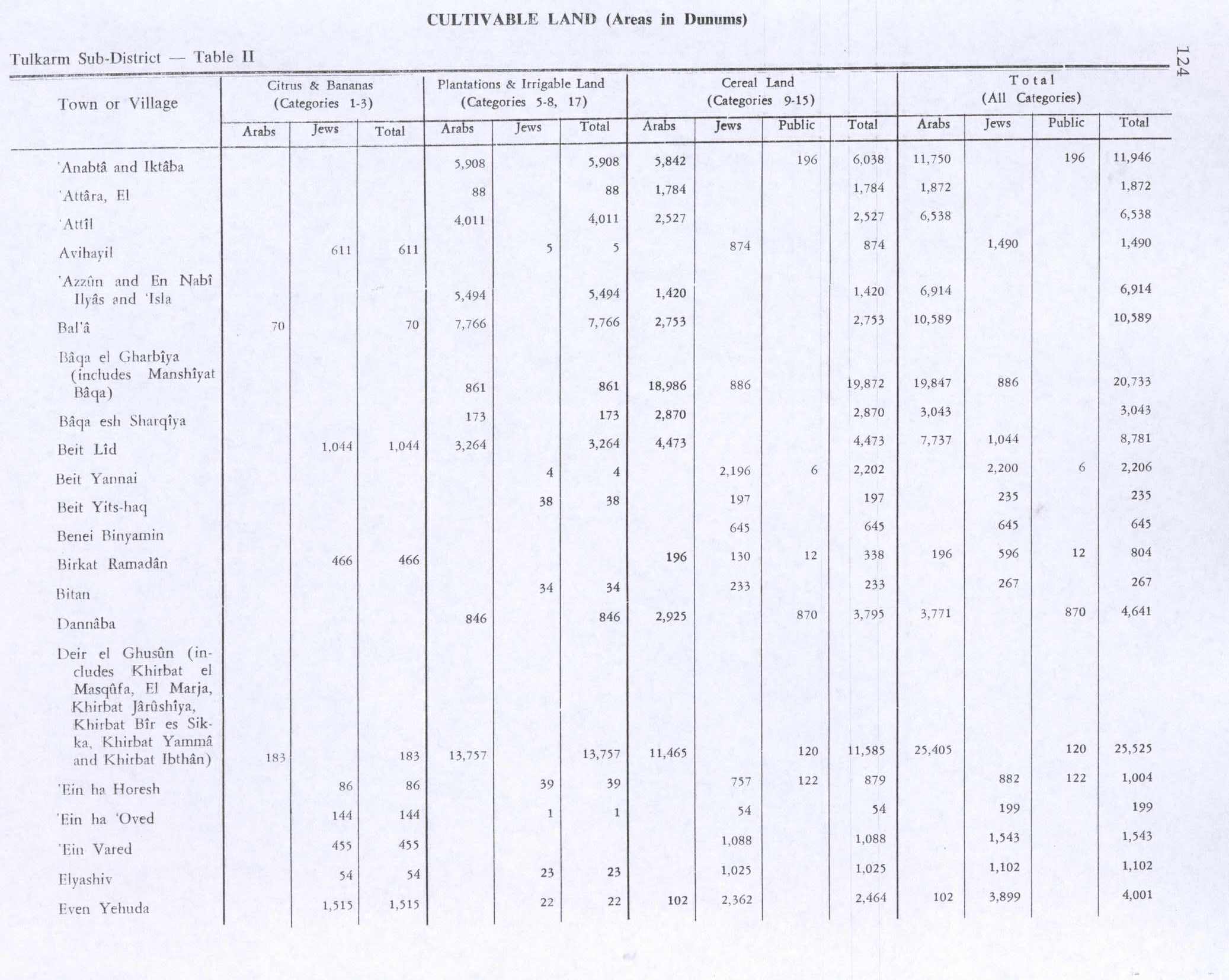
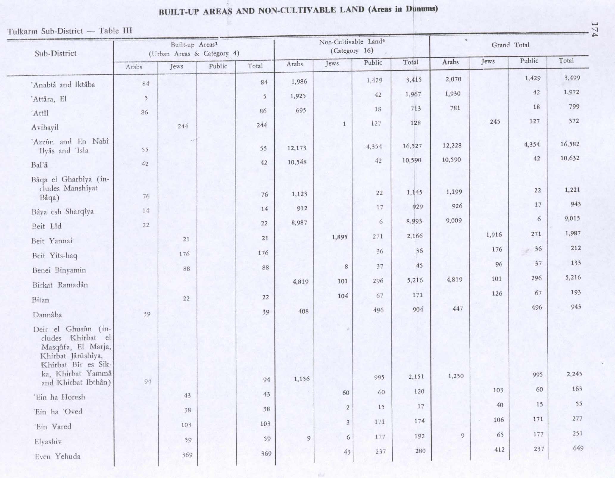
In 1945 the population of Baqa al-Gharbiyye (including Manshiyat Baqa) consisted of 2,240 Arabs with a total land area of 21,116 dunams, according to an official land and population survey.[11] Of this, 861 dunams were designated for plantations and irrigable land, 18,986 for cereals,[12] while 76 dunams were built-up areas.[13]
Israel


In the early years of Israeli independence, Baqa al-Gharbiyye was one of the headquarters of the Israeli military administration.[15] The land holdings of the town, which had been 21,116 dunams in 1945, were reduced to 8,228 dunams by 1962, mostly due to expropriation in 1953–1954.[15] In 1963, the Baka canning plant went into partnership with Priman, an Israeli company that relocated to Baqa al-Gharibiyye.[14]
In 1996, Baqa al-Gharbiyye was declared a city. In 2003 it was combined with the nearby town Jatt to become the city of Baqa-Jatt.[16]
Baqa al-Gharbiyye is separated from its West Bank sister city, Baqa ash-Sharqiyya (or Baqa East), by the Israeli West Bank barrier which in this section coincides with the Green Line.[17] As a result, a concrete wall topped with barbed wire runs through one neighbourhood.[18]
As the Israeli foreign minister in April and June 2008, Tzipi Livni raised the possibility of territorial exchange with Palestinian Authority President Mahmoud Abbas. She proposed transferring Israeli Arab communities, among them Baqa al-Garbiyeh, to the Palestinian side of the border. The Palestinians rejected the proposal.[19]
Demographics

In 2003, the official population was 24,000. Together with Jatt the estimated population is 32,500. The ethnic makeup of the city is entirely Muslim Arab, with no Jewish population and some European and foreign exceptions. The city is made up of 51% males and 49% females. Baqa has a population growth rate of 3.1%. The population of the city is spread out with 48.6% 19 years of age or younger, 18.4% between 20 and 29, 18.9% between 30 and 44, 9.5% from 45 to 59, 1.8% from 60 to 64, and 2.8% 65 years of age or older.
Education and culture

According to CBS, 47.8% of 12th grade students were entitled to a matriculation certificate in 2001. There are 6 elementary school, two junior-high schools and two high school, in addition to a private school. In addition to the official education institutions, Baqa has a wide range of private educational institutions which provide services to the city residents as well as people from the whole region. In addition, The Al-Rahma School (مدرسة الرحمة) in the city provides Special education for the city and the surrounding towns and villages.
The Al-Qasemi Academic College of Education, located in the city, as well-known students come to it for studying from all around the country, and has a combined Arab and Jewish faculty. The college is growing and expanding rapidly as a part of the Al-Qasemi group of projects for establishing high-standards private education in the city including the private school, a library and several centers for extra-education.[20]
Economy
Baqa al-Gharbiyye is considered a commercial and industrial center for nearby towns, villages and kibbutzim. There are over 400 workshops in Baqa. Industrial zones make up 8.5% of city's area.
Environmental issues
In 2007, the mayors of Baqa al-Gharbiyya and Baqa ash-Sharqiyya signed an agreement to clean up Wadi Abu Nar, a polluted stream that runs through both villages. The mayors also committed to protecting the mountain aquifer, the most important underground water source for Israelis and Palestinians, by establishing an authorized sewage grid-system. Baqa al-Gharbiyya agreed to connect the town's sewage treatment plant with a waste disposal network in Baqa al Sharkiya.[21]
Notable residents
References
- ↑ "List of localities, in Alphabetical order" (PDF). Israel Central Bureau of Statistics. Retrieved 16 October 2016.
- ↑ Palmer, 1881, p. 179
- ↑ Mahajna, 2007, Baqa al-Gharbiya (East)
- ↑ Dauphin, 1998, p. 755
- ↑ Sharvit, 2009, Baqa el-Gharbiya
- ↑ Hütteroth and Abdulfattah, 1977, p. 127
- ↑ Guérin, 1875, p. 345, partly translated in Conder and Kitchener, 1882, SWP II, p. 171
- ↑ Conder and Kitchener, 1882, SWP II, p. 152
- ↑ Barron, 1923, Table IX, Sub-district of Tulkarem, p. 27
- 1 2 Mills, 1932, p. 53
- ↑ Government of Palestine, Department of Statistics. Village Statistics, April, 1945. Quoted in Hadawi, 1970, p. 74
- ↑ Government of Palestine, Department of Statistics. Village Statistics, April, 1945. Quoted in Hadawi, 1970, p. 124
- ↑ Government of Palestine, Department of Statistics. Village Statistics, April, 1945. Quoted in Hadawi, 1970, p. 174
- 1 2 Arab-Jewish Economic Cooperation in Palestine
- 1 2 Sabri Jiryis (1976). The Arabs in Israel. New York and London: Monthly Review Press. pp. 24,292. ISBN 0-85345-377-2.
- ↑ Kobi Peled (2010). "The Well of Forgetfulness and Remembrance: milieu de mémoire and lieu de mémoire in a Palestinian Arab Town in Israel". British Journal of Middle Eastern Studies. 37 (2): 139–158. doi:10.1080/13530191003794715.
- ↑ Gidon Remba (2004-08-02). "Palestinians:Fenced into Limbo". MidEast Web. Retrieved 2007-11-05.
- ↑ Lucy Ash (2004-12-23). "Battling Against Israeli 'Apartheid'". BBC News. Retrieved 2007-11-05.
- ↑ 'Livni proposed moving several Israeli Arab towns to Palestinian side of border', Haaretz
- ↑ Al-Qasemi Academic College of Education
- ↑ Israeli and Palestinian Mayors Battle Pollution
Bibliography
| Wikimedia Commons has media related to Baqa al-Gharbiyye. |
- Barron, J. B., ed. (1923). Palestine: Report and General Abstracts of the Census of 1922. Government of Palestine.
- Conder, Claude Reignier; Kitchener, H. H. (1882). The Survey of Western Palestine: Memoirs of the Topography, Orography, Hydrography, and Archaeology. 2. London: Committee of the Palestine Exploration Fund.
- Dauphin, Claudine (1998). La Palestine byzantine, Peuplement et Populations. BAR International Series 726 (in French). III : Catalogue. Oxford: Archeopress.
- Guérin, Victor (1875). Description Géographique Historique et Archéologique de la Palestine (in French). 2: Samarie, pt. 2. Paris: L'Imprimerie Nationale.
- Hadawi, Sami (1970). Village Statistics of 1945: A Classification of Land and Area ownership in Palestine. Palestine Liberation Organization Research Center.
- Hütteroth, Wolf-Dieter; Abdulfattah, Kamal (1977). Historical Geography of Palestine, Transjordan and Southern Syria in the Late 16th Century. Erlanger Geographische Arbeiten, Sonderband 5. Erlangen, Germany: Vorstand der Fränkischen Geographischen Gesellschaft. ISBN 3-920405-41-2.
- Karmon, Y. (1960). "An Analysis of Jacotin's Map of Palestine" (PDF). Israel Exploration Journal. 10 (3,4): 155–173; 244–253. (Karmon, p. 169)
- Mahajna, Shireen (2007-10-16). "Baqa al-Gharbiya (East)" (119). Hadashot Arkheologiyot – Excavations and Surveys in Israel.
- Mills, E., ed. (1932). Census of Palestine 1931. Population of Villages, Towns and Administrative Areas. Jerusalem: Government of Palestine.
- Palmer, E. H. (1881). The Survey of Western Palestine: Arabic and English Name Lists Collected During the Survey by Lieutenants Conder and Kitchener, R. E. Transliterated and Explained by E.H. Palmer. Committee of the Palestine Exploration Fund.
- Sharvit, Jacob (2009-02-16). "Baqa al-Gharbiya" (121). Hadashot Arkheologiyot – Excavations and Surveys in Israel.
External links
- Welcome To Baqa al-Gharbiya
- Survey of Western Palestine, Map 11: IAA, Wikimedia commons
- אתר העירייה موقع بلدية باقة الغربية http://baqa.co.il/