Macarthur, Victoria
| Macarthur Victoria | |
|---|---|
 Mechanics' Institute Hall | |
 Macarthur | |
| Coordinates | 38°01′S 142°00′E / 38.017°S 142.000°ECoordinates: 38°01′S 142°00′E / 38.017°S 142.000°E |
| Population | 618 (2011 census)[1] |
| Postcode(s) | 3286 |
| LGA(s) | Shire of Moyne |
| State electorate(s) | Polwarth |
| Federal Division(s) | Wannon |
Macarthur /məˈkɑːθə/[2] is a town in the Western District of Victoria, Australia on the Hamilton-Port Fairy Road. It is in the Shire of Moyne local government area and the federal Division of Wannon. At the 2011 census, Macarthur and the surrounding area had a population of 618.[1]
History
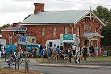
The Macarthur Court House building, now the Historical Society, during the 2009 Great Victorian Bike Ride
Macarthur Post Office opened 1 January 1862.[3]
Community
The town in conjunction with neighbouring township Hawkesdale has an Australian Rules football team competing in the Mininera & District Football League.
Golfers play at the course of the Macarthur Golf Club on Hamilton Road.[4]
Macarthur is also the site of the large Macarthur Wind Farm, completed in 2013.
References
- 1 2 Australian Bureau of Statistics (31 October 2012). "Macarthur (State Suburb)". 2011 Census QuickStats. Retrieved 2014-11-04.
- ↑ Butler, S., ed. (2009). "Macarthur". Macquarie Dictionary (5th ed.). Sydney: Macquarie Dictionary Publishers Pty Ltd. 1952 pages. ISBN 978-1-876429-66-9.
- ↑ Premier Postal History, Post Office List, retrieved 2008-04-11
- ↑ Golf Select, Macarthur, retrieved 2009-05-11
External links
| Wikimedia Commons has media related to Macarthur, Victoria. |
This article is issued from Wikipedia - version of the 10/3/2016. The text is available under the Creative Commons Attribution/Share Alike but additional terms may apply for the media files.