Lupi, Camarines Sur
| Lupi | ||
|---|---|---|
| Municipality | ||
| ||
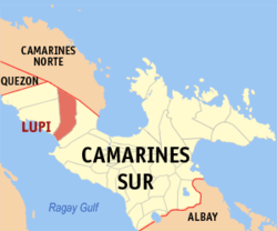 Map of Camarines Sur showing the location of Lupi | ||
.svg.png) Lupi Location within the Philippines | ||
| Coordinates: 13°49′N 122°54′E / 13.82°N 122.9°ECoordinates: 13°49′N 122°54′E / 13.82°N 122.9°E | ||
| Country | Philippines | |
| Region | Bicol (Region V) | |
| Province | Camarines Sur | |
| District | 1st district | |
| Founded | 1726 (as a distinct municipality) | |
| Barangays | 38 | |
| Government[1] | ||
| • Mayor | Bobby Matamorosa | |
| Area[2] | ||
| • Total | 199.12 km2 (76.88 sq mi) | |
| Population (2015 census)[3] | ||
| • Total | 32,167 | |
| • Density | 160/km2 (420/sq mi) | |
| Time zone | PST (UTC+8) | |
| ZIP code | 4409 | |
| IDD : area code | +63 (0)54 | |
| Income class | 3rd class | |

Lupi is a third class municipality in the province of Camarines Sur, Philippines. According to the 2015 census, it has a population of 32,167 people.[3]
History
Lupi, in the first district of the province, was branded as a "travelling poblacion" as it had been transferred several times when it was a small settlement during Spanish rule. On 17 October 1726, however, the Spanish government under the administration of Governor General Marquéz de Torrecampo who was also the titular head of the Diocese of Caceres, issued a decree making Lupi a separate town.
Barangays
Lupi is politically subdivided into 38 barangays.[2]
- Alleomar
- Bagangan Sr.
- Bagong Sikat
- Bel-Cruz
- Bangon
- Barrera Jr.
- Barrera Sr.
- Belwang
- Buenasuerte
- Bulawan Jr.
- Bulawan Sr.
- Cabutagan
- Casay
- Colacling (Del Rosario)
- Cristo Rey
- Del Carmen
- Haguimit
- Halubán (Pigbasagan)
- Kaibigan
- La Purísima
- Lourdes
- Mangcawayan
- Napolidan
- Población
- Polantuna
- Sagrada
- Salvación
- San Isidro
- San José
- San Pedro
- San Rafael Norte
- San Rafael Sur
- San Ramon
- San Vicente
- Sooc
- Tanawán
- Tible
- Tapi (Lupi Nuevo)
Demographics
| Population census of Lupi | ||
|---|---|---|
| Year | Pop. | ±% p.a. |
| 1990 | 24,809 | — |
| 1995 | 25,390 | +0.43% |
| 2000 | 26,148 | +0.63% |
| 2007 | 27,630 | +0.76% |
| 2010 | 30,118 | +3.19% |
| 2015 | 32,167 | +1.26% |
| Source: Philippine Statistics Authority[3][4][5] | ||
In the 2015 census, the population of Lupi, Camarines Sur, was 32,167 people,[3] with a density of 160 inhabitants per square kilometre or 410 inhabitants per square mile.
References
- ↑ "Municipalities". Quezon City, Philippines: Department of the Interior and Local Government. Retrieved 2 January 2013.
- 1 2 "Province: CAMARINES SUR". PSGC Interactive. Makati City, Philippines: National Statistical Coordination Board. Retrieved 2 January 2013.
- 1 2 3 4 "Region V (BICOL REGION)". Census of Population (2015): Total Population by Province, City, Municipality and Barangay (Report). PSA. Retrieved 20 June 2016.
- ↑ "Region V (BICOL REGION)". Census of Population and Housing (2010): Total Population by Province, City, Municipality and Barangay (Report). NSO. Retrieved 29 June 2016.
- ↑ "Province of Camarines Sur". Municipality Population Data. LWUA Research Division. Retrieved 24 July 2013.
External links
- Philippine Standard Geographic Code
- Official Site of the Province of Camarines Sur
- Philippine Census Information
 |
Del Gallego | San Lorenzo Ruiz, Camarines Norte | Basud, Camarines Norte | |
| Ragay | |
Sipocot | ||
| ||||
| | ||||
| Ragay Gulf | Sipocot |
Pili (capital) | |
| Municipalities | |
| Component city | |
| Independent component city |
|