Malilipot, Albay
| Malilipot | |
|---|---|
| Municipality | |
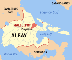 Location within Albay province | |
.svg.png) Malilipot Location within the Philippines | |
| Coordinates: 13°19′N 123°44′E / 13.32°N 123.73°ECoordinates: 13°19′N 123°44′E / 13.32°N 123.73°E | |
| Country | Philippines |
| Region | Bicol Region (Region V) |
| Province | Albay |
| District | 1st district |
| Barangays | 18 (see Barangays) |
| Government [1] | |
| • Type | Sangguniang Bayan |
| • Mayor | Cenon B. Volante |
| Area[2] | |
| • Total | 44.13 km2 (17.04 sq mi) |
| Population (2015 census)[3] | |
| • Total | 37,785 |
| • Density | 860/km2 (2,200/sq mi) |
| • Voter (2016)[4] | 24,750 |
| Time zone | PST (UTC+8) |
| ZIP code | 4510 |
| IDD : area code | +63 (0)52 |
| Income class | 4th class |
| PSGC | 050509000 |
Malilipot, officially the Municipality of Malilipot (Filipino: Bayan ng Malilipot), is a municipality in the province of Albay in the Bicol Region (Region V) of the Philippines. The population was 37,785 at the 2015 census.[3] In the 2016 election, it had 24,750 registered voters.[4]
History
Malilipot traces its history to the expedition of Juan de Salcedo in 1573 and the colonization of Albay Bay, now called Albay, with 120 soldiers and guides. During these period, towns were established. Libon was founded in 1573, Polangui in 1589, Oas in 1587, and Malinao in 1600. Other municipalities were established in succession. A story alleged that the Spanish colonizers reached this new settlement in the month of December. The weather was so cold that the Spaniards exclaimed "muy frio" which the natives interpreted as "Malilipot" meaning "very cold".
Another story alleged that when a Spanish ship disembarked on the bay of Malilipot, Spaniards asked a native fishermen for the name of the place. Due to language barrier, the natives thought he was asked what are their conditions, to which they replied "nalilipot kami". The Spaniards then conclude that the place was "Malilipot".
Another legendary name given to the town was "Manlipod" meaning "Protector" attributed to the mountain ranges which had protected the town from the early destructive eruptions of Mayon Volcano. It was said that, had it not been for these mountain ranges, the poblacion would have been buried under the molten lava and ashes emitted by Mount Mayon. These protective mountains are Toktokan and Bulawan (meaning "gold") situated on the southern part and extends to the western side of the town, and screens it from the ravages of Mayon Volcano. The town is popularly known as Malilipot. Now, the official name of the town is Malilipot (Ma-li-li-pot), accented on the third syllable.
Geography
Malilipot is located at 13°19′N 123°44′E / 13.32°N 123.73°E.
According to the Philippine Statistics Authority, the municipality has a land area of 44.13 square kilometres (17.04 sq mi)[2] constituting 1.71% of the 2,575.77-square-kilometre- (994.51 sq mi) total area of Albay.
Barangays
Malilipot is politically subdivided into 18 barangays.[5]
The sitios of Calbayog and Canaway were converted into a barrios in 1959 and 1957, respectively.[6][7]
| PSGC | Barangay | Population | ±% p.a. | ||
|---|---|---|---|---|---|
| 2015[3] | 2010[8] | ||||
| 050509004 | Barangay I (Poblacion) | 5.7% | 2,152 | 2,075 | +0.70% |
| 050509005 | Barangay II (Poblacion) | 1.6% | 597 | 540 | +1.93% |
| 050509006 | Barangay III (Poblacion) | 3.4% | 1,295 | 1,164 | +2.05% |
| 050509007 | Barangay IV (Poblacion) | 4.3% | 1,614 | 1,524 | +1.10% |
| 050509008 | Barangay V (Poblacion) | 3.3% | 1,264 | 1,122 | +2.29% |
| 050509001 | Binitayan | 4.9% | 1,834 | 1,654 | +1.99% |
| 050509002 | Calbayog | 5.5% | 2,094 | 2,029 | +0.60% |
| 050509003 | Canaway | 6.9% | 2,599 | 2,425 | +1.33% |
| 050509009 | Salvacion | 3.1% | 1,176 | 1,220 | −0.70% |
| 050509010 | San Antonio Santicon (Poblacion) | 2.1% | 791 | 762 | +0.71% |
| 050509011 | San Antonio Sulong | 2.1% | 794 | 792 | +0.05% |
| 050509012 | San Francisco | 4.1% | 1,565 | 1,476 | +1.12% |
| 050509013 | San Isidro Ilawod | 9.8% | 3,705 | 3,528 | +0.94% |
| 050509014 | San Isidro Iraya | 12.4% | 4,686 | 4,330 | +1.52% |
| 050509015 | San Jose | 13.5% | 5,110 | 4,715 | +1.54% |
| 050509016 | San Roque | 6.0% | 2,277 | 2,047 | +2.05% |
| 050509017 | Santa Cruz | 4.4% | 1,659 | 1,599 | +0.70% |
| 050509018 | Santa Teresa | 6.8% | 2,573 | 2,565 | +0.06% |
| Total | 37,785 | 35,567 | +1.16% | ||
Demographics
| Population census of Malilipot | |||||||||||||||||||||||||
|---|---|---|---|---|---|---|---|---|---|---|---|---|---|---|---|---|---|---|---|---|---|---|---|---|---|
|
| ||||||||||||||||||||||||
| Source: PSA[3][8][9] | |||||||||||||||||||||||||
In the 2015 census, Malilipot had a population of 37,785.[3] The population density was 860 inhabitants per square kilometre (2,200/sq mi).
In the 2016 election, it had 24,750 registered voters.[4]
Attractions
"For lovers of waterfalls in more or less unspoiled nature a day trip from Legaspi to Malilipot can be warmly recommended. From here, on the north-east foothills of Mayon, there is a path leading in the direction of the volcano to the Busay Falls. These falls descend in stages from a height of 250 meters, flowing into seven pools on the way that tempt you to swim in them. If you don't want to jump straight into the first pool, then turn off onto the path on the right just before it. After about a 15-minute this will take you to the second pool."[10]
References
- ↑ "Municipality". Quezon City, Philippines: Department of the Interior and Local Government. Retrieved 31 May 2013.
- 1 2 "Province: Albay". PSGC Interactive. Makati City, Philippines: Philippine Statistics Authority. Retrieved 28 October 2016.
- 1 2 3 4 5 "Region V (BICOL REGION)". Census of Population (2015): Total Population by Province, City, Municipality and Barangay (Report). PSA. Retrieved 20 June 2016.
- 1 2 3 "2016 National and Local Elections Statistics". Commission on Elections. 2016.
- ↑ "Municipal: Malilipot, Albay". PSGC Interactive. Quezon City, Philippines: Philippine Statistics Authority. Retrieved 8 January 2016.
- ↑ "Republic Act No. 2524; An Act Converting the Sitio of Calbayog, Municipality of Malilipot, Province of Albay, into a Barrio of Said Municipality". The Corpus Juris. 21 June 1959. Archived from the original on 24 October 2016. Retrieved 24 October 2016.
- ↑ "Republic Act No. 1640; An Act to Convert the Sitio of Canaway in the Municipality of Malilipot, Province of Albay, into a Barrio". The Corpus Juris. 20 June 1957. Archived from the original on 9 December 2016. Retrieved 24 October 2016.
- 1 2 "Region V (BICOL REGION)". Census of Population and Housing (2010): Total Population by Province, City, Municipality and Barangay (Report). NSO. Retrieved 29 June 2016.
- ↑ "Region V (BICOL REGION)". Census of Population (1995, 2000 and 2007): Total Population by Province, City and Municipality (Report). NSO. Archived from the original on 24 June 2011.
- ↑ Peters, Jens. Philippines a travel survival kit. Australia: Lonely Planet, 1996
 |
Tabaco | Lagonoy Gulf | | |
| Tabaco | |
Bacacay | ||
| ||||
| | ||||
| Mayon Volcano | Santo Domingo |
Legazpi (capital) | |
| Municipalities | |
| Component cities | |