Uson, Masbate
| Uson | |
|---|---|
| Municipality | |
|
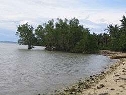
Beach and Mangroves | |
 Map of Masbate with Uson highlighted | |
.svg.png) Uson Location within the Philippines | |
| Coordinates: 12°13′N 123°47′E / 12.217°N 123.783°ECoordinates: 12°13′N 123°47′E / 12.217°N 123.783°E | |
| Country | Philippines |
| Region | Bicol (Region V) |
| Province | Masbate |
| District | 3rd district |
| Barangays | 35 |
| Government[1] | |
| • Mayor | Salvadora O. Sanchez |
| Area[2] | |
| • Total | 163.20 km2 (63.01 sq mi) |
| Population (2010)[3] | |
| • Total | 53,602 |
| • Density | 330/km2 (850/sq mi) |
| Time zone | PST (UTC+8) |
| Zip Code | 5402 |
| Dialing code | 56 |
Uson is a third class municipality in the province of Masbate, Philippines. It is about 42 kilometres (26 mi) southeast of Masbate City, connected by a paved coastal road, and located on Uson Bay which has an approximate area of 15 square kilometres (5.8 sq mi). According to the 2010 census, it has a population of 53,602 people.[3]
Geography
The municipality is bounded by the municipality of Mobo on the north with the Balatucan river; on the east Uson is bounded by the Barangay Balocawe of the municipality of Dimasalang; on the south it is bounded by the Baldosa river and Palo Bandera of Cawayan; on the west the municipality is bounded by Milagros.
With and elevation of 604 metres (1,982 ft) above sea level, Mount Uac is the highest point of the municipality. The mountain borders the three municipalities of Uson, Mobo and Milagros.
Uson has several rivers, including Balucaw River, Buenavista River, Buracan River, Calpi River, Dap-dap River, Mongahay River, Pinangapugan (Quezon) River, and the Sawang River which all flow into Uson Bay. East of the poblacion a lake can be found, Lake Calero.
Seismic activity
The Philippine Fault System from which almost all of the recorded strong earthquakes in the Philippines emanated, traverses eastern Uson. As a result, strong seismic activity in the form of frequent earthquakes can be experienced. Link to PHIVOLCS website
Barangays
Uson is politically subdivided into 35 barangays.[2]
- Arado
- Armenia
- Aurora
- Badling
- Bonifacio
- Buenasuerte
- Buenavista
- Campana
- Candelaria
- Centro
- Crossing
- Dapdap
- Del Carmen
- Del Rosario
- Libertad
- Madao
- Mabini
- Magsaysay
- Marcella
- Miaga
- Mongahay
- Morocborocan
- Mabuhay
- Paguihaman
- Panicijan
- Poblacion
- Quezon
- San Isidro
- San Jose
- San Mateo
- San Ramon
- San Vicente
- Santo Cristo
- Sawang
- Simawa
Demographics
| Population census of Uson | ||
|---|---|---|
| Year | Pop. | ±% p.a. |
| 1990 | 37,265 | — |
| 1995 | 39,251 | +0.98% |
| 2000 | 43,825 | +2.39% |
| 2007 | 50,404 | +1.95% |
| 2010 | 53,602 | +2.26% |
| Source: National Statistics Office[3][4] | ||
References
- ↑ "Municipalities". Quezon City, Philippines: Department of the Interior and Local Government. Retrieved 24 January 2013.
- 1 2 "Province: Masbate". PSGC Interactive. Makati City, Philippines: National Statistical Coordination Board. Retrieved 24 January 2013.
- 1 2 3 "Total Population by Province, City, Municipality and Barangay: as of May 1, 2010" (PDF). 2010 Census of Population and Housing. National Statistics Office. Retrieved 20 January 2013.
- ↑ "Province of Masbate". Municipality Population Data. LWUA Research Division. Retrieved 23 July 2013.
External links
| Wikimedia Commons has media related to Uson, Masbate. |
- Philippine Standard Geographic Code
- Philippine Census Information
- Local Governance Performance Management System
 |
Mobo | Batuan Masbate Pass |
Samar Sea | |
| Milagros | |
Dimasalang | ||
| ||||
| | ||||
| Cawayan |
Masbate City (capital) | |
| Municipalities | |
| Component city | |