Manito, Albay
| Manito | ||
|---|---|---|
| Municipality | ||
| ||
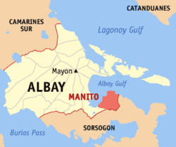 Location within of Albay province | ||
.svg.png) Manito Location within the Philippines | ||
| Coordinates: 13°07′N 123°52′E / 13.12°N 123.87°ECoordinates: 13°07′N 123°52′E / 13.12°N 123.87°E | ||
| Country | Philippines | |
| Region | Bicol Region (Region V) | |
| Province | Albay | |
| District | 2nd district | |
| Incorporated | 1840 | |
| Named for | Nito vines that proliferate in the area | |
| Barangays | 15 (see Barangays) | |
| Government [1] | ||
| • Type | Sangguniang Bayan | |
| • Mayor | Cesar S. Daep | |
| Area[2] | ||
| • Total | 107.4 km2 (41.5 sq mi) | |
| Area rank | 14th out of the 18 cities/municipalities | |
| Highest elevation[3] | 760 m (2,490 ft) | |
| Lowest elevation | 0 m (0 ft) | |
| Population (2015 census)[4] | ||
| • Total | 24,707 | |
| • Rank | 17th out of the 18th cities/municipalities | |
| • Density | 230/km2 (600/sq mi) | |
| • Voter (2016)[5] | 13,905 | |
| Time zone | PST (UTC+8) | |
| ZIP code | 4514 | |
| IDD : area code | +63 (0)52 | |
| Income class | 4th class | |
| PSGC | 050511000 | |

Manito, officially the Municipality of Manito (Filipino: Bayan ng Manito), is a municipality in the province of Albay in the Bicol Region (Region V) of the Philippines. The population was 24,707 at the 2015 census.[4] In the 2016 election, it had 13,905 registered voters.[5]
History
The first settlers in the area came from Bacon, Cagraray Island or Casiguran which are geographically situated near Manito. In prehistoric time, the Bicolanos from the above-mentioned places had shown evidence of civilization. Recently artifacts unearthed from this place both by Filipino and foreign anthropologist show that Bicol is indeed inhabited first by Bicolanos, not traders from foreign lands.
In 1840, a few settlers the Visayas came and settled in the place near the coast of Manito, because of fear from Moro invaders. They officially established the place and named it Manito, because it was abounding in clinging vine called nito, which belongs to the rattan family and is used as raw material for making baskets. When nito vines are artistically made into baskets, the finished products are natural dark brown in color similar to the color of coffee. The prefix "Ma" means "plenty", then Manito means "plenty of nito".
Later, natives from the neighboring towns of Albay, Bacon, and Rapu-rapu who fled from the Moro raiders found a safer place near the seashore and near the thick west Of Manito. In the past this town was surrounded by thick forest that gave natural fiction — a haven of safety and comfort — to the Visayan settlers. Although they were brave and courageous, they lacked arms and ammunitions to fight the Moros.
In the early years of settlement, the center of this place that soon became the Poblacion had only a few scattered houses.As forests were cut, the cleared areas were planted with abaca and other crops. Due to the abundance of food and money which the people earned through the sale of their forest and agricultural products, Manito became a progressive settlement. But today it is left behind by neighboring towns. Forests are mostly denuded due to cutting in the 1980s, while replanting of trees has been neglected.
Geography
Manito is located at 13°07′N 123°52′E / 13.12°N 123.87°E.
According to the Philippine Statistics Authority, the municipality has a land area of 107.4 square kilometres (41.5 sq mi)[2] constituting 4.17% of the 2,575.77-square-kilometre- (994.51 sq mi) total area of Albay.
Manito is located on the south-eastern tip of Albay, adjoining the south-eastern limit of Legazpi City. The west and NW coast of Manito lies along Poliqui Bay opposite the city of Legazpi. To the north and north-east coast of the municipality lies Albay Gulf. To the east and south of Manito is the province of Sorsogon separated by the Pocdol Mountains, which is also called as the Bacon-Manito Volcanic Complex. Because of topography, the two provinces are not connected along the coast. A mountain pass from barangay Nagotgot connects Manito to Sorsogon City in Sorsogon province.
Southwest of the poblacion is barangay Buyo separated by the Buyo River. The two rivers serve as irrigation for small rice fields and water sources for the residents.
Geography
Barangays
Manito is politically subdivided into 15 barangays.[6] 14 are classified as rural areas and only the poblacion (town center, also known as Brgy. It-ba), is classified as an urban area.[7] The poblacion is situated on the north-western seashore of the town, south of the mouth of the Camanitohan River. Northwest of the town center is barangay Cawit, separated by the Caminatohan.
| PSGC | Barangay | Population | ±% p.a. | ||
|---|---|---|---|---|---|
| 2015[4] | 2010[8] | ||||
| 050511001 | Balabagon | 2.1% | 507 | 561 | −1.91% |
| 050511002 | Balasbas | 6.4% | 1,581 | 1,399 | +2.36% |
| 050511003 | Bamban | 4.1% | 1,010 | 967 | +0.83% |
| 050511004 | Buyo | 16.3% | 4,038 | 3,575 | +2.35% |
| 050511005 | Cabacongan | 3.8% | 945 | 946 | −0.02% |
| 050511006 | Cabit | 4.4% | 1,093 | 1,072 | +0.37% |
| 050511007 | Cawayan | 7.3% | 1,805 | 1,665 | +1.55% |
| 050511008 | Cawit | 4.1% | 1,013 | 1,011 | +0.04% |
| 050511009 | Holugan | 4.9% | 1,199 | 1,165 | +0.55% |
| 050511010 | It-Ba (Poblacion) | 14.5% | 3,588 | 3,192 | +2.25% |
| 050511011 | Malobago | 3.9% | 958 | 945 | +0.26% |
| 050511012 | Manumbalay | 4.0% | 998 | 812 | +4.01% |
| 050511013 | Nagotgot | 10.2% | 2,510 | 2,366 | +1.13% |
| 050511015 | Pawa | 9.3% | 2,297 | 2,114 | +1.59% |
| 050511018 | Tinapian | 4.7% | 1,165 | 1,029 | +2.39% |
| Total | 24,707 | 22,819 | +1.53% | ||
Demographics
| Population census of Manito | |||||||||||||||||||||||||
|---|---|---|---|---|---|---|---|---|---|---|---|---|---|---|---|---|---|---|---|---|---|---|---|---|---|
|
| ||||||||||||||||||||||||
| Source: PSA[4][8][9] | |||||||||||||||||||||||||
In the 2015 census, Manito had a population of 24,707.[4] The population density was 230 inhabitants per square kilometre (600/sq mi).
In the 2016 election, it had 13,905 registered voters.[5]
Economy
The municipality is a supplier of lasa grass and its final product - soft broom. A significant number of households are engaged in soft broom making as a source of livelihood. Many households are still engaged in cottage industries like basket making in spite of the dwindling supply of nito vines.
In 1982, the municipality of Manito emerged in the limelight by virtue of PD k.20364 establishing Manito as reservation area for Geothermal Exploration and development. On June 1994, the Bacman Geothermal Production Field has started its full operation and on October 1998, President Joseph Estrada inaugurated the additional 1.5 megawatt power/multi-crop drying plant located at Pawa, Manito in support of his food security program.
Town fiesta
Saint Raphael the Archangel is the patron saint of Manito where the town fiesta is celebrated every October 24 in his honor.
References
- ↑ "Municipality". Quezon City, Philippines: Department of the Interior and Local Government. Retrieved 31 May 2013.
- 1 2 "Province: Albay". PSGC Interactive. Makati City, Philippines: Philippine Statistics Authority. Retrieved 28 October 2016.
- ↑ "Manito, Albay, Philippines - Terrain map". Google Maps. Retrieved on 2012-05-20.
- 1 2 3 4 5 "Region V (BICOL REGION)". Census of Population (2015): Total Population by Province, City, Municipality and Barangay (Report). PSA. Retrieved 20 June 2016.
- 1 2 3 "2016 National and Local Elections Statistics". Commission on Elections. 2016.
- ↑ "Municipal: Manito, Albay". PSGC Interactive. Quezon City, Philippines: Philippine Statistics Authority. Retrieved 8 January 2016.
- ↑ (2007-08-01). "Municipality//City: Manito". Philippines Standard Geographic Code Interactive. Retrieved on 2012-05-20.
- 1 2 "Region V (BICOL REGION)". Census of Population and Housing (2010): Total Population by Province, City, Municipality and Barangay (Report). NSO. Retrieved 29 June 2016.
- ↑ "Region V (BICOL REGION)". Census of Population (1995, 2000 and 2007): Total Population by Province, City and Municipality (Report). NSO. Archived from the original on 24 June 2011.
External links
 |
Santo Domingo Albay Gulf |
Bacacay Albay Gulf |
Rapu-Rapu Albay Gulf |
|
| Legazpi | |
Sorsogon City | ||
| ||||
| | ||||
| Castilla, Sorsogon |
Legazpi (capital) | |
| Municipalities | |
| Component cities | |