Capalonga, Camarines Norte
| Capalonga | |
|---|---|
| Municipality | |
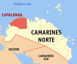 Map of Camarines Norte showing the location of Capalonga | |
.svg.png) Capalonga Location within the Philippines | |
| Coordinates: 14°20′N 122°30′E / 14.33°N 122.5°ECoordinates: 14°20′N 122°30′E / 14.33°N 122.5°E | |
| Country |
|
| Region | Bicol (Region V) |
| Province | Camarines Norte |
| District | 1st district |
| Barangays | 22 |
| Government[1] | |
| • Mayor | Senandro M. Jalgalado |
| Area[2] | |
| • Total | 290 km2 (110 sq mi) |
| Population (2015 census)[3] | |
| • Total | 32,215 |
| • Density | 110/km2 (290/sq mi) |
| Time zone | PST (UTC+8) |
| ZIP code | 4607 |
| IDD : area code | +63 (0)54 |
| Income class | 3rd class |
Capalonga is a third class municipality in the province of Camarines Norte, Philippines. According to the 2015 census, it has a population of 32,215 people.[3]
Barangays
Capalonga is politically subdivided into 22 barangays. In 1955, the sitio of Ilayang Basiad was converted into the barrio of San Pedro.[4]
- Alayao
- Binawangan
- Calabaca
- Camagsaan
- Catabaguangan
- Catioan
- Del Pilar
- Itok
- Lucbanan
- Mabini
- Mactang
- Mataque
- Old Camp
- Poblacion
- Magsaysay
- San Antonio
- San Isidro
- San Roque
- Tanauan
- Ubang
- Villa Aurora
- Villa Belen
History
Agtas and Dumagats, are believed to be the first inhabitants of village used to be called "Apalong". This name was derived from a wild plant called "Palong Manok", which looks like a rooster's comb. It is said that whenever the settlers of Apalong went to other places and asked where they came from, the usual reply is "We came from Kapalungan". Historians may comment that the natives were either referring to their place which has many "Palong" (roster's comb) or maybe they wanted identification for their settlement. Whatever it was, no record will show and no one at that time is still living, what is clearly known to Capalongueños is that this place was and still is an environment of flowers called Palong Manok. In 1572, the Spanish Conquistador Capt Juan de Salcedo and his men reached pacific shores and landed on Kapalongan settlement. Instead of finding gold, they found abundant wild beautiful red flowers that looked like roster's comb. The Spaniards built a church, formed a government, and the village was made a town and officially named Capalonga. The Spaniards for some years persisted on mining for gold at Sitio Maglagonlong, and the Spanish control was described to be brutal, harsh and full of harassment until they went away leaving behind imprints on the community's cultural heritage.
It is also believed that the first migrants of Capalonga came from the neighbouring province of Quezon, formerly Tayabas. This is the reason that out of the twelve (12) municipalities of Camarines Norte, Capalonga has the highest rating and accent in speaking the Tagalog language. However, with the continuous migration process, mixed dialects has been produced. Today, like other places in the country, the dialects of the residents were enriched by various local medium of expression, thereby making no difference from the trend of other political units.
Without roads and being isolated from other towns by mountains, forest, rivers and sea, Capalonga remained relatively undeveloped by commerce and industry as late as the 1950s. In 1956, the road to Capalonga was opened. Still, growth had been slow until Martial law changed the pace. It was in the years 1987 to 1992 that all wooden and temporary bridges have been replaced by concrete bridges. Likewise, in the late part of 2003 up to the present, the paving of the Bagong Silang - Capalonga Road has started and existence of the air-conditioned van transport is now available as a result.
Demographics
| Population census of Capalonga | ||
|---|---|---|
| Year | Pop. | ±% p.a. |
| 1990 | 23,557 | — |
| 1995 | 25,336 | +1.37% |
| 2000 | 26,577 | +1.03% |
| 2007 | 29,683 | +1.54% |
| 2010 | 31,299 | +1.95% |
| 2015 | 32,215 | +0.55% |
| Source: Philippine Statistics Authority[3][5][6] | ||
In the 2015 census, the population of Capalonga was 32,215 people,[3] with a density of 110 inhabitants per square kilometre or 280 inhabitants per square mile.
Tourism
- Nature
- Itok Falls - Located 4 km. west of the town with fresh and lush foliage and vegetation.
- Bangka-bangka Falls-Located at Barangay Catabaguangan.It is being called as Bangka-bangka(Boat),because of its boat-like shape.
- Albino Beach-Located at sitio Talagpucao Barangay Catioan with relaxing smooth waves and fine sand.
- Mount Samat-Located at Barangay Alayao. This mountain is covered by the undiscovered species of ferns, orchids, etc. There are also falls with fresh cold clear water.
- Festivals and Cultural Entertainments
- Feast of the Black Nazarene (May 13) - The town Fiesta in honor of the Black Nazarene draws devotees from all over the country. The image is said to be miraculous and its feast is particularly celebrated by Chinese businessmen, who pay annual homage and ask for long life and good fortune.
- Palong Festival (May 10–13) - Highlighted by colorful streetdancing and agro-industrial fair which expresses the local folks’ gratitude for their town’s name’s etymology, and signifies the abundant presence of "Palong Manok" (rooster's comb plant) available in the locality. Held also in celebration of the Black Nazarene’s Feast Day on May 13 at the town of Capalonga.
References
- ↑ "Municipalities". Quezon City, Philippines: Department of the Interior and Local Government. Archived from the original on 25 January 2013. Retrieved 28 December 2012.
- ↑ "Province: CAMARINES NORTE". PSGC Interactive. Makati City, Philippines: National Statistical Coordination Board. Retrieved 28 December 2012.
- 1 2 3 4 "Region V (BICOL REGION)". Census of Population (2015): Total Population by Province, City, Municipality and Barangay (Report). PSA. Retrieved 20 June 2016.
- ↑ "An Act Converting the Sitio of Ilayang Basiad in the Municipality of Capalonga, Province of Camarines Norte, into Barrio San Pedro of Said Municipality". LawPH.com. Retrieved 2011-04-12.
- ↑ "Region V (BICOL REGION)". Census of Population and Housing (2010): Total Population by Province, City, Municipality and Barangay (Report). NSO. Retrieved 29 June 2016.
- ↑ "Province of Camarines Norte". Municipality Population Data. LWUA Research Division. Retrieved 23 July 2013.
- Municipal Planning and Development Office LGU, Capalonga, Camarines Norte
External links
 |
Jomalig, Quezon Philippine Sea |
| ||
| Lamon Bay | |
Jose Panganiban | ||
| ||||
| | ||||
| Santa Elena | Labo |
Daet (capital) | |
| Municipalities | |