Kinderhook (village), New York
| Kinderhook, New York | |
|---|---|
| Village | |
 Location of Kinderhook, New York | |
| Coordinates: 42°23′37″N 73°42′18″W / 42.39361°N 73.70500°WCoordinates: 42°23′37″N 73°42′18″W / 42.39361°N 73.70500°W | |
| Country | United States |
| State | New York |
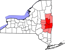
| County | Columbia |
| Town | Kinderhook |
| Area | |
| • Total | 2.1 sq mi (5.4 km2) |
| • Land | 2.1 sq mi (5.4 km2) |
| • Water | 0.0 sq mi (0.0 km2) |
| Elevation | 253 ft (77 m) |
| Population (2010) | |
| • Total | 1,211 |
| • Density | 575/sq mi (222.2/km2) |
| Time zone | Eastern (EST) (UTC-5) |
| • Summer (DST) | EDT (UTC-4) |
| ZIP code | 12106 |
| Area code(s) | 518 |
| FIPS code | 36-39562 |
| GNIS feature ID | 0954619 |
| Website |
villageofkinderhook |
Kinderhook (Kinderhoek in Dutch) is a village located in the town of Kinderhook in Columbia County, New York, United States. The village population was 1,211 at the 2010 census.[1]
The village of Kinderhook is located in the south-central part of the town on US 9.
History
The area was named by Henry Hudson in 1609 as Kinderhoek (Dutch for "children's corner") because he had seen Native American children frequently playing there. First settled by the Dutch around 1640, the area was surrendered to the English in 1664.
In 1686 the area was granted the Great Kinderhook Patent and organized into one township.
Much of the area's growth did not occur until the 19th century - in 1813 the village had only twenty dwellings. By 1843, the number had grown to 86, and just seven years later there were about 200 buildings and 1,400 inhabitants. The size of the village has remained steady since then, and the Kinderhook Village District has been listed on the National Register of Historic Places since 1974. In 1838, Kinderhook was chartered as a village.
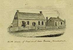
United States President Martin Van Buren was born in Kinderhook village, and was known as "Old Kinderhook", which was sometimes abbreviated as "O.K." Thus some sources attribute the use of the phrase "OK" to Van Buren and his supporters. The home where he was born, his father's tavern, no longer exists, but a historical marker is located on the site. The Martin Van Buren National Historic Site, Van Buren's retirement home, is located 1 mile (1.6 km) south of the village and is open to the public.
Geography
Kinderhook is located at 42°23′37″N 73°42′18″W / 42.39361°N 73.70500°W (42.393707, -73.705094).[2]
According to the United States Census Bureau, the village has a total area of 2.1 square miles (5.4 km2). None of the area is covered with water. Kinderhook Creek, a tributary of the Hudson River, forms the southeast boundary of the village.
Demographics
| Historical population | |||
|---|---|---|---|
| Census | Pop. | %± | |
| 1890 | 963 | — | |
| 1900 | 913 | −5.2% | |
| 1910 | 698 | −23.5% | |
| 1920 | 722 | 3.4% | |
| 1930 | 822 | 13.9% | |
| 1940 | 745 | −9.4% | |
| 1950 | 853 | 14.5% | |
| 1960 | 1,078 | 26.4% | |
| 1970 | 1,233 | 14.4% | |
| 1980 | 1,377 | 11.7% | |
| 1990 | 1,293 | −6.1% | |
| 2000 | 1,275 | −1.4% | |
| 2010 | 1,211 | −5.0% | |
| Est. 2015 | 1,182 | [3] | −2.4% |
As of the census[5] of 2000, there were 1,275 people, 546 households, and 361 families residing in the village. The population density was 667.7 people per square mile (257.7/km²). There were 576 housing units at an average density of 301.7 per square mile (116.4/km²). The racial makeup of the village was 98.12% White, 0.63% Black or African American, 0.24% Native American, 0.08% Asian, 0.08% from other races, and 0.86% from two or more races. Hispanic or Latino of any race were 1.41% of the population.
There were 546 households out of which 29.5% had children under the age of 18 living with them, 56.4% were married couples living together, 6.8% had a female householder with no husband present, and 33.7% were non-families. 29.9% of all households were made up of individuals and 13.2% had someone living alone who was 65 years of age or older. The average household size was 2.34 and the average family size was 2.91.
In the village the population was spread out with 23.5% under the age of 18, 4.9% from 18 to 24, 23.7% from 25 to 44, 29.4% from 45 to 64, and 18.5% who were 65 years of age or older. The median age was 44 years. For every 100 females there were 92.0 males. For every 100 females age 18 and over, there were 91.9 males.
The median income for a household in the village was $57,500, and the median income for a family was $69,115. Males had a median income of $46,827 versus $29,545 for females. The per capita income for the village was $29,047. About 0.3% of families and 2.3% of the population were below the poverty line, including 2.5% of those under age 18 and 2.9% of those age 65 or over.
Notable people
- George McClellan, U.S. congressman
- Martin Van Buren, 8th U.S. President
References
- ↑ "Geographic Identifiers: 2010 Demographic Profile Data (G001): Kinderhook village, New York". U.S. Census Bureau, American Factfinder. Retrieved December 11, 2014.
- ↑ "US Gazetteer files: 2010, 2000, and 1990". United States Census Bureau. 2011-02-12. Retrieved 2011-04-23.
- ↑ "Annual Estimates of the Resident Population for Incorporated Places: April 1, 2010 to July 1, 2015". Retrieved July 2, 2016.
- ↑ "Census of Population and Housing". Census.gov. Retrieved June 4, 2015.
- ↑ "American FactFinder". United States Census Bureau. Retrieved 2008-01-31.
External links
- Village of Kinderhook official website
- Kinderhook information
- A History of Old Kinderhook, by Edward A. Collier. Originally published by The Knickerbocker Press, New York, 1914
Municipalities and communities of Columbia County, New York, United States | ||
|---|---|---|
| City | 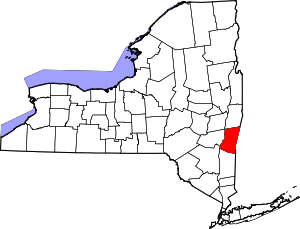 | |
| Towns | ||
| Villages | ||
| CDPs | ||
| Other hamlets | ||
| Footnotes | ‡This populated place also has portions in an adjacent county or counties | |