Karuah, New South Wales
| Karuah New South Wales | |||||||||||||
|---|---|---|---|---|---|---|---|---|---|---|---|---|---|
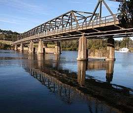 Bridge over the Karuah River | |||||||||||||
|
Karuah | |||||||||||||
| Coordinates | 32°38′35″S 151°57′26″E / 32.64306°S 151.95722°ECoordinates: 32°38′35″S 151°57′26″E / 32.64306°S 151.95722°E | ||||||||||||
| Population | 1,327 (2011 census)[1][Note 1] | ||||||||||||
| • Density | 13.8/km2 (36/sq mi) [Note 2] | ||||||||||||
| Postcode(s) | 2324 | ||||||||||||
| Area | 73.7 km2 (28.5 sq mi)[Note 3] | ||||||||||||
| Time zone | AEST (UTC+10) | ||||||||||||
| • Summer (DST) | AEDT (UTC+11) | ||||||||||||
| Location |
| ||||||||||||
| LGA(s) | |||||||||||||
| Region | Hunter[2] | ||||||||||||
| County | Gloucester[3][4] | ||||||||||||
| Parish | Tarean[3][4] | ||||||||||||
| State electorate(s) | Port Stephens | ||||||||||||
| Federal Division(s) | Paterson | ||||||||||||
| |||||||||||||
| |||||||||||||
Karuah is a locality[3] in both the Port Stephens and Mid-Coast Councils in the Hunter Region of New South Wales, Australia.[4][6] It is thought that the name means 'native plum tree' in the local Aboriginal dialect.[4][7]
Geography
Karuah is split between the Port Stephens and Mid-Coast councils with most (approximately 51%) located in the Port Stephens Council area. The village of Karuah is also split between the two councils with almost all of the village located in Port Stephens Council. The Karuah River, which runs approximately north to south through the centre of Karuah, forms the border between the two councils within the locality. Karuah is located at the north-western corner of Port Stephens into which the Karuah River feeds.[4][6]
Demographics
The largest settlement within the locality is the village of Karuah, which is on the old Pacific Highway and straddles the Karuah River. Most of the village, which occupies only about 0.7 square kilometres (0.3 sq mi) of the suburb's total area of 74.7 km2 (28.8 sq mi), lies within the Port Stephens LGA. It includes the largest Aboriginal community in the Port Stephens LGA and, at the 2006 Census, had a population of approximately 857.[8] The rest of the suburb's population live in the rural properties which surround the village.
The Karuah bridge was built and opened in December 1957.[9] In 2004, the Karuah Bypass was opened which, as part of the AusLink program, speeds up car and truck travel times past the township but left the town a backwater.
Karuah village has long been known for its oysters,[10] and a number of oyster shops line the old Pacific Highway within the town.
Notes
References
- ↑ Australian Bureau of Statistics (31 October 2012). "Karuah (State Suburb)". 2011 Census QuickStats. Retrieved 4 August 2012.
- ↑ "Suburb Search – Local Council Boundaries – Hunter (HT)". New South Wales Division of Local Government. Retrieved 27 May 2008.
- 1 2 3 "Karuah (Port Stephens)". Geographical Names Register (GNR) of NSW. Geographical Names Board of New South Wales. Retrieved 27 May 2008.
- 1 2 3 4 5 "Karuah (Great Lakes)". Geographical Names Register (GNR) of NSW. Geographical Names Board of New South Wales. Retrieved 27 May 2008.
- 1 2 3 "Raymond Terrace (Wallaroo State Forest)". Climate statistics for Australian locations. Bureau of Meteorology. Retrieved 6 June 2008.
- 1 2 "Karuah". Land and Property Management Authority - Spatial Information eXchange. New South Wales Land and Property Information. Retrieved 27 May 2008.
- ↑ "Karuah". Fairfax Digital. 8 February 2004. Retrieved 27 May 2008.
- ↑ Australian Bureau of Statistics (25 October 2007). "Karuah (State Suburb)". 2006 Census QuickStats. Retrieved 27 May 2008. Map
- ↑ Karuah Bridge
- ↑ Dow L, Guyon D, Irving R, McPhee M, Matthews A, Prineas P, Rubinich T, Simpson J (1995). Reader's Digest Illustrated Guide to Australian Places. Surry Hills, NSW: Reader's Digest. p. 68. ISBN 0-86438-399-1.
External links
![]() Media related to Karuah, New South Wales at Wikimedia Commons
Media related to Karuah, New South Wales at Wikimedia Commons