Gloucester, New South Wales
| Gloucester New South Wales | |
|---|---|
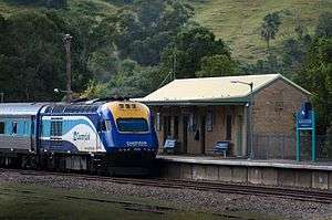 XPT departs Gloucester station | |
|
Gloucester | |
| Coordinates | 32°00′34″S 151°57′37″E / 32.00944°S 151.96028°ECoordinates: 32°00′34″S 151°57′37″E / 32.00944°S 151.96028°E |
| Population | 2,336 (2011 census)[1] |
| Established | 1855 |
| Postcode(s) | 2422 |
| Elevation | 111 m (364 ft)[2] |
| Location | |
| LGA(s) | Mid-Coast Council |
| State electorate(s) | Upper Hunter |
| Federal Division(s) | Lyne |
Gloucester (![]() i/ˈɡlɒstər/ GLOS-tər), a town in dairy and beef cattle country, is located in Mid-Coast Council, within the Manning district on the Mid North Coast of the state of New South Wales, Australia.
i/ˈɡlɒstər/ GLOS-tər), a town in dairy and beef cattle country, is located in Mid-Coast Council, within the Manning district on the Mid North Coast of the state of New South Wales, Australia.
Gloucester is situated on the North Coast railway line and can be accessed from the southeast from Newcastle, located 145 kilometres (90 mi) via the Bucketts Way, or from the north via Thunderbolts Way. Gloucester River flows adjacent to the town, just above its junction with the Avon River.
At the 2011 census, Gloucester had a population of 2,336 people.[1]
History
The Gloucester district was first visited by Robert Dawson, Chief Agent for the Australian Agricultural Company in 1826. Settlement occurred in the 1830s. The township of Gloucester was first established in 1855, primarily for sheep farming, however it became apparent that the land was not entirely suitable. The four main industries of the Gloucester area are: tourism, timber, cattle farming and more. The timber industry has been prevalent in Gloucester since the late 19th century, and it and cattle farming are still major industries in and around Gloucester; both dairy and beef cattle.[3]
In 1876, gold was discovered in Copeland, a small town north-west of Gloucester. Copeland became a large town of over 3,000 inhabitants due to the gold discovery and the large number of red cedar trees. However, the population has since dwindled to a population of a few hundred.[4]
The Australian Agricultural Company was originally awarded mineral rights to 500,000 acres (200,000 ha) between the Karuah River and the Manning River which covered the Gloucester district. The company employed surveyors in 1856-7 to undertake a trial survey for a railway between Port Stephens and Stroud and further north to the Manning River, passing what became Gloucester. At the time it was felt that with the "formidable obstructions" from ranges and rivers, a railway line would be impracticable and construction did not proceed, and coal mining was abandoned before it had commenced.[3]
In 1923, electricity came to Gloucester, New South Wales, The Gloucester Electric Supply Company Ltd. was formed by Fred Lowe. He was called to Gloucester by a syndicate (mainly of local graziers) to assist in the development of a Gloucester electric supply. He presented plans for a ‘turn key’ installation of the complete plant which was accepted by the syndicate. The shareholders in the new company were Fred Lowe and his brother Ernest Lowe, who jointly held the great majority of the shares, and a number of local people. There were many ups and downs, especially during 1929, the depression. In the middle 1930s, the State Government was offering subsidies for the construction of rural lines. The first rural line was along the Buckets Road and this was opened on 9 September 1938. Fred Lowe designed and surveyed the line exercising his expertise in surveying which he acquired whilst working in New Zealand as a young man. In 1943 the company’s 20 year franchise ended. However it was wartime and the Mid-Coast Council Council did not exercise its right to acquire the company’s assets and take over the electricity undertaking till 1 July 1946. Fred Lowe was employed by the council as its electrical engineer. He still persisted with rural line extensions and completed the Avon Valley line taking electricity to Stratford. He remained as council electrical engineer until he retired in 1951. At a farewell function the Shire President, Cr. J.N. Channon, said, "We cannot let the opportunity pass without expressing our deep appreciation and gratitude to Mr Lowe for what he has done for Gloucester."
In 1995, Gloucester Coal, originally Stratford Coal, began mining in Stratford a small village 12 kilometres (7.5 mi) south of Gloucester, and has since spread throughout the region, possibly having acquired rights held by Australian Agricultural Company, as the mining activity is confined to their original boundaries.
In March 1972 the Governor of New South Wales, Sir Roden Cutler, VC and Lady Cutler toured the district and attended a formal Civic Reception at the Gloucester Bucketts Motel.
For most of the twentieth century it boasted two cinemas in the main thoroughfare - Church Street: The Star (opposite Permewans, closed c1968), and the Majestic Theatre, that was built in the early 1920s. The Majestic permanently closed its doors circa 1980 and the building still stands, now redeveloped as a shopping arcade.
The district's weekly newspaper is the The Gloucester Advocate.
Gallery
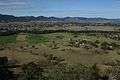 A view of the town of Gloucester, the Gloucester River, and Gloucester Valley, from Bucketts Tops, 2013.
 The Bucketts Range, Gloucester, 2008.
.jpg) Dairy farming in the Gloucester Valley, 1908. Photo courtesy of the NSW State Records Authority.
Dairy farming in the Gloucester Valley, 1908. Photo courtesy of the NSW State Records Authority.
References
- 1 2 Australian Bureau of Statistics (31 October 2012). "Gloucester (Urban Centre and Locality)". 2011 Census QuickStats. Retrieved 16 March 2013.
- 1 2 "Map of Gloucester, NSW". Bonzle Digital Atlas of Australia. Retrieved 16 March 2013.
- 1 2 Webber, J; Wylie, R. F (March 1968). "Colliery Railways of the Australian Agricultural Company". Australian Railway Historical Society Bulletin. New. XIX (365).
- ↑ Australian Bureau of Statistics (31 October 2012). "Barrington (State Suburb)". 2011 Census QuickStats. Retrieved 16 March 2013.