Gloucester River
| Gloucester River | |
| Perennial river[1] | |
 Upper reaches of the Gloucester River, at Gloucester Falls, within Barrington Tops National Park, 1997. | |
| Country | Australia |
|---|---|
| State | New South Wales |
| IBRA | NSW North Coast |
| District | Upper Hunter |
| Local government area | Dungog, Mid-Coast Council |
| Part of | Manning River catchment |
| Tributaries | |
| - left | Barrington River, Bowman River |
| - right | Berrico Creek, Buggs Creek, Sandy Creek (Upper Hunter, New South Wales), Avon River |
| Town | Gloucester |
| Landmark | The Bucketts |
| Source | Gloucester Tops, Great Dividing Range |
| - location | north northwest of Dungog |
| - elevation | 1,190 m (3,904 ft) |
| Mouth | confluence with the Manning River |
| - location | west of Wingham |
| - elevation | 38 m (125 ft) |
| Length | 102 km (63 mi) |
| National park | Barrington Tops |
| Waterfall | Gloucester Falls |
| [2] | |
Gloucester River (![]() i/ˈɡlɒstər/ GLOS-tər), a perennial river and major tributary of the Manning River catchment, is located in the Upper Hunter district of New South Wales, Australia.
i/ˈɡlɒstər/ GLOS-tər), a perennial river and major tributary of the Manning River catchment, is located in the Upper Hunter district of New South Wales, Australia.
Course and features
Gloucester River rises within Gloucester Tops, on the eastern slopes of the Great Dividing Range, north northwest of Dungog, and flows generally east northeast, joined by six tributaries including the Avon, Barrington, and Bowman rivers, before reaching its confluence with the Manning River, west of Wingham. The river descends 1,150 metres (3,770 ft) over its 102 kilometres (63 mi) course.[2]
The headwaters of the river originate in the World Heritage Barrington Tops region, flowing through the Barrington Tops National Park comprising Antarctic Beech and Southern Sassafras high altitude rainforest. In the middle and lower reaches, the river flows through subtropical rainforest that includes Red Cedar and Rosewood trees.
See also
Gallery
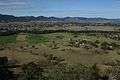 The Gloucester River meandering through the Gloucester Valley, viewed from Bucketts Tops, near the town of Gloucester, 2013.
.jpg) Cattle grazing on the banks of the Gloucester River, 1908. Photo courtesy of the NSW State Records Authority.
Cattle grazing on the banks of the Gloucester River, 1908. Photo courtesy of the NSW State Records Authority.
References
- ↑ "Gloucester River". Geographical Names Register (GNR) of NSW. Geographical Names Board of New South Wales. Retrieved 16 March 2013.
- 1 2 "Map of Gloucester River, NSW". Bonzle Digital Atlas of Australia. Retrieved 16 March 2013.
External links
- "Manning River catchments" (map). Office of Environment and Heritage. Government of New South Wales.
- "Gloucester Tops circuit". Barrington Tops National Park. NSW National Parks & Wildlife Service. Retrieved 16 March 2013.
- "Gloucester Falls walking track". Barrington Tops National Park. NSW National Parks & Wildlife Service. Retrieved 16 March 2013.
- "Gloucester River camping area (eastern section)". Campsites: NSW: Hunter Valley & Coast: Barrington Tops National Park. Explore Australia Publishing. 2010. Retrieved 16 March 2013.
- "Bucketts Walk & Drive". Sports & Recreation. Mid-Coast Council Council. 2011. Retrieved 16 March 2013.
River systems and rivers of Hunter-Central Rivers catchment, New South Wales, Australia | |||||||
|---|---|---|---|---|---|---|---|
| |||||||
| |||||||
| |||||||
|
Coordinates: 31°58′S 151°59′E / 31.967°S 151.983°E