Tanilba Bay, New South Wales
| Tanilba Bay New South Wales | |||||||||||||
|---|---|---|---|---|---|---|---|---|---|---|---|---|---|
 The distinctive entrance to Tanilba Bay from Lemon Tree Passage Road | |||||||||||||
|
Tanilba Bay | |||||||||||||
| Coordinates | 32°44′14″S 151°59′54″E / 32.73722°S 151.99833°ECoordinates: 32°44′14″S 151°59′54″E / 32.73722°S 151.99833°E | ||||||||||||
| Population | 2,921 (2011 census)[1] | ||||||||||||
| • Density | 224.7/km2 (582/sq mi) [Note 1] | ||||||||||||
| Established | 1831 | ||||||||||||
| Postcode(s) | 2319 | ||||||||||||
| Elevation | 3 m (10 ft)[Note 2] | ||||||||||||
| Area | 13 km2 (5.0 sq mi)[Note 3] | ||||||||||||
| Time zone | AEST (UTC+10) | ||||||||||||
| • Summer (DST) | AEDT (UTC+11) | ||||||||||||
| Location |
| ||||||||||||
| LGA(s) | Port Stephens Council[3] | ||||||||||||
| Region | Hunter[3] | ||||||||||||
| County | Gloucester[4] | ||||||||||||
| Parish | Sutton[4] | ||||||||||||
| State electorate(s) | Port Stephens[5] | ||||||||||||
| Federal Division(s) | Paterson[6] | ||||||||||||
| |||||||||||||
| |||||||||||||
Tanilba Bay is a suburb of the Port Stephens local government area in the Hunter Region of New South Wales, Australia.[3][4] It is located on the Tilligerry Peninsula adjacent to the bay from which it got its name.[2][8] "Tanilba" is said to mean "place of white flowers" in a local Indigenous language, presumably a reference to the flannel flowers which formerly thrived in the area.[9] At the 2011 census Tanilba Bay had a population of 2,921.[1]
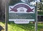
Tanilba House
The centrepiece of this small town is Tanilba House which is one of Australia's oldest buildings. In 1831 Lieut William Caswell, Royal Navy, received a land grant of 20.2 hectares (50 acres), along with an assignment of convicts who cleared the land and built Tanilba House from locally quarried stone.[10] Ten acres (4 hectares) on the eastern side of the hill was used as a vineyard soon after the house was built. An olive tree planted in the vineyard survives to this day.
In 1931 Tanilba House was owned by Henry Halloran who designed such structures as "The Temple", which is behind Tanilba House on the road leading to the house, and the elaborate gates at what were then the north and south entrances to the town. Today the town has expanded and the still incomplete gates stand inside the town limits. Tanilba House is surrounded by houses.
It was proposed that the Prime Minister of Australia would live here until Canberra was settled.


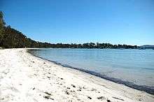
The main beach
The main beach in Tanilba Bay is located on the southern side of Port Stephens and runs from east to west. The eastern part of the beach accessed along a board walk with steps down to small inlets that provide access to the beach under the protection of native trees that a known for their koala population. The centre and western parts of the beach are flanked by various picnic areas and parks and boat ramps with the western most end having a wide stretch of sandy beach. At very low tide the sandy flats are exposed and on occasions during the high tide the water covers all the sand. The bay is protected from southerly winds which makes it a popular place for water sports such as skiing.
Notes
- ↑ This is the average density of the whole suburb. However, approximately 11.1 km2 (4.3 sq mi) (85.4%) of the suburb is uninhabited or consists of non-residential zones at the edge of the suburb and the average population density in the inhabited portion of the suburb is much higher at approximately 1,537/km2 (3,980/sq mi).
- ↑ Elevation data as shown on 1:100000 map 9232 NEWCASTLE and 1:25000 map 93324S PORT STEPHENS.
- ↑ Area calculation is based on 1:100000 map 9232 NEWCASTLE. The area presented is that of the whole suburb. The residential portion of the suburb is only 1.9 km2 (0.7 sq mi) or 14.6% of the total area.[2]
References
- 1 2 Australian Bureau of Statistics (31 October 2012). "Tanilba Bay (State Suburb)". 2011 Census QuickStats. Retrieved 20 October 2012.
- 1 2 "Tanilba Bay". Land and Property Management Authority - Spatial Information eXchange. New South Wales Land and Property Information. Retrieved 15 June 2008.
- 1 2 3 "Suburb Search - Local Council Boundaries - Hunter (HT) - Port Stephens". New South Wales Division of Local Government. Retrieved 15 June 2008.
- 1 2 3 "Tanilba Bay (suburb)". Geographical Names Register (GNR) of NSW. Geographical Names Board of New South Wales. Retrieved 15 June 2008.
- ↑ "Port Stephens". New South Wales Electoral Commission. 24 March 2007. Retrieved 15 June 2008.
- ↑ "Paterson". Australian Electoral Commission. 19 October 2007. Retrieved 15 June 2008.
- 1 2 3 "Nelson Bay (Nelson Head)". Climate statistics for Australian locations. Bureau of Meteorology. Retrieved 15 June 2008.
- ↑ "Tanilba Bay (bay)". Geographical Names Register (GNR) of NSW. Geographical Names Board of New South Wales. Retrieved 15 June 2008.
- ↑ "Tanilba Bay". Port Stephens Council website. Port Stephens Council. 3 November 2006. Archived from the original on 17 February 2008. Retrieved 15 June 2008.
- ↑ "Tanilba House". Port Stephens Council. 15 June 2008.
External links
| Wikimedia Commons has media related to Tanilba Bay, New South Wales. |
- "Tanilba Bay". Australian Explorer. Retrieved 15 June 2008.
- "Current Weather Conditions at Tanilba Bay, N.S.W.". Alan Gibson VK2CZZ. Retrieved 15 June 2008.