Angels Camp, California
| Angels Camp, California Angels | |
|---|---|
| City | |
|
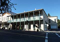
Downtown Angels Camp | |
| Nickname(s): Angels City, City of Angels | |
| Motto: "Redefining The Rush" | |
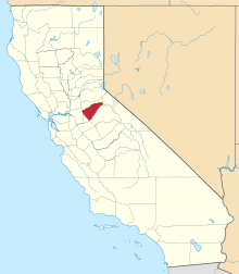
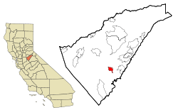 Location in Calaveras County and California | |
 Angels Camp, California Location in the United States | |
| Coordinates: 38°04′06″N 120°32′23″W / 38.06833°N 120.53972°WCoordinates: 38°04′06″N 120°32′23″W / 38.06833°N 120.53972°W | |
| Country |
|
| State |
|
| County | Calaveras |
| Mining camp | 1848[1] |
| Incorporated | January 24, 1912[2] |
| Government | |
| • Mayor | Wes Kulm[3] |
| • Vice Mayor | Jack Lynch[3] |
| • City Administrator | Michael McHattan[3] |
| Area[4] | |
| • Total | 3.637 sq mi (9.421 km2) |
| • Land | 3.628 sq mi (9.397 km2) |
| • Water | 0.009 sq mi (0.024 km2) 0.25% |
| Elevation[5] | 1,378 ft (420 m) |
| Population (2010) | |
| • Total | 3,836 |
| • Density | 1,100/sq mi (410/km2) |
| Time zone | PST (UTC-8) |
| • Summer (DST) | PDT (UTC-7) |
| ZIP code | 95222 |
| Area code(s) | 209 |
| FIPS code | 06-02112 |
| GNIS feature IDs | 1667877, 2409709 |
| Website |
www |
| Reference no. | 287[6] |

Angels Camp, also known as City of Angels and formerly Angel's Camp, Angels, Angels City, Carson's Creek and Clearlake, is the only incorporated city in Calaveras County, California, United States. The population was 3,835 at the 2010 census, up from 3,004 at the 2000 census. It lies at an elevation of 1378 feet (420 m).
Mark Twain based his short story "The Celebrated Jumping Frog of Calaveras County" on a story he claimed he heard at the Angels Hotel in 1865.[7] The event is commemorated with a Jumping Frog Jubilee each May at the Calaveras County Fairgrounds, just east of the city. Because of this, Angels Camp is sometimes referred to as "Frogtown."
The city is California Historical Landmark #287.[6]
History
Henry Angell, a native of Rhode Island, set up a tent store on the banks of the creek. The placers around his camp were productive but gave out after a few years, and the population began to dwindle until gold-bearing quartz veins were discovered in the town, which brought people back. Those mines operated for the next few decades, producing more than $20 million worth of gold, processed by stamp mills in town. It was said that when the last mill finally ceased operations, the townspeople couldn't sleep, the silence was so loud.[1]
The first post office was established in 1851 (and called Carson's Creek). It was renamed along with the town in 1853. The city was incorporated under the name of "Angels" in 1912.[8]
Geography
Angels Camp is located at 38°04′06″N 120°32′23″W / 38.06833°N 120.53972°W.
According to the United States Census Bureau, the city has a total area of 3.6 square miles (9.3 km2), all land.
Angels Camp is about 1,400 feet (430 m) above sea level, with Angels Creek flowing through the middle of town.
Climate
According to the Köppen Climate Classification system, Angels Camp has a warm-summer Mediterranean climate, abbreviated "Csa" on climate maps.[9]
Demographics
| Historical population | |||
|---|---|---|---|
| Census | Pop. | %± | |
| 1880 | 330 | — | |
| 1890 | 917 | 177.9% | |
| 1920 | 941 | — | |
| 1930 | 915 | −2.8% | |
| 1940 | 1,163 | 27.1% | |
| 1950 | 1,147 | −1.4% | |
| 1960 | 1,121 | −2.3% | |
| 1970 | 1,710 | 52.5% | |
| 1980 | 2,302 | 34.6% | |
| 1990 | 2,409 | 4.6% | |
| 2000 | 3,004 | 24.7% | |
| 2010 | 3,836 | 27.7% | |
| Est. 2015 | 3,767 | [10] | −1.8% |
2010
The 2010 United States Census[12] reported that Angels Camp had a population of 3,836. The population density was 1,054.6 people per square mile (407.2/km²). The racial makeup of Angels Camp was 3,329 (86.8%) White, 12 (0.3%) African American, 48 (1.3%) Native American, 49 (1.3%) Asian, 5 (0.1%) Pacific Islander, 270 (7.0%) from other races, and 123 (3.2%) from two or more races. Hispanic or Latino of any race were 498 persons (13.0%).
The Census Bureau said 3,789 people (98.8% of the population) lived in households, 47 (1.2%) lived in non-institutionalized group quarters and 0 (0%) were institutionalized.
There were 1,645 households, out of which 422 (25.7%) had children younger than 18 living in them, 836 (50.8%) were opposite-sex married couples living together, 152 (9.2%) had a female householder with no husband present, 74 (4.5%) had a male householder with no wife present. There were 94 (5.7%) unmarried opposite-sex partnerships, and nine (0.5%) same-sex married couples or partnerships. A total of 489 households (29.7%) were made up of individuals and 252 (15.3%) had someone living alone who was 65 or older. The average household size was 2.30. There were 1,062 families (64.6% of all households); the average family size was 2.81.
The population was spread out with 794 people (20.7%) younger than 18, 273 people (7.1%) aged 18 to 24, 810 people (21.1%) aged 25 to 44, 1,086 people (28.3%) aged 45 to 64, and 873 people (22.8%) who were 65 or older. The median age was 45.9 years. For every 100 females there were 93.3 males. For every 100 females age 18 and older, there were 90.5 males.
There were 1,943 housing units at an average density of 534.2 per square mile (206.3/km²), of which 1,060 (64.4%) were owner-occupied and 585 (35.6%) were occupied by renters. The homeowner vacancy rate was 3.2%; the rental vacancy rate was 10.7%. A total of 2,355 people (61.4% of the population) lived in owner-occupied housing units and 1,434 people (37.4%)lived in rental housing units.
2000
As of the census[14] of 2000, there were 3,004 people, 1,286 households, and 856 families residing in the city. The population density was 993.6 people per square mile (384.1/km²). There were 1,422 housing units at an average density of 470.3 per square mile (181.8/km²). The racial makeup of the city was 93.14% White, 0.20% Black or African American, 1.83% Native American, 0.47% Asian, 0.03% Pacific Islander, 1.43% from other races, and 2.90% from two or more races. Hispanic or Latino of any race were 8.09% of the population.
There were 1,286 households, out of which 28.2% had children younger than 18 living with them, 49.3% were married couples living together, 12.3% had a female householder with no husband present and 33.4% were non-families. A total of 29.0% of all households were made up of individuals, and 13.4% had someone living alone who was 65 or older. The average household size was 2.34, and the average family size was 2.82.
In the city the population was spread out with 24.3% younger than 18, 6.7% from 18 to 24, 24.7% from 25 to 44, 26.1% from 45 to 64, and 18.2% who were 65 or older. The median age was 41 years. For every 100 females, there were 92.4 males. For every 100 females age 18 and older, there were 87.1 males.
The median income for a household in the city was $33,371, and the median income for a family was $48,125. Males had a median income of $37,269 vs. $27,778 for females. The per capita income for the city was $19,599. About 10.0% of families and 13.0% of the population were below the poverty line, including 15.2% of those younger than 18 and 10.0% of those age 65 or older.
Government
In the state legislature, Angels Camp is in the 8th Senate District, represented by Republican Tom Berryhill,[15] and the 5th Assembly District, represented by Republican Frank Bigelow.[16] Federally, Angels Camp is in California's 4th congressional district, represented by Republican Tom McClintock.[17]
Notable people
- Sara Carter, member of the musical group The Carter Family
- T.J. Dillashaw, Former UFC bantamweight champion[18]
- Mike McCormick, Major League Baseball player
- Catfish Metkovich, Major League Baseball player
- Kyle Rasmussen, United States Ski Team member and two-time Alpine skiing World Cup Downhill champion
| Wikimedia Commons has media related to Angels Camp, California. |
References
- 1 2 Koeppel, Elliot H. "Angels Camp". The California Gold Country: Highway 49 Revisited. Malakoff & Co. ISBN 0-938121-12-X.
- ↑ "California Cities by Incorporation Date". California Association of Local Agency Formation Commissions. Archived from the original (Word) on November 3, 2014. Retrieved March 27, 2013.
- 1 2 3 "City Officials and Staff". City of Angels Camp. Retrieved May 19, 2015.
- ↑ "2010 Census U.S. Gazetteer Files – Places – California". United States Census Bureau.
- ↑ "Angels Camp". Geographic Names Information System. United States Geological Survey. Retrieved October 20, 2014.
- 1 2 "Angels Camp". Office of Historic Preservation, California State Parks. Retrieved 2012-10-06.
- ↑ Northern California. Heathrow, Florida: AAA Publishing. 2012. p. 46.
- ↑ Durham, David L. (1998). California's Geographic Names: A Gazetteer of Historic and Modern Names of the State. Clovis, Calif.: Word Dancer Press. p. 740. ISBN 1-884995-14-4.
- ↑ Climate Summary for Angels Camp, California
- ↑ "Annual Estimates of the Resident Population for Incorporated Places: April 1, 2010 to July 1, 2015". Retrieved July 2, 2016.
- ↑ "Census of Population and Housing". Census.gov. Archived from the original on May 11, 2015. Retrieved June 4, 2015.
- ↑ "2010 Census Interactive Population Search: CA - Angels city". U.S. Census Bureau. Retrieved July 12, 2014.
- ↑ Angels 5 Theatre, Cinema Treasures, Accessed August 2, 2009.
- ↑ "American FactFinder". United States Census Bureau. Archived from the original on September 11, 2013. Retrieved 2008-01-31.
- ↑ "Senators". State of California. Retrieved March 21, 2013.
- ↑ "Members Assembly". State of California. Retrieved March 21, 2013.
- ↑ "California's 4th Congressional District - Representatives & District Map". Civic Impulse, LLC. Retrieved March 2, 2013.
- ↑ http://espn.go.com/mma/story/_/id/10979081/tj-dillashaw-clinches-135-pound-title-upsetting-barao
External links
| Wikivoyage has a travel guide for Angels Camp. |
- Official website
- Historic American Buildings Survey (HABS) No. CA-1499, "Angels Camp, General View, Main Street, Angels Camp, Calaveras County, CA"