A4042 road
| |
|---|---|
 | |
| Major junctions | |
| North end: | Abergavenny |
|
[[Image:Motorway Left.svg|[ |x30px|link=]] | |
| South end: | Newport |
| Location | |
| Primary destinations: | Cwmbran |
| Road network | |
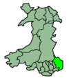
The A4042 is a trunk road that runs from Abergavenny to Newport in the United Kingdom.
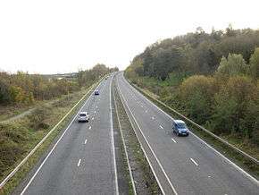
It begins on junction of the A40 and A465 south of Abergavenny and then travels southwards towards Little Mill north of Pontypool. This section is a single carriageway and is notoriously winding and undulating. From Little Mill onwards the road becomes a dual carriageway, passing Pontypool and Cwmbran before crossing the city boundary into Newport. Here the road has a junction (25A) with the M4 motorway and south from there loses its primary status and becomes an urban road. The first section of which, called Heidenheim Drive,[1] is an elevated roadway through the Crindau district. It then becomes a surface street called Kingsway that passes through the city centre, and continues on as Usk Way until its junction with the A48 Southern Distributor Road in the south of the city.
Junctions
| A4042 (T) | |||||
| Northbound exits | Junction | Southbound exits | |||
|---|---|---|---|---|---|
| Merthyr Tydfil, Hereford A465 Abergavenny, Brecon, Monmouth A40 |
Ysbytty Fields Roundabout | Start of A4042 (T) | |||
| Llanfoist B4269 | Llanellen Junction | Llanfoist B4269 | |||
| Usk A472 | Little Mill Junction | Usk, Little Mill A472 | |||
| Mamhilad | Mamhilad Roundabout | Mamhilad | |||
| New Inn | New Inn Roundabout | New Inn | |||
| Pontypool A472 (A4043) | Pontymoile Roundabout | Pontypool A472 (A4043) | |||
| Cwmbran A4051 New Inn |
Craig-y- Felin | New Inn Cwmbran A4051 | |||
| Croesyceiliog | Croesyceiliog Roundabout | Croesyceiliog | |||
| Croesyceiliog Caerleon B4236 |
Turnpike Roundabout | Caerleon B4236 | |||
| Llantarnam Cwmbran |
Crown Roundabout | Llantarnam Cwmbran | |||
| Cwmbran A4051 | Croes-y-Mwyalch | Cardiff A4051 (M4 (W)) | |||
| Start of A4042 (T) | Grove Park | London, Chepstow A4042 (M4 (E)) | |||
| A4042 | |||||
| Northbound exits | Junction / Interchange | Southbound exits | |||
| London, Chepstow A4042 (M4 (E)) Caerleon B4596 |
Grove Park | Start of A4042 | |||
| Cardiff A4051 (M4 (W)) | Harlequin | Cardiff A4051 (M4 (W)) City Centre | |||
| Civic Centre B4591 Exit only |
Old Green Interchange | Access only | |||
| Cattle market Old Town Docks |
Octopus Bridge | Old Town Docks Superstore | |||
| Start of A4042 | Old Town Dock | (M4 (E)), Pilgwenlly, Docks, (M4 (W)) A48 | |||
| 1.000 mi = 1.609 km; 1.000 km = 0.621 mi | |||||
See also
References
- ↑ Named after one of Newport's twin towns.
External links
-
 Media related to A4042 road (Wales) at Wikimedia Commons
Trunk Roads in Wales | ||
|---|---|---|
| Managed by the North and Mid Wales Trunk Road Agent |
|  |
| Managed by the South Wales Trunk Road Agent |
| |
| Related topics and further information | ||

Coordinates: 51°43′05″N 2°59′29″W / 51.71809°N 2.99137°W