A4232 road
| |
|---|---|
 | |
| Route information | |
| Maintained by South Wales Trunk Road Agent (Capel Llanilltern – Culverhouse Cross Link Road) and City of Cardiff Council (all other Link Roads) | |
| Length: | 12.2 mi (19.6 km) |
| Existed: | 1978[1] – present |
| History: | Constructed 1978–1995 |
| Major junctions | |
| West end: |
[[Image:Motorway Left.svg|[ |x30px|link=]] |
|
| |
| East end: |
[[Image:Motorway Left.svg|[ |x30px|link=]] |
| Location | |
| Primary destinations: | Cardiff |
| Road network | |
The A4232, which is also known either as the Peripheral Distributor Road (PDR) (Welsh: Ffordd Ddosbarthu Ymylol) or the Cardiff Link Road (Welsh: Ffordd Gyswllt Caerdydd),[2][3][4] is a distributor road in Cardiff, the capital of Wales.
The first section of the PDR to be completed was the Southern Way Link Road in 1978 and the last section was the Butetown Link Road in 1995. Construction of the first phase of the final link road, the Eastern Bay Link Road, started on 17 March 2016 and is due to be completed by April 2017. When fully completed, the road will form part of the Cardiff ring road system.[5] The PDR runs west, south and east of Cardiff, with the M4 between junction 30 and junction 33 completing the northern section. The PDR is dual carriageway for its entire length except for the East Moors Viaduct, which is a single carriageway.
The PDR has been constructed in separate link roads of between 1.61 km (1.00 mi) and 5.47 km (3.40 mi) around Cardiff and to date 22 kilometres (14 mi) including spurs have been opened to traffic, with plans for a further 5.53 km (3.44 mi).[6] It has 4 large viaducts (Ely Viaduct, Grangetown Viaduct, Taff Viaduct and the East Moors Viaduct), 1 tunnel (Queen's Gate Tunnel) and 2 spur roads (Cogan Spur and Central Link Road). The road also has many smaller bridges over or under most of the interchanges on the road. The entire length of the road has clearway restrictions on it.
History
The road was conceived in the early 1970s and planning began in the late 1970s, by South Glamorgan County Council. The road at that stage was planned to be completed by 1995 and would relieve Ely, Grangetown, Butetown and East Moors of through traffic and as a fast link to the national motorway network via the M4 and A48(M).[7] The first section of the PDR to be completed was the Southern Way Link Road between Newport Road (A4161 road) and the Eastern Avenue (A48 road) in 1978 and the last section of the PDR, the Butetown Link Road, was opened to the public in 1995.[1][2]
The former chairman of the South Glamorgan County Council environment committee, Councillor Paddy Kitson, called the road a "necklace of opportunity" due to its shape and also the opportunities for regeneration.[1] By 1 April 1996 the responsibility for the road was transferred from South Glamorgan County Council to the unitary authority of Cardiff Council. Much of the funding for the road had been grant aided from the European Community and the UK Government on the basis that it would improve the economic viability of the area and bring in new jobs and industry.[1] However, since the completion of the Butetown Link Road, funding for further developments have been at a stand still,[2] and to date 22 kilometres (14 mi) including spurs are open to traffic with plans for a further 5.53 km (3.44 mi).[6] The "missing link", the Eastern Bay Link Road, is still to be built.[2]
Route description
The PDR has 3 separate sections; the Capel Llanilltern Interchange (M4 J33) to Queen's Gate roundabout, the Rover Way – Lamby Way roundabout to the Llanedeyrn Interchange (A48) and the Pontprennau Interchange (A48) to the Pentwyn Interchange (M4 J30).
The section from the Capel Llanilltern Interchange on the M4 (junction 33) to the Queen's Gate roundabout is sometimes referred to as the Western Link Road (Welsh: Ffordd Gyswllt Gorllewin),[8] is 15.77 kilometers (9.80 mi) in length and includes the Capel Llanilltern – Culverhouse Cross Link Road, Ely Link Road, Grangetown Link Road and Butetown Link Road. For the majority of this section it is the boundary between the City of Cardiff to the east and the Vale of Glamorgan to the west.
| A4232 | |||||
| Clockwise exits | Junction / Interchange | Anti-Clockwise exits | |||
|---|---|---|---|---|---|
| Bridgend, Newport, M4 Exit only |
M4 J33 Capel Llanilltern Interchange Cardiff West services |
Start of A4232 | |||
| No access or exit | St. Fagans | Museum of Welsh Life | |||
| Start of A4232 | Culverhouse Cross | A48 (W) Ely, Cardiff West A48 (E) Cowbridge/Y Bont Faen A4050 Cardiff Airport/Maes Awyr Caerdydd, Barry/Y Barri | |||
| A4232 | |||||
| Clockwise exits | Junction / Interchange | Anti-Clockwise exits | |||
| A48 (W) Cardiff West A48 (E) Cowbridge/Y Bont Faen A4050 Cardiff Airport/Maes Awyr Caerdydd, Barry/Y Barri |
Culverhouse Cross | Start of A4232 | |||
| B4267, City Centre | Leckwith | B4267, City Centre, Hadfield Road | |||
| A4055, Barry, Penarth, Grangetown | Ferry Road | A4055, Barry, Penarth, Grangetown | |||
| No Exit | Stuart Street | Techniquest Museum, Mermaid Quay Exit Only | |||
| Start of A4232 | Queen's Gate roundabout (Road terminates at roundabout) |
A4234, City Centre, Docks End of A4232 | |||
| Eastern Bay Link Road | |||||
1.000 mi = 1.609 km; 1.000 km = 0.621 mi
| |||||
This section partly opened in 1978,[1] from the Rover Way – Lamby Way roundabout to the Llanedeyrn Interchange on the A48 is oldest section of the PDR. It includes only the Southern Way Link Road, known locally as Southern Way, and is 2.25 km (1.40 mi) in length.
| A4232 | |||||
| Clockwise exits | Junction / Interchange | Anti-Clockwise exits | |||
|---|---|---|---|---|---|
| Lamby Way End of A4232 |
Rover Way / Lamby Way | Start of A4232 | |||
| A4161, City centre Exit only |
Southern Way | Access only | |||
| Start of A4232 | Llanedeyrn | A48, Newport, City Centre End of A4232 | |||
| A48 | |||||
1.000 mi = 1.609 km; 1.000 km = 0.621 mi
| |||||
The Pentwyn Link Road section from the Pontprennau Interchange on the A48 to the Pentwyn Interchange on the M4 (junction 30) is one of the newer sections of the PDR, having been opened in 1984, it is 1.61 km (1.00 mi) in length. The road between the Llanedeyrn Interchange to the Pontprennau Interchange is the A48 (Eastern Avenue), it too is a dual carriageway and is a concurrent road with the PDR, there are no plans to renumber this section of the A48.
| A4232 | |||||
| Clockwise exits | Junction / Interchange | Anti-Clockwise exits | |||
|---|---|---|---|---|---|
| A48 | |||||
| A48 | A48 Pontprennau | Start of A4232 | |||
| Pontprennau, Cardiff Gate Retail Park, Llanedeyrn Village |
Heol Pontprennau | Pontprennau, Cardiff Gate Retail Park, Llanedeyrn Village | |||
| Start of A4232 | M4 J30 Pentwyn Interchange Cardiff Gate services |
Bridgend, Newport, M4 End of A4232 | |||
1.000 mi = 1.609 km; 1.000 km = 0.621 mi
| |||||
Link roads
A map of all the link roads and spur roads can be seen by clicking Map of all coordinates opposite
Each section of the road was completed in separate link roads.
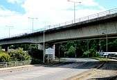
Capel Llanilltern – Culverhouse Cross Link Road
.jpg)

The GB£14.5 million Capel Llanilltern – Culverhouse Cross Link Road (Welsh: Ffordd Gyswllt Capel Llanilltern – Croes Cwrlwys), also known as the A4232 Trunk Road (as it is the only section of the PDR which is a trunk road), between the Capel Llanilltern Interchange (51°30′23″N 3°18′38″W / 51.506481°N 3.310425°W) and the Culverhouse Cross Interchange (51°27′59″N 3°16′16″W / 51.466350°N 3.271110°W) was opened in 1985.[6] It was designed to provide a by-pass for traffic from the M4 to the Vale of Glamorgan.[6] It is 5.47 km (3.40 mi) in length and includes the Ely Viaduct close to Michaelston-super-Ely. The trunk road is maintained by the South Wales Trunk Road Agency (SWTRA) on behalf of the Welsh Assembly Government (WAG).[9] The remainder of the PDR is a primary route, which is maintained by Cardiff Council. In 2006 variable message signs were installed on the Capel Llanilltern – Culverhouse Cross Link Road by Techspan Systems to display messages giving motorists warning of road and weather conditions, accidents, congestion and major events held in the area.[10][11]
Ely Viaduct
The Ely Viaduct (Welsh: Traphont Trelái) crosses over the River Ely and also the main South Wales railway line.
The viaduct is a 538 ft (164 m) twin-box girder and has central span of 230 ft (70 m) and 150 ft (46 m) side spans, constructed by the balanced cantilever method. It was constructed in segments each weighing between 54 tons for plain segments to 93 tons for the main segments.[12]
Ely Link Road

The Ely Link Road (Welsh: Ffordd Gyswllt Trelái) between the Culverhouse Cross Interchange (51°27′57″N 3°16′12″W / 51.465840°N 3.269895°W) and the Leckwith Interchange (51°28′14″N 3°12′42″W / 51.470641°N 3.211762°W), sometimes referred to as the Leckwith Road Interchange. It is 4.83 km (3.00 mi) in length and was opened in 1982 and built by Davies Middleton & Davies Ltd (DMD).[13] It was designed to relieve Ely of through traffic and partly cuts into Leckwith Hill.[6]
Grangetown Link Road
.jpg)

The 2.89 km (1.80 mi) Grangetown Link Road (Welsh: Ffordd Gyswllt Trelluest) between the Leckwith Interchange (51°28′13″N 3°12′40″W / 51.470159°N 3.211239°W) and the Ferry Road Interchange (51°27′13″N 3°11′09″W / 51.453510°N 3.185760°W) was opened on 3 May, 1988.[14] It includes the Grangetown Viaduct.
Grangetown Viaduct
The Grangetown Viaduct (Welsh: Traphont Trelluest) is approximately 1 km (0.62 mi) in length and is said to be the longest glued segmental bridge in the United Kingdom.[15] It has 13 spans of 71 meters (233 ft) with 2 end spans of 38 m (125 ft) and 46 m (151 ft).[16]
The viaduct was designed by South Glamorgan County Council. Robert Benaim and Associates, now called Benaim UK Ltd designed the initial launching system for the glued segmental structure.
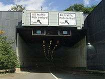
Butetown Link Road
Butetown Tunnel

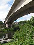
The 2.57 km (1.60 mi) Butetown Link Road (Welsh: Ffordd Gyswllt Butetown) between the Ferry Road Interchange (51°27′13″N 3°11′03″W / 51.453585°N 3.184044°W) and the Queen's Gate Roundabout (51°28′04″N 3°09′27″W / 51.467873°N 3.157455°W) was opened on 27 March, 1995 by Neil Kinnock at the time the European Commissioner for Transport.[14] Construction of the link road commenced on 15 October 1993 and it was the last link road to be built. It includes the Taff Viaduct, also known as the Butetown Link Road Bridge, and the Queen's Gate Tunnel, which is also known simply as the Butetown Tunnel.
In 1987 South Glamorgan County Council had intended to build a viaduct cross the River Taff and then go onto an elevated section through Butetown "on stilts".[7] But the newly formed Cardiff Bay Development Corporation along with local residents objected to the scheme that they said would cut through Butetown and split the community, creating an unnecessary physical barrier between the two areas to the north and south of the link road. By 1988 South Glamorgan County Council had agreed to change the design of the link road, despite having already spent 6 years of design work on the link road meant that a tunnel had to be built instead.[17] The cost of the Butetown Link Road was estimated to cost £35 million, but this had risen to £45M in 1988, before the design change.[18]
The contract to build the Butetown Link Road was eventually won by a local company Davies Middleton & Davies Ltd in a joint venture with an Italian contractor, Cogefar-Impresit UK Ltd. The bid of £60 million undercut all other bids by £10 million,[19] Davies Middleton & Davies Ltd have subsequently gone into administrative receivership.
Queen's Gate Tunnel

The Queen's Gate Tunnel (Welsh: Twnnel Porth y Frenhines), also known as the Butetown Tunnel, is underneath southern Butetown and follows a line underneath the Wales Millennium Centre. The 715 m (2,346 ft)[20] twin tunnel was constructed using the cut and cover method of construction, which involves digging a trench for the tunnel and then roofing it over. The tunnel was constructed using reinforced concrete and a central wall separates the two sets of traffic.[21]
South Glamorgan County Council originally awarded the contract for the management, installation, testing and commissioning of all electrical and mechanical services for the tunnel, and the water pumping stations to EI·WHS Ltd. They still maintain the tunnel on behalf of Cardiff Council.[20]
Taff Viaduct


Construction of the 600 m (2,000 ft) Taff Viaduct (Welsh: Traphont Tâf) includes a dual-carriageway roadway plus a foot and cycle path. South Glamorgan County Council was the local authority in charge of the project at the time and construction of the viaduct began in March, 1991. The Taff Viaduct crosses the River Taff at Cardiff Bay.
The viaduct was constructed using precast concrete segments, which is widely used in the construction industry for medium to long span viaducts. Segments were made in a casting yard near the site and then transported for final assembly of the viaduct.[22]
Eastern Bay Link Road
_map.png)
Construction began on 17 March 2016 on the 5.25 km (3.26 mi) Eastern Bay Link Road (Welsh: Ffordd Gyswllt Ddwyreiniol y Bae) which will run from the Queen's Gate Roundabout to the Rover Way – Lamby Way Roundabout on the Southern Way Link Road, although at present only the first phase between Queen's Gate Roundabout (51°28′05″N 3°09′22″W / 51.468090°N 3.156193°W) and Ocean Way Interchange.[23] (51°28′20″N 3°08′39″W / 51.472328°N 3.144107°W) The link road will be a two lane dual carriageway with a 50 miles per hour (80 km/h) speed limit.[24][25]
For many years this link road has been mothballed due to the costs involved.[26] The link road had previously been known as the East Moors Link Road – Phase 1 and 3, but it also included the East Moors Viaduct, which was originally known as the East Moors Link Road – Phase 2.[1] Later it became known as the Cardiff Bay Link Road, then renamed the Eastern Bay Link Road.[7]

The Eastern Bay Link Road, along with other schemes have been subject to many planning proposals since the last link road (the Butetown Link Road) was finished in 1995, namely a local transport plan (Local Transport Plan 2000–2016) in August 2000, a green paper (A Change of Gear) in December 2002 and a white paper (Keeping Cardiff Moving) in May 2003.[6][27] The cost of the link road was estimated to cost GB£162 million in 2001 and this increased to GB£180 million by August 2002. It could be paid for by congestion charging,[28] although a public-private partnership is also possible.[29]
The original route of the link road had been challenged by both Friends of the Earth Cymru,[30] and also the Royal Society for the Protection of Birds (RSPB), who had both lodged formal objections against the link road.[31] However, the current proposal from Cardiff Council of 31 October 2006 is to complete the first phase of the road, approximately 1 km (0.62 mi) in length, from the Butetown Link Road to Ocean Way roundabout. The new route would be a different route from the earlier proposal and would avoid any encroachment into the nature conservation area, which Friends of the Earth and the RSPB had objected to. Therefore, the new route of the link road should ensure that there are no objections.[32][33]


It was revealed on 14 June 2013 that Edwina Hart, Minister for Economy, Science and Transport in the WAG supported the completion the Eastern Bay Link Road.[34] She said that the link road would; improve access to Cardiff Bay, improve access to the Cardiff Central Enterprise Zone and enhance connections within the Cardiff City Region.[35] The overall objectives of the road would be to:
- Increase accessibility from east Cardiff to major employment sites in the East Moors area, Cardiff Bay and the Central Cardiff Enterprise Zone
- Provide a more direct route between the Butetown Tunnel and Rover Way
- Reduce congestion at the junctions on Tyndall Street by removing traffic currently using the Ocean Way- East Tyndall Street – Central Link route
- Reduce journey times for private and commercial road users
- Help economic regeneration
- Enhance road safety and reduce casualties
- Improve resilience on the strategic road network around Cardiff
- Provide more opportunities for cycling and walking[35]
On 2 May 2014, Edwina Hart approved the procurement of the design–build contractor, advance service diversion works and communications arrangements for the Eastern Bay Link Road.[36] Construction of this first phase of the Eastern Bay Link Road is due to begin in 2015 and will take 18 months to complete.[25] In April 2015, it was announced by the Welsh Government that the 1.2 km £27.3m Eastern Bay Link Road from the incomplete flyover at the Queens Gate roundabout to the Ocean Way roundabout at Tremorfa known as the "roundabout to nowhere", would be designed by Capita Property and Infrastructure and constructed by Dawnus Construction Holdings and Ferrovial Agroman UK in a joint venture.[25][37] Construction began on the link road on 17 March 2016.[23]
Southern Way Link Road
Southern Way Flyover


The Southern Way Link Road (Welsh: Ffordd Gyswllt y Ffordd Deheuol),[38] generally known simply as Southern Way, was built in two parts; the first section of Southern Way to be completed was between Newport Road (A4161 road) and the Eastern Avenue (A48 road) in 1978.[1] The final section of the link road was built between Newport Road and the Rover Way – Lamby Way roundabout and was opened in 1984 at a cost of £9 million and includes the East Moors Viaduct, which is also known as the Southern Way Flyover.[1] In 1987 it was envisaged that the present single-carriage would be "twinned" as a dual-carriageway, the same as the rest of the PDR.[7] The 2.25 km (1.40 mi) link road now runs from the Rover Way – Lamby Way Roundabout (51°29′35″N 3°08′02″W / 51.493127°N 3.133759°W) to the Llanedeyrn Interchange (51°30′26″N 3°08′45″W / 51.507202°N 3.145853°W) on the A48.
East Moors Viaduct
The 900 m (3,000 ft) East Moors Viaduct (Welsh: Traphont Rhostiroedd y Dwyrain),[39] which is also known as the Southern Way Flyover, was also designed by Robert Benaim and Associates who won the ICE (Institution of Civil Engineers) Project Award and also a Concrete Society Commendation, both in 1985 for work on the viaduct.[40][41] The viaduct was constructed by concrete box girder deck of segmental construction.[40] The East Moors Viaduct was originally known as the East Moors Link Road – Phase 2,[1] but now forms part of the Southern Way Link Road.
Pentwyn Link Road

The Pentwyn Link Road (Welsh: Ffordd Gyswllt Pentwyn), which is also known as the North Pentwyn Link Road, runs from the Pontprennau Interchange (51°31′43″N 3°07′49″W / 51.528660°N 3.130240°W) on the A48 and the Pentwyn Interchange (51°32′29″N 3°07′43″W / 51.541525°N 3.128749°W) on the M4 (junction 30). It is 1.61 km (1.00 mi) in length and was opened by John Redwood MP, the Secretary of State for Wales on 20 June, 1994.[14] It provides a link between the Eastern Avenue (A48) and the M4 so that westbound traffic from the east of the city can get onto the M4 without having to go through the city, via the A48 and A470. In addition it also provides access to the community of Pontprennau to the national road network. This link was financed by private developers as part of a large scale housing development at Pontprennau.[42]
Public Art & Commemorative Stones
| Type | Image | Link Road | Location | Notes |
|---|---|---|---|---|
| Sculpture - A Private View |  |
Butetown Link Road | Taff Viaduct (western end) |
South Glamorgan County Council commissioned a sculpture by Kevin Atherton for the foot and cycle path on a specially constructed viewing platform. The work was to mark the completion of the Taff Viaduct so that the sculpture should be visible for the benefit of pedestrians, cyclist and motorists alike.[43] It was unveiled in 1995.[44] |
| Commemorative stone |  |
Butetown Link Road | Queen's Gate Roundabout | Stone marking the inauguration of Queen's Gate (Butetown Link Road) at the Queen's Gate roundabout on 15 October 1993. |
| Sculpture - Secret Station |  |
Southern Way Link Road | Rover Way roundabout (south west of roundabout) | A sculpture by Eilis O'Connell, unveiled 1992.[44] |
| Commemorative stone |  |
Pentwyn Link Road | Heol Pontprennau roundabout (south west of roundabout) |
Stone marking the opening of the Pentwyn Link Road on 20 June 1994. |
Spur roads
Cogan Spur (A4055)

The Cogan Spur, which is also known as the Cogan Link (Welsh: Gyswllt Cogan),[45] from the Ferry Road Interchange (51°27′13″N 3°11′06″W / 51.453519°N 3.184876°W) to Barons Court Junction (51°26′52″N 3°11′23″W / 51.447910°N 3.189787°W) on the A4160 was opened in 1988.[13] It is only 0.8 km (0.50 mi), but it is an important link to provide access to the PDR from Penarth and the southern part of the Vale of Glamorgan. It also bypasses Penarth Road (A4160) for traffic going in and out of Cardiff city centre.
The most recent development, which began at the end of 2006 and into 2007 was the widening of the road between the Cogan Viaduct and the Ferry Road Interchange to a 3-lane dual-carriageway. A new junction was also built for the Cardiff International Sports Village directly from Cogan Spur; also the Barons Court roundabout was replaced by a signal controlled crossroad. The main contractor for this project was Laing O'Rourke Civil Engineering.[45][46]
Cogan Viaduct
The Cogan Viaduct (Welsh: Traphont Cogan) is the most important element of the Cogan Spur as it crosses the River Ely with a central span of 95 metres (312 ft). In total it has 6 spans; 40 m (130 ft), 60 m (200 ft), 60 m, 60m, 95 m and 60 m.[16] It is made from a multi-span glued segmental structure of rectangular box sections. In all over 300 sections were used to construct the viaduct, each weighing from 43 to 117 tonnes.[22][47] The Cogan Viaduct was again designed by South Glamorgan County Council, who won a Concrete Society Commendation in 1989 for the design.
Central Link Road (A4234)

The £8.5 million Central Link (Welsh: Ffordd Gyswllt Canolog) between the Queen's Gate Roundabout (51°28′06″N 3°09′27″W / 51.468399°N 3.157366°W) and the junction on Adam Street (51°28′46″N 3°10′03″W / 51.479557°N 3.167631°W) on the A4160 was opened on 16 February 1989.[1][14] When it was first opened it only linked Cardiff city centre with Cardiff Bay. It was not until the Butetown Link was opened on 27 March 1995 that this road started to be used as a link to the motorway network, Penarth and the Vale of Glamorgan. It will not be until the Eastern Bay Link is built, when traffic from the city centre will use it to travel east, that it will be fully used. The length of the A4234 is just 1.45 km (0.90 mi) and is entirely a two lane dual carriageway with clearway restrictions.
Abandoned spur roads
Ely Spur

The Ely Spur was planned to run from a new interchange on the Ely Link Road to the Ely Bridge Roundabout on the A48. It was only 1.2 km (0.75 mi) in length, but it would have reduced through traffic in the residential area of Ely, namely on Cowbridge Road West traveling to and from the A48. But it has now been announced that this proposal has now been officially abandoned.[32]
Cardiff Airport Link Road

The Cardiff Airport Link Road (Welsh: Ffordd Gyswllt Maes Awyr Caerdydd) was a proposed spur road off of the A4232 through to Cardiff Airport, when plans for the road were scrapped by the WAG in June 2009.[48] The current single carriageway A4050 road, from Cardiff to Cardiff Airport is also the main road from Barry to Cardiff and is the main commuter route.
One of the 4 proposed schemes involved a new major highway route linking the Ely Link Road (PDR), south of the Culverhouse Cross Interchange, through to the A4226 north of Barry. The estimated cost of this scheme would have been £96m, including the widening of the A4232.[49]
Services

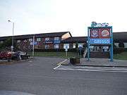
The PDR has two service stations for motorists, one at Cardiff West on the Capel Llanilltern Interchange and the other at Cardiff Gate on the Pentwyn Interchange. The services at Cardiff West includes Esso petrol, a Travelodge, Burger King, Costa Coffee and W H Smith,[50] while the services at Cardiff Gate includes Shell petrol, a Hotel Ibis, Burger King, KFC, Starbucks, Waitrose and W H Smith.[51]
Traffic Wales is the Welsh Government's traffic information service, it is a partnership between the Welsh Government, the two Trunk Road Agents (South Wales TRA / Norh & Mid Wales TRA) and the WTTC consultancy Amey. In South Wales the service is managed from the South Wales Traffic Management Centre, also home to INRIX Media's studio, providing live travel information for the media. The Traffic Wales website has five live traffic webcams on the Capel Llanilltern – Culverhouse Cross Link Road (Trunk Road) and the images are updated every 5 minutes. Traffic Wales also operates a Traffic Information Hotline, motorists can use this telephone service by dialling an 0845 number, which gives up to date traffic information and travel advice.
Traffic congestion
Since the western link roads were built, a number of major developments have been built, such as the Cardiff Bay Retail Park, IKEA, Celtic Gateway, Cardiff International Sports Village that includes the Cardiff International Pool, Cardiff International White Water and Cardiff Arena, which have all generated additional traffic at the Ferry Road Interchange. In addition, the Leckwith development, which includes Cardiff City Stadium, Cardiff International Sports Stadium and the Capital Retail Park with a new Asda supermarket, have also significantly increased traffic on the Leckwith Interchange.[8] At the Culverhouse Cross Interchange, older developments such as the Brooklands Retail Park, Wenvoe Retail Park and Valegate Retail Park, including Tesco and Marks & Spencer have also significantly increased congestion along with commuter traffic from the Vale of Glamorgan. From 1989 to 1997 there had been an increase in traffic of 78% and a further increase of 35% by 2016 is predicted by the Assembly.[49] The Vale of Glamorgan Council also expressed reservations about the new developments of the Cardiff International Sports Village and the Cardiff City Stadium, which includes the Capital Retail Park. On 18 October, 2006, the council requested that the WAG assess the existing traffic conditions and future growth in traffic on the network.[52]
Popular culture
The Queen's Gate Tunnel was featured in the first ever episode of Torchwood, called "Everything Changes" and was first broadcast by BBC Three on 22 October 2006.[53] The Grangetown Link was featured in the 2006 Christmas episode of Doctor Who called "The Runaway Bride".[54][55] It was first broadcast by BBC One on 25 December 2006.[54]
See also
Notes
- 1 2 3 4 5 6 7 8 9 10 South Wales Echo, "Opening up southern Cardiff – Value of PDR", Wednesday 22 May, 1985, Page 15
- 1 2 3 4 "Keeping Cardiff Moving". Cardiff Council. Retrieved 2008-02-06.
- ↑ "Transportation Cardiff Link road". Vale of Glamorgan Council. Retrieved 2008-03-08.
- ↑ "Course Fishing Venues in Vale of Glamorgan Wales". David Wells ivegonefishing.co.uk/. Archived from the original on 8 September 2008. Retrieved 2008-03-08.
- ↑ "Ring Roads". Paul Berry. Archived from the original on 9 November 2007. Retrieved 2008-03-08.
- 1 2 3 4 5 6 "Local Transport Plan 2000–2016". Cardiff Council. Archived from the original on 26 September 2007. Retrieved 2007-08-15.
- 1 2 3 4 South Wales Echo, "A direct route on stilts to the Bay", Wednesday 17 June 1987, Page 14
- 1 2 "Development is putting a strain on distributor road...and on commuters". icWales. Retrieved 2008-02-02.
- ↑ "The Road Network managed by the Agency". South Wales Trunk Road Agency. Archived from the original on 13 May 2008. Retrieved 2008-03-11.
- ↑ "What is Traffic Wales?". Welsh Assembly Government. Archived from the original on 18 July 2011. Retrieved 2011-03-24.
- ↑ "Technology Achievements". Techspan Systems. Retrieved 2011-03-24.
- ↑ "Post-Tensioned Segmental Construction" (PDF). The Aberdeen Group. Retrieved 2008-04-13.
- 1 2 "Cardiff Timeline". cardiffians.co.uk. Retrieved 2007-08-15.
- 1 2 3 4 "Cardiff Timeline". Cardiff Council. Archived from the original on 29 September 2007. Retrieved 2007-08-15.
- ↑ Bridge Management: Inspection, Maintenance, Assessment and Repair Papers by Keith Harding, G.A.R. Parke & M.J. Ryall. books.google.com. Retrieved 2008-03-08.
- 1 2 Structural Assessment: The Role of Large and Full-Scale Testing By K. S. Virdi. books.google.com. Retrieved 2008-03-08.
- ↑ South Wales Echo, "Delay to link road will be at least one year", Tuesday 16 February 1988, Page 5
- ↑ South Wales Echo, "A road that lost its way?", Wednesday 29 March 1989, Page 12
- ↑ "Retaining a major share of the home market". Reed Business Information Limited. Retrieved 2008-02-05.
- 1 2 "Butetown Tunnel". EIWHS Ltd. Archived from the original on 4 February 2008. Retrieved 2008-02-05.
- ↑ "Tunnel Mechanical and Electrical Systems". Cardiff Council. Retrieved 2008-02-05.
- 1 2 "Infrastructure". MJ Civil Engineering. Archived from the original on 23 January 2010. Retrieved 2008-03-05.
- 1 2 "£57m Cardiff Eastern Bay Link Road works begin". BBC. Retrieved 2016-03-17.
- ↑ "The A4232 Eastern Bay Link Scheme". Welsh Government. Retrieved 2016-03-11.
- 1 2 3 "First phase of vital road linking the Bay to the east of Cardiff to get underway next year". WalesOnline. Retrieved 2014-10-02.
- ↑ "Greenfield sites need protection". TheFreeLibrary.com. Retrieved 2011-03-20.
- ↑ "Cardiff Transportation Partnership". Cardiff Council. Archived from the original on 27 September 2006. Retrieved 2008-03-08.
- ↑ "Trying to squeeze us out of rush-hour car seats". icWales. Retrieved 2008-03-08.
- ↑ "Cardiff transport partnership moves forward". www.newswales.co.uk. Archived from the original on 27 September 2007. Retrieved 2008-03-08.
- ↑ "Transport Campaigners Welcome Much Needed Shift in Assembly Funding Priorities". Friends of the Earth. Retrieved 2008-03-08.
- ↑ "Eastern Bay Link, Cardiff". Royal Society for the Protection of Birds. Archived from the original on 30 September 2007. Retrieved 2008-03-08.
- 1 2 "Cardiff Local Development Plan 2006-2021- Preferred Strategy Report paragraph 6.24". Cardiff Council. Retrieved 2008-02-01.
- ↑ "Delivering the Deliverable". Cardiff Council. Archived from the original on 26 September 2007. Retrieved 2008-03-08.
- ↑ "Plans for major new link road and railway station in Cardiff 'have Government support'". Wales Online. Retrieved 2013-06-18.
- 1 2 "Eastern Bay Link: Queensgate to Ocean Way". Wales Online. Archived from the original on 14 July 2014. Retrieved 2014-06-14.
- ↑ "The procurement to deliver the A4232 Eastern Bay Link project". Welsh Government. Archived from the original on 15 July 2014. Retrieved 2014-06-07.
- ↑ "Capita chosen to design Cardiff's £27m Eastern Bay Link Road connecting M4 to Cardiff Bay". WalesOnline. Retrieved 2015-05-22.
- ↑ "Report of the Chief Regulatory Services Officer Page 21, reference to "Southern Way Link"" (PDF). City and County of Cardiff. Retrieved 2008-03-08.
- ↑ "Southern Way flyover closure expected to cause disruption". Media Wales Ltd. Retrieved 2009-06-01.
- 1 2 Bridge Deck Behaviour by Edmund C. Hambly. books.google.com. Retrieved 2008-03-08.
- ↑ "Awards". Benaim (UK) Ltd. Archived from the original on 11 February 2008. Retrieved 2008-02-01.
- ↑ "M4 in Wales. Castleton to Coryton (J29 to J32) – Interchanges". The Motorway Highway Trust. Archived from the original on 3 July 2008. Retrieved 2008-03-08.
- ↑ "A Private View". CBAT, now called Public Art Wales. Archived from the original on 17 December 2007. Retrieved 2008-03-08.
- 1 2 "Cardiff Public Art Register" (pdf). 2011: 38. Retrieved 25 January 2015.
- 1 2 "Construction starts at Sports Village". Cardiff Council. Archived from the original on 9 June 2011. Retrieved 2008-02-13.
- ↑ "Sports Village Roads Works Plan Revealed". redOrbit.com. Retrieved 2008-02-13.
- ↑ Structural Integrity Assessment By Peter Stanley. books.google.com. Retrieved 2008-03-08.
- ↑ "M4 relief road plan halted in transport rethink". Media Wales. Retrieved 2011-03-27.
- 1 2 "The A48/A4232 Culverhouse Cross and Airport Access Study "The Way Forward"" (PDF). Welsh Assembly Government. Retrieved 2008-02-01.
- ↑ "Cardiff West". Moto. Retrieved 2008-04-12.
- ↑ "Welcome Break - Services - Cardiff Gate". Welcome Break. Retrieved 2016-08-25.
- ↑ "North and West Cardiff – Area Transport Study". Vale of Glamorgan Council. Retrieved 2008-03-08.
- ↑ "Everything Changes". www.doctorwholocations.net/. Retrieved 2008-03-07.
- 1 2 "The Runaway Bride". www.doctorwholocations.net/. Retrieved 2008-03-07.
- ↑ "Doctor Who: The Runaway Bride". BBC. Retrieved 2008-03-07.
References
- Cardiff & Newport A-Z Street Atlas 2007 Edition
External links
| Wikimedia Commons has media related to A4232 road (Wales). |
- Map of the Ely Viaduct on the Capel Llanilltern - Culverhouse Cross Link Road
- City & County of Cardiff Local Transport Plan 2000 - 2016, Cardiff Council, August 2000
- A Change of Gear (Green Paper), Cardiff Council, December 2002
- Keeping Cardiff Moving (White Paper), Cardiff Council, May 2003
- South Wales Trunk Road Agency website
- Traffic Wales website
- Photo of Grangetown Viaduct being built
- Cardiff Council information on the Queen's Gate Tunnel
- A4232 road on Facebook
- Webcams on the Capel Llanilltern – Culverhouse Cross Link Road
The following images updates every five minutes – click ‘refresh’ for the latest.
- Capel Llanilltern Junction (A4232 and M4 J33)
- South of Capel Llanilltern
- North of St Brides-super-Ely
- South of St Brides-super-Ely
- St Fagans Slip Road
Trunk Roads in Wales | ||
|---|---|---|
| Managed by the North and Mid Wales Trunk Road Agent |
|  |
| Managed by the South Wales Trunk Road Agent |
| |
| Related topics and further information | ||
