A55 road
| |
|---|---|
 | |
|
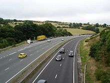
The A55 at Warren Mountain. | |
| Route information | |
|
Part of | |
| Maintained by Highways England (east of Junction 35a), North & Mid Wales Trunk Road Agency and UK Highways Ltd (west of Junction 11 in Anglesey). | |
| Length: | 87 mi (140 km) |
| Major junctions | |
| East end: | Chester |
| West end: | Holyhead |
| Location | |
| Primary destinations: |
Conwy Bangor |
| Road network | |

The A55, also known as the North Wales Expressway (Welsh: Gwibffordd Gogledd Cymru) and the Chester to Bangor Trunk Road,[1] is a major road in Britain. Its entire length is a dual carriageway primary route, with the exception of the point where it crosses the Britannia Bridge over the Menai Strait and several short sections where there are gaps in between the two carriageways. All junctions are grade separated except for two roundabouts — one east of Penmaenmawr and one in Llanfairfechan. The road originally ran from Chester to Bangor but was extended parallel to the A5 across Anglesey to just outside Holyhead Docks in 2001. The road improvements have been part funded with European money, under the Trans-European Networks programme, as the route is designated part of Euroroute E22 (Holyhead - Leeds - Amsterdam - Hamburg - Malmö - Riga - Moscow - Perm - Ekaterinburg - Ishim).
The A55 is sometimes called a motorway, because of its appearance, although it is not officially a motorway.[2]
Route
The Chester Southerly Bypass
The A55 begins at the end of the M53 motorway near Chester, where it is known as the Chester Southerly Bypass, crossing the River Dee and the Welsh border before passing close to Broughton then passing north of Buckley , Penyffordd and Northop. There is a major climb westbound between Broughton and Buckley (Junctions 35a to 35) though with no crawler lane. Junction 34/33b is point at which the A494 converges and then diverges with the A55. The road briefly has a three-lane section as westbound traffic from Queensferry can leave towards Mold. In the eastbound direction another short three-lane section allows vehicles to join the A494 or exit onto the A55 to Chester. Traffic taking the A55 into England must negotiate a tight 270 degree speed-limited single lane curve to climb up and over the A55/A494. Plans to upgrade the A494 between this junction at Ewloe and Queensferry were rejected by the Welsh Assembly Government on 26 March 2008 due to their scale.[3]
Ewloe to Colwyn Bay
From Ewloe, the road is relatively flat until after Northop when it climbs up onto the flanks of Halkyn Mountain range, passing to the southwest of Holywell with major climbs between Northop and Halkyn (Junctions 33 and 32b) and Halkyn and Holywell Summit (Junctions 32 and 31). This section of road is notorious for poor weather conditions including fog, ice and snow in winter months. In fine weather, however there are extensive views over the River Dee estuary to the Wirral Peninsula, Liverpool and beyond. The highest part of the road is in the vicinity of Brynford at around 790 feet (240 m). The steep descent towards St Asaph is down the new Rhuallt Hill (Junctions 29 to 28), which also provides the first views of the mountains of Snowdonia in the far distance. There is a crawler lane on Rhuallt Hill for eastbound traffic. The road bypasses St Asaph to the north, and runs past Bodelwyddan and Abergele to reach the North Wales coast at Pensarn (Junction 23A). From here onwards to Bangor, the route is close to the North Wales Coast railway.
Colwyn Bay Bypass
Two sections between (Junction 23) Llanddulas to (Junction 17) Conwy are signed as a 70 mph (110 km/h) speed limit because they are classed as non-motorway special roads. Unlike other sections of the A55 that have National Speed Limit (NSL) signage and are accessible to all motor vehicles, motorway restrictions (although it's not a motorway) apply on these stretches of road e.g. no pedestrians, learner drivers, farm vehicles etc. This is because these sections were built under legislation applicable to the building of motorways. But as they are not part of either the UK motorway network or are classed as an ordinary highway (public right of way), the national speed limit does not apply so 70 mph (110 km/h) signs (the maximum speed permitted on UK roads) are used instead.
A 50 mph (80 km/h) limit remains in force through the Colwyn Bay bypass (Old Colwyn to Mochdre). The restriction was imposed for several reasons. First as a safety precaution because the slip-roads on this stretch are unusually short due to the road's design. Part of it was built on a narrow swathe of land through the town that was once the North Wales coast railway; Colwyn Bay had to be rebuilt and the track bed realigned to complete the underpass. The former four-track railway was reduced to two more northerly tracks to make space for the road. Second the reduced speed limit was intended to reduce road noise for residents. However, since the completion of the Colwyn Bay bypass, the lower speed limit has been an unpopular decision with drivers.[4]
The Conwy Bypass
The crossing of the estuary of the River Conwy is by means of an immersed tube tunnel, the first of its kind constructed in the United Kingdom.[5]
The decision to construct an immersed tube tunnel bypass followed an extensive public consultation, named the Collcon Feasibility Study. This ruled out another bridge by the castle on aesthetic grounds, since it would have damaged the view of the world heritage site Conwy Castle, and the two bridges by Robert Stephenson and Thomas Telford. Another alternative bridge crossing was proposed at Deganwy, but this too was ruled out for aesthetic reasons. An inland alternative with heavy grades which would have passed over Bwlch y Ddeufaen pass at 430 metres (1,410 ft), following the old Roman road, was also worked up but rejected for cost and utility reasons.
The tunnel was constructed by a Costain/Tarmac Construction joint venture,[6] as pre-formed concrete sections, and then floated into position over a pre-prepared trench in the bed of the estuary. The 3 million tonnes of silt and mud extracted to create the trench in which the tunnel sections sat, were vacuumed to one side of the construction site, as to let them drift down river would have harmed the large mussel fishing beds downstream. The silt was deposited upstream of the bridge at Conwy which created a large new area of low-lying land which was subsequently given to the RSPB for a wildlife preserve. The casting basin for the tunnel sections was later converted into a new marina in the lower estuary. Because of the valuable fishery in the river and also because of the history of heavy metal mining in the catchment of the river, extensive ecological assessments were made both prior to the construction of the tunnel and subsequently. These studies finally concluded that no significant environmental damage had been caused.
After five years of construction, the tunnel was opened in October 1991 by Queen Elizabeth II, the tunnel initially had an advisory 50 miles per hour (80 km/h) speed limit, but this was dropped in 2007 as accidents were rare in the tunnels.
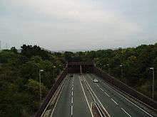
Penmaenbach and Pen-y-clip tunnels
Leaving Conwy in a westerly direction, the construction of this section has involved major civil engineering works because it crosses two major headlands: Penmaenbach Point and Penmaenan Point. Work has involved the cutting of several hard rock tunnels beneath the sea cliffs.
The first to be built in 1932 was the Penmaenbach Tunnel which carried motor traffic to Penmaenmawr. Two smaller tunnels through Penmaenan Point, opened 1935, carried the road onto Llanfairfechan. This new route, carrying traffic in both directions, relieved the original coach road built by Telford in the early 19th century. Cut into the cliffs by hand, this narrow, winding route hugged the contours around both steep headlands. Telford's route has now been converted into a cycleway across Penmaenbach and Penmaenan Points. Originally at the western end (Llanfairfechan) of the modern Pen-y-Clip tunnel, access was only allowed in an easterly direction because travelling the other way would mean heading the wrong way up the eastbound carriageway. However, in 2011 a purpose-built bridge - over the westbound carriageway - was constructed to allow unrestricted access to cyclists and walkers.
The 1930s alignment was used until a new two-lane Penmaenbach Tunnel opened in 1989 to carry westbound traffic. Eastbound traffic would now travel through the 1932 Penmaenbach Tunnel using both its original lanes. Four years later, work to build the Pen-y-clip tunnel was completed. Like at Penmaenbach it carried westbound traffic while the original road carried vehicles in the opposite direction. Both new routes were subject to an advisory 50 mph speed limit until these were lifted in 2007 as there had been few accidents.
However traffic travelling eastbound on the 1930s cliffhugging route still faced speed restrictions at both tunnel locations. For instance the eastbound carriageway at Penmaenbach is subject to a 30 mph (50 km/h) speed limit due to sharp curves and double white lines nominally preclude lane changing. Plans to rectify the awkward alignment by building another tunnel parallel to the current westbound tunnel (as originally intended when the westbound tunnel was proposed) have been discussed for several years. The Recent work (late 2007) at Penmaenbach eastbound has seen the erection of gantries to close lanes when bidirectional working is in place.
Penmaenmawr to Anglesey
Some sections of the rest of the route are of lower standard than that of those further east. Some traffic leaves for major holiday destinations such as Caernarfon or the Llŷn Peninsula, though much continues on to the port of Holyhead. As such part of the route is not classed as clearway and has two at grade junctions (roundabouts), Penmaenmawr (Junction 16) and Llanfairfechan (Junction 15). The Bangor bypass, in which the road previously terminated and became the A5 regains high standards and is such through the Anglesey section, bar the Britannia Bridge, which is a single carriageway deck above the North Wales Coast railway over the Menai Strait. In 2007 the Welsh Assembly Government undertook a consultation to determine which of four options would be preferred for a second crossing. This section intersects with the A487 towards Caernarfon, and the west coast of North Wales.
Anglesey

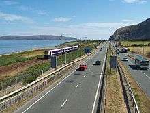
The final section of the A55 to be constructed was the Anglesey section. This 20 mile (32 km) section from the end of the Llanfairpwll bypass to Holyhead Harbour was constructed as Private Finance Initiative scheme where the builders, a Carillion / John Laing joint venture, earn a shadow toll based on usage and lane availability. They also have to maintain the road for the extended period of their shadow toll agreement. When travelling eastbound along this section there are fine views of Snowdonia. The approach to Holyhead required major work with a new section over the sea paralleling the Stanley Embankment that carries the original A5 and the North Wales Coast railway.
Planned improvements
The Welsh Assembly Government (WAG) published its National Transport Plan in July 2009.[7] This includes mention of improvements to the A55 including the possible removal of the two roundabouts at Penmaenmawr and Llanfairfechan. In November 2012, the Welsh Government published two more detailed studies looking at options to improve transport in the North East Wales and the A55 / A494 areas.[8] Possible changes to be considered further include
- applying managed motorway concepts
- providing hard shoulders
- providing crawler lanes at key points
- redesigning and improving slip roads.[9]
History
The A55 partly follows the alignment of the Roman road from Chester (Deva) to Caernarfon (Segontium), particularly from Junction 31 to 30 and Junction 13 to 12. Between Chester and Holywell the alignment of this road is uncertain and between St. Asaph and Abergele, the Roman road followed an inland route avoiding the difficulties of the crossing of the Conwy estuary and the cliffs at Penmaenbach and Pen-y-Clip.
A55 opening dates of major improvements
- Unknown date 1930s? Ewloe to Northop avoiding Northop Hall
- Unknown date 1930s? Northop Bypass
- Unknown date 1930s? Holywell Bypass
- Unknown date 1930s? St. Asaph to Rhuallt dual carriageway
- Unknown date 1930s? Short section of 'experimental' concrete road west of St Asaph
- 1932 Penmaenbach Tunnel
- 1935 Pen-y-Clip Tunnels
- 1958 Conway new bridge avoiding Telford's suspension bridge
- 1960s Tai'r Meibion to Tan-y-lon dual carriageway east of Bangor
- 1964? Ewloe roundabout (part of the A494 Queensferry to Ewloe dualling, the 'Aston Bypass')
- Unknown date 1965? Llysfaen dualling
- 1968 Abergele Bypass
- 1970 St. Asaph Bypass
- 1975 Northop Hall Crossroads to East of Gables
- 1976 Coed-y-Cra to Chaingates (Holywell)
- 1976 Chester Southerly Bypass (terminating at Broughton)
- 1980 Britannia Bridge and link roads
- December 1980 Holywell By-Pass (Stage 1)
- March 1981 Diversion East of Abergele
- December 1983 Bangor By-Pass
- September 1984 Hawarden By-Pass (from a point east of Broughton on the Chester Southerly Bypass to Northop Hall)
- December 1984 Llanddulas to Glan Conwy (Colwyn Bay By-Pass, Stage 1)
- June 1985 Llanddulas to Glan Conwy (Colwyn Bay By-Pass, Stage 2)
- October 1986 Holywell By-Pass (Stage 2)
- December 1986 Bodelwyddan By-Pass
- June 1989 Penmaenbach Tunnel
- June 1989 Northop By-Pass (Northop Hall to Halkyn)
- October 1989 Penmaenmawr and Llanfairfechan By-Passes (excluding Pen-y-Clip Tunnel)
- May 1990 Travellers' Inn Improvement
- 1991 tunnel crossing of the River Conwy
- June 1991 Extension of Chester Bypass to M53 (Junction 12)
- May 1992 Rhuallt Hill Improvement
- October 1993 Pen-y-Clip Tunnel
- October 1994 Abergwyngregyn Improvement
- 16 March 2001 Anglesey section (Llanfairpwll to Holyhead) including Llanfairpwll by-pass
- 2000/2004 Penmaenmawr eastbound slip road and grade separation at the summit of the Rhuallt Hill
- 2004 Improvements to railway underbridges and cliffs at Penmaenbach (eastbound)
- 2007 Alterations to roundabout at Llanfairfechan and bidirectional road indicators at Penmaenbach (eastbound)
- 2008 New overbridge between Junction 32A and 32B for improved local access
Services
There are two large services on the A55, along with numerous other petrol stations at the side of the road. The two major services are:
Bangor Services
(At J11) - Little Chef, Burger King, Travelodge, Esso, Costa Express
Gateway Services
Eastbound (After J33A) - Little Chef, Little Chef Express, Travelodge, Shell, Costa Express
Westbound (After J33B) - Costa Coffee, Subway, McDonald's, OK Diner, Holiday Inn, Shell, Costa Express, Deli2Go
Junctions
| A55 Road | |||||
| km | Westbound exits (B Carriageway) | Junction | Eastbound exits (A Carriageway) | ||
|---|---|---|---|---|---|
| 0.0 | Holyhead Ferry Port | Terminus [coord 1] |
Start of Road | ||
| 0.5 | Holyhead Town centre A5154 Amlwch A5 (A5025) |
Road junction |
Holyhead Town centre A5154 Amlwch A5 (A5025) | ||
| 0.7 | Trearddur Bay B4545 | J1 Roundabout |
Trearddur Bay B4545 | ||
| 1.2 2.0 |
A5153 | J2 | A5153 | ||
| 7.1 7.7 |
Caergeiliog, Valley A5 Amlwch A5025 |
J3 | Caergeiliog, Valley A5 Amlwch A5025 | ||
| 9.6 10.2 |
Caergeiliog, RAF Valley, Bryngwran A5 | J4 | Caergeiliog, RAF Valley, Bryngwran A5 | ||
| 14.0 14.6 |
Bryngwran, Gwalchmai A5 Rhosneigr A4080 |
J5 | Bryngwran, Gwalchmai A5 Rhosneigr A4080 | ||
| 23.2 24.0 |
Pentre Berw, Gwalchmai A5 Llangefni A5114 |
J6 | Pentre Berw A5 Llangefni A5114 | ||
| 27.8 28.6 |
Gaerwen A5152 | J7 | Gaerwen A5152 | ||
| 31.3 | No access Llanfair PG A5 |
J7A | No exit Access only | ||
| 32.9 33.4 |
Llanfair PG, Benllech A5025 | J8 | Llanfair PG, Benllech A5025 | ||
| 33.8 | No access Llanfair PG, Menai Bridge A5 |
J8A | No exit Access only | ||
| 34.1 34,4 |
Britannia Bridge | Bridge [coord 2] |
Britannia Bridge | ||
| 35.3 35.6 |
Bangor, Menai Bridge, Ysbyty Gwynedd A487 | J9 | Caernarfon, Menai Bridge, Ysbyty Gwynedd A487 | ||
| 36.4 37.0 |
Caernarfon, Bangor A4087 | J10 | Bangor A4087 | ||
| 40.3 40.9 |
Bangor, Bethesda A5 B4366 |
J11 | Bethesda A5 B4366 | ||
| 43.6 44.2 |
Talybont | J12 | Talybont | ||
| 47.2 47.5 |
Abergwyngregyn | J13 | Abergwyngregyn | ||
| 48.9 49.2 |
Llanfairfechan | J14 | Llanfairfechan | ||
| 51.7 | Llanfairfechan | J15 Roundabout |
Llanfairfechan | ||
| 52.8 53.7 |
Pen-y-Clip Westbound Tunnel (930 m)[10] | Tunnel | Two short tunnels | ||
| 53.8 54.2 |
access only No exit |
J15A | Penmaenmawr | ||
| 56.2 | Penmaenmawr | J16 Roundabout |
Penmaenmawr | ||
| 57.8 57.8 |
Dwygyfylchi | J16A | No exit | ||
| 58.4 59.1 |
Penmaenbach Westbound Tunnel (658 m)[10] | Tunnel | Penmaenbach Eastbound Headland Tunnel(172 m)[10] | ||
| 60.4 61.0 |
Conwy A547 | J17 | Conwy A547 | ||
| 61.8 62.9 |
Conwy Road Tunnel (1080 m)[10] Restrictions apply |
Tunnel [coord 3] |
Conwy Road Tunnel Restrictions apply | ||
| 63.6 64.2 |
Conwy (A547) | J18 | Llandudno Junction A546 | ||
| 64.8 65.5 |
Llandudno, Llanrwst A470 Llandudno Junction |
J19 | Llandudno, Llanrwst A470 Colwyn Bay (A547) Llandudno Junction | ||
| 68.7 69.8 |
Colwyn Bay, Mochdre, Penrhyn Bay B5115 | J20 | Colwyn Bay, Mochdre, Penrhyn Bay B5115 | ||
| 70.6 71.0 |
Colwyn Bay A547 | J21 | Colwyn Bay A547 | ||
| 71.5 72.0 |
Old Colwyn A547 | J22 | Old Colwyn A547 | ||
| Start of Special road | End of Special road | ||||
| 76.0 76.1 |
Llanddulas A547 Prohibited Traffic |
J23 | Llanddulas A547 | ||
| 80.0 80.4 |
Access only No exit |
J23A | Pensarn, Abergele A548 No access | ||
| 81.2 81.9 |
Abergele, Rhuddlan A547 | J24 | Abergele, Rhuddlan A547 | ||
| 84.6 | no access St. George, Towyn |
J24A | No exit no access | ||
| 86.7 86.8 |
Bodelwyddan, Ysbyty Glan Clwyd | J25 | Bodelwyddan, Ysbyty Glan Clwyd | ||
| 88.2 88.8 |
St Asaph Business Park | J26 | St Asaph Business Park | ||
| 89.9 90.6 |
St Asaph, Trefnant, Denbigh, Rhuddlan, Rhyl A525 | J27 | St Asaph,Trefnant, Denbigh, Rhuddlan, Rhyl A525 | ||
| 91.6 91.6 |
St Asaph A525 | J27A | No exit No access | ||
| 92.9 93.2 |
Rhuallt, Rhuddlan B5429 | J28 | Rhuallt B5429 | ||
| 96.7 97.3 |
Rhuallt | J29 | Rhuallt | ||
| 99.0 99.3 |
Pen-y-Cefn | J30 | Pen-y-Cefn | ||
| 100.3 100.8 |
Trelawnyd A5151 Caerwys B5122 |
J31 | Holywell A5151 Caerwys B5122 | ||
| 108.7 108.8 |
no access Holywell A5026 |
J32 | Holywell A5026 Halkyn, Pentre Halkyn No access | ||
| 109.3 109.9 |
Pentre Halkyn | J32A | No exit Access only | ||
| 111.3 111.4 |
Halkyn | J32B | No exit No access | ||
| 114.6 115.3 |
Northop, Flint, A548 Coast Road A5119 | J33 | Northop, Flint, Mold A5119 | ||
| 116.5 | No access Connah's Quay B5126 |
J33A | No exit No access | ||
| 117.8 117.9 |
No exit | Northop Hall | |||
| 120.0 | No access Mold A494 |
J33B | No exit Access only | ||
| 120.5 128.8 |
Ewloe, Queensferry A494 Manchester (M56) |
J34 "Totso"[See notes] |
Ewloe, Queensferry A494 Manchester (M56) | ||
| 123.1 123.6 |
Hawarden, Buckley, Corwen A550 | J35 | Hawarden, Wrexham A550 | ||
| 125.3 125.9 |
Penyffordd | J35A | Broughton, Saltney A5104 | ||
| 128.5 | no access Broughton (A5104) |
No exit Access only | |||
| 128.6 | Entry into Wales | Border | Entry into England | ||
| Wrexham, Chester A483 | J36 | Wrexham, Chester A483 | |||
| Access only No exit |
J36a | Chester A5115 Whitchurch (A41) No access | |||
| Chester Nantwich, Northwich A51 Whitchurch (A41) |
J37 | Chester Nantwich, Northwich A51 | |||
| Start of road | M53 J12 [coord 4] |
Chester, Helsby A56 Non-motorway traffic | |||
| Chester, Helsby A56 | Road continues as M53 to Wallasey | ||||
Notes
| |||||
Coordinate list
| |||||
| 1.000 mi = 1.609 km; 1.000 km = 0.621 mi | |||||
See also
References
- ↑ "The Chester to Bangor Trunk Road (A55), Talerdy Junction Phase 2, St Asaph - Environmental Impact Assessment". Welsh Government. Archived from the original on 6 June 2014. Retrieved 2014-06-05.
- ↑ e.g
- ↑ Welsh Assembly Government - Decision on A494 Drome Corner to Ewloe scheme Archived 30 March 2012 at the Wayback Machine.
- ↑ "50mph limit at Colwyn Bay should be scrapped say drivers". www.walesonline.co.uk/. 7 June 2012.
- ↑ "Conwy Tunnel praised on 20th anniversary". BBC News. 25 October 2011.
- ↑ Motoway archive
- ↑ Welsh Government | National Transport Plan
- ↑ "Studies to improve transport in North East Wales published". Welsh Labour. 12 November 2012. Archived from the original on 4 March 2016. Retrieved 2012-12-30.
- ↑ "A55 A494 WelTAG Study – Stage 1 Appraisal" (PDF). Welsh Government. 2012-11-12. Retrieved 2012-12-30.
- 1 2 3 4 "Tunnels". North Wales Trunk Road Agency. 2011. Archived from the original on 18 March 2012. Retrieved 2011-09-04.
- ↑ "Resources". Traffig Cymru/Traffic Wales. Archived from the original on 3 September 2011. Retrieved 2011-08-22.
Select Telephone & marker post locations.
External links
- Traffic Wales - containing A55 webcams
- SABRE Roaders Digest - A55
- Images of diversion of North Wales Coast Railway at Colwyn Bay to accommodate A55
- BBC News - Engineers look at more A55 relief - 03/09/2004
- The Motorway Archive - A55
- The Chester-Bangor Trunk Road (A55) (Rhuallt Hill Improvement and Slip Roads) Order 1989 (S.I. 1989/2091)
- Other Statutory Instruments pertaining to the A55
- Roads UK: A55
- North East Wales Area Based Transport Study November 2012
- A55 A494 WelTAG Study – Stage 1 Appraisal November 2012
A roads in Zone 5 of the Great Britain road numbering scheme | ||
|---|---|---|
Trunk Roads in Wales | ||
|---|---|---|
| Managed by the North and Mid Wales Trunk Road Agent |
|  |
| Managed by the South Wales Trunk Road Agent |
| |
| Related topics and further information | ||