Ysyk-Ata District
| Ysyk-Ata | |
|---|---|
| Raion | |
|
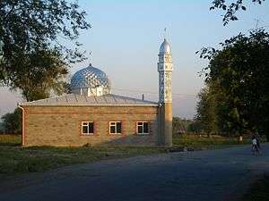
The new mosque in Pervomayskoe village | |
 | |
| Country | Kyrgyzstan |
| Region | Chuy Region |
| Population (2009)[1] | |
| • Total | 132,759 |
| Time zone | GMT +5 (UTC+5) |

Ysyk-Ata District (Russian: Ысык–Атинский район) is one of the eight districts of the Chuy Region in northern Kyrgyzstan. The administrative center of the district is the city of Kant, and the district itself was known as Kant District in the past. The district is located on the southern side of the Chui River, about halfway between the national capital Bishkek and the former provincial capital Tokmok.
The district's land area 1,900 square km; population 131,503, of which 21,762 live in the district center, the city of Kant.
Air force base and school
In 1941, a Soviet Air Force base and pilot training school were set up in the district. During World War II, 1507 military pilots were trained there. Since 1956, the school trained foreign pilots; among its graduates were both the ex-Egyptian president Hosni Mubarak and the late Syrian president Hafez Assad.
In 1992, the air base was transferred to Kyrgyzstan authorities; since 2003 it hosts Russian Air Force units. [2]
Water erosion
The district authorities, as well as the residents of the riverside village of Milianfan (Russian: Милянфан), are concerned with the River Chui gradually washing away the district's land, as it shifts its course to the south and erodes its left (southern) bank.[3]
Demographics
As of 2009, Ysyk-Ata District included 1 town, and 58 villages in 18 rural communities (aiyl okmotus).[4] Its de facto population, according to the Population and Housing Census of 2009, was 131,503, and de jure population 132,759. Some 21,762 people live in urban areas, and 109,741 in rural ones.
| Historical populations in Ysyk-Ata District | ||
|---|---|---|
| Year | Pop. | ±% |
| 1970 | 99,172 | — |
| 1979 | 109,351 | +10.3% |
| 1989 | 128,371 | +17.4% |
| 1999 | 125,116 | −2.5% |
| 2009 | 131,503 | +5.1% |
| Note: enumerated de facto population; Source:[1] | ||
Ethnic composition
According to the 2009 Census, the ethnic composition of the Nookat District (de jure population) was:[1]
| Ethnic group | Population | Proportion of Kemin District population |
|---|---|---|
| Kyrgyzs | 62,620 | 47.2% |
| Russians | 28,000 | 21.1% |
| Dungans | 19,223 | 14.5% |
| Turks | 4,699 | 3.5% |
| Uygurs | 4,091 | 3.1% |
| Azerbaijanis | 3,486 | 2.6% |
| Germans | 1,524 | 1.1% |
| Ukrainians | 1,343 | 1.0% |
| Kazakhs | 1,317 | 1.0% |
| Tatars | 1,078 | 0.8% |
| Balkars | 611 | 0.5% |
| Koreans | 588 | 0.4% |
| Tadjiks | 383 | 0.3% |
| Kurds | 349 | 0.3% |
| Karachays | 182 | 0.1% |
| Bulgars | 108 | 0.1% |
| other groups | 950 | 0.7% |
Populated places
- town Kant, Kyrgyzstan
- Ak-Kuduk aiyl okmotu (center - village Kirovskoe, and also villages Ak-Kuduk, Kotovskoe, Pervomayskoe)
- Birdik aiyl okmotu ( center - village Birdik)
- Ivanovka aiyl okmotu (center - village Ivanovka)
- Jeek aiyl okmotu (center - village Dmitriyevka, and also villages Imeni Gagarina, Jeek)
- Internatsionalnyi aiyl okmotu (center - village Internatsionalnoe, and also village Jar-Bashi)
- Kenbulun aiyl okmotu (center - village Kenbulun, and also villages Gidrostroitel, Druzhba, Cholpon)
- Kochkorbaev aiyl okmotu (center - village Kenesh and also villages Budenovka, and Dokturbek Kurmanaliev)
- Krasnorechenskiy aiyl okmotu (center - village Krasnaya Rechka)
- Logvinenko aiyl okmotu (center - village Novopokrovka, and also village Chong-Daly)
- Luksemburg aiyl okmotu (center - village Luksemburg, and also village Kirshelk)
- Milyanfan aiyl okmotu (center - village Milyanfan)
- Novopokrovka aiyl okmotu (center - village Novopokrovka, and also village Leninskoe, Sary-Jon)
- Nurmanbet aiyl okmotu (center - village Nurmanbet, and also villages Pervomayskoe, Imeni Aliaskara Toktonalieva)
- Syn-Tash aiyl okmotu (center - village Imeni Tel'mana, and also villages Ak-Say, Jetigen, Kyzyl Aryk, Otogon, Rot-Front, Sovetskoe, Syn-Tash)
- Tuz aiyl okmotu (center - village Tuz, and also villages Dayyrbek, Jayalma, Nizhnyaya Serafimovka)
- Uzun-Kyr aiyl okmotu (center - village Jer-Kazar, and also villages Druzhba, Nizhniy Norus)
- Yurevka aiyl okmotu (center - village Yur'evka and also village Ysyk-Ata)
- Ysyk-Ata aiyl okmotu (center - village Almaluu, and also villages Gornaya Serafimovka, Jogorku Ichke-Suu, Ichke-Suu, Karagay Bulak, Norus, Tash-Bashat, Toguz-Bulak, Uch-Emchek)
Sources
- Ysyk-Ata District data at the provincial administration web site. (Russian)
- 1 2 3 Population and Housing Census 2009. Book 3 (in tables). Provinces of Kyrgyzstan: Chuy Province (Перепись населения и жилищного фонда Кыргызской Республики 2009. Книга 3 (в таблицах). Регионы Кыргызстана: Чуйская область (PDF), Bishkek: National Committee on Statistics, 2010
- ↑ Санкт-Петербург взял шефство над российской авиационной базой в городе Кант (Киргизская Республика)
- ↑ Ползущая Чу. Территория Кыргызстана уменьшается с каждым годом ("The creeping Chui. The land of Kyrgyzstan shrinks every year") Вечерний Бишкек (Vecherniy Bishkek), No. 247, 2004-Dec-31.
- ↑ List of Rural Communities of Kyrgyzstan
Capital: Bishkek (also four raions: Lenin, Oktyabr, Pervomay, Sverdlov) | ||
| Batken Region | 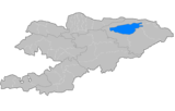 | |
| Chuy Region | ||
| Issyk Kul Region | ||
| Jalal-Abad Region | ||
| Naryn Region | ||
| Osh Region | ||
| Talas Region | ||
 |
Kazakhstan |
| |||||
| |
|||||||
| Alamudun District, Chuy Province | |
Chuy District, Chuy Province | |||||
| |
|||||||
| Panfilov District, Chuy Province | Kochkor District, Naryn Province |
Coordinates: 42°53′N 74°51′E / 42.883°N 74.850°E